Browse Listings
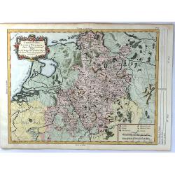
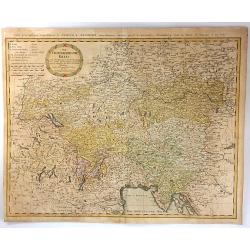
Chorographie du Cercle de Westphalie d'apres Visscher
An attractive map of present day Netherlands, and the North West part of Germany. With a decorative floral cartouche at top left, scales at lower right. Published by Phil...
Place & Date: Paris, 1787
Selling price: $22
Sold in 2016
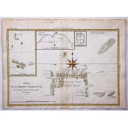
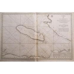
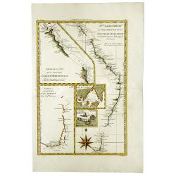
Isles de la Reine Charlotte.
Queen Charlotte Island map based on Captain Cook's voyages showing part of the Solomon Islands, located east of Papua New Guinea.The Isle du Lord Edgemont and Isle du Lor...
Place & Date: Paris, 1787
Selling price: $17
Sold in 2017
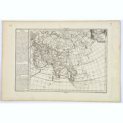
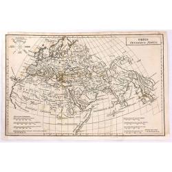
Asia veteribus nota.
A fine map of ancient Asia by Philippe de Pretot, published in Paris in 1787. The map features a decorative ribbon & drape title cartouche.Interestingly, there are sc...
Place & Date: Paris, 1787
Selling price: $60
Sold in 2018
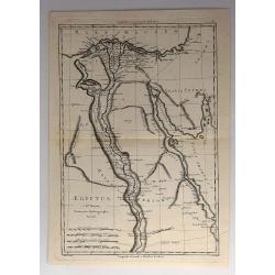
Aegyptus.
An attractive 18th century map of Egypt, published by Rigobert Bonne, the Royal Hydrographer to the King of France. It features the Nile River from the mouth to the Tropi...
Place & Date: Paris, 1787
Selling price: $27
Sold in 2017
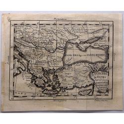
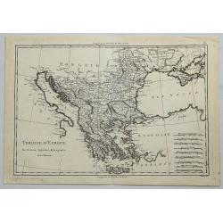
La Turchia in Europe....
La Turchia in Europe. A map of Turkey in Europe including Greece from the Gulf of Venice and Italy to Crete / Candia, to the Crimea and Black Sea.Engraved by Giovanni Pet...
Place & Date: Rome, 1787
Selling price: $120
Sold in 2017
![[untitled map showing the route of the Continental Army from Boston to Yorktown]](/uploads/cache/40226-250x250.jpg)
[untitled map showing the route of the Continental Army from Boston to Yorktown]
Revolutionary War Battle map covering the East Coast of America from Boston Harbor to the Pamptico River in North Carolina. Its primary purpose is to depict the route of ...
Place & Date: Paris, c. 1787
Selling price: $750
Sold in 2018
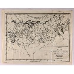
Carte de la Russie Asiatique ou Tartatie Russe.
A map of Asian Russia stretching from the Urals to the Pacific Ocean, divided into its various Provinces. From L’HISTOIRE DE RUSSE.Louis Brion de la Tour, (1743 – 180...
Place & Date: Paris, 1787
Selling price: $15
Sold in 2018
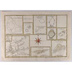
Esquisse de la Baye Dusky dans la Nouvelle Zeelande.
Group of hand colored engraved maps of Pacific islands in compartments on one sheet. These islands were described by Captain James Cook on one of his expeditions between ...
Place & Date: Paris, 1787
Selling price: $20
Sold in 2018
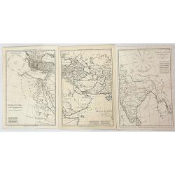
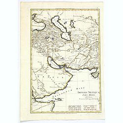
Imperia Antiqua. Pars Occidentalis/ Pars Media/ Pars Orientalis (Three Maps)
Three associated maps from Rigobert Bonne's "Atlas Encyclopedique", together depicting the eastern part of the Mediterranean, the Near East and the Indian subco...
Place & Date: Paris, 1787
Selling price: $100
Sold in 2023
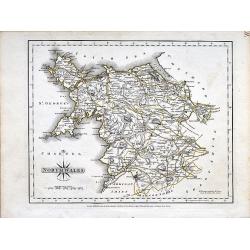
North Wales.
A small copper engraved map of north Wales issued by John Cary. Marks towns and cities and the main connecting roads.
Place & Date: London, 1787
Selling price: $15
Sold in 2019
Turquie D'Europe.
A fine, detailed, antique map of Greece, by Bonne, published in the 1787 “Atlas Encyclopedique”.Rigobert Bonne (1727–1794) was one of the most important cartographe...
Place & Date: Paris, 1787
Selling price: $17
Sold in 2018
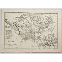
Tartarie Independante.
A fine, detailed, antique map of Tartary from the Black Sea to China and from Siberia to Tibet, by Bonne, published in the 1787 “Atlas Encyclopedique”.Rigobert Bonne ...
Place & Date: Paris, 1787
Selling price: $20
Sold in 2021
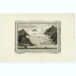
View of an Iceberg in the Island of Spitsbergen.
An attractive, and unusual engraving by C. Stalker, for Hervey's New System of Geography. The print shows a large Iceberg in between mountains on the Arctic island of Spi...
Place & Date: London, 1787
Selling price: $35
Sold in 2018
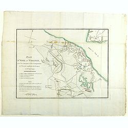
Plan d'York en Virginie, avec les attaques et les campemens de l'Armee combinee de France et d'Amerique
Map showing the battle of Yorktown, the final battle of the American Revolution, based upon French sources. The positions of the American, French and English forces and a...
Place & Date: Paris, Buisson, 1787
Selling price: $350
Sold in 2020
A Chart of the Isle of Java, with the Islands of Banca and Billiton. . .
An English edition, published by Robert Sayer in London, of the Island of Java, Banca, Billiton, and part of Sumatra and Borneo. With an iInset part of Lubeck Island. Lat...
Place & Date: London, 1787
Selling price: $400
Sold in 2021
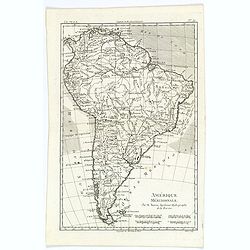
Amérique Méridionale.
A fine map of the South American continent, prepared by R.Bonne and included in his Atlas Encyclopédique. Plenty of good map detail, including hills, mountains, rivers p...
Place & Date: Paris, 1787
Selling price: $25
Sold in 2020
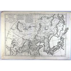
Tartarie Chinoise, Roy. De Coree et Isles du Japan.
A fine map of the Asian region including Japan, Korea, Manchuria and the Gobi Desert. Highly detailed. From Bonne's 'Atlas Supplement'.Rigobert Bonne (1727–1795) was a ...
Place & Date: Paris, 1787
Selling price: $17
Sold in 2023
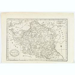
Poland shewing the Claims of Austria, Russia & Prussia.
A plain and simple map of Poland highlighting the claims of Austria, Russia & Prussia. Various portions of Poland were carried out by Austria, Russia and Prussia in 1...
Place & Date: London, ca 1787
Selling price: $50
Sold in 2019
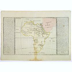
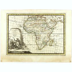
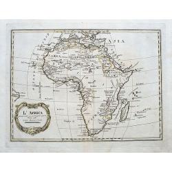
Lacs, Fleuves, Rivieres et Principales Montagnes de L'Afrique.
An interesting map of the lakes, rivers and mountains of Africa. The history of the region is featured to the sides explained in French text. Published by Mondhare et Jea...
Place & Date: Paris, 1787
Selling price: $40
Sold in 2020
Imperia Antiqua. Pars Media.
A map of the Near East from Rigobert Bonne's "Atlas Encyclopedique." Rigobert Bonne (1727-1795) was one of the most important cartographers of the late 18th cen...
Place & Date: Paris, 1787
Selling price: $1
Sold in 2021
An Index Map to the Antiquities; of England and Wales. Shewing the Situation of every building described in this work.
A large and unusual map showing the counties, rivers, major cities, castles, etc. Extends from Holy Island of Lindisfarne until the Channel Islands. Engraved by Francis V...
Place & Date: London, 1787
Selling price: $17
Sold in 2019
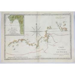
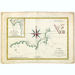
Carte de la Terre Van-Diemen.
An unusual 1787 Rigobert Bonne copper engraved map of Tasmania, then called 'Van Dieman's Land'. It includes an inset map of Adventure Bay and shows the route of Captain ...
Place & Date: Paris, 1787
Selling price: $105
Sold in 2019
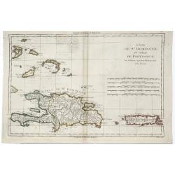
L'Isle de St. Domingue et Celle de Porto-Rico.
A detailed map of Santa Domingo, Puerto Rico, etc. Includes substantial topographical detail. Includes Eastern Bahamas. From Bonne's "Atlas Supplement".Rigobert...
Place & Date: Paris, 1787
Selling price: $32
Sold in 2019
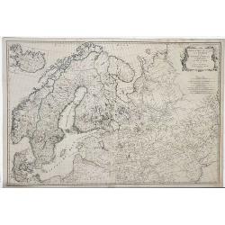
Zwieter Theil der Karte von Europe, Welcher Dænemark, und Norwegen, Sweden, und Russland Enthælt.
Detailed 1787 Schraembl map of the Scandinavian Peninsula, printed in two sheets which have now been joined. It covers Sweden, Denmark, Norway, Finland, Latvia, Estonia...
Place & Date: Vienna, 1787
Selling price: $77
Sold in 2019
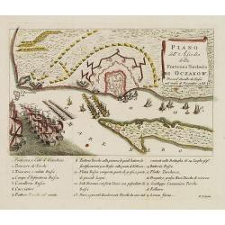
Piano dell'Assedio della Fortezza Turchesca di Oczakow : presa d'Assalto da' Russi nel mese di Decembre 1788.
Plan of Ochakiv (Ukraine) published by Antonio Zatta. Below the engraving (151x243mm.) is a numbered key, 1-19 showing the points of interest to this siege of Ochavik by ...
Place & Date: Venice, after 1788
Selling price: $650
Sold in 2012
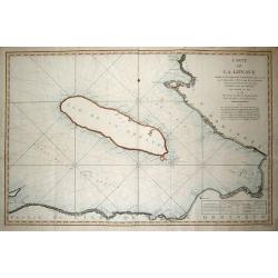
CARTE DE LA GONAVE...
Fantastic large-scale chart of the island of Gonave. Includes also the coasts of Haiti, with Saint-Marc, Port-au-Prince, Leogane, Petit and Grand Goave. Filled with numer...
Place & Date: Paris, 1788
Selling price: $60
Sold in 2013
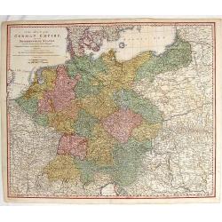
A New Map of Germany and Its Neighbouring States.
Large, detailed map of Germany and portions of Poland, Hungary, Denmark and Italy. It was originally published by the Royal Academy of Berlin. William Faden (1750 - 1836...
Place & Date: London, c1788
Selling price: $109
Sold in 2014
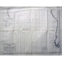
Carte des déclinaisons et inclinaisons de l'aiguille aimantée...1775
Large sea-chart of the south Pacific, indicating the magnetic variations of the compass needle. Includes the coast of South America and extends to include Tahiti. An int...
Place & Date: Paris, 1788
Selling price: $120
Sold in 2013
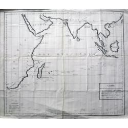
Carte des déclinaisons et inclinaisons de l\'aiguille aimantée...1775
Rare large sea-chart of the Indian Ocean, indicating the magnetic variations of the compass needle. The map shows the coasts of Africa, Madagascar, Arabia, India, South ...
Place & Date: Paris, 1788
Selling price: $190
Sold in 2016
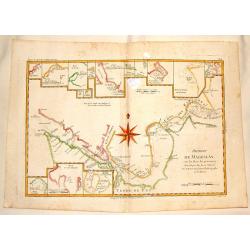
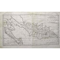
Detroit de Magellan avec les Plans des Pricipaux, Ports, Baves & de ce Detroit.
Interesting hand-colored, copperplate map of The Straits of Magellanshowing the direction of the currents, bays, points, soundings, harbours, islands, shoals etc. Large c...
Place & Date: Paris, 1788
Selling price: $17
Sold in 2015

Set of 9 plates from \"Voyage de Pallas\".
An interesting collection of nine rare copper engraved plates with Russian and Mongolian people, gods, and costumes. Engraved by N. Thomas: "Femmes Mordouanes d...
Place & Date: Paris, c1788
Selling price: $150
Sold in 2013
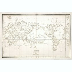
Mappemonde ou carte réduite des parties connues du globe.
A world map in Mercator projection to illustrate the voyages made by La Perouse in the years 1785-1788. Jean François Galaup, Comte de la Pérouse (1741-1788), outstandi...
Place & Date: Paris, 1788
Selling price: $750
Sold in 2014
Carte de la Gonave...
Fantastic large-scale sea-chart of the island of Gonave. Includes also the coasts of Haiti, with Saint-Marc, Port-au-Prince, Leogane, Petit and Grand Goave. Highly detail...
Place & Date: Paris, 1788
Selling price: $22
Sold in 2014
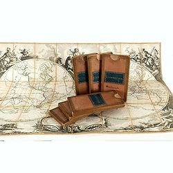
Set of World and Continents in original slip cases.
A fine set of the world in double hemisphere, North and South America, Asia, Africa and Europe. The maps are prepared by Louis Brion de la Tour (1756-1823) and published ...
Place & Date: Paris, Esnauts et Rapilly, ca. 1783-1788
Selling price: $6000
Sold
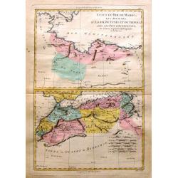
Etats du Roi de Maroc & Sahra ou Desert de Barbarie
Two maps on one page depicting North Africa and featuring Marocco, Algeria and Lybia as well as the Sahara Desert. It is by Rigobert Bonne from "Atlas Encyclopedique...
Place & Date: Paris, 1788
Selling price: $17
Sold in 2016
Route de M. de Lesseps,... dans la presqu\'île de Kamtschatka...
Rare and important map of Kamchatka. Shows the Peninsula with new discoveries. Many place names and rivers named. Jean-Baptiste Barthélemy de Lesseps was a translator o...
Place & Date: Paris, c1788
Selling price: $100
Sold in 2015
Carte de la Terre Van-Diemen.
Handsome chart of the southern coast of Tasmania with a detailed inset "Plan de la Baye de l'Aventure sur la Terre Van-Diemen." The chart is centered on a large...
Place & Date: Paris, 1787-1788
Selling price: $150
Sold in 2018
L' Amérique divisée en tous ses pays suivant, les nouvelles observations des plus celébres navigateurs. . . 1788
Rare wall map of the Americas and the north-west part of Africa, published by Jean and Louis Joseph Mondhare. Only mentioned by Tooley as a single chart with the one date...
Place & Date: Paris: Mondhare et Jean, 1788
Selling price: $1200
Sold in 2023
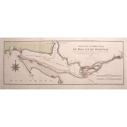
Confluent et Embouchure du Bog et du Dniéper. . .
Rare chart of the mouth of the Dnieper River into the Black Sea. Locates Kherson (Cherson) and Otchakof (Ochakiv). With many depth soundings.We were unable to identify th...
Place & Date: Vienna, 1788
Selling price: $175
Sold in 2015
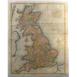
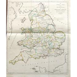
A New and Correct Map of Great Britain from the Most Accurate Surveys.
Map of England, Scotland and Wales with the individual counties named and outlined. Hadrian's Wall & Severus Wall are shown but not labeled.Thomas Bowen (died 1790) w...
Place & Date: London, 1788
Selling price: $35
Sold in 2016
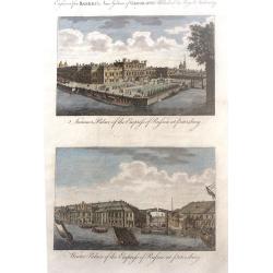
Summer Palace of the Empress of Russia at Petersburg and Winter Palace of the Empress of Russia at Petersburg
Two beautiul Russian scenes - "Summer Palace of the Empress of Russia at Petersburg" and "Winter Palace of the Empress of Russia at Petersburg", by an...
Place & Date: London, 1788
Selling price: $19
Sold in 2017
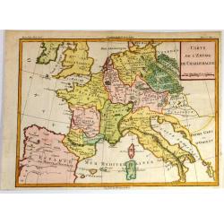
Carte de l'Empire de Charlemagne.
Striking decorative copper engraved French edition map of the European Continent at the time of the Emperor Charlemagne. Cannot find this exact map on the Internet.
Place & Date: Paris, 1788
Selling price: $80
Sold in 2017

A Map of Hertfordshire, Engraved from an Actual Survey, with Improvements.
An uncommon late eighteenth-century map of the county - neatly engraved by Edward Sudlow (1784-1793). Originally produced as one of John Harrison's series of maps publish...
Place & Date: London, 1788
Selling price: $6
Sold in 2016
Orbis Veteribus Notus
Finely engraved map of the Ancient World, that includes Europe, Asia and North Africa.
Place & Date: London, 1788
Selling price: $40
Sold in 2016
![Untitled [Virginia Land Grant With Manuscript Map]](/uploads/cache/36846-250x250.jpg)
Untitled [Virginia Land Grant With Manuscript Map]
A fascinating item of colonial ephemera, this land grant printed on vellum with hand-written infill includes a manuscript map of the 2000 acres, set within a rectangular ...
Place & Date: Richmond, Virginia 1788
Selling price: $2200
Sold in 2016
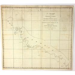
A chart of the Track of the Alexander on Her Homeward Passage from Port Jackson on the Eastn. Coast of New South Wales to Batavia; Performed in the Year 1788 under the Direction of Lieut. John Shortland by Thomas George Shortland
Shortland was appointed the naval agent to the First Fleet, and it was his responsibility to ensure that the contracts for transport were fulfilled. The Alexander, a 450 ...
Place & Date: London, 1788
Selling price: $143
Sold in 2018
Der Oesterreichische Kreis.
The map shows the ancient Austrian Empire with the Duchy of Austria, Styria, KŠrnten, Krain (Slowenia) Istria, Tyrol, and diocese Trient. In 1716, Homann published his m...
Place & Date: Nuremberg, 1788
Selling price: $45
Sold in 2016
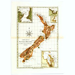
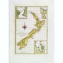
Carte de la Nouvelle Zéelande.
Rigobert Bonne's map appears in his Atlas Encylopedique . It is the best known printed summary of all Cook's maps pertaining to Australia and New Zealand. Cook's circumna...
Place & Date: Paris, 1788
Selling price: $350
Sold in 2017
![[2 sheets] Carte de Moscovie...](/uploads/cache/38419-250x250.jpg)
[2 sheets] Carte de Moscovie...
Dezauche's large two sheet map, based on the earlier map by de Lisle, of western Russia from Lapland, and the White sea in the north, to the Sea of Azov, and the Crimea i...
Place & Date: Amsterdam, ca. 1788
Selling price: $276
Sold in 2017
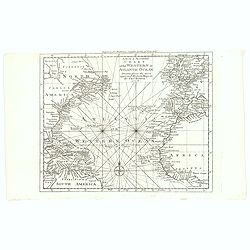
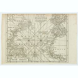
A New & Accurate Chart of the Western or Atlantic Ocean.
A map from 'Middleton's Complete System of Geography', from the Arctic Ocean in the north, south to the top of South America and across to the Slave Coast of Africa. Fro...
Place & Date: London, 1788
Selling price: $80
Sold in 2016
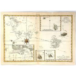
Carte des Isles des Amis
A finely engraved chart depicting the Friendly Islands, including the Kingdom of Tonga.The islands were discovered by Captain Cook, and his passage aboard the Resolution ...
Place & Date: Paris, 1788
Selling price: $30
Sold in 2021
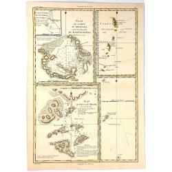
Plan de la Baye d'Awatska sur la Cote du Kamschatka
An interesting map of several countries along the east coast of Asia.
Place & Date: Paris, 1788
Selling price: $15
Sold in 2020
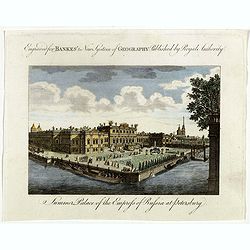
Summer Palace of the Empress of Russia at Petersburg.
Showing the "Summer Palace of the Empress of Russia at Petersburg". Published in Thomas Bankes's “New System of Universal Geography”
Place & Date: London, 1788
Selling price: $15
Sold in 2018
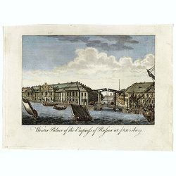
Winter Palace of the Empress of Russia at Petersburg.
Showing the "Winter Palace of the Empress of Russia at Petersburg". Published in Thomas Bankes's “New System of Universal Geography”.
Place & Date: London, 1788
Selling price: $15
Sold in 2018
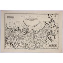
Carte de L'Empire de Russie.
A fine map of the empire of Russia by Bonne published in Paris in 1788. It embraced both Russia in Europe and Russia in Asia. Rigobert Bonne (1727-1795) was one of the mo...
Place & Date: Paris, 1788
Selling price: $17
Sold in 2019
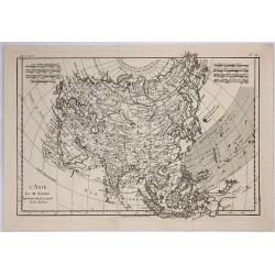
Asia.
A fine map of Asia. It covers the area from Italie to Australia.Rigobert Bonne (1727-1795) was one of the most important cartographers of the late 18th century. In 1773 h...
Place & Date: Paris, 1788
Selling price: $17
Sold in 2020
Der Rhein Die Maass und Mosel mit den anliegenden Landern des Ober-Chur und Neider-Rhein. . .
A fine, detailed Johann Baptist Homann's map of the Maass and Moselle areas of the Rhine with the adjoining lands of the Upper Chur and the Neider-Rhine. This map feature...
Place & Date: Nuremberg, 1788
Selling price: $31
Sold in 2018
L'Africa secondo Le ultime osserviazioni divisa né suoi stati principali.
First edition on laid paper. Cassini’s splendid map depicts Africa at the end of the eighteenth century.More about Giovanni Maria Cassini [+]
Place & Date: Rome, 1788
Selling price: $500
Sold in 2019
Carte de la Nouvelle Zéelande.
Rigobert Bonne's map appears in his Atlas Encylopedique. It is the best known printed summary of all Cook's maps pertaining to Australia and New Zealand. Cook's circumnav...
Place & Date: Paris, 1788
Selling price: $395
Sold in 2018
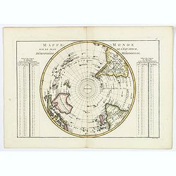
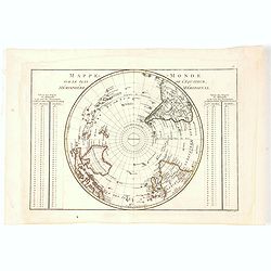
Mappe-Monde sur le plan de l'Equateur, Hemisphere Meridional.
An attractive double-page map of the Southern Hemisphere centered on the South Pole, from the South Pole up to the Equator. From the Atlas Encyclopédique contenant la G�...
Place & Date: Paris, 1788
Selling price: $65
Sold in 2019
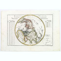
Mappe-Monde, sur le plan de l'Equateur, Hemisphere Septentrional.
An attractive double-page hemisphere map on a (north) polar projection from the North Pole down to the Equator. From the Atlas Encyclopédique contenant la Géographie An...
Place & Date: Paris, 1788
Selling price: $65
Sold in 2018
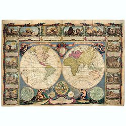
Mappe Monde, contenant les Parties Connues du Globe Terrestre
This beautiful wall map consists of two hemispheres. The Eastern Hemisphere is being carried by Hercules (with the skin of the Nemean Lion), the Western Hemisphere is car...
Place & Date: Paris, 1788
Selling price: $8200
Sold in 2021
Descrizione della fortezza, e città di Belgrado.
Scarce publication printed just before the Austrian attack to Beograde in 1789. The print is divide in three parts called « Prospetto della fortezza e parte della città...
Place & Date: Venice, 1788
Selling price: $900
Sold in 2019
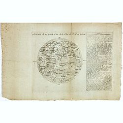
Reduction de la grande Carte de la Lune de J. Dom. Cassini.
The reduction of Cassini IV's reissue of his great-grandfather's rare and "elegant" lunar map. Jean-Dominique Cassini, known as Cassini IV (1748-1845), was born...
Place & Date: Paris, 1788
Selling price: $2400
Sold in 2019
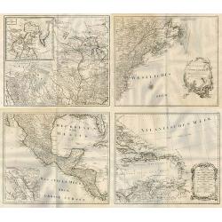
LES ETATS UNIS DE L' AMERIQUE SEPTENTRIONALE. Partie Occidentale.
A detailed map of the region bounded by New England, Florida, Mississippi river, Louisiana and Great Lakes of Canada. Includes towns, mountains, rivers, lakes, Indians, F...
Place & Date: Paris, 1788
Selling price: $350
Sold in 2019
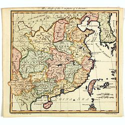
A Map of the Empire of China.
An attractive and uncommon map of China from Trusler's multi-volume work, "The Habitable World Described". In his Description of China, Trusler relied on the wr...
Place & Date: London, 1788
Selling price: $125
Sold in 2020
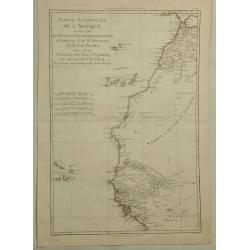
Partie Occidentale de L'Afrique. . .
A map of the north-western coast of Africa including the Canary Islands, by Bonne and Desmarest, published in the 1787 “Atlas Encyclopedique.”Rigobert Bonne (1727–1...
Place & Date: Paris, 1788
Selling price: $24
Sold in 2019
General Karte von Nord America samt den Westindischen Inseln Verfasst von Herrn Pownall.
A monumental map of North America, depicted shortly after the American Revolution. Printed on four sheets, not joined. Insets: Baffin & Hudson Bay. Engraver: J. Steng...
Place & Date: Wien, 1788
Selling price: $575
Sold in 2019
![[Title page] Allgemeiner Grosser Atlass . . .](/uploads/cache/45001-250x250.jpg)
[Title page] Allgemeiner Grosser Atlass . . .
Title page of Grosser Atlass. Franz Anton Schraemble (1751-1803), was a Austrian cartographer. He is well known for his "Allgemeiner deutscher Atlas aller Länder&qu...
Place & Date: Vienna, ca. 1788
Selling price: $80
Sold in 2023
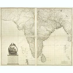
Neueste Karte von Hindostan, Bengalen etc. . .
Wall map of the Indian sub-continent after James Rennell, with large title cartouche of Britannia, native figures, a soldier and a merchant. Published by F. A. Schraembl...
Place & Date: Vienna, 1788
Selling price: $700
Sold in 2019
Australia, Van Diemen's Land, New South Wales, Queensland; Bonne / Desmarest - N.lle Galles Merid.le ou Cote Orientale de la Nouvelle Hollande . . .
Five maps in one sheet, showing coasts and natural ports of Australia. Folded as issued.
Place & Date: Paris, 1788
Selling price: $45
Sold in 2020
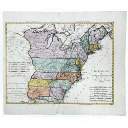
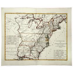
Les Etats-Unis de L'Amerique Septentrionale.
A detailed map of the region bounded by New England, Florida, Mississippi river, Louisiana and the Great Lakes of Canada. Includes towns, mountains, rivers, lakes, Indian...
Place & Date: Paris, 1788
Selling price: $250
Sold in 2020
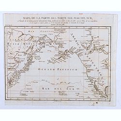
Mapa de la Parte del Norte del Mar del Sur, Sacado Dela Carta General Llamada de Cook, Publicada en Paris el Año de 1785. . .
Map of the Northern Part of the Pacific Ocean, taken from the "General Letter of Cook's Call. Published in Paris in the Year of 1785. With the Work of his Expedition...
Place & Date: Madrid, 1788
Selling price: $60
Sold in 2020
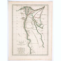
Egypt, Called in the Language of the Country Missir drawn from D'Anville's Atlas.
A map of Egypt after the French cartographer d'Anville, showing the Nile from source, south to Aswan. Quite detailed either side of the Nile and up in the Nile Delta to t...
Place & Date: London, 1788
Selling price: $11
Sold in 2020
L'Africa divisa nelle sue principali parti.
A rare Italian map, published by Carli Pazzini in Siena. It shows the African continent with place names along the coasts, but large blank interior parts. Curious large l...
Place & Date: Siena, 1788
Selling price: $210
Sold in 2020
Mappe-Monde, sur le plan de l'Equateur, Hemisphere Septentrional.
An attractive small double-page hemisphere map on a (north) polar projection from the North Pole down to the Equator. From the Atlas Encyclopédique contenant la Géograp...
Place & Date: Paris, 1788
Selling price: $75
Sold in 2021
Carte de L'Isle de Sainte Lucie. Dressee au Depost des Cartes et Plans de la Marine. . .
A well engraved and highly detailed nautical chart of the island of Saint Lucia in Caribbean. It shows soundings, anchorage's, channels, shoals, navigational sightings. U...
Place & Date: Paris, 1788
Selling price: $250
Sold in 2021
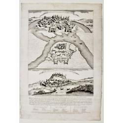
Plan de la Baye d'Awatska sur la Cote du Kamschatka
An interesting map of several countries along the east coast of Asia. In addition to Kamchatka, it includes Partie du Japon ou Nippon, Plan du Typa ou de Macao, Plan du H...
Place & Date: Paris, 1788
Selling price: $15
Sold in 2023
A New & Accurate Chart of the Western or Atlantic Ocean.
A map from 'Middleton's Complete System of Geography', from the Arctic Ocean in the north, south to the top of South America and across to the Slave Coast of Africa. Fro...
Place & Date: London, 1788
Selling price: $43
Sold in 2021
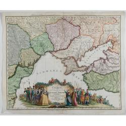
Charte von den oberhalb und seitwärts dem Schwarzen Meere gelegenen Russischen und Türkischen Ländern …
Very rare and detailed map of the black sea region, including parts of Ukraine, Turkey and Poland. In the lower part, a color key. Beautiful tittle cartouche with Empress...
Place & Date: Berlin, 1788
Selling price: $1500
Sold in 2023