Browse Listings
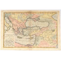
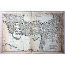
La Turquie d'Europe et Celle D'Asie.
A fine example of Rigobert Bonne and Guilleme Raynal's 1780 map of Turkey in Europe and Asia. This map of the Ottoman Empire includes the areas stretching from Italy, Hun...
Date: Paris, c1780
Selling price: ????
Please login to see price!
Sold in 2016
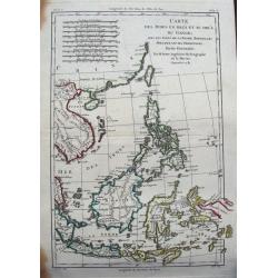
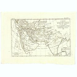
Carte des Indes en deçà et au delà du Gange...
Detailed 18th century map of the Philippines, Borneo, and parts of Indonesia from the Strait of Singapore to New Guinea. Includes also Formosa (Taiwan) and Hainan. A deta...
Date: Paris, ca. 1780
Selling price: ????
Please login to see price!
Sold in 2015
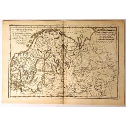
Le Nord de L'Europe
A fine map of Northern Europe and European Russia. It covers the modern day countries of Norway, Sweden, Finland, Denmark, and Finland as well as parts of Russia (includi...
Date: Paris, 1780
Selling price: ????
Please login to see price!
Sold in 2015
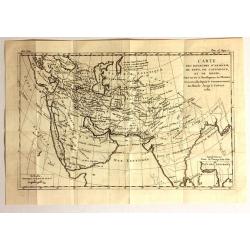
Carte des Royoumes d'Armenie, de Pont, de Cappadoce et de Medie
Fine copper engraved engraving featuring the Middle East and Asia by Brion de la Tour, and published in "HISTOIRE UNIVERSELL" by Chez Moutard.
Date: Paris, 1780
Selling price: ????
Please login to see price!
Sold in 2015
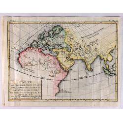
Partie Occidentale de L'Ancien Continent.
"Western part of the old continent, from Lisbon to the river Sierra Leona, etc." Antique map from the "Atlas de Toutes les Parties Connues du Globe Terrest...
Date: Paris, 1780
Selling price: ????
Please login to see price!
Sold in 2017
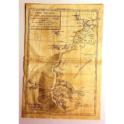
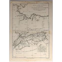
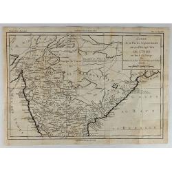
Carte de la Partie Septentrionale d'Afrique ou de la Barbarie.
A fine map of North Africa on the Mediterranean Sea. Containing the kingdoms of Tripoli, Tunis, of Algiers, Fez and Morocco.
Date: Paris, 1780
Selling price: ????
Please login to see price!
Sold in 2015

Habits des Negres du Cap Verd. / Kleedy der Negers aan Kabo Verde.
Inhabitants of Cape Verde.
Date: Paris, Didot, ca. 1780
Selling price: ????
Please login to see price!
Sold in 2017
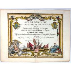
Atlas Portatif des Militaires et des Voyageurs. Tome 2e
A fine title page featuring two female figures around a group of flags. Father time looks in from the left side.The atlas is dedicated to the King, and was published at C...
Date: Paris, 1780
Selling price: ????
Please login to see price!
Sold in 2017
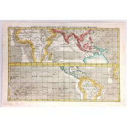
Carte de la Direction des Vents Generaux dt des Moussons.
A very interesting chart that shows the direction of the trade winds and monsoons. Comprised of two charts of the world, one on each side of the equator. The upper map sh...
Date: Paris, 1780
Selling price: ????
Please login to see price!
Sold in 2017
Carte du Kamtchatka Dressee et Gravee par Laurent.
A striking copper engraved map of the peninsula of Kamtchatka in Eastern Russia, with excellent detail of the topography. Numerous roads and settlements are located. The ...
Date: Paris, 1780
Selling price: ????
Please login to see price!
Sold in 2016
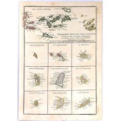
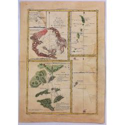
Supplement Pour Les Isles Antilles, Extract des Cartes Angloises
At the top of this interesting group of maps are the Virgin Islands, and below them are nine small maps of Barbuda, Barbados, St Vincent, St. Kitts, Antigua, Dominica, Sa...
Date: Paris, 1780
Selling price: ????
Please login to see price!
Sold in 2017
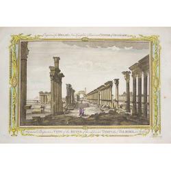
‘A General Perspective View of the Ruins of the celebrated Temple of Palmira in Arabia'
Engraved by John Lodge, and published in Millar's New Complete & Universal System of Geography.This engraving shows the ruins of the 2,000 year old Temple of Palmyra,...
Date: London, 1780
Selling price: ????
Please login to see price!
Sold in 2016
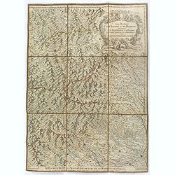
Les duchés de Savoye, de Genevois, de Chablais, les comtés de Maurienne, de Tarentaise et la baronie de Faucigny, le bailliage de Gex et la Seigneurie de Genève.
Uncommon folding case map showing the region of Pays de Gex et le Genevois, le Chablais et le Faucigny, la Savoie, la Maurienne et la Tarentaise. Prepared by H.Jaillot an...
Date: Paris, ca. 1780
Selling price: ????
Please login to see price!
Sold in 2016
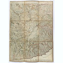
Les Estats de Savoye et de Piémont. Le Dauphiné, la Bresse partie de Linois et de la Provence
Uncommon folding case map showing the region of Pays de Gex et le Genevois, le Chablais et le Faucigny, la Savoie, la Maurienne et la Tarentaise. Prepared by H.Jaillot an...
Date: Paris, ca. 1780
Selling price: ????
Please login to see price!
Sold
La Principauté de Piémont, les Marquisatsde Saluce et de Sueze, les Comtés de Nice et d'Ast, le Montferrat.
Uncommon folding case map showing the region of Pays de Gex et le Genevois, le Chablais et le Faucigny, la Savoie, la Maurienne et la Tarentaise. Prepared by H.Jaillot an...
Date: Paris, ca. 1780
Selling price: ????
Please login to see price!
Sold in 2016
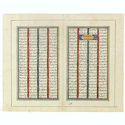
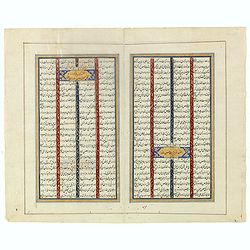
Double page manuscript page with Islamic prayers with beautiful headings throughout.
Fine double page brilliantly illuminated gilt leaves written by the scribe Abu Bakr Jami in Isfahan. The Arabic text contains Islamic prayers with beautiful headings thro...
Date: Isfahan, ca. 1780
Selling price: ????
Please login to see price!
Sold in 2016
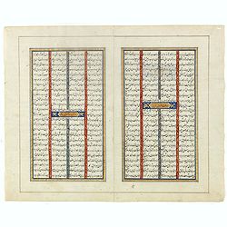
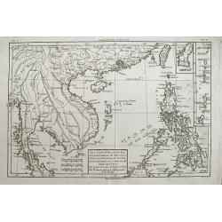
Les Isles Philippines, celle de Formose, le sud de la Chine,...
A very interesting map of the South China Sea and the Philippines. Highly detailed with numerous places and islands named.Extends from Pegu and Thailand to Taiwan, and so...
Date: Paris, c1780
Selling price: ????
Please login to see price!
Sold in 2016
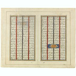
Double page manuscript page from a Shahnameh, The Book of Kings, written by Ferdowsi.
Fine double page brilliantly illuminated gilt leaves written by the scribe Abu Bakr Jami in Isfahan. The Arabic text contains Islamic prayers with beautiful headings thro...
Date: Isfahan, ca. 1780
Selling price: ????
Please login to see price!
Sold in 2016
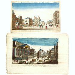
Two opticals of London.
Two optical prints of London, being : "Vue de l'Hotel Royal des Gardes du Corps a pied vis a' vis la Salle Blanche a manger a Londres" and "Vue de L'Hotel ...
Date: Paris c.1780
Selling price: ????
Please login to see price!
Sold in 2016
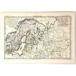
Le Nord de L'Europe...
A fine map of Northern Europe and European Russia. It includes present day Norway, Sweden, Denmark, Finland and parts of Russia, by Rigobert Bonne for G. Raynal’s “AT...
Date: Paris, 1780
Selling price: ????
Please login to see price!
Sold in 2018
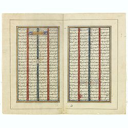
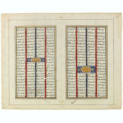
Double page manuscript page from a Shahnameh, The Book of Kings, written by Ferdowsi.
Fine double page brilliantly illuminated gilt leaves written by the scribe Abu Bakr Jami in Isfahan. The Arabic text contains Islamic prayers with beautiful headings thro...
Date: Isfahan, ca. 1780
Selling price: ????
Please login to see price!
Sold in 2022
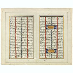
Double page manuscript page from a Shahnameh, The Book of Kings, written by Ferdowsi.
Fine double page brilliantly illuminated gilt leaves written by the scribe Abu Bakr Jami in Isfahan. The Arabic text contains Islamic prayers with beautiful headings thro...
Date: Isfahan, ca. 1780
Selling price: ????
Please login to see price!
Sold in 2020
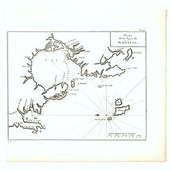
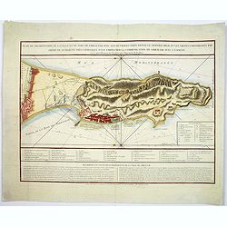
Plan de la Baye de Manille.
Detailed plan of Manila Bay engraved by Jean Lattré after Anson's key plan of the Bay of Manila. With a compass rose and soundings in the Bay.
Date: Paris, c.1780
Selling price: ????
Please login to see price!
Sold in 2016
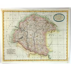
Hungary with Part of the Adjoining Principalities &c.
A fine late 18th century copper engraved map of Hungary and Romania published in 'Barlow's General History of Europe'.Thomas Bowen was an English engraver of charts. He w...
Date: London, 1780
Selling price: ????
Please login to see price!
Sold in 2016
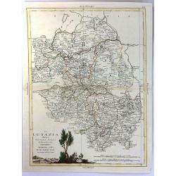
La Lusazia Divisa Nesuoi stati de Nuova Projezione
Lusatia is a historical region between the rivers Bóbr (a tributary of the Oder ) and Kwisa, and the River Elbein Saxony, in Germany, the Eastern Atlantic and Brandenbur...
Date: Venice, 1780
Selling price: ????
Please login to see price!
Sold in 2016
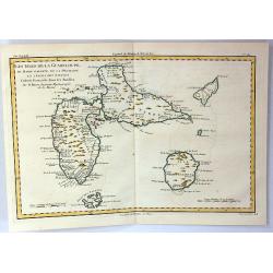
Les Isles de la Guadeloupe de Marei Galante, de la Desirade et Celles des Saintes.
A map of the French island of Guadeloupe with the islands in the vicinity. Many towns and forts are named, and some topographical details (mountains, rivers, lakes...), a...
Date: Paris, 1780
Selling price: ????
Please login to see price!
Sold in 2019
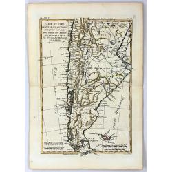
Carte du Chili Depuis le Sud du Perou Jusqu'au Cap Horn
A fine example of Rigobert Bonne and Guillaume Raynal's 1780 map of Chile. Covers modern day Chile, Argentina, Uruguay, the Falkland Islands, Tierra del Fuego, and Cape H...
Date: Paris, 1780
Selling price: ????
Please login to see price!
Sold in 2016

Vue de la Pondichery dans les Indes Orientales
Pondicherry is the capital city of Indian union territory of Puducherry. Pondicherry is situated in Puducherry district of the union territory in India. The vue was produ...
Date: Paris, 1780
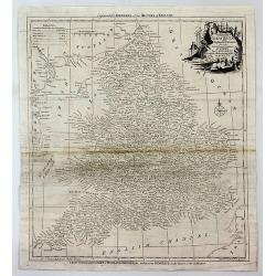
Cumberland drawn from the best surveys,...
An attractive and finely engraved 18th century map of Cumberland. Main cities are shown connected with roads. Borough towns and market towns are indicated, as well as par...
Date: London, ca. 1780
Selling price: ????
Please login to see price!
Sold in 2016
Carte des Royaumes d'Armenie. de Pont, de Cappadoce, et de Medie...
An ancient map by the French cartographer Rigobert Bonne, showing the Arabian peninsular, the eastern Mediterranean, Persia, India, and the countries surrounding the Casp...
Date: Paris, 1780
Selling price: ????
Please login to see price!
Sold in 2017
Plan du promontoire de la ville et du port de Gibraltar avec les ouvrages faits depuis le dernier siège. . .
Published in Paris, this attractive map of Gibraltar, on the very tip of the Iberian Peninsula, includes a wealth of information, much of it concerning the Spanish siege ...
Date: Paris, ca 1780
Selling price: ????
Please login to see price!
Sold in 2017
![Plans Particuliers dépendans de l'Isle-Royale. . . [5 inset charts on one sheet]](/uploads/cache/39159-250x250.jpg)
Plans Particuliers dépendans de l'Isle-Royale. . . [5 inset charts on one sheet]
Five sea charts on one sheet "Plan du port et des isles au juste au corps. Together with "Plan de la baie de Morienne", and "Plan de la rade et de la ...
Date: Paris, ca.1780
Selling price: ????
Please login to see price!
Sold in 2018
Carte réduite de L'Ile Royale, assujettie aux observations astronimiques et nautiiques. . . le Marquis de Chabert. . .
Sea chart of the rade of St.Anne. Published in "Neptune Americo-Septentrional" at the time of the American Revolution. According to the title prepared by Antoin...
Date: Paris, ca.1780
Selling price: ????
Please login to see price!
Sold in 2017
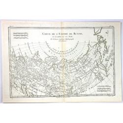
Carte de L'Empire de Russie
An example of Rigobert Bonne and Guillaume Raynal's 1780 map of the Russian Empire. It shows the entire Russian Empire stretching from Europe to the Behring Strait, as we...
Date: Paris, 1780
Selling price: ????
Please login to see price!
Sold in 2017
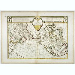
Carte des nouvelles decouvertes au Nord de la Mer du Sud.
The Dezauche edition of Joseph De L'Isle map concentrating on the northern Pacific and showing all of North America and Mexico. While the Russian coastline is shown with ...
Date: Paris, Dezauche, 1780
Selling price: ????
Please login to see price!
Sold in 2023
![[Bound collection of 22 maps in Italian after Bowen]](/uploads/cache/39408-250x250.jpg)
[Bound collection of 22 maps in Italian after Bowen]
The only recorded example of this bound collection of 22 maps in Italian, copied after Emanuel Bowen and given credit in the cartouches. The maps have extensive text pane...
Date: Italy, ca. 1780
Selling price: ????
Please login to see price!
Sold
Set of Three Bible Engravings by Condor.
A set of 3 bible copper engravings from "Mr. Priestley's Evangelical Family Bible". Two of the maps have two maps on one sheet so there are a total of four maps...
Date: London, ca. 1780
Selling price: ????
Please login to see price!
Sold in 2017
Accurate Map of That District of Great Britain Called England & Wales...
A very detailed map of Great Britain by Thomas Kitchin, from Walpoole's New & Complete British Traveller, published in 1784.The map shows the counties and identifies ...
Date: London, ca. 1780
Selling price: ????
Please login to see price!
Sold in 2017
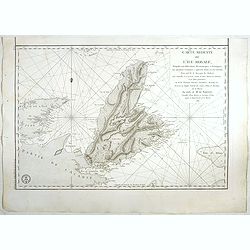
Bottom Part Only of Huge Map centering on Greece.
A large bottom portion of a huge map centering on Greece. The original map was about 41" x 32".This section covers the area between Libya and Iraq on the south ...
Date: Anon, ca. 1780
Selling price: ????
Please login to see price!
Sold in 2017
Plan de Bergame.
Bergamo (Bergame) is an Italian town, the capital of the province of the same name, located in Lombardy. It is about 50 km north-east of Milan. This plan by Jerome de la ...
Date: Paris, ca. 1780
Selling price: ????
Please login to see price!
Sold in 2018
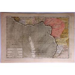
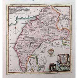
Carte de la Haute et de la Basse Guinee Depuis la Riviere de Sierra Leona Jus qu' au Cap Negro.
A fine map of Africa's Guinea coast by Rigobert Bonne and G. Raynal's in 1780. The map corresponds to modern day Liberia, Ivory Coast, Ghana, Nigeria, Cameroon, Gabon, Co...
Date: Paris, 1780
Selling price: ????
Please login to see price!
Sold in 2017
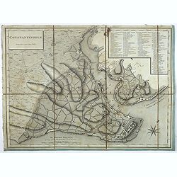
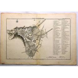
Constantinople.
Plan of Constantinople engraved by Tardieu, decorated with a rose of the winds. The names on the plan are written in Turkish, the key (1 - 86) in French.
Date: Paris, 1780
Selling price: ????
Please login to see price!
Sold in 2023
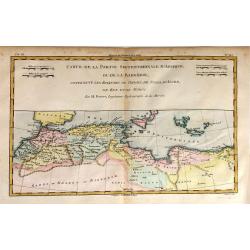
Etats du Roi de Maroc. Les Royaumes D'Algier, de Tunis et de Tripoli, avec les Pays Circonvoisins.
A North African map of Algeria, Tunisia, and Tripoli by Raynal and Bonne in 1780. It is from Atlas of All Known Parts of Globe, Lists For Philosophical History and Polic...
Date: Paris, 1780
Selling price: ????
Please login to see price!
Sold in 2018
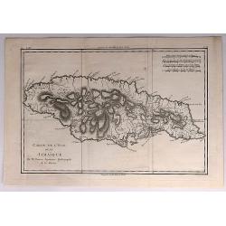
Carte de L'Isle de la Jamaique.
A fine map of the Island of Jamaica. A good example of Rigobert Bonne and Guilleme Raynal's 1780 map of Jamaica. Detailed, with towns, rivers, some topographical features...
Date: Paris, 1780
Selling price: ????
Please login to see price!
Sold in 2018
Plan du Typa ou de Macao, Plan de la Baye D'Awatska, Partie du Japon.
A pleasing copper engraving with separate detailed maps of Kamchatka, part of Japan, and the Island of Macao. The Kamchatka map includes an inset: “Plan du Havre de St....
Date: Paris, 1780
Selling price: ????
Please login to see price!
Sold in 2018
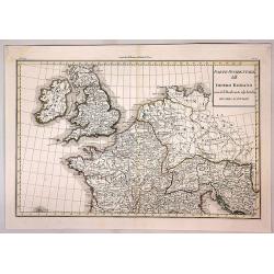
Parte Occidentale dell Impero Romano ....
The western part of the Ancient Roman Empire by Anville. It covers the areas of England (Bretagna), Ireland (Hybernia), France (Gallia) and Germania.Jean Baptiste Bourgu...
Date: Paris, ca. 1780
Selling price: ????
Please login to see price!
Sold in 2017
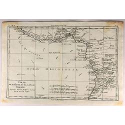
Carte de la Haute et de la Basse Guinee.
An engraved map showing the entire Guinea coast from the Sierra Leone River to Cape Negro. Locates many towns and villages, lakes and coastal features. Today this is Libe...
Date: Paris, 1780
Selling price: ????
Please login to see price!
Sold in 2019
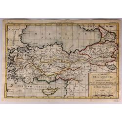
Carte de L'Anadoli et Autres Provinces de la Turquie Asiatique...
A striking, copper engraved map of Anatolia. The map covers Turkey, Armenia, Cyprus, a bit of Georgia, the northern tip of Syria, and the coast of Romania. The map provid...
Date: Paris, 1780
Selling price: ????
Please login to see price!
Sold in 2017

Frontispiece to Vol. III. of Howard's New Encyclopaedia or Complete Dictionary of Arts & Sciences.
A large and very interesting title page, filled with artists, scientists, etc. Includes a model of planet constellations, a map, musical instruments, and many more object...
Date: London, ca. 1780
Selling price: ????
Please login to see price!
Sold in 2017
Bybelsche Huis en Zak-Atlas....
Unusual atlas with a few pages of text followed by 15 copper-engraved folding maps of areas in the Near East, Arabia, Turkey, and northern Africa: 1) Kaart van de Oude W...
Date: Amsterdam, ca. 1780
Selling price: ????
Please login to see price!
Sold in 2017
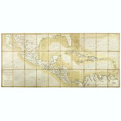
Carte des Isles Antilles et du Golfe du Mexique, avec la Majeure partie de la Nouvelle Espagne. Par M. Bonne, Inge´nieur Hydrographe de la Marine. Aoust 1780. . .
The first edition of this scarce large format map of Florida, the Gulf Coast, Texas (almost to Corpus Christi), Mexico, Baja California and Central America, northern Sout...
Date: Paris, 1780
Selling price: ????
Please login to see price!
Sold in 2022

Vue Perspective de la Place des Victoires.
Optical print of Place des Victoires in Paris.
Date: Paris, 1780
Selling price: ????
Please login to see price!
Sold in 2018
Vue General du Chateau de Monseigneur le Duc de Richelieu en Poitou.
Optical print of Place des Victoires in Paris. Basset was a well-known publisher of optical prints, established in rue St Jacques in Paris. In the 18th century the optica...
Date: Paris, 1780
Selling price: ????
Please login to see price!
Sold in 2018
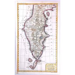
Carte de la Partie Septentrionale de la Presqu'ile de L'Inde...
Striking map of central and northern India showing rivers, mountains, towns and cities, including Bombay. Beneath the title cartouche, the Bouches du Gange ("Mouth...
Date: Paris, 1780
Selling price: ????
Please login to see price!
Sold in 2018
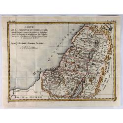
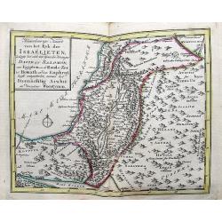
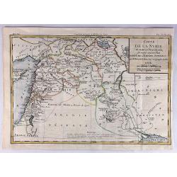
Carte de la Palestine ou Terre Sainte.
A pleasant map of the Holy Land from Sidon to Gaza and inland to the Arabian Desert. The map is divided into the Tweve Tribes and a key identifies royal villages and Levi...
Date: Paris, 1780
Selling price: ????
Please login to see price!
Sold in 2019
Carte de la Syrie et Autres Provinces Formant Aujourd'hui Partie de L'Empire Ottoman.
A fine map of Syria and other regions including; Roum, Irakarabia, Khosistan, Armemia, Kurdistan and Palestine. Also shown is most of the island of Cyprus. Louis Brion de...
Date: Paris, 1780
Selling price: ????
Please login to see price!
Sold in 2020
Carte des Transmigrations et des Etablissemens de Celtes ou Comerites et des Scythes.
An interesting map of transmigrations and establishments of the Celts and the Scythians. It includes Europe, North Africa and Western Asia.Louis Brion de la Tour (1756-18...
Date: Paris, 1780
Selling price: ????
Please login to see price!
Sold in 2020
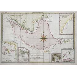
CARTE DE L'ISLE DE GRAND JAVA.
A scarce copperplate hand colored map of the island of Java. It shows the island upside down with the north to the bottom. Divided by regions with names of territories, s...
Date: Paris, ca. 1780
Selling price: ????
Please login to see price!
Sold in 2020
Missiion des Moxes Etablie par les PP de la Comp'e de Jesus dans le Perou.
A fine detailed map of Peru showing the topographical locations and details of the many Jesuit missions. It features an attractive title cartouche.
Date: Paris, 1780
Selling price: ????
Please login to see price!
Sold in 2017
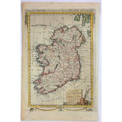
A New and Correct Map of Ireland from the Latest Surveys of That Kingdom.
A fine detailed map of Ireland by John Hamilton Moore in London in 1780. It is from "MOORE'S NEW AND COMPLETE COLLECTION OF VOYAGES AND TRAVELS". Engraved for B...
Date: London, 1780
Selling price: ????
Please login to see price!
Sold in 2019
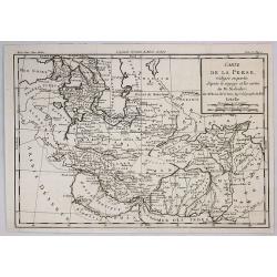
Carte de la Perse Redigee en Partie d'Apres le Voyage et les Cartes de M. Niebhr.
An interesting detailed map of the region stretching from the Caucasus through Afghanistan and the Arabian Desert to the Indus River. By Brion de la Tour in Paris in 1780...
Date: Paris, 1780
Selling price: ????
Please login to see price!
Sold in 2018
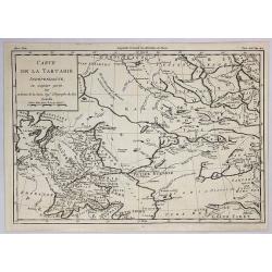
Carte de la Tartarie Independante. . .
An interesting detailed map of the region stretching from Khorasan to Grand Tibet and north to Siberia. By Brion de la Tour in Paris in 1780. From Historie Universale.Lou...
Date: Paris, 1780
Selling price: ????
Please login to see price!
Sold in 2019
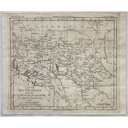
Carte des Provinces Annexees a la Petite Pologne et de la Gallicie avec la Lodomerie Demembrees de la Pologne.
An interesting regional map of Poland and Lithuania, extending from the Karpathian Mountains and Bessarabia to Kiev on the Dniepr, Brescz on the Bug and centered on the p...
Date: Paris, 1780
Selling price: ????
Please login to see price!
Sold in 2018
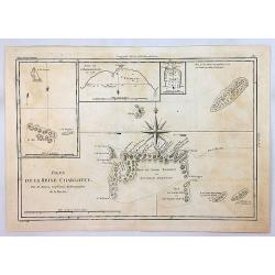
Isles de la Reine Charlotte.
An antique map showing the Queen Charlotte Islands after Captain Cook's voyages of 1778 and 1779, by Bonne in Paris, published in the 1787 Atlas Encyclopedique. Includes...
Date: Paris, 1780
Selling price: ????
Please login to see price!
Sold in 2018
Extrémité Meridionale De Amérique.
Map shows Tierra del Fuego, with 5 inset maps of Canal de Noel, Terre de Feu, Bay Dubon, and the coast.Rigobert Bonne (1727–1795) was one of the most important cartogra...
Date: Paris, ca. 1780
Selling price: ????
Please login to see price!
Sold in 2018
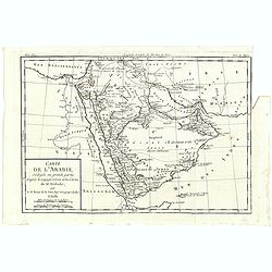
Carte de L'Arabie, rédigée en grande partie d'après le voyge récent et les Cartes de M. Niebuhr par le Sr. Brion de la Tour. . .
Map giving good detail of the Arabian peninsula. From "Histoire Universel" by Louis Brion de la Tour.
Date: Paris, 1780
Selling price: ????
Please login to see price!
Sold in 2021
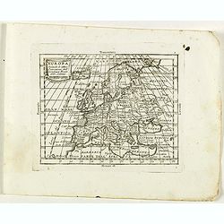
Europa secondo le ultime osservazioni dell' Academia reala delle Scienze.
Rare map of Europe, from "Atlante Novissimo ad uso Dei Giovani Studiosi Contenuto In Carte XXVII.", published by Giovanni Zempel in Rome, ca. 1780.The map is ba...
Date: Rome, 1780
Selling price: ????
Please login to see price!
Sold in 2022
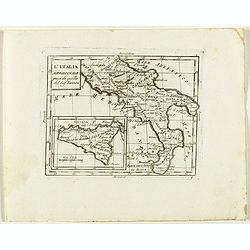
L'Italia Meridionale presa da quella del Sig. Zannomi.
Rare map of Southern part of Italy with inset of Sicily, from "Atlante Novissimo ad uso Dei Giovani Studiosi Contenuto In Carte XXVII.", published by Giovanni Z...
Date: Rome, 1780
Selling price: ????
Please login to see price!
Sold in 2018
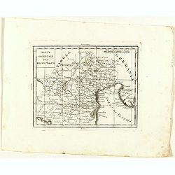
Parte Orientale del Regno Italico.
Rare map of north western Italy with Trieste region and Venice and it's bay, from "Atlante Novissimo ad uso Dei Giovani Studiosi Contenuto In Carte XXVII.", pub...
Date: Rome, 1780
Selling price: ????
Please login to see price!
Sold in 2022
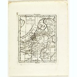
Li Paesi Bassi di Nuova Projezione.
Rare map of the Netherlands, from "Atlante Novissimo ad uso Dei Giovani Studiosi Contenuto In Carte XXVII.", published by Giovanni Zempel in Rome, ca. 1780.The ...
Date: Rome, 1780
Selling price: ????
Please login to see price!
Sold in 2018
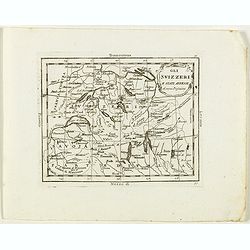
Gli Svizzeri e stati Anessi di nuova Projezione.
Rare map of Switzerland, from "Atlante Novissimo ad uso Dei Giovani Studiosi Contenuto In Carte XXVII.", published by Giovanni Zempel in Rome, ca. 1780.The map ...
Date: Rome, 1780
Selling price: ????
Please login to see price!
Sold in 2018
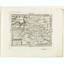
Polonia Secondo le Osservazioni dell' Accademia di Parigi.
Rare map of Poland, from "Atlante Novissimo ad uso Dei Giovani Studiosi Contenuto In Carte XXVII.", published by Giovanni Zempel in Rome, ca. 1780.The map is ba...
Date: Rome, 1780
Selling price: ????
Please login to see price!
Sold in 2019
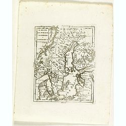
Li regni di svezia Norvegia e Danimarca.
Rare map of Scandinavia, from "Atlante Novissimo ad uso Dei Giovani Studiosi Contenuto In Carte XXVII.", published by Giovanni Zempel in Rome, ca. 1780.The map ...
Date: Rome, 1780
Selling price: ????
Please login to see price!
Sold in 2018
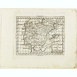
La Spagna e Portogallo.
Rare map of Spain and Portugal, from "Atlante Novissimo ad uso Dei Giovani Studiosi Contenuto In Carte XXVII.", published by Giovanni Zempel in Rome, ca. 1780.T...
Date: Rome, 1780
Selling price: ????
Please login to see price!
Sold in 2019
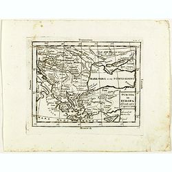
Turchia in Europa . . .
Rare map of Black Sea with Greece and Turkey, from "Atlante Novissimo ad uso Dei Giovani Studiosi Contenuto In Carte XXVII.", published by Giovanni Zempel in Ro...
Date: Rome, 1780
Selling price: ????
Please login to see price!
Sold in 2020
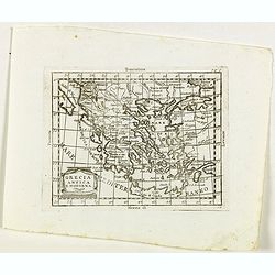
Grecia Antica e Moderna.
Rare map of Greece, from "Atlante Novissimo ad uso Dei Giovani Studiosi Contenuto In Carte XXVII.", published by Giovanni Zempel in Rome, ca. 1780.The map is ba...
Date: Rome, 1780
Selling price: ????
Please login to see price!
Sold in 2020
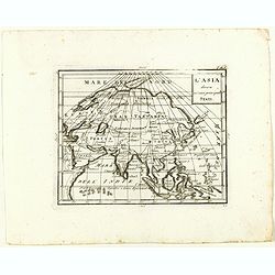
L'Asia divisa ne' suoi principali stati.
Rare map of Asia, from "Atlante Novissimo ad uso Dei Giovani Studiosi Contenuto In Carte XXVII.", published by Giovanni Zempel in Rome, ca. 1780.The map is base...
Date: Rome, 1780
Selling price: ????
Please login to see price!
Sold in 2018

