Browse Listings
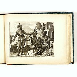
Habillemens de plusieurs nations représentez au naturel, en cent trente-sept belles figures.
Illustrated with a title page and 132 engraved plates of costumes (of 136) not following the numbering but grouped by countries.The plates showing various nations from al...
Date: Leiden, Pierre van der Aa, c. 1720
Selling price: ????
Please login to see price!
Sold in 2018
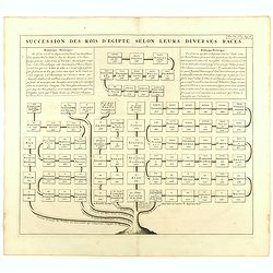
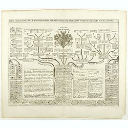
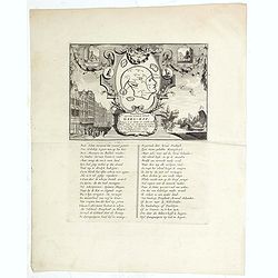
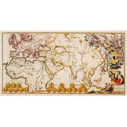
Succession des Rois d'Egipte selon leurs diverses races.
Genealogical tree, showing the Kings of Egypt.Zacharie Chatelain (d.1723) was the father of Henri Abraham (1684-1743) and Zacharie Junior (1690-1754).They worked as a par...
Date: Amsterdam, ca. 1720
Selling price: ????
Please login to see price!
Sold in 2023
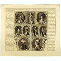
Habillemens des Dames.. Constantinople.. Serrail..
This beautiful copper-engraving containing 7 engravings of native female and 3 males of Istanbul. From Chatelain's monumental 7 volume "Atlas Historique". Henri...
Date: Amsterdam, 1720
Selling price: ????
Please login to see price!
Sold in 2018
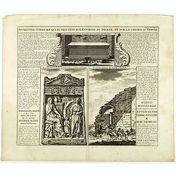
Antiquez curieuses qui se trouvent aux environs de Smyrne, et sur le chemin d'Ephese.
Folio sheet describing and depicting ancient Greek monuments and ruins in Smyrna (Izmir). From Chatelain's monumental 7 volume "Atlas Historique". Henri Abraham...
Date: Amsterdam, 1720
Selling price: ????
Please login to see price!
Sold in 2020
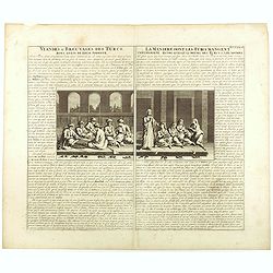
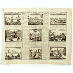
Viandes & breuvages des Turcs . . . / La manière dont les Turcs mangent . . .
Interesting sheet with a detailed views illustrating the lunch time in turkey, with descriptive French text, from Chatelain's monumental 7 volume Atlas Historique. In upp...
Date: Amsterdam, ca. 1720
Selling price: ????
Please login to see price!
Sold in 2018
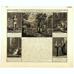
Mariage des Turcs & des Armeniens, avec la ma niere dont se font les demonstrations d'amour . . .
Showing the marriage rituals and lives of Turks and Armenians. Five engravings set round a text panel in French. From Chatelain's monumental 7 volume "Atlas Historiq...
Date: Amsterdam, 1720
Selling price: ????
Please login to see price!
Sold in 2025

Portraits du Moufti & autres Gens de Loi de l'Empire Ottoman . . .
Four full-length portraits of Turkish costumes, each with a descriptive engraved text: a Mufti, an scholar of Islamic law. An Emir, a commander, here described as a desce...
Date: Amsterdam, 1720
Selling price: ????
Please login to see price!
Sold in 2025
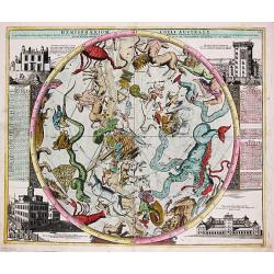
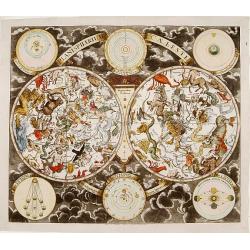
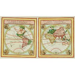
Hemisphaerium Coeli Australe.
Johan Baptist Homann (1663-1724). was an outstanding German cartographer. He was the founder of the Homann publishing house. After the death of the son Johann Christoph, ...
Date: Nürnberg, ca 1720
Selling price: ????
Please login to see price!
Sold in 2019
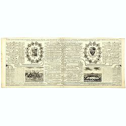
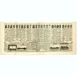
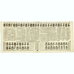
Carte Genealogique de la Maison Imperiale d'Autriche & les Differentes Branches qu'elle a Formees Accompagnee des Trophees des Armes Imperiales & d'Espagne ...
An engraved genealogical family tree of Imperial Austria illustrating its links with the Spanish royal family. Their respective arms dominate the plate with views of the ...
Date: Amsterdam, ca. 1720
Selling price: ????
Please login to see price!
Sold in 2018
Carte genealogique de la maison des Valois. . .
Ornamented with numerous vignettes representing Place Royal, Palais des Tuilleries and Palais du Luxembourg in Paris.Exhaustive information about the settlements is given...
Date: Amsterdam, ca. 1720
Selling price: ????
Please login to see price!
Sold in 2022
Regnum Borussiae gloriosis auspiciis serenissimi et potentissimi princip. Friderici III primi Borussiae regis march. et elect. Brandenburg inauguratum die 18 Jan...1701.
Map covering the region along the Baltic Sea from Prussia to northern Poland.Beautiful ornamental title cartouche in upper middle with later color addition. Centered on D...
Date: Nuremberg, 1720
Selling price: ????
Please login to see price!
Sold
Carte genealogique de la Maison de Savoye . . .
Fine example of Chatelain's attractive plate showing the genealogy of the Savoy House in France.Zacharie Chatelain (d.1723) was the father of Henri Abraham (1684-1743) an...
Date: Amsterdam, ca. 1720
Selling price: ????
Please login to see price!
Sold in 2018
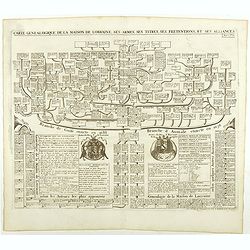
Carte genealogique de la Maison de Lorraine . . .
Fine example of Chatelain's attractive plate showing the genealogy of the Lorraine House in France.Zacharie Chatelain (d.1723) was the father of Henri Abraham (1684-1743)...
Date: Amsterdam, ca. 1720
Selling price: ????
Please login to see price!
Sold in 2018
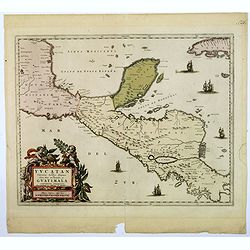
Yucatan conventus. . .Guatimala conventus. . .
A very handsome looking map, first published in 1662 by Blaeu, this later edition bears the imprint of Pierre Mortier. The map encompasses the area from Mexico City in th...
Date: Amsterdam, ca 1720
Selling price: ????
Please login to see price!
Sold in 2018
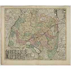
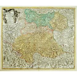
Nova Helvetiae tabula geographica . . .
Johann Jakob Scheuchzer (August 2, 1672 – June 23, 1733) was a Swiss scholar born at Zürich. In 1712 he published, a map of Switzerland in four sheets (scale 1/290,000...
Date: Amsterdam, 1720
Selling price: ????
Please login to see price!
Sold in 2020
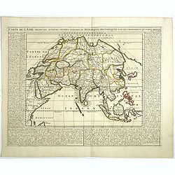
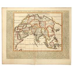
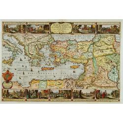
Carte de l'Asie selon les auteurs anciens enrichie de remarques historiques sur les changements qui y sont arrivez.
Map of Asia, extending from the Mediterranean, the Red Sea and the Saudi Arabian Peninsula to Japan, the Philippines and Southeast Asia. With explanatory text on either s...
Date: Amsterdam, 1720
Selling price: ????
Please login to see price!
Sold in 2018

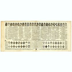
Carte généalogique de la maison de Plantagenette et des ducs Normandie . . .
Genealogical chart of medieval English royal families, seven coats of arms of Edward the Confessor, Edward III, the Plantagenets, the Duke of Normandy and others.Henri Ab...
Date: Amsterdam, 1720
Selling price: ????
Please login to see price!
Sold in 2022
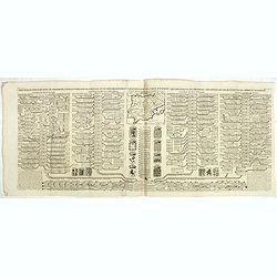
Carte Genealogique des Rois de Portugal & Partie des Differentes Branches qu'ils ont Formee avec le Blazon de leurs Armes & de leurs Alliances.
A genealogical tree of the Portuguese Kings with descriptive, from Chatelain's monumental 7 volume "Atlas Historique". Henri Abraham Chatelain (1684 – 1743) w...
Date: Amsterdam, 1720
Selling price: ????
Please login to see price!
Sold in 2018
Carte genealogique des des rois de France depuis Hugue Capet jusqu'à la famillede Valois . . .
Genealogical chart of kings of France, from Chatelain's monumental 7 volume "Atlas Historique". Henri Abraham Chatelain (1684 – 1743) was a Huguenot pastor of...
Date: Amsterdam, 1720
Selling price: ????
Please login to see price!
Sold in 2018

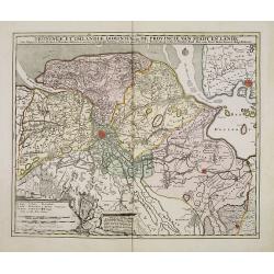
Carte Historique & Cronologique Pour Servir a L'Histoire des Provinces-Unis des Pais-Bas.
A wonderful genealogical chart and portraits of the rulers of the Netherlands, dating from Charles V in 1558 AD to William III of Orange, till 1702. From “Atlas Histori...
Date: Amsterdam, 1720
Selling price: ????
Please login to see price!
Sold in 2019
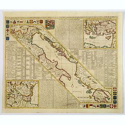
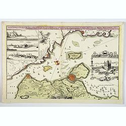
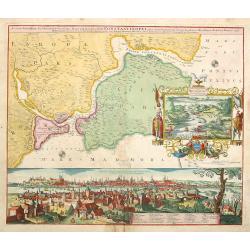
Carte de Géographie des différents Etats de la République de Venise . . .
An interesting map of the Gulf of Venice with inset map of the surroundings of Venice and map of Turkey in upper right corner. Plenty of descriptive French text, from Cha...
Date: Amsterdam, 1720
Selling price: ????
Please login to see price!
Sold in 2021
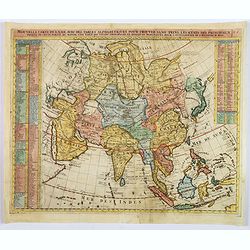
Nouvelle Carte de l'Asie avec des Tables Alphabetiques. . .
Full title: Nouvelle Carte de l' Asie avec des Tables Alphabetiques pour Trouver sans Peine les Etats des Principaux Princes de Cette partie du Monde. A fine map of Asia ...
Date: Paris, ca 1720
Selling price: ????
Please login to see price!
Sold in 2019
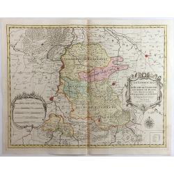
Le Limbourg, Le Duche de Limbourg, Le Comte de Dalem, Les Seigneures de Fauquemont et de Rolduc. . .
A fine and detailed map of Limburg and Dalem in the southern Netherlands. Based on the work of Nicholas Sanson, the map highlights the counties and lordships of Faquemont...
Date: Amsterdam, 1720
Selling price: ????
Please login to see price!
Sold in 2023
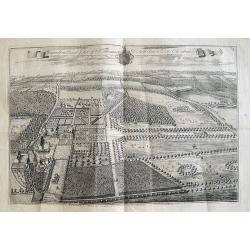
Knowlton Court ye Seat of Sr Thomas D'Aeth Bart & Dame Elizabeth his Wife.
A large copper engraved plan of the manor house. The view is highly detailed, showing buildings, horses, deer, parks, roads, and sailing ships in the background. Below a ...
Date: London, ca 1720
Selling price: ????
Please login to see price!
Sold in 2018
Status Mediolanensis, divisus in Ditiones Mediolanensem, Comum, Cremonam, Paviam, Novaram, Tortonam, Lumellinam et Laudam, una cum Ducatibus Monte Ferrato, Parma, Mutina, Mantua et Mirandula...
A fantastic map of northern Italy, with Aosta in the east, Venice in the west, Trento in the north, and Pisa & Florence in the south. Many famous cities are shown (Mo...
Date: Amsterdam, ca. 1720
Selling price: ????
Please login to see price!
Sold in 2018
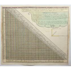
Poliometria Europae Maxime Autem Germaniae ac Finitimorum Locorum.
This unusual thematic chart shows the traveling distances from various European cities in a style that is still used in charts today.JOACHIM OTTENS 1663-1719 - REINER OTT...
Date: Amsterdam, 1720
Selling price: ????
Please login to see price!
Sold in 2020
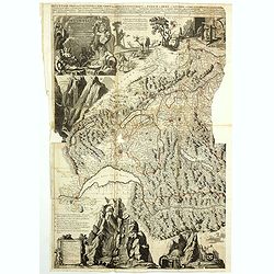
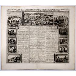
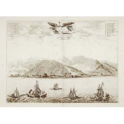
Vue & description de la ville de Siam, des pagodes, des Talapoins ou religieux de ce pais. . .
Page with a profile view on the capital Ayutthaya, the throne of the King, the King who rides an elephant, ships on a lake, the typical plants such as ginseng, the monks ...
Date: Amsterdam, ca. 1720
Selling price: ????
Please login to see price!
Sold in 2020
Accurate Vorstellung der Beruhmten Enge Zwischen der Nord und Ost See dur Sund Genant. . .Copenhagen. . .
A striking and a lovely copper engraved map of Copenhagen and the sound of Sund from Johann Bapt. Homann's "Grosser Atlas.", with original color to map, the vig...
Date: Nuremberg, ca 1720
Selling price: ????
Please login to see price!
Sold in 2019
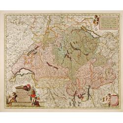
![Carte d'une Partie des Cantons de Berne, de Fribourg du Pais d Veau et du Valais. . . [together with] Zug, Glarus, Basel, Freiburg, Solothurn, Schaffhausen. . .](/uploads/cache/82506-250x250.jpg)
Carte d'une Partie des Cantons de Berne, de Fribourg du Pais d Veau et du Valais. . . [together with] Zug, Glarus, Basel, Freiburg, Solothurn, Schaffhausen. . .
An exceptionally scarce and decorative set of two out of four regional maps of Switzerland by the renowned Swiss polymath Johann Jakob Scheuchzer (1672-1733). The maps ...
Date: Amsterdam, 1720
Selling price: ????
Please login to see price!
Sold in 2020
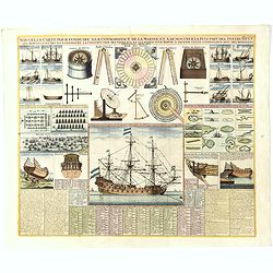
Nouvelle Carte pour conduire a la Connoissance de la Marine . . .
This is a fascinating folio sheet filled with engravings of ships and navigation instruments. At center is a large view of a frigate showing the rigging in great detail. ...
Date: Amsterdam, 1720
Selling price: ????
Please login to see price!
Sold in 2023
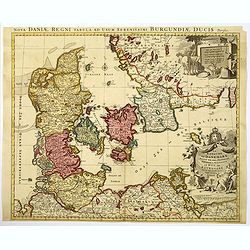
Le Royaume de Danemark divise en ses Provinces. . .
This bold, striking map of Denmark and southern Sweden is engraved to highlight marshes, rivers, cities and towns, shoals and forests. The map is decorated with beautiful...
Date: Amsterdam, ca 1720
Selling price: ????
Please login to see price!
Sold in 2019
Carte généalogique des rois de Navarre de Castille d'Arragon de Portugal et de Grenade, rangée en parallele avec la carte d'Espagne qui distingue les diverses situations de leurs états, leurs armes et alliances.
Interesting sheet with a map of Spain and Portugal and a genealogical tree of the kings of Castile and Navarre, with descriptive French text, from Chatelain's monumental ...
Date: Amsterdam, 1720
Selling price: ????
Please login to see price!
Sold in 2019
Afbeeldinge van't zeer vermaarde Eiland Geks-Kop. . .
The central map of the island of Madhead is contained in an elaborately engraved cartouche surrounded by scenes of ill-fated investors storming the offices of John Law's ...
Date: Amsterdam, 1720
Selling price: ????
Please login to see price!
Sold in 2019
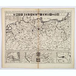
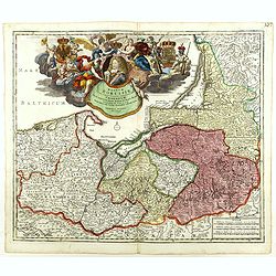
Nouvelle Carte des Differents Etats du Roi de Prusse et de Ceux des Autres Princes de la Maison de Brandebourg.
An interesting map of Germany, focusing on the north. This map covers the area from the French/Dutch borders to Konigsburg (Kaliningrad), including part of modern Poland....
Date: Amsterdam, ca 1720
Selling price: ????
Please login to see price!
Sold in 2021
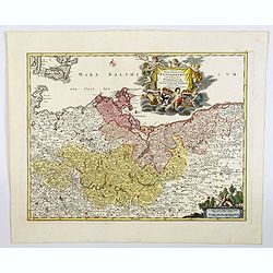
Tabula Marchionatus Brandenburgici et Ducatus Pomerania. . .
A lovely example of the Homann map of Brandenburg and Pomerania, in Germany. The cities of Frankfurt, Brandenburg and Berlin are highlighted in red. This map also include...
Date: Nuremberg, 1720
Selling price: ????
Please login to see price!
Sold in 2019
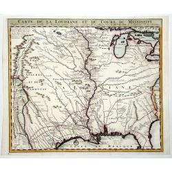
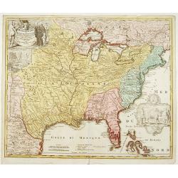
CARTE DE LA LOUISIANE ET DU COURS DU MISSISSIPI.
A nice example of Jean Frederic Bernard's rare variant edition of Guillaume De L'Isle's seminal map, one of the most important and influential maps of the 18th Century, w...
Date: Amsterdam, 1720
Selling price: ????
Please login to see price!
Sold in 2019
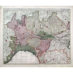
S.R.I. Suevia Circulus et Ducatus, Comprehendes Wirtenbergi Ducatus Augustanum
Decorative and detailed map of Baden-Württemberg and today's Bavarian government district Schwaben. In the lower-left corner is a coat of arms and the upper right corner...
Date: Amsterdam, 1660 - 1720
Selling price: ????
Please login to see price!
Sold in 2023
Carte genealogique de la maison de Courtenay avec les differentes branches quelle a formees accompagnee du Blazon des armes de la plus part des alliances des seigneurs de cette famille.
Genealogical chart, from Chatelain's monumental 7 volume "Atlas Historique". Henri Abraham Chatelain (1684 – 1743) was a Huguenot pastor of Parisian origins. ...
Date: Amsterdam, 1720
Selling price: ????
Please login to see price!
Sold in 2020
Carte généalogique des rois de Navarre de Castille d'Arragon de Portugal et de Grenade, rangée en parallele avec la carte d'Espagne qui distingue les diverses situations de leurs états, leurs armes et alliances.
Interesting sheet with a small map of Spain and Portugal and a genealogical tree of the kings of Castile and Navarre, with descriptive French text, from Chatelain's monum...
Date: Amsterdam, 1720
Selling price: ????
Please login to see price!
Sold in 2020
CARTE DE L'ASIE, Selon les auteurs anciens enriche de Remarques Historiques sur le Changements qui y sont arrivez.
A map of Asia, extending from the Mediterranean, the Red Sea and the Saudi Arabian Peninsula to Japan, the Philippines and Southeast Asia. With explanatory text on either...
Date: Amsterdam, 1720
Selling price: ????
Please login to see price!
Sold in 2019
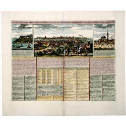
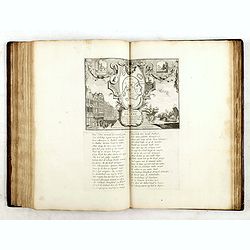
État abrégé de la MAISON du GRAND SEIGNEUR, de ses revenus et le gouvernement civil, militaire et ecclesiastique de cet Empire Grand document gravé.
View of the city of Constantinople, the seraglio of the sultan and of Hagia Sophia. Many insets with information and descriptions.More about "Chatelain Atlas." ...
Date: Amsterdam, 1720
Selling price: ????
Please login to see price!
Sold in 2019
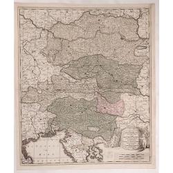
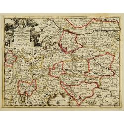
Circuli Austriaci Orientalior Pars in Qua Austria Properia et Abea Dependentes ...
Fine example of Valk's map of Austria, the Gulf of Venice and part of Croatia, Slovenia and Istria. Bounded by the Gulf of Venice and the Golfof Carnero, Stiria and Cher...
Date: Amsterdam, ca. 1720
Selling price: ????
Please login to see price!
Sold in 2023
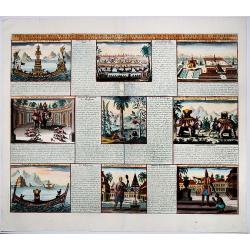
Vue & description de la ville de Lovango dans le Royaume de Congo avec plusieurs....
On top a large view of the fabled city of Lovango, text surrounded by ten vignettes of the people and ceremonies of the Kingdom of Congo.Zacharie Chatelain (d.1723) was t...
Date: Amsterdam, 1720
Selling price: ????
Please login to see price!
Sold in 2019
Vue & description de la ville de Siam, des Pagodes, des Talapoins oureligeux ce ce pais, des balons du roi & de ses elephans, de la maniere de dompter ces ..
Page with a profile view on the capital Ayutthaya, the throne of the King, the King who rides an elephant, ships on a lake, the typical plants such as ginseng, the monks ...
Date: Amsterdam, ca. 1720
Selling price: ????
Please login to see price!
Sold in 2019
Het Groote Tafereel der Dwaasheid
AN EARLY ISSUE of this biting and vulgar satire on the Mississippi and South Sea Bubbles and an extraordinary visual record with 78 plates of the first banking crash, sho...
Date: Amsterdam, 1720
Selling price: ????
Please login to see price!
Sold in 2017
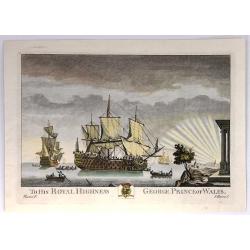
To His Royal highness, George, Prince of Wales
This print was one of twelve, then twenty, drawn and engraved by Thomas Baston, and published by Carrington Bowles in “Twenty-two Prints of Several of the Capital Ships...
Date: London, c1720
Selling price: ????
Please login to see price!
Sold in 2020
Le Golfe de Panama &cc.Cartagene,..
An impressive large sheet chart of Panama and part of the Colombia coast up to Santa Nevada de Santa Marta. In top left corner, detailed inset map (190x460mm) of Sambalas...
Date: Amsterdam 1720
Selling price: ????
Please login to see price!
Sold
De stadt Algier.
Rare panoramic view of Algiers in Algeria.Printed by Covens and Mortier, who used the plates originally engraved for Montanus. Uncommon issue.
Date: Amsterdam 1720
Selling price: ????
Please login to see price!
Sold
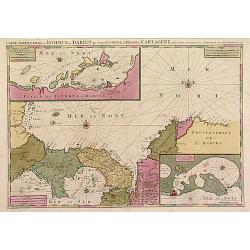
Groningae et Omlandiae Dominium vulgo De Provincie van Stadt en Lande, cum subjacent. Territ. Praefect. et Tractibus. [Lud Tjarda â Starckenburg. Nicol:Visscher. . .
Detailed map of the northern Dutch region of Groningen with figurative cartouche and coats of arms. The town of Groningen in the center, Emden just on the right. Engraved...
Date: Amsterdam, 1685/ 1720
Selling price: ????
Please login to see price!
Sold in 2017
Planisphaerium Caeleste Secundum Restitutionem Hevelianam et Hallejanam. . .
A very decorative double hemisphere celestial chart, centered on the North and South Poles.With smaller circular diagrams illustrating the theories of Tycho, Ptolemy and ...
Date: Augsburg, 1720
Selling price: ????
Please login to see price!
Sold
Amplissimae Regionis Mississipi,.. Provinciae Ludovicianae
Attractive map of present-day U.S. from Nouveau Mexico to the Atlantic, centring on the French province of Louisiana, with the English colonies and Spanish Florida indica...
Date: Nuremberg 1720
Selling price: ????
Please login to see price!
Sold
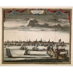
Amsterdam. Capitale de la Hollande.
A panoramic view of the town of Amsterdam seen from 't IJ.Rare.
Date: Leiden 1720
Selling price: ????
Please login to see price!
Sold
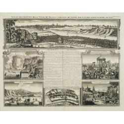
Vue et description de la Ville de Meaco Capitale du Japon..
"Top part of the print shows the town of Meaco (Kyoto) at that time the capital of Japan, with a coach and horses in the foreground. Other parts show among other thi...
Date: Amsterdam, 1720
Selling price: ????
Please login to see price!
Sold in 2010
Exactissima Helvetiae, Rhaetiae, Valesia..
Engraved by A.Hogeboom. A re-issue of the map by Nicolaes Visscher. On verso a alphabetical table for locating cities in Switzerland.
Date: Amsterdam 1720
Selling price: ????
Please login to see price!
Sold in 2011
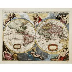
Nova delineatio Orbis Terrarum..
Very decorative with double hemispheres surrounded by six figures representing earth, fire, water, day and night. Shows California as an island. Based on Colom's rare 165...
Date: Leiden 1720
Selling price: ????
Please login to see price!
Sold
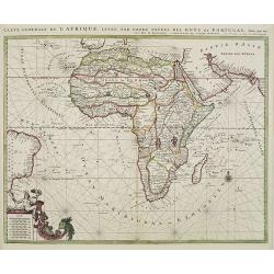
Carte generale de L'Afrique, levée par ordre expres des roys de Portugal..
An impressive chart of the continent of Africa. Decorative scale cartouche to the lower left and the eastern tip of Brazil.
Date: Amsterdam, 1720
Selling price: ????
Please login to see price!
Sold in 2012
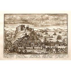
Accurate Vorstellung der .. Constantinopel..
The upper part shows Constantinople with adjoining regions. The bottom part shows a prospect of the town.
Date: Nuremberg 1720
Selling price: ????
Please login to see price!
Sold
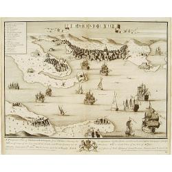
Edimbourg Ville Capitale du Royaume d'Ecosse.
"A very RARE panoramic view of the city of Edinburgh, including a numbered legend in the lower part.Published by the brothers Chéreau, active in Paris at ...
Date: Paris c.1720
Selling price: ????
Please login to see price!
Sold
Der Neuen Welt.. / Der Alte Welt..
Two maps on one sheet, showing eastern and western hemisphere. In each corner portrait of important explorers: Columbus, Drake, Vespucci, Magalhaes, Schouten, Dampier, Ta...
Date: Augsburg 1720
Selling price: ????
Please login to see price!
Sold
The Travels of st. Paul ..
Around 1655 Moxon (1627-1700 ) visited Amsterdam, probably to learn from the Dutch if there was a northern passage to the Indies. In Amsterdam he met father Claes and son...
Date: London 1720
Selling price: ????
Please login to see price!
Sold
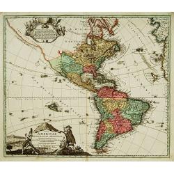
Totius Americae Septentrionalis et Meridionalis.
Richly ornamented map of North and South America. Title cartouche bottom left is copied from De Fer's map of 1699 and cartouche containing text (top left) is based on De ...
Date: Nuremberg 1720
Selling price: ????
Please login to see price!
Sold
Cercle d'Autriche..
Decorative map of Austria with a nice title cartouche.
Date: Leiden, c.1720
Selling price: ????
Please login to see price!
Sold
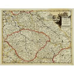
La Bohême, suivant les nouvelles observations?
With decorative title cartouche upper right corner.
Date: Leiden c.1720
Selling price: ????
Please login to see price!
Sold
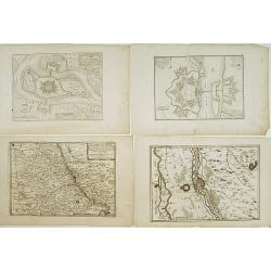
Lot : 10 maps and city views centered on the river Rhine.
Lot : 10 maps and city views centered on the river Rhine. Maps and prints by Braun and Hogenberg/ de Fer.
Date: c.1720
Selling price: ????
Please login to see price!
Sold
Archiducatus Austriae superioris in suas Quadrantes..
Map of the northern area of Austria. Large decorative uncolored cartouche upper left.Several cities underlined with ink, manuscript addition.
Date: Nuremberg 1720
Selling price: ????
Please login to see price!
Sold
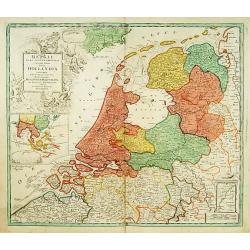
Belgii pars Septentrionalis vulgo Hollandia..
A large, decorative -colored- title cartouche at top left. In an inset -122x140mm- under the title cartouche a small map of Southeast Asia with a panoramic view of the po...
Date: Nuremberg 1720
Selling price: ????
Please login to see price!
Sold
Den AARDBODEM na de Zundvloed door NOACHs dri Soonen en hare nakomelingen bevolkt.
Decorative historical world map indicating the regions where the three sons of Noach have lived. To the right is a family tree. At the bottom are several coins.
Date: The Netherlands 1720
Selling price: ????
Please login to see price!
Sold
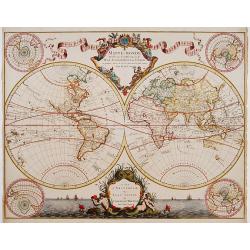
Mappe-Monde dressé sur les observations de.. par M.de L'Isle.
Guillaume de L'Isle became one of the foremost geographers of his age. He was tutored by Jean-Dominique Cassini and at the age of 25 produced a globe, maps of the four co...
Date: Amsterdam 1720
Selling price: ????
Please login to see price!
Sold
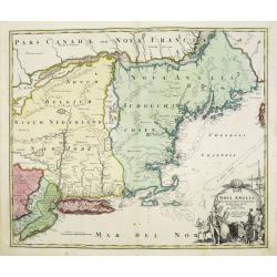
Nova Anglia Septentrionali Americae implantata . . .
German interest in North America was high during the first half of the eighteenth century when Johann Baptiste Homann was the leading German cartographer. During this per...
Date: Nurnberg, 1720
Selling price: ????
Please login to see price!
Sold in 2022
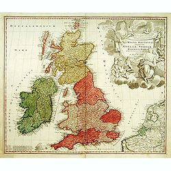
Magna Britannia?
A decorative of Britain and Ireland with great details. Includes part of France, Belgium and Holland. The large title cartouche is very decorative.
Date: Nuremberg, 1720
Selling price: ????
Please login to see price!
Sold
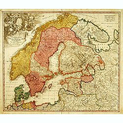
Scandinavia complectens Sueciae, Daniae & Norvegia.
Johann Baptist Homann's well-engraved map has a large decorative cartouche. Detailed map of Scandinavia. Johann Baptist Homann (1663-1724) was a German engraver and publi...
Date: Nuremberg, 1720
Selling price: ????
Please login to see price!
Sold
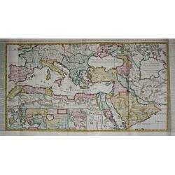
Carte de l\' Empire Othoman consideréedans les Etats de cette Puissance, et Etats qui l\' avoisinent ou qui luy sont tributaires. / Carte pour servir a l\' Histoire Universelle / Carte de la Grèce.
Henri Abraham Chatelain was a Amsterdam-based geographer and publisher. His main product is the 'Atlas Historique et Méthodique', in seven volumes, published between 171...
Date: Amsterdam, 1710 / 1720
Selling price: ????
Please login to see price!
Sold in 2009
Mappe-Monde dressé sur les observations de..
Guillaume de L'Isle became one of the foremost geographers of his age. He was tutored by Jean-Dominique Cassini and at the age of 25 produced a globe, maps of the four co...
Date: Amsterdam 1720
Selling price: ????
Please login to see price!
Sold
Portsmouth.
A very fine and quite large view of Portsmouth from Joannes Kip's Britannia Illustrata or Views of Several of the Queens Palaces also of the Principal Seats of the Nobili...
Date: London 1708-1720
Selling price: ????
Please login to see price!
Sold
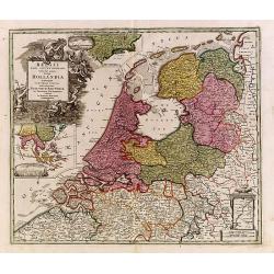
Belgii pars Septentrionalis vulgo Hollandia..
A large, decorative -colored- title cartouche at top left. In an inset -122x140mm- under the title cartouche a small map of Southeast Asia with a panoramic view of the po...
Date: Nuremberg 1720
Selling price: ????
Please login to see price!
Sold
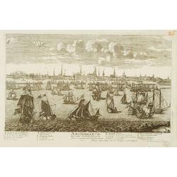
Amsterdam Ville du Comte de Hollande.
A very RARE panoramic view of the city of Amsterdam, including a legend in the lower both corners.The plate is numbered in red pencil in upper right corner.Engraved by Je...
Date: Paris 1690-1720
Selling price: ????
Please login to see price!
Sold
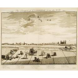
Prospect of Cambridge from the west.
A very fine and quite large view of Cambridge seen from the west, from: Britannia Illustrata or Views of Several of the Queens Palaces also of the Principal Seats of the ...
Date: London 1708-1720
Selling price: ????
Please login to see price!
Sold
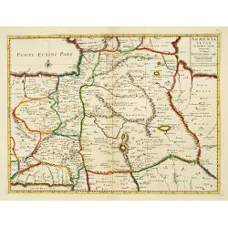
Armenia Vetus In Quatuor Partes..
Uncommon map of ancient Armenia.
Date: Amsterdam 1720
Selling price: ????
Please login to see price!
Sold
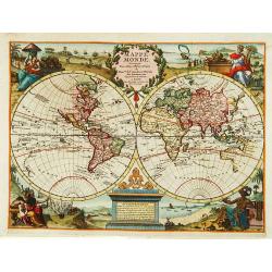
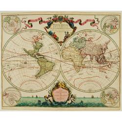
Mappe Monde.
Decorative world map in two hemispheres. Vignettes symbolising the four continents occupy the corners: between the hemispheres there are two elaborate cartouches.
Date: Leiden 1720
Selling price: ????
Please login to see price!
Sold
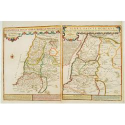
Descriptio Acurata Terrae Promissae.. Terre Sainte Moderne.
To the left a very attractive map of Palestine on both sides of the Jordan, after Philippe de La Rue. To the right hand side a map of Terre Sainte Moderne , under Turkish...
Date: Paris 1720
Selling price: ????
Please login to see price!
Sold