Browse Listings
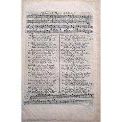
William and Margaret - A Ballad.
Very unusual musical sheet with text, by David Mallet. Famous ballad from around 1720. Only few examples are known! We could only locate holdings in the British Museum.
Date: unknown, ca. 1720
Selling price: ????
Please login to see price!
Sold in 2014
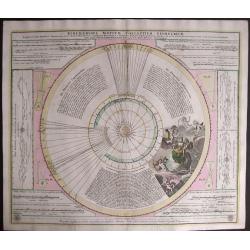
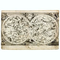
Ephemerides Motuum Coelestium Geometricae.
A fine and decorative celestial chart, describing the orbit of the planets in the Copernican Solar system. The central diagram represents the solar system, with the Sun a...
Date: Nuremberg, 1720
Selling price: ????
Please login to see price!
Sold in 2014
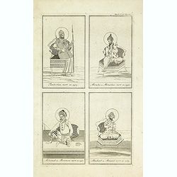
Tamberlan, mort en 1405. - Miracha ou Miraschae, mort en 1451. - Mohamed ou Miramont mort en 1451. - Abuchaid ou Abuzaid mort en 1469.
Striking and highly detailed copper engraved plate including 4 Indian princes or kings. From Chatelain's Atlas Historique, 1732-1739. In upper right margin: 'Tom. V. Nro ...
Date: Amsterdam, 1720
Selling price: ????
Please login to see price!
Sold in 2014

Sek ou Seich Omar, mort en 1493. Babar ou Baber ou Babour, mort en 1530. Amayum ou Houmayon, mort en 1552. Akebar ou Xa Aguebar, mort en 1605.
Striking and highly detailed copper engraved plate including 4 Indian princes or kings. From Chatelain's Atlas Historique, 1732-1739. In upper right margin: 'Tom. V. No 3...
Date: Amsterdam, 1720
Selling price: ????
Please login to see price!
Sold in 2014
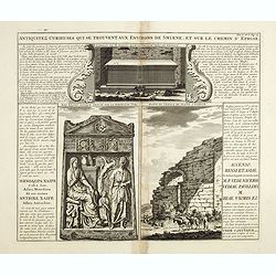
Antiquités curieuses de qui se trouvent aux environs de Smyrne, et sur le chemin d´Ephese.
Striking and highly detailed copper engraved plate showing monuments in Ephesus which was an ancient Greek city on the coast of Ionia, three kilometers southwest of prese...
Date: Amsterdam, 1720
Selling price: ????
Please login to see price!
Sold in 2014
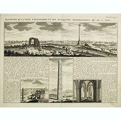
Description de la Ville d'Alexandrie et des Antiquites Remarquables qu'on y voit.
Panoramic view of the ancient Egyptian port city of Alexandria accompanied by insets of "Palais de Cleopatre" (the ruins of Cleopatra's palace), Obelisque d'Ale...
Date: Amsterdam, 1720
Selling price: ????
Please login to see price!
Sold in 2016
![[. . .] rte Ancienne et Moderne des Differents Etats et Pais situez au Long du Danube, pour servir a L'Intelligence De L'His [. . .]](/uploads/cache/34428-250x250.jpg)
[. . .] rte Ancienne et Moderne des Differents Etats et Pais situez au Long du Danube, pour servir a L'Intelligence De L'His [. . .]
A striking and highly detailed copper engraved plate with a map of region north of the Adriatic Sea and centered on the Danube River, from Croatia to the Black Sea. Inclu...
Date: Amsterdam, 1720
Selling price: ????
Please login to see price!
Sold in 2014
![[. . .] ur servir d'introduction à l'histoire Romaine et à celle de l'Empire, ou l'on fait observer la genealogie de cr [. . .]](/uploads/cache/34429-250x250.jpg)
[. . .] ur servir d'introduction à l'histoire Romaine et à celle de l'Empire, ou l'on fait observer la genealogie de cr [. . .]
A striking and highly detailed copper engraved plate with a map of the ancient Roman Empire, including Europe as far east as the Black Sea. Including descriptive text pan...
Date: Amsterdam, 1720
Selling price: ????
Please login to see price!
Sold in 2014
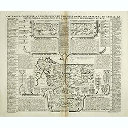
Carte pour conduire a l'inteligence de l'Histoire Sacree qui renferme en abree la genealogie, la geographie, et la chronologie de l'Histoire Sainte.
Four maps of the Holy Land on the same sheet. The main map in the middle of the sheet: "Carte de l’introduction du peuple d’Israel dans le Pais de Canaan..."...
Date: Amsterdam, 1720
Selling price: ????
Please login to see price!
Sold in 2014
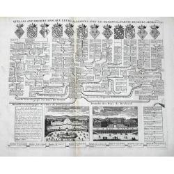
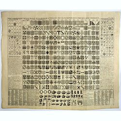
Carte des pavillons accompagnée d'observations pour en faire comprendre le blazon et les différentes devises aussy bien que d'une table alphabétique pour les trouver facilement.?
Map of 88 marine flags.
Date: Amsterdam, 1720
Selling price: ????
Please login to see price!
Sold in 2014
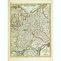
Nouvelle Carte De Moscovie Ou Sont Representes Les Differents Etats De Se Maiesete Czarienne En Europe Et En Asie...
Very detailed, large map of Russia, which, importantly, extends from the Black Sea and from the Balkans to China and the Mer De Tartarie, and hence includes a large part ...
Date: Amsterdam, 1720
Selling price: ????
Please login to see price!
Sold in 2015
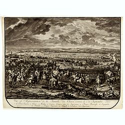
Vue et représentation de la Bataille de Chiari donnée le 1 septebre 1703. . .
Extremely fine and detailed engraving by Huchtenburg depicting the siege of Chiari (Italy) by Price Eugene on September 1st 1703.From Jean Dumont's, "Batailles gagn�...
Date: The Hague, Pierre Husson, 1720
Selling price: ????
Please login to see price!
Sold in 2014
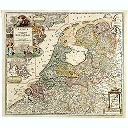
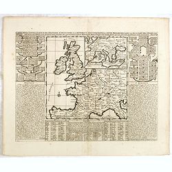
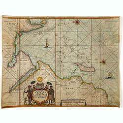
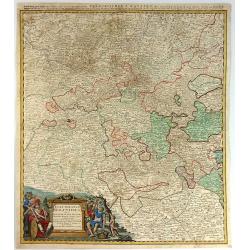
Belgii pars Septentrionalis vulgo Hollandia. . .
A large, decorative colored title cartouche at top left. In an inset -122x140mm- under the title cartouche a small map of Southeast Asia with a panoramic view of the port...
Date: Nuremberg, 1720
Selling price: ????
Please login to see price!
Sold in 2014
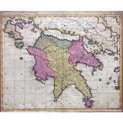
Regnum Moreae accuratissime divisum in Provincias Saccaniam, Tzaconiam, Caliscopium et Ducatum Clarensae, una cum Insulis Cephalonia, Zacyntho, Cythera, Aegina et Sidra
Uncommon map of Greece, by Gerardus Valk and Leonardus Valk in old colors.
Date: Amsterdam, circa 1720
Selling price: ????
Please login to see price!
Sold in 2017
Carte historique chronologique et géographique de l'empire romain où l'on fait observer son étendue et diverses remarques pour l'intelligence de l'histoire.
Interesting sheet with a map of the Roman Empire, with descriptive French text, from Chatelain's monumental 7-volume "Atlas Historique". In upper right margin: ...
Date: Amsterdam, 1720
Selling price: ????
Please login to see price!
Sold in 2017
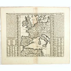
Carte de la Germanie et les différents états où ses peuples ont porté leurs conquètes.
Interesting sheet with a map of Europe, with descriptive French text, from Chatelain's monumental 7-volume "Atlas Historique". In upper right margin: 'Tome 2, N...
Date: Amsterdam, 1720
Selling price: ????
Please login to see price!
Sold in 2014
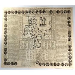
Nouvelle carte pour introduire à la géographie et à la généalogie des rois d'Angleterre et d'Ecosse avec diverses remarques pour le secours de la chronologie et de l'Histoire.
Interesting sheet with a map of the family tree for the Royal Families of Great Britain, Scotland, and France, with descriptive French text, from Chatelain's monumental 7...
Date: Amsterdam, 1720
Selling price: ????
Please login to see price!
Sold in 2015
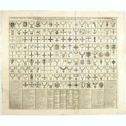
Nouvelle carte des ordres militaires ou de la chevalerie institués par divers princes pour récompenser le mérite ou la vertu par reconnaissance de quelque signalée victoire.
Interesting sheet with an illustration of all the medals awarded to the Knights, with descriptive French text, from Chatelain's monumental 7-volume Atlas "Historique...
Date: Amsterdam, 1720
Selling price: ????
Please login to see price!
Sold in 2014
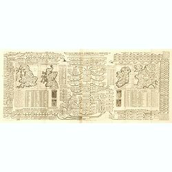
Carte généalogique pour conduire à l'histoire des rois du nord de la carte de leurs états, leurs armes et des remarques pour conduire à l'intelligence de l'histoire du nord.
Interesting sheet with a genealogical table of the Kingdoms of the Scandinavian countries with two small maps: Scandinavia and Southern Sweden, with descriptive French te...
Date: Amsterdam, 1720
Selling price: ????
Please login to see price!
Sold in 2018
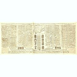
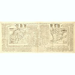
Carte généalogique des rois de Navarre de Castille d'Arragon de Portugal et de Grenade, rangée en parallele avec la carte d'Espagne qui distingue les diverses situations de leurs états, leurs armes et alliances.
Interesting sheet with a map of Spain and Portugal and a genealogical tree of the kings of Castile and Navarre, with descriptive French text, from Chatelain's monumental ...
Date: Amsterdam, 1720
Selling price: ????
Please login to see price!
Sold in 2014
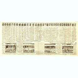
Carte généalogique des branches naturelles du coté gauche de la maison de Bourbon accompagnée des armes et alliances
Interesting sheet with an impressive engraving ornamented with numerous vignettes representing French castles of Meudon, Versailles, St. Germain en Laye and Fontaine Blea...
Date: Amsterdam, 1720
Selling price: ????
Please login to see price!
Sold in 2014
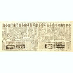
Nouvelle carte généalogique des branches du coté gauche de la maison Valois.
Interesting sheet with a map of the family tree of the house of Valois. In lower part views of les Invallides, Trianon, Versailles, St.Cloud and descriptive French text, ...
Date: Amsterdam, 1720
Selling price: ????
Please login to see price!
Sold in 2022
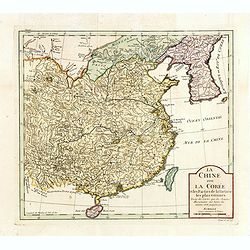
La Chine avec La Corée et les parties de la Tartarie les plus voisines..
Fine map of China, Korea and Taiwan (named as Tayouan ou Formose I.). Prepared after Jesuit sources from 1708-1717.The map is of interest for the use of Kao-Liqoue ou Roy...
Date: Paris, 1720
Selling price: ????
Please login to see price!
Sold in 2023
L'Empire de Russie Comprenant la Moscovie, le Royaume la Moscovie. . . 1769.
Uncommon map of Russia. Engraved by Jean Crepy (the father) who was active as an engraver and publisher at the end of the 17th and beginning of the 18th century. He was a...
Date: Paris, 1690-1720
Selling price: ????
Please login to see price!
Sold in 2014
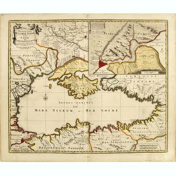
Nouvelle Carte de la Mer Noire et du Canal de Constantinope.
Decorative and uncommon map of the Black Sea region. In the upper left-hand corner is an inset map (200x280) of the Bosporus including Istanbul.
Date: Amsterdam, 1680, 1720
Selling price: ????
Please login to see price!
Sold in 2014
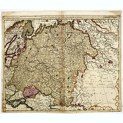
Russia Alba, sive Moscovia, regio valde extensa, divisaque in Regna, Ducatus, Principatus, et Provincias, cum adjacentibus Regnis . . .
Scarce map of European Russia, including Ukraine. Extending to the east, showing some portion of the Tartar and Mongol regions.
Date: Amsterdam, 1720
Selling price: ????
Please login to see price!
Sold in 2014
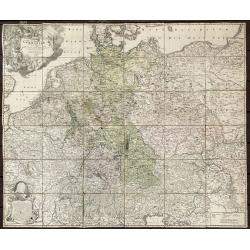
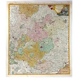
Tabula Novissima Totius Germaniae praecipuè ex Designatione Viri celeberrimi Dni Johannis Caspari Eisenschmidii 1711.
Folding wall map of Greater Germany, with cartouche of imperial German double-headed eagle, putti and instruments, and female figure (royal or allegorical).Extremely Rare...
Date: Nurnberg, 1720
Selling price: ????
Please login to see price!
Sold in 2020
Carte pour l'itelligence de l'histoire dAngleterre où on remarque les conquètes de cette monarchie dans la plupart des états de l'europe, les droits sur lesquels sont fondées ses prétentions sur la monarchie française ou sur divers états...
Interesting sheet with historical and genealogical copper engraving, extracted from the historical atlas: introduction to the history, chronology, ancient and modern geog...
Date: Amsterdam, 1720
Selling price: ????
Please login to see price!
Sold in 2021

Carte des différents colleges de l'Empire, l'ordre de l'élection du sacre et du couronnement de l'Empereur.
Interesting sheet with an illustration of the various colleges of the German Empire, the order of the election and coronation of the coronation of the Emperor, with descr...
Date: Amsterdam, 1720
Selling price: ????
Please login to see price!
Sold in 2020
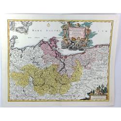
Ducatus Luneburgici et Comitatus Dannebergensis.
Map of the Principality of Lüneburg and the County of Dannenberg. Top right detailed title cartouche with coat of arms, knights and rulers representation. In addition, P...
Date: Nuremberg, 1720
Selling price: ????
Please login to see price!
Sold in 2018
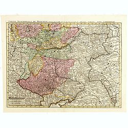
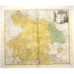
Partie Meridionale de Moscovie. . .
Centered on Moscow including Azow and part of present-day Ukraine in the bottom part of the map. The map is based on Delisle's important map of the region with revisions ...
Date: Amsterdam, 1720
Selling price: ????
Please login to see price!
Sold in 2018
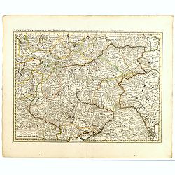
Partie Meridionale de Moscovie. . .
Centered on Moscow including Azow and part of present-day Ukraine in the bottom part of the map. The map is based on Delisle's important map of the region with revisions ...
Date: Amsterdam, 1720
Selling price: ????
Please login to see price!
Sold in 2018
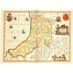
Ceretica Sive Cardiganensis Comnitatus;Anglis Cardigan Shire.
Splendid decorative map with two figurative, allegoric cartouches, two putti, three heraldic family coats of arms and three ships. A fine map of Cardigan Shire.
Date: Amsterdam, 1720
Selling price: ????
Please login to see price!
Sold in 2015
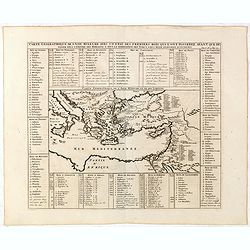
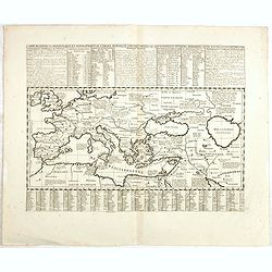
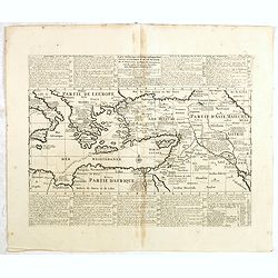
Carte geographique de l'Asie mineure avec un etat des premiers rois. . .
Map of the Mediterranean. This impressive engraving is a wonderful example of Chatelain’s elegant plates from his "Atlas Historique, Ou Nouvelle Introduction A L�...
Date: Amsterdam, ca. 1720
Selling price: ????
Please login to see price!
Sold in 2022
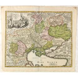
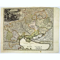
Ukrania quae et Terra Cosaccorum. . .
Homann's map is based upon Beauplan's general map of Ukraine but depicts the political changes of the preceding years. The cartouche portrays Hetman Mazepa with his follo...
Date: Nuremberg, 1720
Selling price: ????
Please login to see price!
Sold in 2015
Carte pour l'intelligence de l'Histoire d'Angleterre où on remarque les conquêtes de cette monarchie dans la plupart des états de l'Europe, les droits sur lesquels sont fondées ses prétentions sur la monarchie sur divers états qui lui ont été...
Interesting sheet with an old map, historical and genealogical copper engraving, extracted from the historical atlas: introduction to the history, chronology, ancient and...
Date: Amsterdam, 1720
Selling price: ????
Please login to see price!
Sold in 2015
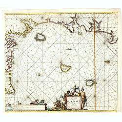
A chart of the Western Part of the East-Indies with all the Adjacent Islands from Cape Bona Esperanca to the Island od Zelone.
This scarce sea of the Indian Ocean from the Cape of Good Hope to the west coast of India (Malabar). First issued by John Seller, the present example published by Mount ...
Date: London, Mount & Page, ca. 1720
Selling price: ????
Please login to see price!
Sold in 2015
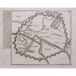
Königsberg (Kaliningrad).
Early layout of Kaliningrad just about when it became the capital of Prussia in 1724! With interesting text in German to the side.
Date: Augsburg, ca. 1720
Selling price: ????
Please login to see price!
Sold in 2015
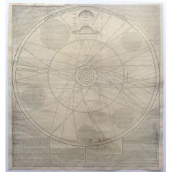
A Scheme of the Solar System with the Orbits of the Planets and Comets belonging thereto, Described from Dr Halley's accurate Table of Comets Philosoph. Transact no. 297. Founded on Sr. Isaac Newton's wonderful discoveries.
Important, separately issued, celestial chart of the solar system, first prepared by William Whiston in 1712 and published by John Senex in London. The map was most likel...
Date: London, c1720
Selling price: ????
Please login to see price!
Sold in 2015
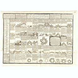
Le Jeu des fortifications . . . (The Game of Fortifications)
A board game comprising an uncut sheet of 52 playing-cards in which are represented and explained the details of military fortification. Prepared by Gilles de la Boissiè...
Date: Paris, 1691 - 1720
Selling price: ????
Please login to see price!
Sold in 2016
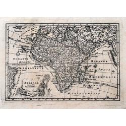
Africae emendata Descriptio.
Very interesting map of Africa, including Arabia, Persia, the Maledives, and a small part of Brazil. With many details and place names. Also a "Terra Incognita"...
Date: Nuremberg, ca. 1720
Selling price: ????
Please login to see price!
Sold in 2015
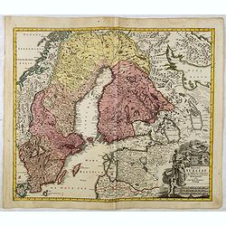
Regni Sueciae in omnes suas Subjacentes Provincias accurate divisi Tabula Generalis. . .
Johann Baptist Homann's well-engraved map of Scandinavia, the Baltic Sea, Lithuania, Latvia, Estonia, Curlandia, etc. with a large decorative title cartouche.Johann Bapti...
Date: Nuremberg, ca. 1720
Selling price: ????
Please login to see price!
Sold in 2016
Ukrania quae et Terra Cosaccorum..
Fine map including Ukraine, Russia, Muscovy and the Cossack Regions in the North, to the Black Sea, Circcasian Tartary, Constantinople and Transylvania in the South.Homan...
Date: Nuremberg, 1720
Selling price: ????
Please login to see price!
Sold in 2015
Carte Genealogique de la Maison de Wassenaar ...
A magnificent large copper engraved chart, featuring the genealogy of the House of Wassenaar in Holland. There are four fine topographical engravings, and 41 coats of arm...
Date: Paris, 1720
Selling price: ????
Please login to see price!
Sold in 2016
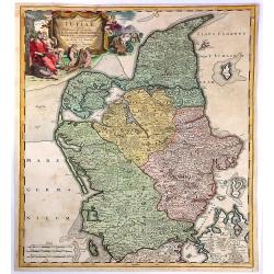
Tabula Generalis Iutiae.
A spectacular and historically important map of the northern part of Denmark, that is called Jutland.It features a wonderful, oversized, decorative drape title cartouche ...
Date: Nuremberg, 1720
Selling price: ????
Please login to see price!
Sold in 2018
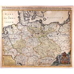
Regni Bourussiae et Electoratus Brandenburgici
A map of the Kingdom of Prussia and Brandenburg in Germany between the Dutch border, Memel and Kaliningrad and Bodensee/Lake Constance. Major postal routes (‘Stationes ...
Date: Amsterdam, c1720
Selling price: ????
Please login to see price!
Sold in 2016
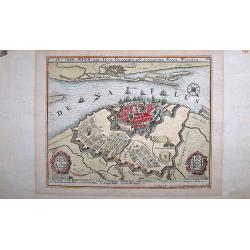
Die Stadt Riga Mitt Ihren Vorstaetten projectirten Neuen Werchen.
A fine, decoratively engraved map of the city of Riga, the capitol city of Latvia, by Gabriel Bodenehr the Elder (c.1664-1758). He was a Swiss artist who worked in Augsbu...
Date: Augsburg, ca 1720
Selling price: ????
Please login to see price!
Sold in 2021
Carte Pour l'Introduction a l'Histoire d'Angleterre, ou l'on Voit son Premier Gouvernement, et l'Etat Abrege de cette Monarchie sous les Empereurs Romains, et sous les Rois Saxons...
A large inset map of Roman Britain including the English Channel and the western coast of France. It also provides a wealth of information on the principal Roman towns ac...
Date: Amsterdam, 1720
Selling price: ????
Please login to see price!
Sold in 2018
Electoratus Moguntinus ut et Palatin. Infer. Hassiae...
A map of the area around Mainz, covering the southern parts of Hessen with Frankfurt in the centre, and reaching along the Rhein to Koblenz in the north and Speyer in the...
Date: Nuremberg, 1720
Selling price: ????
Please login to see price!
Sold in 2016
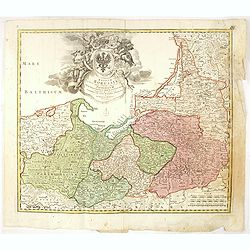
Regnum Borussiae gloriosis auspiciis serenissimi et potentissimi princip. Friderici III primi Borussiae regis march. et elect. Brandenburg inauguratum die 18 Jan...1701.
Map covering the region along the Baltic Sea from Prussia to northern Poland.Beautiful ornamental title cartouche in upper center. Centered on Danzig, Konigsberg, Heilspe...
Date: Nuremberg, 1720
Selling price: ????
Please login to see price!
Sold in 2016
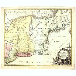
Nova Anglia Septentrionali Americae implantata ..
German interest in North America was high during the first half of the eighteenth century when Johan Baptiste Homann was the leading German cartographer. During this peri...
Date: Nuremberg, 1720
Selling price: ????
Please login to see price!
Sold in 2016
Pas caarte van de Bocht van Gabon Tusschen C. Formose en C. de Lopo Gansalves. . .
This map depicts the west coast of Gabon from Cape Formosa to Cape de Lopo, with the islands of St. Thomas and Principi.
Date: Amsterdam, 1720
Selling price: ????
Please login to see price!
Sold in 2016
Circuli Franconiae Pars Orientalis et Potior...
A fine map of Franconia (Franken, part of Bavaria), Germany, that is centred on Nuremberg, extending north as far as Gotha, south to Neuberg, west from Wertzberg and east...
Date: Nuremberg, 1720
Selling price: ????
Please login to see price!
Sold in 2016
Versailles / St. Cloud
An interesting double page, showing the genealogy of Ducs de Nevers, Ducs de Bourgogne, Ducs de Brabant etc. It features 12 lovely coat of arms, and views of Versailles a...
Date: Amsterdam, 1720
Selling price: ????
Please login to see price!
Sold in 2016

Aftekening der Schilderye, op't Stadhuis te Dordrecht geplaatst, ter gedagtenisse van de Overwinning by Chattam, in't Jaar 1667, onder't beleid van Kornelis de Wit, Ruwaard van Putten
The scene of the Battle of Chatham. Glorification of Grand Pensionary Kornelis de Witt, the commander in armour, holding a baton. He is, being crowned with a laurel by a ...
Date: Amsterdam, circa 1720
Selling price: ????
Please login to see price!
Sold in 2019
Tabula Marchionatus Brandenburgici et Ducatus Pomeraniae...
A striking map of Brandenburg and Pomerania Germany by J.B. Homann ca. 1720. It also includes Frankfurt and Berlin as well as parts of Denmark and Poland. Issued in Homan...
Date: Nuremburg, 1720
Selling price: ????
Please login to see price!
Sold in 2017
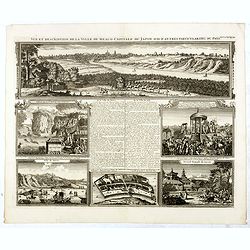
Vue et description de la Ville de Meaco Capitale du Japon. . .
Top part of the print shows the town of Meaco (Kyoto) at that time the capital of Japan, with a coach and horses in the foreground. Other parts show among other things th...
Date: Amsterdam, 1720
Selling price: ????
Please login to see price!
Sold in 2016
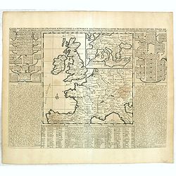
![[London to Portsmouth by John Owen & Emanuel Bowen.]](/uploads/cache/97413-250x250.jpg)
[London to Portsmouth by John Owen & Emanuel Bowen.]
Two conjoined strip road maps page numbers 72 & 73 from “Britannia Depicta or Ogilby Improved.” A pocket road atlas by John Owen and Emanuel Bowen. Together these...
Date: London, 1720
Selling price: ????
Please login to see price!
Sold in 2016
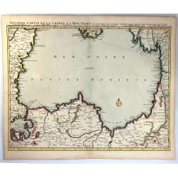
Seconde Partie de la Crimee la Mer Noire. . .
A fine map featuring the lower part of the Black Sea. Part of a set of two maps from the observations of Guillaume Delisle, with wonderful detail of the surrounding regio...
Date: Amsterdam, 1720
Selling price: ????
Please login to see price!
Sold in 2016
Carte historique et géographique pour servir à l'Histoire Sainte et à la Vocation de Saint Paul, avec quelques remarques curieuses pour servir à l'Histoire des Antiquités judaïques.
Interesting sheet with a map of the travels of Saint Paul, including eastern part of Europe, Asian continent and part of north Africa, with descriptive French text, from ...
Date: Amsterdam, 1720
Selling price: ????
Please login to see price!
Sold in 2016
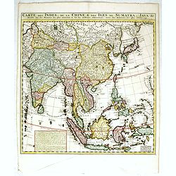
Carte des Indes, de la Chine & des Isles de Sumatra, Java &c..
This fine and quite detailed general map extends from northern Japan to Timor and from India to New Guinea.Here, the Terre de Yeco in northern Japan is still joined to th...
Date: Amsterdam, 1720
Selling price: ????
Please login to see price!
Sold in 2017
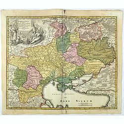
Ukrania seu Cosacorum Regio Walachia item Moldavia et Tartary minor.
A detailed map of the countries and southern Russian provinces that border the Black Sea, including present day Ukraine, Moldova, Bulgaria, Moscovie and Turkey (in Europe...
Date: Nuremberg, ca. 1720
Selling price: ????
Please login to see price!
Sold in 2016
Hemel globe. / Coeli enarrant Gloriam del.
Charming double hemisphere celestial map on a polar projection. The map depicts the ecliptic pole to ecliptic, joined through winter solstice.It is based on the Hondius m...
Date: Amsterdam, 1720
Selling price: ????
Please login to see price!
Sold in 2024
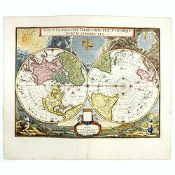
Novus Planiglobii Terrestris per Utrumque polum conspectus.
Until recently it was believed that the Blaeu establishment produced only two world maps for its atlases -the rectangular map of 1606 and the double hemisphere of 1662. H...
Date: Amsterdam, 1720
Selling price: ????
Please login to see price!
Sold
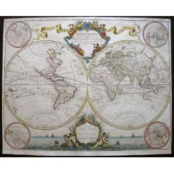
Mappe-Monde dressé sur les observations de.. par M.de L'Isle
Guillaume de L'Isle was one of the first, in his world map, to correct the extended length of the Mediterranean, and to give back to California its true peninsular format...
Date: Amsterdam, 1720
Selling price: ????
Please login to see price!
Sold in 2016
Ukrania quae et Terra Cosaccorum. . .
Homann's map is based upon Beauplan's general map of Ukraine but depicts the political changes of the preceding years. The cartouche portrays Hetman Mazepa with his follo...
Date: Nuremberg, 1720
Selling price: ????
Please login to see price!
Sold in 2025
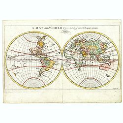
A map of the World, corrected by the latest Observations.
Map in two hemispheres, most likely after Herman Moll's "A map of the world on wch. is delineated the voyages of Robinson Curso." London, 1719 and probably prin...
Date: London, ca. 1720
Selling price: ????
Please login to see price!
Sold in 2017
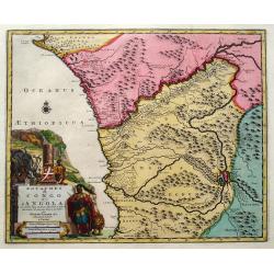
Royaumes de Congo et d'Angola...
Scarce regional map centered on the Zaire river. Extends from about Port Gentil to Lobito. With several place names mainly along the Congo River. With a very large title ...
Date: Leiden, 1720
Selling price: ????
Please login to see price!
Sold in 2018
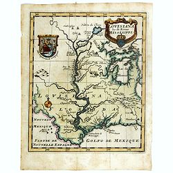
Louisiana by de Rivier Mississippi.
Scarce map of the Mississippi River Valley and Great Lakes regions. The map is primarily based on Hennepin with enlarged Great Lakes and the Mississippi located too far w...
Date: Amsterdam, ca. 1720
Selling price: ????
Please login to see price!
Sold in 2016
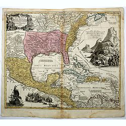
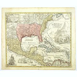
Regni Mexicani seu Novae Hispaniae, Floridae, Novae ..
The map shows the eastern sea board of America, the West Indies and the various estates and countries that border the Gulf of Mexico, with decorative, uncolored cartouche...
Date: Nuremberg, 1720
Selling price: ????
Please login to see price!
Sold in 2016
![[2 maps] Carte des Couronnes du Nord Dédiée au .... CHARLES XII, ROY](/uploads/cache/38418-250x250.jpg)
[2 maps] Carte des Couronnes du Nord Dédiée au .... CHARLES XII, ROY
A large two sheet map of the Baltic, Sweden and Norway by G. de Lisle. Delisle was an important French cartographer of the early 18th century. He held the position of Fir...
Date: Paris , ca. 1720
Selling price: ????
Please login to see price!
Sold in 2018
Regni Mexicani seu Novae Hispaniae, Floridae, Novae ..
The map shows the eastern sea board of America, the West Indies and the various estates and countries that border the Gulf of Mexico, with decorative -uncolored- cartouch...
Date: Nuremberg, 1720
Selling price: ????
Please login to see price!
Sold in 2016
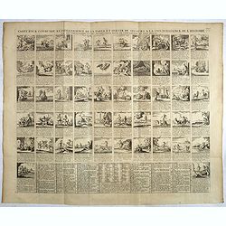
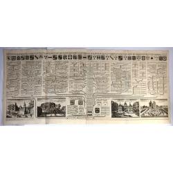
Carte pour conduire a l'intelligence de la fable et servir de secours a la connoissance de l'Histoire . . .
A magnificent display of 52 images of moral fables. From Chatelain's Atlas Historique, 1732-1739. In upper right margin: 'Tom. 7. No 26.Henri Abraham Chatelain (1684 – ...
Date: Amsterdam, ca. 1720
Selling price: ????
Please login to see price!
Sold in 2017
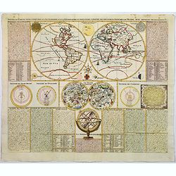
Nouvelle Carte pour conduire a l'Astronomie et a la Geographie. . .
A very decorative double hemisphere map of the world, surrounded by various astronomical models. The models surrounding the earth include a solar system, Kirchers's model...
Date: Amsterdam, ca 1720
Selling price: ????
Please login to see price!
Sold in 2018
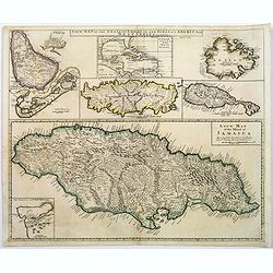
A new map of the English Empire in the Ocean of america or West Indies.
This fine English map of the islands Jamaica, Bermuda, Barbados, Antigua, St.Christopher, Tobago and a inset map of the Caribbean in top.John Senex's A New General Atlas ...
Date: London, 1720
Selling price: ????
Please login to see price!
Sold in 2018
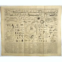
Carte pour contribuer a indiquer la connoissance des premiers principes de fortifications. . .
Decorative military copperplate engraving showing fortifications, armour, etc. From Chatelain's monumental 7 volume "Atlas Historique".Henri Abraham Chatelain (...
Date: Amsterdam, 1720
Selling price: ????
Please login to see price!
Sold in 2017
Carte du blazon ou la science de la noblesse avec des instructions pour conduire a cette connaissance.
Decorative heraldic page with in bottom samples of hats and crowns worn by various ranks of nobility and church leaders. From Chatelain's monumental 7 volume "Atlas ...
Date: Amsterdam, 1720
Selling price: ????
Please login to see price!
Sold in 2018
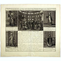
Portraits du Moufti & autres Gens de Loi de l'Empire Ottoman . . .
Four full-length portraits of Turkish costumes, each with a descriptive engraved text: a Mufti, an scholar of Islamic law. An Emir, a commander, here described as a desce...
Date: Amsterdam, 1720
Selling price: ????
Please login to see price!
Sold in 2018
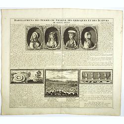
Habillement des femmes de Smyrnes, des Grecques et des Juifs de cette ville.
Four portraits of Smirne women in typical dress, each with a descriptive engraved text. From Chatelain's monumental 7 volume "Atlas Historique".Henri Abraham Ch...
Date: Amsterdam, 1720
Selling price: ????
Please login to see price!
Sold in 2018
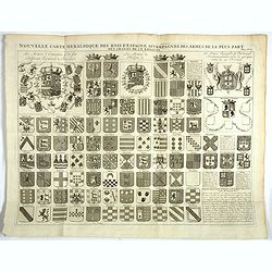
Nouvelle carte heraldique des rois d'Espagne . . .
Decorative sheet with coats of arms of Spanish and Portuguese Kings and noble families.From Chatelain's monumental 7 volume "Atlas Historique".Henri Abraham Cha...
Date: Amsterdam, 1720
Selling price: ????
Please login to see price!
Sold in 2018