Browse Listings
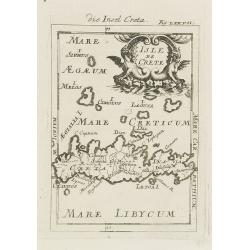
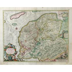
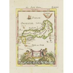
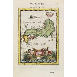
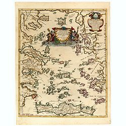
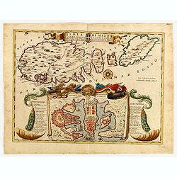
Isle de Crete.
A charming late 17th century map of the Island of Crete. By Allain Manneson Mallet (1630-1706), a well traveled military engineer and geographer who worked in 17th centur...
Date: Frankfurt, 1684
Selling price: ????
Please login to see price!
Sold in 2008
![Isle de la Sonde vers L\'Orient. [Moluccan Islands]](/uploads/cache/26298-250x250.jpg)
Isle de la Sonde vers L\'Orient. [Moluccan Islands]
A charming late 17th century map of the Moluccas Islands. By Allain Manneson Mallet (1630-1706), a well traveled military engineer and geographer who worked in 17th centu...
Date: Frankfurt, 1684
Selling price: ????
Please login to see price!
Sold in 2008
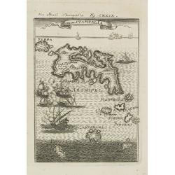
Isle de Stampalia.
A charming late 17th century map of the Stampalia Island. Stampalia is a Greek island which belongs to the Dodecanese, an island group of twelve major islands in the sout...
Date: Frankfurt, 1684
Selling price: ????
Please login to see price!
Sold in 2011
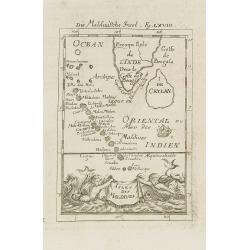
Isles de Maldives.
A charming late 17th century French map of the Maldives Islands.From the German text edition published by Davis Zunners. Allain Manneson Mallet (1630-1706), a well travel...
Date: Frankfurt, 1684
Selling price: ????
Please login to see price!
Sold in 2011
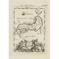
Isles du Japon. / Die Insel Japon.
A charming late 17th century French map of the islands of Japan with a very decorative title cartouche showing trumpet-blowing cherubs.From the German text edition publis...
Date: Frankfurt, 1684
Selling price: ????
Please login to see price!
Sold in 2008
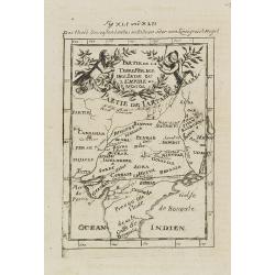
Partie de la Terre Ferme de l\'Inde ou l\'Empire du Mongol.
Map of India. From the German text edition published by Davis Zunners. Allain Manneson Mallet (1630-1706), a well traveled military engineer and geographer who worked in ...
Date: Frankfurt, 1684
Selling price: ????
Please login to see price!
Sold in 2011
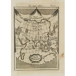
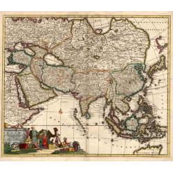
Asie Moderne.
A charming late 17th century French map of Asia.From the German text edition published by Davis Zunners. Allain Manneson Mallet (1630-1706), a well traveled military engi...
Date: Frankfurt, 1684
Selling price: ????
Please login to see price!
Sold in 2008
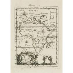
Afrique Moderne.
A charming late 17th century French map of Africa. From the German text edition published by Davis Zunners. Allain Manneson Mallet (1630-1706), a well traveled military e...
Date: Frankfurt, 1684
Selling price: ????
Please login to see price!
Sold in 2008
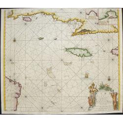
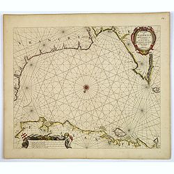
Pas kaart van de Zuyd kust van Cuba en van Geheel Yamaica
Fine sea chart covering the southern part of Cuba, all of Jamaica and the western tip of Hispaniola and a bit of the Honduras coastline Insets of "Baya Oristan in Ya...
Date: Amsterdam, c.1684
Selling price: ????
Please login to see price!
Sold in 2010
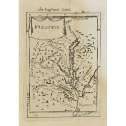
Virginie.
Charming miniature map of the Chesapeake Bay region locating the colony at Jamestown and the village of Pomejok.Several Indian tribes named including Powhatan. Title in c...
Date: Frankfurt, 1684
Selling price: ????
Please login to see price!
Sold in 2008
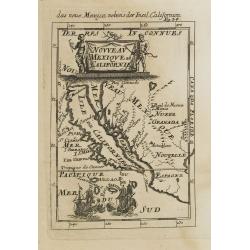
Nouveau Mexique et Californie.
A charming late 17th century French map of California, Nueva Granada and Nouvelle Espagne. California with flat northern coast, labeled Isle de Calfornie. A unique projec...
Date: Frankfurt, 1684
Selling price: ????
Please login to see price!
Sold in 2008
Nieuwe Paskaert, Van de Kust Van Genehoa als Medeen gedeelte van Gambia, beginnende an C. Blanco tot C. Verde, Met al syn diep ten end droogten, dus Ver Naeukeurig op gestelt.
Nice chart, showing the coast of Africa, from Cabo Blanco till Cabo Verde (Dakar) and Gambia River. The Dutch firm and printing house van Keulen was one of the most impor...
Date: Amsterdam, 1684
Selling price: ????
Please login to see price!
Sold in 2009
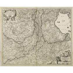
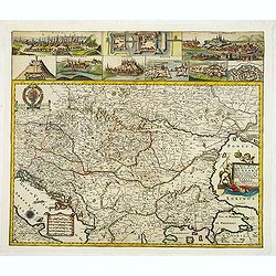
Novissima Comitatus Zutphaniae, Totiusque Fluminis Insulae Descriptio, ex Officina Nicolai Visscher.
Map of the province of Gelderland in the Netherlands. Taken from the atlas Germania Inferior, sive XVII Provinciarum Geographicae generales ut et particulares tabulae. Ka...
Date: Amsterdam, 1684
Selling price: ????
Please login to see price!
Sold in 2009
![[Title page ] Germania Inferior Sive XVII Provinciarum Geographicae Generales ut et particulares Tabulae. Kaert-Boeck van de XVII Nederlandtsche Provincien.](/uploads/cache/26693-250x250.jpg)
[Title page ] Germania Inferior Sive XVII Provinciarum Geographicae Generales ut et particulares Tabulae. Kaert-Boeck van de XVII Nederlandtsche Provincien.
Copper engraved allegorical title page. The 17 Provinces are here personified as 17 beautiful young women, some holding the shields of the Province they represent. Other ...
Date: Amsterdam, 1684
Selling price: ????
Please login to see price!
Sold in 2009
Ducatus Geldria et Zutphania Comitatus.
Map of Gelderland. West to the top. Taken from the atlas Germania Inferior, sive XVII Provinciarum Geographicae generales ut et particulares tabulae. Kaert-Boeck van de X...
Date: Amsterdam, 1684
Selling price: ????
Please login to see price!
Sold in 2009
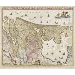
Comitatus Hollandiae Tabula Pluribus Locis Recens Emendata.
Third state of 5) of this popular map of Holland, copied by F. de Wit, J. Danckerts and C. Allard and P. Schenk up to late in the 18th century. Bottom left corner an inse...
Date: Amsterdam, 1684
Selling price: ????
Please login to see price!
Sold in 2010
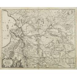
Transisalania Provincia vulgo Over-Yssel. Auctor. N. ten-Have.
Map of central part of the Netherlands with relief shown pictorially. With a decorative cartouche, showing a fisherman, typical for Claes Jansz. Visscher's maps. Prepared...
Date: Amsterdam, 1684
Selling price: ????
Please login to see price!
Sold in 2009
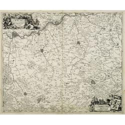
Limburgi Ducatus et Comitatus Valckenburgi Nova Descriptio Per N. Visscher.
The map describes the southern part of Limburg and reaches into Belgium (Liege, Verviers) and Germany (Aachen). The map has two decorative cartouches, etched by Mr. Romey...
Date: Amsterdam, 1684
Selling price: ????
Please login to see price!
Sold in 2018
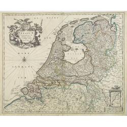
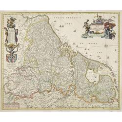
Belgium Foederatum emmendatè auctum et novissimè editum per Nicolaum Visscher.
A well detailed map of the present day Netherlands. The most southern part of Limburg in an inset, lower right corner. Taken from the atlas Germania Inferior, sive XVII P...
Date: Amsterdam, 1684
Selling price: ????
Please login to see price!
Sold in 2013
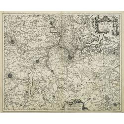
Mechlinia Dominium et Aerschot Ducatus Auctore Nicolao Visscher.
Fine decorative map of part of Belgium including the cities of Antwerp, Mechelen, Brussels, Leuven and Tienen. Taken from the atlas Germania Inferior, sive XVII Provincia...
Date: Amsterdam, 1684
Selling price: ????
Please login to see price!
Sold in 2015
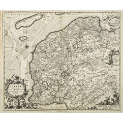
Dominii Frisae Tabula, inter Flevumrt Lavicam, Auctore B. Schotano à Sterringa. Ex Officina Nicolai Visscher.
Map of the provinces Friesland. This map was prepared by B.Schotanus à Steringa. Taken from the atlas Germania Inferior, sive XVII Provinciarum Geographicae generales ut...
Date: Amsterdam, 1684
Selling price: ????
Please login to see price!
Sold in 2010
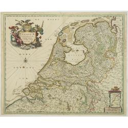
Belgium Foederatum emmendatè auctum et novissimè editum per Nicolaum Visscher.
A well detailed map of the present day Netherlands. The most southern part of Limburg in an inset, lower right corner. Taken from the atlas Germania Inferior, sive XVII P...
Date: Amsterdam, 1684
Selling price: ????
Please login to see price!
Sold in 2017
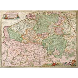
Novissima et accuratissima XVII Provinciarum Germaniae Inferior Delineatio, Ex Officina Nicolai Visscher.
Map of Belgium, the Netherlands and Luxembourg with a decorative title cartouche and cartouche of explanations and a dedication to Johan Munter. North orientated to the r...
Date: Amsterdam, 1684
Selling price: ????
Please login to see price!
Sold in 2009
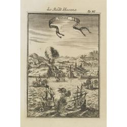
Havana.
Handsome of Havana and its harbour, assaulted by several vessels. Title garland on top.From the French text edition of Description d'Univers, 1683. by Allain Manneson Ma...
Date: Frankfurt, 1684
Selling price: ????
Please login to see price!
Sold
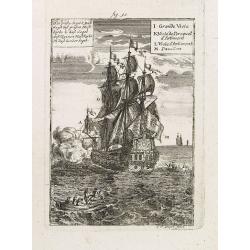
Das grosse Segel. . .
Maritime scene of a vessel with its key: J-M by Allain Manneson Mallet (1630-1706), a well traveled military engineer and geographer who worked in 17th century France und...
Date: Frankfurt, 1684
Selling price: ????
Please login to see price!
Sold in 2014
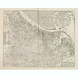
Belgii Regii Tabula, in qua omnes Provincia ab Hispanis ad Annum 1684 possessae, nec nontam a Rege Galliea quam Batavis acquifitae. . .
Beautifully colored map of present day Belgium, northern France, Luxembourg and the Netherlands from Visscher's Germania Inferior. Paris and Luxembourg are shown in the s...
Date: Amsterdam, 1677-1684
Selling price: ????
Please login to see price!
Sold in 2010
Dominii Frisia Tabula, inter Flevum et Lavicam.
Map of Friesland, a northern province of the Netherlands. The major cities of Friesland, such as Franeker, Leeuwarden and Sneek. The coat of arms of Friesland is depicted...
Date: Amsterdam, 1677-1684
Selling price: ????
Please login to see price!
Sold in 2010
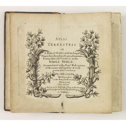
Atlas Terrestris: or a Book of Mapps of all the Empires, Monarchies, Kingdoms, Regions, . . . in the whole World.
One of a series of composite world atlases of varying contents published by John Seller (fl.1658-1698) from 1676 onwards and among one of the very earliest English world ...
Date: London: John Seller, [no date] c. 1684
Selling price: ????
Please login to see price!
Sold in 2010
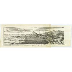
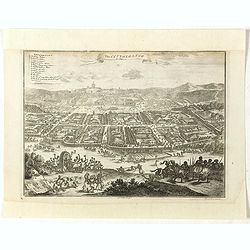
Ofen v. Pest.
Panoramic view of Ofen v. Pest (Budapest). Published in "Der Donau-Strand Mit allen seinen Ein- und Zuflüssen. . .".Published by Jacob Sandrart.
Date: Nuremberg, Jacob Sandrart, 1684
Selling price: ????
Please login to see price!
Sold in 2020
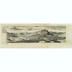
Gran.
Panoramic view of Gran (Esztergom). Published in "Der Donau-Strand Mit allen seinen Ein- und Zuflüssen. . ."Published by Jacob Sandrart.
Date: Nuremberg, Jacob Sandrart, 1684
Selling price: ????
Please login to see price!
Sold
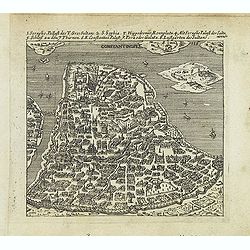
Constantinople.
Uncommon bird's-eye town-plan of Constantinople Published in "Der Donau-Strand mit allen seinen Ein- und Zuflüssen. . ." Published by Jacob Sandrart.
Date: Nuremberg, Jacob Sandrart, 1684
Selling price: ????
Please login to see price!
Sold in 2016
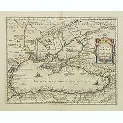
Pontus Euxinus Aequor Iafonio pulfatum remige premum.
Prepared by Ortelius after Mercator, and additional ancient sources as Plinius, Ovidius, Strabo, Apollonius, Procopius and Apianus.This map belongs to a series of histori...
Date: Amsterdam, 1652-1684
Selling price: ????
Please login to see price!
Sold in 2011
Isles du Japon.
A charming late 17th century French map with a very decorative title cartouche showing trumpet-blowing cherubs, by Allain Manneson Mallet (1630-1706), a well traveled mil...
Date: Paris, 1685
Selling price: ????
Please login to see price!
Sold in 2021
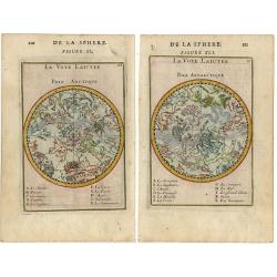
De la sphere (pair of maps).
Pair of small charts each with the constellations in allegorical form featuring the northern and southern sky.
Date: Paris 1685
Selling price: ????
Please login to see price!
Sold
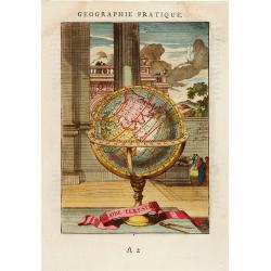
Globe Terestre.
Decorative print of a terrestrial globe. By Allain Manneson Mallet (1630-1706), a well traveled military engineer and geographer who worked in 17th century France under K...
Date: Paris, 1685
Selling price: ????
Please login to see price!
Sold in 2008
Isles du Japon.
A charming late 17th century French map with a very decorative title cartouche showing trumpet-blowing cherubs, by Allain Manneson Mallet (1630-1706), a well traveled mil...
Date: Paris, 1685
Selling price: ????
Please login to see price!
Sold in 2013
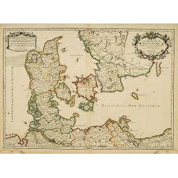
Le Royaume de Danmark subdivisé en ses Principales Provinces..
A decorative map of Denmark prepared by N.Sanson and published by Hubert Jaillot.
Date: Paris 1685
Selling price: ????
Please login to see price!
Sold
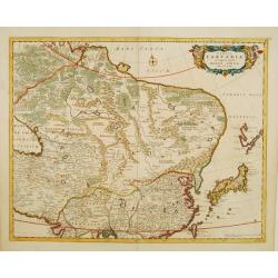
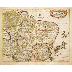
Tabula Tartariae et majoris partis Regni Chinae
Nice map of the region from the Caspian Sea through China and Japan. Eastern Russia is truncated with no Kamchatka peninsula and Yedso is shown according to the voyages o...
Date: Amsterdam 1685
Selling price: ????
Please login to see price!
Sold
Exactissima Asiae delineatio
An attractive full color example of Danckerts scarce map of Asia and the Northern part of Australia based on De Wit. The map extends North to the unknown coasts of Yesso ...
Date: Amsterdam, 1685
Selling price: ????
Please login to see price!
Sold
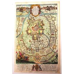
Vienne en Austriche
A scarce, uncommon bird's-eye view of the fortified city of Vienna and surrounding area. Superb detail of streets and individual buildings. Fortifications include walls a...
Date: Paris, ca. 1685
Selling price: ????
Please login to see price!
Sold
Nieuwe Pascaart waar in vertoont wert de Baij van Cadix In't groot.
An important sea-chart of the coast and island of Cadiz. With plate number 30 in lower right corner. Large title cartouche, with title in Dutch and French and a dedicatio...
Date: Amsterdam, 1685
Selling price: ????
Please login to see price!
Sold
Tabula Tartariae et majoris partis Regnis Chinae.
Frederick de Wit (1610-1698) became after the closing of the Blaeu firm one of the most important Amsterdam-based publishers. He published several atlases, Atlas Minor (1...
Date: Amsterdam, c. 1685
Selling price: ????
Please login to see price!
Sold in 2013
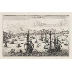
Die Statt Malacca in Indien.
Panoramic town-view of Malacca, published in Wagner, "Delineatio Provinciarum Pannoniae". Unsigned engraving. The engravings for Wagner's book were executed by ...
Date: Augsburg, Koppmayer, 1685
Selling price: ????
Please login to see price!
Sold in 2016
A chart of the trading part of the East Indies and China with the adjaccent islands of Surrat to Japan. . .
In upper part a fine title cartouche with the names of John Thornton, John Seller, William Fisher, James Atkinson and John Colton. With inset map (63x136mm) of Japan. Cov...
Date: London, 1685
Selling price: ????
Please login to see price!
Sold in 2010
Comitatus Namurci Emendata Delineatio Nuperrine in Lucem.
Map by Nicholas Visscher of the area around the Belgium city of Namur from Philipville to Huy and Charlemont. This map includes major cities such as Buillon, Fontaine and...
Date: Amsterdam, 1685
Selling price: ????
Please login to see price!
Sold in 2010
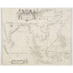
![[Lot of 6 maps of the eastern Mediterranean] Estats / du Grand Seigneur / des Turcs / en Europe, en Asie et en Afrique](/uploads/cache/18520-250x250.jpg)
[Lot of 6 maps of the eastern Mediterranean] Estats / du Grand Seigneur / des Turcs / en Europe, en Asie et en Afrique
An attractive large-format map showing the Turkish empire in Europe, Asia and Africa, comprising the eastern Mediterranean and the Near East. Embellished with a large t...
Date: Amsterdam, c. 1685
Selling price: ????
Please login to see price!
Sold in 2022
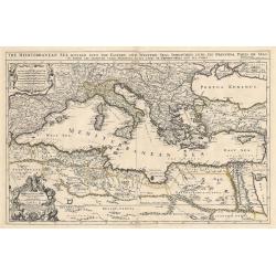
Mediterranean Sea divided into its Principall Parts of Seas
This marvelous very rare map depicts the Mediterranean Sea including its entire coastline, and much of the Ottoman Empire as it was in the late 17th century.The map is de...
Date: London, 1685
Selling price: ????
Please login to see price!
Sold in 2023
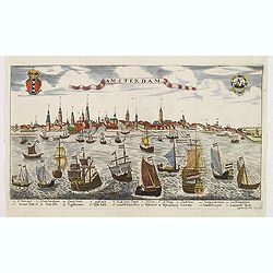
Amsterdam.
A rare panoramic view of the city of Amsterdam from 't IJ, with keys numbered from 1-21 to the principal buildings. A very decorative print with extensive shipping. Etchi...
Date: Augsburg, ca. 1685
Selling price: ????
Please login to see price!
Sold in 2012
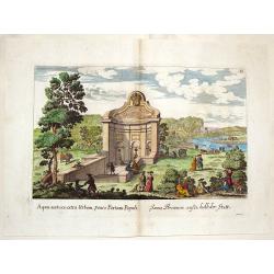
Aqua Acetosa Extra Urbem, Penes Portam Populi.
Pleasing copperplate print of a baroque Roman fountain by Giovanni Falda from the book "Le Fontaine di Roma", published by Froberger for Sandrart in 1685.
Date: Nuremberg, 1685
Selling price: ????
Please login to see price!
Sold in 2013
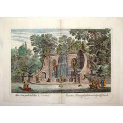
Alius Sons Praedictae Villae a Frescada.
Fine hand-colored engraving of a very fancy fountain at the Villa Frescada in Rome. It features 18 people and two dogs visiting the fountain. Giovanni Battista Falda (...
Date: Rome, 1685
Selling price: ????
Please login to see price!
Sold in 2015
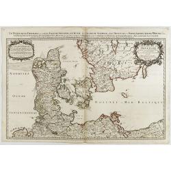
Le Royaume de Danmark..
A decorative map of Denmark prepared by N.Sanson and published by Hubert Jaillot.
Date: Paris, 1685
Selling price: ????
Please login to see price!
Sold in 2014
Arcipelago Mar Egeo con le coste del medesimo...
Giacomo Rossi's fine late 17th century map of the Greek Islands. Issued in Il Mercurio geografico In upper right dedicational cartouche, and in the center a tittle cartou...
Date: Rome, 1685
Selling price: ????
Please login to see price!
Sold in 2015
Groningae et Omlandiae Dominium vulgo De Provincie van Stadt en Lande, cum subjacent. Territ. Praefect. Et Tractibus. [Lud Tjarda â Starckenburg Nicol:Visscher. (P)
Detailed map of the northern Dutch region of Groningen with figurative cartouche and coats of arms. The town of Groningen in the center, Emden just on the right. Engraved...
Date: Amsterdam, 1685
Selling price: ????
Please login to see price!
Sold in 2015
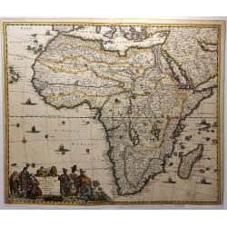
Africae Accurata Tabula ex officina Ioan: De Ram.
A copper engraved map. Overall size 52 x 61 cm.A rare map of the African continent by Johannes de Ram (1648-1693), after de Wit's map of 1660 without the side panels but ...
Date: Amsterdam, ca. 1685
Selling price: ????
Please login to see price!
Sold in 2016
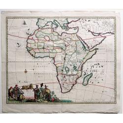
Totius Africae Accuratissima Tabula.
A striking, skilfully engraved, and highly decorative map of the whole continent of Africa, including the island of Madagascar. Much of the information on the map is imag...
Date: Amsterdam, 1685
Selling price: ????
Please login to see price!
Sold in 2018
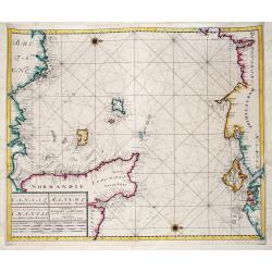
Nieuwe Zeekaart van het Tweede gedeelte van het Canaal Tusschen Engeland en Vrankryk. / ...Chanell betwext England and France.
A detailed chart of the Channel with the coasts of Normandy and part of Bretagne with Guernsy and Jersey and the south coast of England between Chichester and Exmouth wit...
Date: Amsterdam, ca 1685
Selling price: ????
Please login to see price!
Sold in 2019
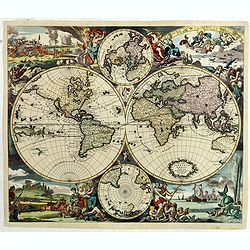
Nova Totius Terrarum Orbis Tabula. . .
Sometime after 1684, when a privilege was granted to the Danckerts firm, a new plate was engraved to replace the single-sheet world map of 1680. The outer decoration is v...
Date: Amsterdam, 1685
Selling price: ????
Please login to see price!
Sold in 2018
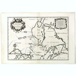
Partie de la Nouvelle France. . .
FIRST EDITION: 1685 map with the Southwest coast of the Hudson's Bay from Port Nelson to Albany (Anglois') was well known from fir trading but further north was mere conj...
Date: Paris, 1685
Selling price: ????
Please login to see price!
Sold in 2019
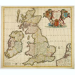
Novissima et Accuratissima Totius Angliae Scotiae et Hiberniae. . .
This is a rare Danckerts edition, of a large decorative map of the British Isles that is filled with excellent detail on towns and counties. It is funrnished with a strik...
Date: Amsterdam ca 1685
Selling price: ????
Please login to see price!
Sold in 2019
A New Mapp of the Kingdom of Hungary and the States that have been Subject to it, which are at Present the Northern Parts of Turkey in Europe
Rare map of Hungary published by Philip Lea. In upper left corner a dedication to George Prince of Denmark and Norway by Richard Palmer. Engraved by R. Palmer, signed low...
Date: London, 1686
Selling price: ????
Please login to see price!
Sold in 2012
Nouvelle Carte Generale des Dix sept Provinces des Pays Bas. 1686
Unrecorded map of the Low Countries with a decorative tittle cartouche upper right corner. This is a reworked plate as remains of previous texts are still visible in the ...
Date: Paris, 1686
Selling price: ????
Please login to see price!
Sold in 2013
The Scenography of a Town & Castle
A very detailed copper engraved city plan published in "The Gentleman's Recreation" in 1686. It shows "the outworks and the manner of carrying on a siege&q...
Date: London - 1686
Selling price: ????
Please login to see price!
Sold in 2013

(Two engravings) The Gentleman's Recreation.
Two copper engraved, hand-colored prints from Richard Blome's "The Gentleman's Recreation".
Date: London, 1686
Selling price: ????
Please login to see price!
Sold in 2016
Geometry, Arts & Science & Phisicks (3 engravings)
Three copper engraved prints from "The Gentleman's Recreation" by Richard Blome. They feature the ancient studies of geometry, physics & arts and science ea...
Date: London, 1686
Selling price: ????
Please login to see price!
Sold in 2013
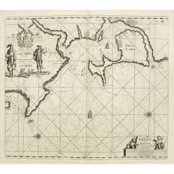
Pas Caart van de Noort Zee Verthoonende in zich Alle de Custen en Havens daer Rontom Gelegen. . .
Scarce nautical panoramicchart of the North Sea, oriented to the West, it shows the coastlines and locations with great details. It has a sequence number 2 in lower right...
Date: Amsterdam, 1686
Selling price: ????
Please login to see price!
Sold in 2013
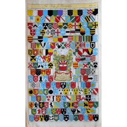
The body of heraldry.
Very attractive and decorative page with 208 shields / coat of arms! Published in "The Gentleman's Recreation" by Richard Blome.
Date: London, c1686
Selling price: ????
Please login to see price!
Sold in 2013
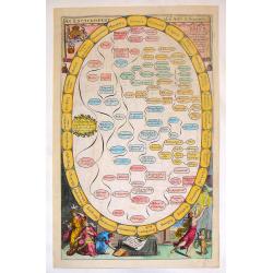
Kurtze Beschreibung von dem Ursprung, Aufnehmen, Gebiete und Regierung der Weltberühmten Republick Venedig.
Short description of the origin, recording, and government areas of the world-famous “Venice Republick.” The first and only edition of this rare work. The copper eng...
Date: Nuremberg, 1686
Selling price: ????
Please login to see price!
Sold in 2015
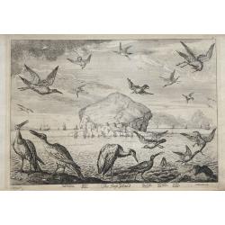
The Bass Island: Soland Goose; Heron; Sea Gull; Wild Duck; Curlew.
The Bass Island etching by Francis Barlow and engraved by Francis Place is from a work dedicated to Richard Maitland, 4th Earl of Lauderdale in 1686. On lined paper with ...
Date: London, 1686
Selling price: ????
Please login to see price!
Sold in 2017
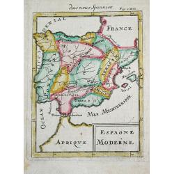
Espagne Moderne.
Alain Manneson Mallet (1603-1706) published in 1683 his ' Description de l' Univers' in 5 volumes. In 1686 a German edition appeared.A map from Alain Manesson Mallet's 'D...
Date: Paris, 1686
Selling price: ????
Please login to see price!
Sold in 2019
Isola Di Malta Gozzo comino e Cominotto...
Giacomo Rossi's fine late 17th century map of Malta and Gozzo. Engraved by Francesco Donia. Issued in Il Mercurio geografico In lower center a decorative cartouche.The ca...
Date: Rome, 1686
Selling price: ????
Please login to see price!
Sold in 2015

Asiae Minoris lacobi cantelly vineolensis...
Giacomo Rossi's fine late 17th century map of Turkey and Cyprus. Issued in Il Mercurio geografico
Date: Rome, 1686
Selling price: ????
Please login to see price!
Sold in 2015
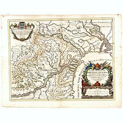
Descritione delli principati della Moldavia e Valachia / tolta da Giacomo Cantelli da Vignola.
Scarce map of the region between the Danube, Nistru, and Dnieper Rivers along the Black Sea - present-day Ukraine and Romania. Excellent detail throughout. Large and deco...
Date: Rome, 1686
Selling price: ????
Please login to see price!
Sold in 2018
La Transilvania, Divisa su l'Esemplare delle Carte migliori e con la direzione delle pius recenti notizie nelle sue Cinque Nationi. . .
Rossi's map of Transylvania, based upon Sanson's map, but with revised Italian nomenclature. The engraver was Giorgio Widman.Issued in a second edition of Il Mercurio geo...
Date: Rome, 1686
Selling price: ????
Please login to see price!
Sold in 2015
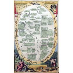
Agriculture, or Husbandry.
Very attractive and decorative page about growing trees, planting herbs, etc. With coat of arms, agricultural tools, and workers. Published in "The Gentleman's Recre...
Date: London, ca. 1686
Selling price: ????
Please login to see price!
Sold in 2015
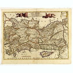
Asiae Minoris lacobi cantelly vineolensis...
Giacomo Rossi's fine late 17th century map of Turkey and Cyprus. Issued in Il Mercurio geografico In upper center a tittle cartouche.The cartographer was Giacomo Cantelli...
Date: Rome, 1686
Selling price: ????
Please login to see price!
Sold in 2016
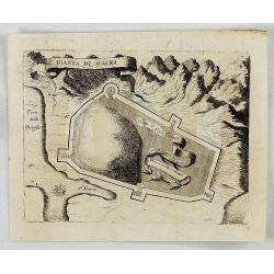
Pianta di Maina.
An interesting map showing the ruins of the fortress in ancient Cersapoli. Tall mountains in the background with a ribbon title cartouche. By Coronelli in Venice in 1686....
Date: Venice, 1686
Selling price: ????
Please login to see price!
Sold in 2018
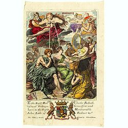
(Dedication page) The Gentleman's Recreation.
Hand-colored allegorical print from Richard Blome's "The Gentleman's Recreation", titled "PAINTING" which was dedicated to Charles Bodwell, Viscount B...
Date: London, 1686
Selling price: ????
Please login to see price!
Sold in 2021
De Zee Custen van Vrancryck tusschen Swartenes en C.de la Hague, Als mede de Custen van Engelandt. . .
A decorative late seventeenth century sea chart by Doncker, showing the south coast of England from Sandwich (Kent) to Portland Bill (Dorset), and the French coastline fr...
Date: Amsterdam, ca 1686
Selling price: ????
Please login to see price!
Sold in 2018
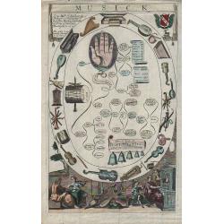
Musick.
From full title, The Gentleman’s Recreations: In Three Parts. The Full Part contains A Short and Easie Introduction to all the Liberal Arts and Sciences, &c. The Se...
Date: London, 1686
Selling price: ????
Please login to see price!
Sold in 2018
The city of Loango from Dapper.
Copper engraved page view of Loango from Olfert Dapper. The view shows the city of Loango capital of the kingdom of the same name which lay in what is now the Republic of...
Date: Amsterdam, 1686
Selling price: ????
Please login to see price!
Sold in 2019