Browse Listings
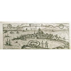
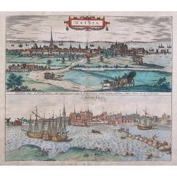
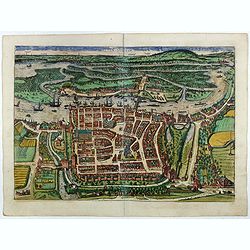
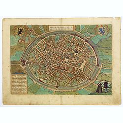
Rotterdam / Roterodamum Hollandiae Opp.
Large and detailed birds-eye view of Rotterdam, with figures in the foreground, and the harbour and city behind. With sailing ships, windmills, numerous buildings, and th...
Date: Cologne, c1588
Selling price: ????
Please login to see price!
Sold in 2012
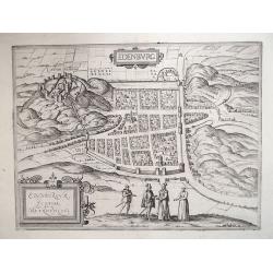
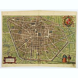
EDENBURG / EDENBURGUM, SCOTIAE METROPOLIS 1588
From an engraving in Ralph Holished’s Chronicles [1574], the Scottish Capital of Edinburgh during the reign of Mary Queen of Scots. Viewed from the South, it includes t...
Date: Cologne, 1588
Selling price: ????
Please login to see price!
Sold in 2012
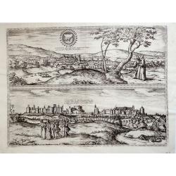
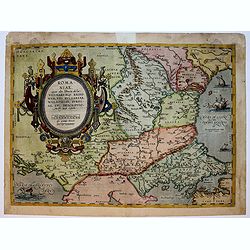
Oxonium nobile Anglie oppidum...; Vindesorium celeberrimum Anglie castrum... 1588
Decorative pair view of Oxford and view of Windsor Castle, from Braun & Hogenberg's "Civitatus Orbis Theatrum", the most famous atlas of city views publishe...
Date: Cologne, 1588
Selling price: ????
Please login to see price!
Sold in 2012
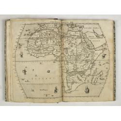
Livio Sanuto. Geografia di M. Livio Sanvto distinta in XII libri. Ne' quali, oltra l'esplicatione di molti luoghi di Tolomeo e della Bussola, ...
Livio Sanuto. Geografia di M. Livio Sanvto distinta in XII libri. Ne' quali, oltra l'esplicatione di molti luoghi di Tolomeo e della Bussola, e dell' Aguglia; si dichiara...
Date: Venice, Damiano Zenaro, 1588
Selling price: ????
Please login to see price!
Sold in 2019
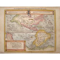
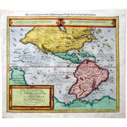
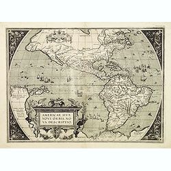
Americae Sive Novi Orbis Nova Descriptio. Die newen inseln so hinder Hispaniam gegen Orient, bey dem landt Indie gelegen
Nicely colored map of North and South America. Two elongated oval cartouches across the top with gothic German text and a finely decorated title cartouche to the bottom l...
Date: Basle, Henri Petrie, 1588
Selling price: ????
Please login to see price!
Sold in 2013
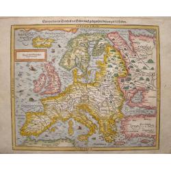
Europa, das ein drittheil der erden, nach gelegenheit unserer zeit beschrieben.
Decorative full color example of Munster's final map of Europe, from a German edition of Munster's Cosmographia, one of the most influential geogaphical works of the 16th...
Date: Basle, S. H. Petrie, 1588
Selling price: ????
Please login to see price!
Sold in 2013
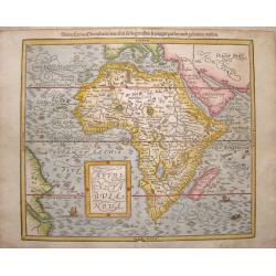
Africae tabula nova / Africa, Lybia, Morenlandt, mit allen Königreichen so jetziger zeit darumb gefunden werden. . .
Attractive woodcut map showing the African continent. From the 1588-German edition of Cosmographia by Sebastian Münster. German text on verso. This woodblock map is eleg...
Date: Basle, S.H. Petrie, 1588
Selling price: ????
Please login to see price!
Sold in 2014
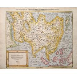
Asia wie es Jetziger Zeit nach den Furnemesten Herrschafften Abgetheilet und Beschriben ist .
Nice full color example Sebastian Munster's second map of Asia, first published in 1588.It is filled with numerous small woodcut vignettes of towns and a lone sea monster...
Date: Basle, S. H. Petrie, 1588
Selling price: ????
Please login to see price!
Sold in 2013
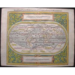
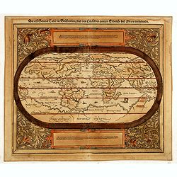
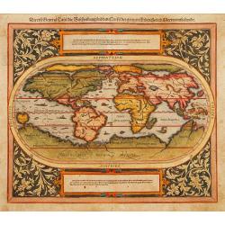
Die erst General Tafel, die Beschreibung und den Circkel des gantzen Erdreichs und meers innhaltende. . .
Lovely full color example Sebastian Münster's oval map of the World, first published in 1588. It is filled with small monsters, sailing ships and fishing boats in the se...
Date: Basle, 1588
Selling price: ????
Please login to see price!
Sold in 2014
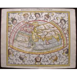
Ptolemeisch General Tafel, die halbe Kugel der Welt begreissende. . .
Lovely full color example Sebastian Münster's Ptolemaic world map, a redrawn map published in 1588. Relief is shown pictorially. The woodcut technique with its insertio...
Date: Basle, 1588
Selling price: ????
Please login to see price!
Sold in 2014
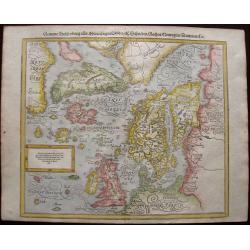
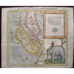
Gemeine Beschreibung aller Mitnachtigen Lander/ alsz Schweden / Gothen / Norwegien / Dennmark &c
Interesting wood block printed map of Europe, Scandinavia, England, Denmark, Norway, Sweden, Iceland, The Baltics, Greenland, and America.The map shows two Greenlands, on...
Date: Basle, 1588
Selling price: ????
Please login to see price!
Sold in 2014
![[Europe] Europa das ein Drittheil der Erde nach gelegenheit unserer zeit beschrieben.](/uploads/cache/34182-250x250.jpg)
[Europe] Europa das ein Drittheil der Erde nach gelegenheit unserer zeit beschrieben.
Decorative example of Munster's final map of Europe, from a German edition of Munster's Cosmographia, one of the most influential geographical works of the 16th Century. ...
Date: Basle, S.H.Petri, 1588
Selling price: ????
Please login to see price!
Sold in 2014
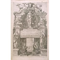
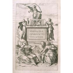
Title page from Civitatus Orbis Terrarum vol. 3
Lavish, decorative title page from Georg Braun and Franz Hogenberg great 16th century atlas of town and city views.
Date: Frankfurt, c1588
Selling price: ????
Please login to see price!
Sold in 2014
Title page from Civitatus Orbis Terrarum vol.4.
Decorative title page from the fourth edition of Braun and Hogenberg's lavishly illustrated 16th century town book.
Date: Frankfurt c.1588
Selling price: ????
Please login to see price!
Sold in 2014
Die erste General Tafel.
The title is in gothic German and the corners are decorated by a florid vineleaf pattern. Modern world map after Ortelius.
Date: Basle, 1588
Selling price: ????
Please login to see price!
Sold in 2014
Das Heilig Landt mit Ausztheilung der Zwolff Geschlechter.
Classic woodblock map of the region showing numerous towns along the fertile coast and mountains, rivers and lakes. Although the title mentions the 12 tribes, they are no...
Date: Basle, S.H. Petrie, 1588
Selling price: ????
Please login to see price!
Sold in 2014
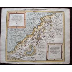
Syria, Cypern, Palestina, Mesopotamia, Babylonia, zwey Arabia mit Bergen, Waesseren und Stetten.
A famous woodblock map of the Near East, including Cyprus, Palestine, Iran, Iraq, etc. From his 'Cosmographia,' that great compendium of Renaissance knowledge. In 1588, n...
Date: Basle, S.H. Petrie, 1588
Selling price: ????
Please login to see price!
Sold in 2014
Sumatra ein Grosse Insel so von den Alten Geographen Taprobana Genennet Worden.
Early, desirable map of the island of Sumatra and the southern part of Malaysia. It is one of the earliest maps to focus on this region. Shown near today's Singapore on t...
Date: Basle, S.H. Petrie, 1588
Selling price: ????
Please login to see price!
Sold in 2014
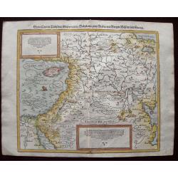
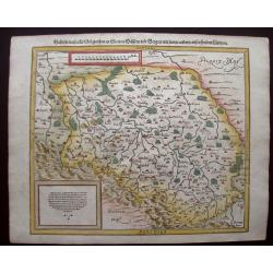
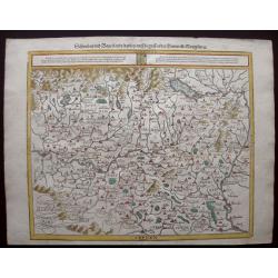
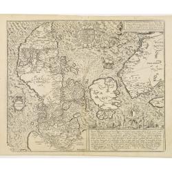
Landtafel des Ungerlands, Polands, Reussen, Littaw, Walachen und Bulgaren.
Early edition Munster's map of Poland, Lithuania, the Ukraine, Moscovy and the Balkans, extending from Prussia, Vilna and Smolensky in the north to Bosnia, Bulgaria, Cons...
Date: Basle, 1588
Selling price: ????
Please login to see price!
Sold in 2014
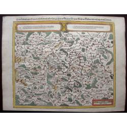
Bohemer Koenigreich mit Bergen und Waelden gerings umb beschlossen.
Detailed map of Bohemia, centered on Prague, from the 1588-German edition of Munster's Cosmography. Mountains, villages, churches and woods are attractively drawn pictori...
Date: Basle, S.H. Petrie, 1588
Selling price: ????
Please login to see price!
Sold in 2020
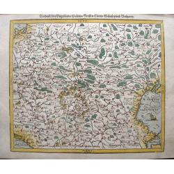
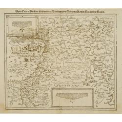
Franckenlandt am Mayn, beschriben nach aller Gelegenheit, in Stetten, Bergen, Wässern, Wäldern, und anstossenden Ländern
Detailed map of Southern Germany around the river Main, from the 1588-German edition of Munster's Cosmography. Mountains, villages, churches and woods are attractively dr...
Date: Basle, S.H. Petrie, 1588
Selling price: ????
Please login to see price!
Sold in 2019
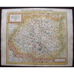
Schlesia nach aller Gelegenheit / in stetten / wassern und bergen / mit sampt andern anstossenden Laendern.
An attractive woodblock map centered on Bresla (Wroclaw) with pictorial representations of forests, towns and mountains. The region is Silesia, Poland. German text and il...
Date: Basle, S.H. Petrie, 1588
Selling price: ????
Please login to see price!
Sold in 2021
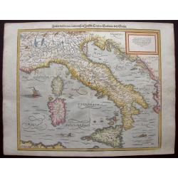
Italia Mit Den Dreyen Furnempften Inseln / Corsica / Sardinia / und Sicilia
This charming wood block printed map of Italy, Corsica, Sicily and Sardinia was published in the 1588-edition of Sebastian Münster’s Cosmographia. Mountains, villages,...
Date: Basle, S.H. Petrie, 1588
Selling price: ????
Please login to see price!
Sold in 2014
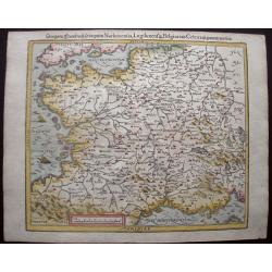
Das gantz Franckreich, so vorzeiten Narbonensis, Lugdunensis, Belgica und Celtica, ist genennt worden.
This nicely colored, charming early woodcut map of France was published in the 1588-edition of Sebastian Münster’s Cosmographia. Mountains, villages, churches and wood...
Date: Basle, S.H. Petrie, 1588
Selling price: ????
Please login to see price!
Sold in 2014
Teutschlandt mit seinem gantzen begriff und eingschlosznen Landschafften.
Early Munster's map of Germaniae or Northern Europe. The map is south-oriented with "west" on the right side and "east" on the left side. Bamberg and ...
Date: Basle, S.H. Petrie, 1588
Selling price: ????
Please login to see price!
Sold in 2014
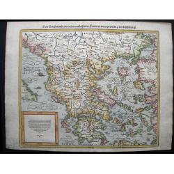
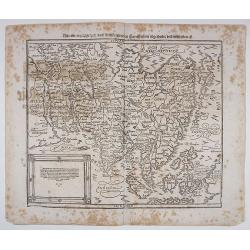
New Griechenlandt / mit andern anstossendener Landern / wie es zu unsern zeiten beschribenist.
Nicely colored and fascinating 1588 map of Greece and the western part of Turkey. After many new discoveries and explorations, by 1588 a new edition of the Cosmographia h...
Date: Basle, S.H. Petrie, 1588
Selling price: ????
Please login to see price!
Sold in 2014
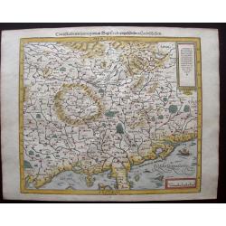
Schwaben und Bayerlandt darbey auch Begriffen der Otenwald, Nortgow.
An attractive early woodcut map A map of Swabia, one of the ten Imperial Circles of the Holy Roman Empire. Orientated with north at the bottom, it marks Strassburg, Bambe...
Date: Basle, S.H. Petrie, 1588
Selling price: ????
Please login to see price!
Sold in 2020
Engellandt / mit dem anstossenden Reich Schottlandt / so vor zeiten Albion und Britannia haben geheissen.
Early map of England and the British Isles. The map is oriented with west at the top and provides a fine early depiction of the British Isles, based upon Ortelius' map of...
Date: Basle, S.H. Petrie, 1588
Selling price: ????
Please login to see price!
Sold in 2014
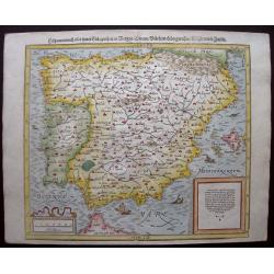
Hispanien nach aller seiner Gelegenheit / in Bergen Stetten / Volkeren Konigreichen Wasseren und Inseln.
Very early map of the Iberian Peninsula with the Baleares to the east. In the Mediterranean and the Ocean are three historic sailing vessels and a spouting sea monster wh...
Date: Basle, S.H. Petrie, 1588
Selling price: ????
Please login to see price!
Sold in 2014
Hafnia vulgo Kopenhagen.
Two fantastic birds-eye views of Copenhagen, one from land and from the seaside showing the harbor. Highly detailed with numerous buildings, windmills, sailing ships, and...
Date: Cologne, ca. 1588
Selling price: ????
Please login to see price!
Sold in 2015
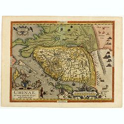
Chinae, olim Sinarum Regionis, nova descriptio. Auctore Ludovico Georgio.
The first map of China ever to appear in a Western atlas, west to the top. When this map appeared, it was by far the most accurate one of China.Japan is shown on a curiou...
Date: Antwerp, after 1588
Selling price: ????
Please login to see price!
Sold in 2015
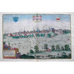
Bethunae urbis Artesiae Genvina Descrip.
An uncommon view of Bethune, located in Pas-de-Calais. Shows the city behinds its walls, with numerous detailed buildings, some named above.The view provides a fine depic...
Date: Cologne, 1588
Selling price: ????
Please login to see price!
Sold in 2016
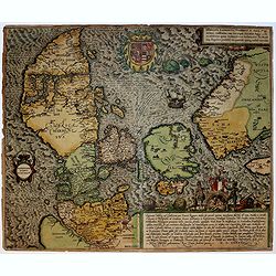
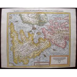
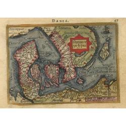
Danorum Marca, uel Cimbricum. aut Daniae Regnum..
The oldest preserved map of Denmark of Danish origin. Drawn by Marcus Jordan at the request of Duke Heinrich Rantzau, viceroy of Schleswig-Holstein. It is a new perceptio...
Date: Cologne, 1588
Selling price: ????
Please login to see price!
Sold in 2016
![NOVESIUM [NEUSS]](/uploads/cache/37623-250x250.jpg)
NOVESIUM [NEUSS]
One of the finest and most sought-after views of Neuss. From volume one of the greatest publication in this genre!. The Civitates was compiled and written by George Braun...
Date: Cologne, 1588
Selling price: ????
Please login to see price!
Sold in 2019
![[Asia Minor]](/uploads/cache/35959-250x250.jpg)
[Asia Minor]
Wood block printed map with German text beneath and to verso of map. Map shows Turkey and many of the Greek Islands, Crete, Cyprus, Syria, Asia Minor and Thracia.
Date: Basle, 1588
Selling price: ????
Please login to see price!
Sold in 2023
Romaniae..
Map of South East Europe. Prepared by Jacob Gastaldi. Including Romania, Bulgaria and in lower right Istanbul. With imposing title cartouche.
Date: Antwerp, 1588
Selling price: ????
Please login to see price!
Sold in 2018
Alten Stettin. (Szczecin)
A stunning bird's-eye view of Szczecin (German: Stettin) in Poland. Published in the 'Civitates Orbis Terrarum', the first series of printed town plans. Frans Hogenberg (...
Date: Cologne, 1588
Selling price: ????
Please login to see price!
Sold in 2016
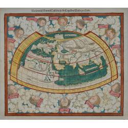
Ptolemeisch General Tafel/die halbe Kugel der Welt begreissende.
A Ptolemaic world map by the German cartographer Sebastian Münster. Ptolemy wrote two major works in the 2nd century, one being the Geographia, the first world atlas. Re...
Date: Basle, ca. 1588
Selling price: ????
Please login to see price!
Sold in 2019
Asia wie es Jetziger Zeit nach den Furnemesten Herrschafften Abgetheilet und Beschriben ist.
Münster’s decorative final map of Asia, from a German edition of Münster’s "Cosmographia", one of the most influential geographical works of the 16th Cent...
Date: Basle, 1588
Selling price: ????
Please login to see price!
Sold in 2018
Brugae Flandricarum Urbium Ornamentia.
The city of Bruges in western Flanders is shown in a plan-like bird's-eye view from a northwesterly direction, ringed by numerous windmills. At the center can be seen the...
Date: Cologne, ca 1588
Selling price: ????
Please login to see price!
Sold in 2020
Bononia Alma Studior Mater.
A beautiful bird's-eye plan of Bologna - seat of sciences. With fortified with moats and walls, the city is seen from the north in this high bird's-eye view. At the cente...
Date: Cologne, ca 1588
Selling price: ????
Please login to see price!
Sold in 2020
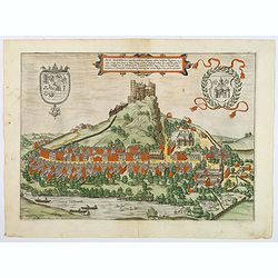
Arx Segeberga. . .
TRANSLATION OF CARTOUCHE TEXT: The castle of Segeberg, formerly Aelberga, embellishes Wagrien, the famous region in Holstein. This our work has been adorned with this vie...
Date: Cologne, ca 1588
Selling price: ????
Please login to see price!
Sold in 2020
Americae Sive Novi Orbis Nova Descriptio. / Die newen inseln so hinder Hispaniam gegen Orient . . .
Sebastian Münster (1489-1552) is one of the most renowned cartographers of the sixteenth century, Mercator and Ortelius are considered at the same level. Munster's two m...
Date: Basle, 1588
Selling price: ????
Please login to see price!
Sold in 2019
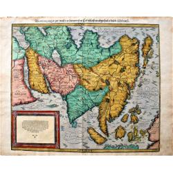
Asia wie es Jetziger Zeit nach den Furnemesten. . .
Sebastian Münster (1489-1552) is one of the most renowned cartographers of the sixteenth century, Mercator and Ortelius are considered at the same level. Munster's two m...
Date: Basle, 1588
Selling price: ????
Please login to see price!
Sold in 2020
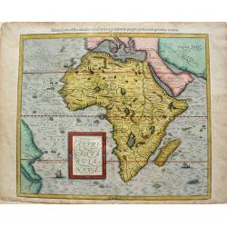
Africae tabula nova / Africa, Lybia, Morenlandt, mit allen Königreichen so jetziger zeit darumb gefunden werden. . .
Sebastian Münster (1489-1552) is one of the most renowned cartographers of the sixteenth century, Mercator and Ortelius are considered at the same level. Munster's two m...
Date: Basle, 1588
Selling price: ????
Please login to see price!
Sold in 2019
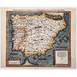
Hispanien nach aller seiner Gelegenheit / in Bergen Stetten / Volkeren Konigreichen Wasseren und Inseln.
A very early map of the Iberian Peninsula with the Balearics to the east. In the Mediterranean and the Ocean are three historic sailing vessels and a spouting sea monster...
Date: Basle, 1588
Selling price: ????
Please login to see price!
Sold in 2019
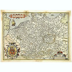
Germania.
An attractive map centered on Germany. The sea is decorated with a vessel and a sea monster.From a rare Spanish text edition.
Date: Antwerp, 1588
Selling price: ????
Please login to see price!
Sold in 2009
World map: Die erste General Tafel.
The title is in gothic German and the corners are decorated by a florid vineleaf pattern. Modern world map after Ortelius.
Date: Basle 1588
Selling price: ????
Please login to see price!
Sold
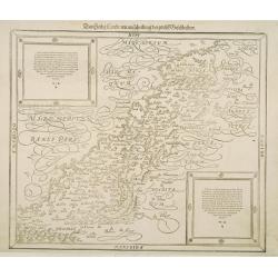
Das Heilig Landt mit auscheilung der zwolff Geschlechter.
The Holy Land as divided among the 12 Tribes. Although the title speaks about the Tribes, they are not shown on the map itself, only the division into Galilee, Samaria an...
Date: Basle 1588
Selling price: ????
Please login to see price!
Sold
Syria, Cypern, Palestina, Mesopotamia..
A famous wood block map of the Near East, including Cyprus, Palestine, Iran and Iraq, etc. From his Cosmographia , that great compendium of Renaissance knowledge. In 1588...
Date: Basle c.1588
Selling price: ????
Please login to see price!
Sold
Danorum Marca, uel Cimbricum. aut Daniae Regnum..
The oldest preserved map of Denmark of Danish origin. Drawn by Marcus Jordan at the request of Duke Heinrich Rantzau, viceroy of Schleswig-Holstein. It is a new perceptio...
Date: Cologne 1588
Selling price: ????
Please login to see price!
Sold
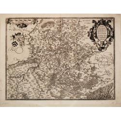
Nobilis Hannoniae Comitatus Descrip. 1579.
Abraham Ortelius(1527-98), Dutch cartographer and publisher of the first modern atlas, ' Theatrum Orbis Terrarum' in 1570. Editions till 1612. Also an atlas of ancient ca...
Date: Antwerp, 1588
Selling price: ????
Please login to see price!
Sold in 2018
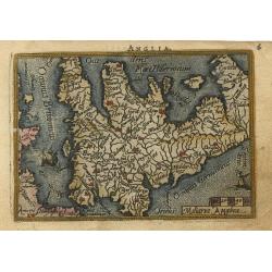
Anglia
Miniature map covering England and Wales. French text on verso. This map is oriented with north to the right. The map is beautifully engraved with stippled seas and ships...
Date: Antwerp, 1588
Selling price: ????
Please login to see price!
Sold
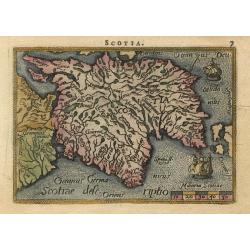
Scotia
Miniature map covering the northern part of England and Scotland. French text on verso. This map is oriented with north to the right. The map is beautifully engraved with...
Date: Antwerp, 1588
Selling price: ????
Please login to see price!
Sold
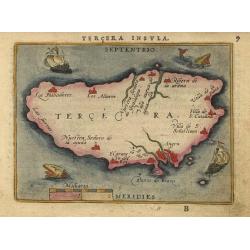
Tercera Insula
Nice miniature map showing the island and the important port of Angra. The map is beautifully engraved with stippled seas and two sailing ships and two tiny sea monsters.
Date: Antwerp, 1588
Selling price: ????
Please login to see price!
Sold
Daniae regni Typus
Miniature map covering Denmark including that part of Sweden that was then controlled by Denmark. The map is beautifully engraved with stippled seas and a sailing ship.
Date: Antwerp, 1588
Selling price: ????
Please login to see price!
Sold
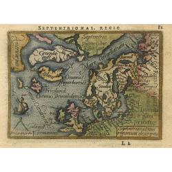
Septentrionalium regionum descriptio
Handsome miniature map based on Ortelius' important map of the Arctic regions with the mythical islands of Drogeo and Frieslant. The map is beautifully engraved with stip...
Date: Antwerp, 1588
Selling price: ????
Please login to see price!
Sold
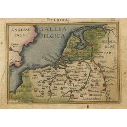
Gallia Belgica.
Miniature map covering Belgium and the Netherlands. The map is beautifully engraved with stippled seas.
Date: Antwerp, 1588
Selling price: ????
Please login to see price!
Sold
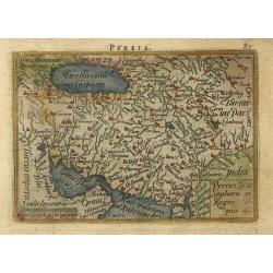
Persia
Nice miniature map showing the Persian Empire. The map is beautifully engraved with stippled seas.
Date: Antwerp, 1588
Selling price: ????
Please login to see price!
Sold
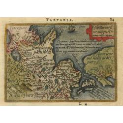
Tartaria sive magni chami regni typus.
This small map is the reduced version of the earliest map to focus on the North Pacific. While designed to illustrate the expansive Kingdom of the Great Khan in Asia, its...
Date: Antwerp, 1588
Selling price: ????
Please login to see price!
Sold
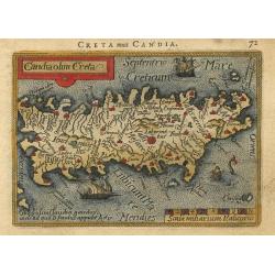
Candia olim Creta
Nice miniature map of the island that shows several place names and the mythological Labyrinth where the Minotaur was confined. The map is beautifully engraved with stipp...
Date: Antwerp, 1588
Selling price: ????
Please login to see price!
Sold
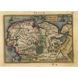
Descript. Frisiae
Charming little map of the northern part of The Netherlands, the Provinces of Friesland, Groningen and part of Drenthe. The map is beautifully engraved with stippled seas...
Date: Antwerp, 1588
Selling price: ????
Please login to see price!
Sold
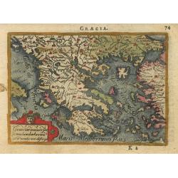
Graecia.
Delightful little map of Greece. The map is beautifully engraved with stippled seas.
Date: Antwerp, 1588
Selling price: ????
Please login to see price!
Sold
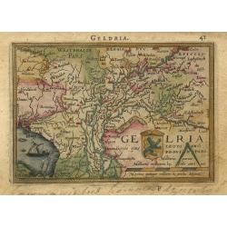
Geldria
Charming little map of a part of The Netherlands, the Province of Gelderland. The map is beautifully engraved with stippled sea and a sailing ship.
Date: Antwerp, 1588
Selling price: ????
Please login to see price!
Sold
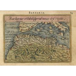
Barbariae et biledulgerid nova descriptio
Miniature map of the Barbary coast and parts of Italy and Spain. The map is beautifully engraved with stippled seas.
Date: Antwerp, 1588
Selling price: ????
Please login to see price!
Sold
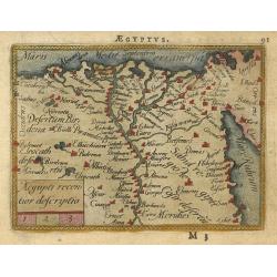
Aegiipti recentior descriptio
Miniature map showing the Nile valley in great detail with numerous place names. The map is beautifully engraved with stippled seas.
Date: Antwerp, 1588
Selling price: ????
Please login to see price!
Sold
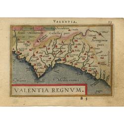
Valentia regnum.
Nice miniature map of Valencia. Latin text on verso.
Date: Antwerp, 1588
Selling price: ????
Please login to see price!
Sold
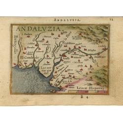
Andaluzia.
Nice miniature map of Andalusia. Latin text on verso.
Date: Antwerp, 1588
Selling price: ????
Please login to see price!
Sold
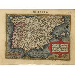
Regni Hispaniae.
Charming miniature map fully engraved with rivers and cities, a stippled sea, strapwork title cartouche and a tiny ship. Latin text on verso.
Date: Antwerp, 1588
Selling price: ????
Please login to see price!
Sold
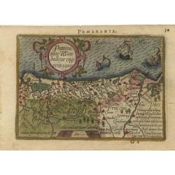
Pomeraniae wandalicae regnionis tipus.
Nice map features Pomerania and is based on the Peter Artopaus map published in 1550 by Sebastian Munster. With a nice title cartouche and 2 monsters in the sea. Latin te...
Date: Antwerp, 1588
Selling price: ????
Please login to see price!
Sold
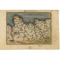
Normandia.
Miniature map of the coast of France at Normandy. Latin text on verso.
Date: Antwerp, 1588
Selling price: ????
Please login to see price!
Sold
Americae Sive Novi Orbis, Nova Descriptio.
Third plate, state 1. In 1587, a new plate was engraved which appeared in editions from 1588 onward. Of the three maps, this one is perhaps the most important. Geographic...
Date: Anvers, 1588
Selling price: ????
Please login to see price!
Sold
Austriae Ducatus Chorographia, Wolfgango Lazio Auctore.
A highly decorative early map of the duchy of Austria, engraved after the cartographic source by Wolfgang Lazius.Centered on the stretch of the Danube from Linz to Bratis...
Date: Antwerp, 1588
Selling price: ????
Please login to see price!
Sold
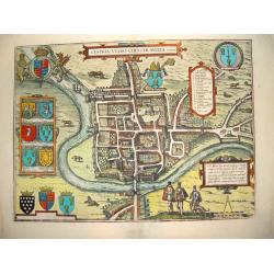
Cestria Vulgo Chester, Angliae Civitas
This desirable, highly decorative depiction presents the city of Chester on the banks of the River Dea. Based on the survey of William Smith, the bird's-eye plan shows th...
Date: Cologne, ca. 1588
Selling price: ????
Please login to see price!
Sold in 2008
![[World map] General Taffel der gantzen Welt.](/uploads/cache/24957-250x250.jpg)
[World map] General Taffel der gantzen Welt.
The title is in gothic German and the corners are decorated by a florid vine leaf pattern. Modern world map after Ortelius.
Date: Basle 1588
Selling price: ????
Please login to see price!
Sold in 2008
![Americae sive Novi Orbis, Nova Descriptio [Spanish text edition]](/uploads/cache/199823-250x250.jpg)
Americae sive Novi Orbis, Nova Descriptio [Spanish text edition]
One of the most famous and decorative maps of America. In 1587, a new plate was engraved which appeared in editions from 1588 onwards. Of the three maps, this one is perh...
Date: Antwerp, (1587) 1588
Selling price: ????
Please login to see price!
Sold in 2011
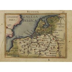
Gallia Belgica.
Miniature map covering Belgium and the Netherlands. The map is beautifully engraved with stippled seas. Hard to find now-a-days in original colors.
Date: Antwerp, 1588
Selling price: ????
Please login to see price!
Sold in 2008
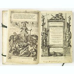
Descrittione di M. Lodovico Guicciardini, gentil- huomo fiorentino, di tutti Paesi Bassi . . .
Italian text edition of this famous description of the Low Countries. The book is illustrated with 53 double page town plans, 12 maps and 13 one page views.Ludovico Guicc...
Date: Antwerp, 1588
Selling price: ????
Please login to see price!
Sold in 2010
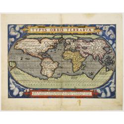
Typus Orbis Terrarum.
A state two (without date) of the second plate of this influential, and famous World map, issued in the first regularly produced world atlas. The map is a careful reducti...
Date: Antwerp, 1588
Selling price: ????
Please login to see price!
Sold in 2010
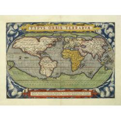
Typus Orbis Terrarum.
An state two (without date) of the second plate of this influential, and famous World map, issued in the first regularly produced world atlas. The map is a careful reduct...
Date: Antwerp, 1588
Selling price: ????
Please login to see price!
Sold in 2010