Browse Listings
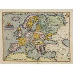
Europae.
Somewhat distorted land masses: vignette of Europe being carried off by the bull (Zeus).The first plate with title AFRICAE PARS in normal lettering. Fine impression.The m...
Date: Antwerp, 1584
Selling price: ????
Please login to see price!
Sold in 2013
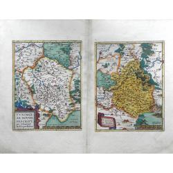
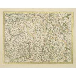
Turingiae Noviss. Descript per Iohannem Mellinger Halens. / Misniae et Lusatiae Tabula.
A pair of maps of central Europe by Abraham Ortelius. The first map on the left is of the region of Eastern Germany, and shows the cities and towns of Erfurt (Erfurdt), ...
Date: Antwerp, 1584
Selling price: ????
Please login to see price!
Sold in 2010
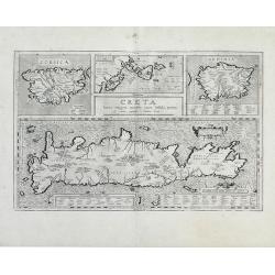
Creta Iouis magni, medio iacet insula ponto.
Fantastic map of islands of the Mediterranean by Ortelius; a large map of Crete is at the bottom half of the sheet, with smaller maps of Corsica, the Greek Islands and Sa...
Date: Antwerp, 1584
Selling price: ????
Please login to see price!
Sold in 2010
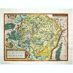
Lutzenburgensis Ducatus veriss descript.
Prepared by Jacob Surhon who made a manuscript map of Luxembourg for which he received 500 Livres from Charles V in 1551. For security reasons the map was not published. ...
Date: Antwerp, 1584
Selling price: ????
Please login to see price!
Sold in 2014
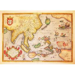
Indiae Orientalis Insularumque Adiacentium Typus.
Finely originally hand colored example of Ortelius' important and highly decorative map of Southeast Asia. The title is set in a decorative strapwork cartouche, coat of a...
Date: Antwerp, 1584
Selling price: ????
Please login to see price!
Sold in 2012
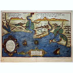
Car Petani Ae Partis Descr/ Gui Pus Coae Regionis Typus / Hanc insulam Perlustrabat, et sua Manu de Pingebat Geor Gius Hoefnagli us Antuerpian. . .
Three maps on one sheet of Cadiz and other regions in Spain. Based on Georg Hoefnagel, who drew a manuscript map during his stay in Spain from 1563 to 1567 (Meurer p. 167...
Date: Antwerp, c.1584
Selling price: ????
Please login to see price!
Sold in 2012
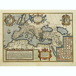
Romanii Imperii Imago.
An attractive map of the second plate prepared (after 1592) of the Roman Empire, drawn by Ortelius and published in the 'Paregon' section. The medallion portraits are of ...
Date: Antwerp, 1584
Selling price: ????
Please login to see price!
Sold in 2012
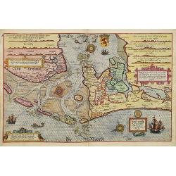
Hollandiae Antiquorum Catthorum Sedis Nova Descriptio . . .
Ortelius' atlas publication of Jacob van Deventer's survey of the province of Holland surveyed in 1537 and published first in Antwerp in nine sheets by Bernard van der Pu...
Date: Antwerp, ca.1584
Selling price: ????
Please login to see price!
Sold in 2012
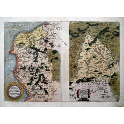
Caletensium Et Bononiensium Ditionis Accurata Delineatio & Veromanduorum Eorum Que Confinium Exactissima Descriptio...
Two detailed regional maps by Ortelius. The first map shows Belgian and French Coastal region, from Etaples to Gravelines, with Calais, Boulogne-sur-Mer. The second map s...
Date: Antwerp, 1584
Selling price: ????
Please login to see price!
Sold in 2013
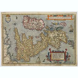
Angliae, scotiae, et Hiberniae, sive Britannicar insularum.
A state 3 of this classic, handsome and decorative map of ancient British Isles with north orientated to the east. Latin text on verso.Based on Mercator's 1564 map of the...
Date: Antwerp, after 1584
Selling price: ????
Please login to see price!
Sold in 2018
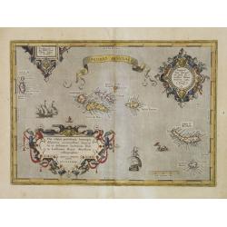
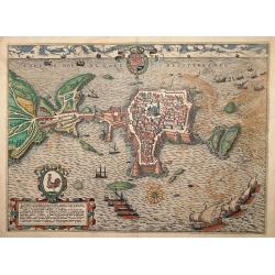
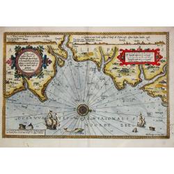
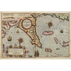
Açores Insulae.
First state. The importance of the Azores at that time was connected with the observation of Columbus that compass variation (i.e. the difference between the real and the...
Date: Antwerp, 1584
Selling price: ????
Please login to see price!
Sold in 2014
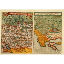
Rhetiae alpestris .. Tirolis Comitatus. & Goritiae. . .
On the left hand-side a map of Tyrol in Austria and on the right a map of the Northern part of Yugoslavia. The maps are prepared by Lazius in 1561.
Date: Antwerp, 1584
Selling price: ????
Please login to see price!
Sold in 2015
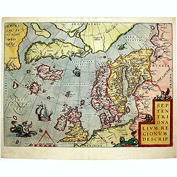
Septentrionalium Regionum Descrip.
This influential map of the Arctic, including Scandinavia, Iceland, Greenland and part of the North American continent, includes also the legendary islands of i.a. Drogeo...
Date: Antwerp, 1584
Selling price: ????
Please login to see price!
Sold in 2014
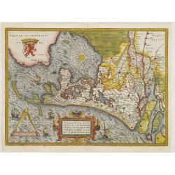
Hollandiae Antiquorum.
A mile stone map published by Ortelius on the basis of the map drawn by Jacob van Deventer in abt. 1550. Decorated with a large strapwork title cartouche, scale of miles ...
Date: Antwerp, 1584
Selling price: ????
Please login to see price!
Sold in 2015
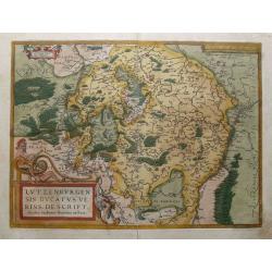
Lutzenburgensis Ducatus Veriss Descript.
Early map of the area of Luxembourg from Ortelius great "Theatrum Orbis Terrarum" the first modern atlas. Based on the 1551 manuscript map of Jacques Surhon. Th...
Date: Antwerp, 1584
Selling price: ????
Please login to see price!
Sold in 2015
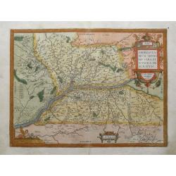
Anjou / Andegavensium Ditionis Vera et Integra Desciptio.
Very decorative map of a region in France, centered on the Loire River and Angiers. Highly detailed with hundreds of villages shown, forests, hills, etc. Includes several...
Date: Antwerp, 1584
Selling price: ????
Please login to see price!
Sold in 2015
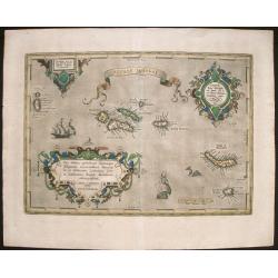
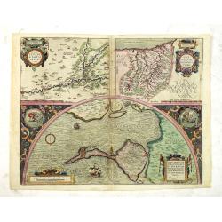
Açores Insulae. . .
Three cartouches of exceptional beauty decorate this artistic map. A beautifully engraved chart of the Azores based on Luis Teixeira's cartographic work with two ornate t...
Date: Antwerp, 1584
Selling price: ????
Please login to see price!
Sold in 2015
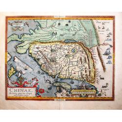
Chinae Olim Sinarum Regionis Nova Descriptio auctore Ludovico Georgio.
The first map of China which appeared in a western atlas. From a Latin edition of 1592 (latin text on verso, page 101, last line"moribus exilat...").This map, i...
Date: Antwerp, 1584
Selling price: ????
Please login to see price!
Sold in 2017
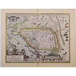
Chinae, olim Sinarum Regionis, nova descriptio. Auctore Ludovico Georgio.
A first state, the first issue of the first map of China to appear in a Western atlas [without "Las Philippinas"; Latin text to verso, the last line starts &quo...
Date: Antwerp, 1584
Selling price: ????
Please login to see price!
Sold in 2018
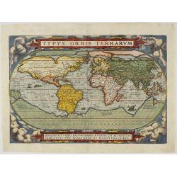
Typus Orbis Terrarum.
This important map of the world, first plate, appeared in the “Theatrum Orbis Terrarum” of Abraham Ortelius, the first regularly produced world atlas. Ortelius consul...
Date: Antwerp, 1584
Selling price: ????
Please login to see price!
Sold in 2018
The Best Ptolemaic Map of Germany: Europ. IIII. Tab.
An elegantly engraved map of Germany as it was known in the Roman Imperial Period from Mercator’s definitive edition of Ptolemy’s geography. It was based on geographi...
Date: Lyons, 1584
Selling price: ????
Please login to see price!
Sold in 2019
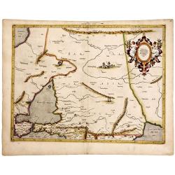
The Work of Two of History's Greatest Geographers. Morocco/ Algeria/ Tunisia/ Spain. Afr: I Tab:
A very attractive example of an early edition, the second, from Mercator’s definitive edition of Ptolemy’s geography. The map shows the area as it was known in the Ro...
Date: Cologne, 1584
Selling price: ????
Please login to see price!
Sold in 2019
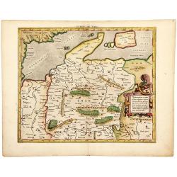
A Fine Example. Crimea/ Sea of Azov/ Russia. Asiae II Tab:
An early issue — the second — of this very attractive map of southern Russia from Mercator’s definitive edition of Ptolemy’s geography. Meeting in this map are tw...
Date: Cologne, 1584
Selling price: ????
Please login to see price!
Sold in 2019

Westphaliae Totius, Finitimarumque Regionum Accurata Descriptio.
A very beautiful hand color copper engraved map of North Rhein-Westphalia by A. Ortelius. From the 1584 Latin edition of the "Theatrum Orbis Terrarum". This is ...
Date: Antwerp, ca 1584
Selling price: ????
Please login to see price!
Sold in 2019
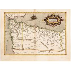
Africae Tabula Quarta. . .
The most general of the four Ptolemaic maps of Africa from Mercator’s definitive edition of Ptolemy’s geography. It extends far enough south to fully show Ptolemy’s...
Date: Cologne, ca 1584
Selling price: ????
Please login to see price!
Sold in 2019
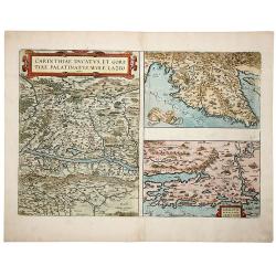
CARINTHIAE DUCATUS, ET GORITIAE PALATINATUS, WOLF. LAZIO -Histriae tabula a Petro Coppo defer - ZARAE, ET SEBENICI DESCRIPTION
A striking set of three maps on a single sheet, including the region around Villach on the Dravus River, the Gulf of Trieste and Quarnero and the region around Zara [Zada...
Date: Antwerp, 1584
Selling price: ????
Please login to see price!
Sold in 2019
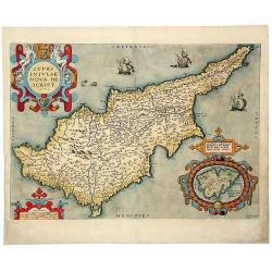
CYPRI INSULAE NOVA DE SCRIPT 1573 - LEMNOS INSULAE.
A striking, old colored example of this important early map of Cyprus from Ortelius' Theatrum Orbis Terrarum, the first modern atlas of the world. Large inset of Lemnos. ...
Date: Antwerp, 1584
Selling price: ????
Please login to see price!
Sold in 2019
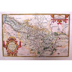
Picardiae Belgicae Regio Nis Descriptio
A highly detailed copper engraved map of the Picardie region in Northwest France by Abraham Ortelius. This map is finely engraved with forests, cities, villages along the...
Date: Antwerp, ca. 1585
Selling price: ????
Please login to see price!
Sold in 2015
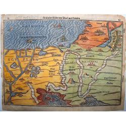
Reisen der Kinder Israel aus Egypten..
The map illustrates the travels of the Children of Israel out of Egypt. The path of the Israelites is delineated.It starts at the lower left in Egypt, crosses the Red Sea...
Date: Magdeburg, ca. 1585
Selling price: ????
Please login to see price!
Sold in 2016
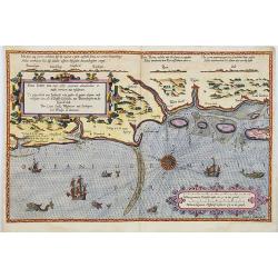
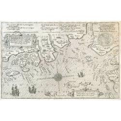
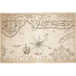
Zee Caerte vande Noordt custe van Engelandt, alsoe tzelffde landt aldaer. . .
A detailed description of the northern coast of England. Decorated by a title cartouche and scale cartouche, one compass rose, several vessels. A very early edition rare ...
Date: Leiden, Plantijn, 1585
Selling price: ????
Please login to see price!
Sold in 2016
Indiae Orientalis, Insularumque Adiacentium Typus
Map of Indonesia. From a French text edition of this illustrated treatise of geography, which is considered as the first modern pocket-atlas.Map engraved by Philip Galle....
Date: Antwerp, 1585
Selling price: ????
Please login to see price!
Sold in 2017

Roma.
This large, exceptionally decorative print depicts the city of Rome as it was around 1570. Still, the structures of Ancient Rome are still much in evidence.From the famou...
Date: Cologne, 1585
Selling price: ????
Please login to see price!
Sold in 2018
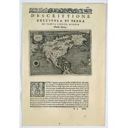
Descrittione dell' isola et terra di Santa Croce, overo Mondo Nuovo.
Porcacchi's map of North America, set in a page of text From "L'Isole piu famoso del mondo”. This is the second earliest obtainable map of North America, preceded ...
Date: Venice, 1572-1585
Selling price: ????
Please login to see price!
Sold in 2019
ARTESIA Comit.
Mercator's early map of the northern French region of Artois. Divisions in outline colors, strap-work title cartouche and mileage scale in the upper right, and lower left...
Date: Duisbourg, 1585
Selling price: ????
Please login to see price!
Sold in 2021
Chilonium, vulgo Kyell
A rare, large, spectacular view of the German city of Kiel. From the famous 'Civitates Orbis Terrarum' of Braun & Hogenberg, with spectacular original colors and with...
Date: Cologne, 1585
Selling price: ????
Please login to see price!
Sold in 2023
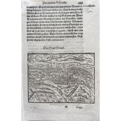
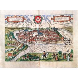
Praga
Nice early view of the city of Prag from the famous "Theatrum Urbium", appeared 1585. Just a few years after the appearance of the Civitates Orbis Terrarum, Abr...
Date: Frankfurt 1585
Selling price: ????
Please login to see price!
Sold in 2020
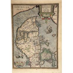
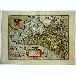
Cimbricae Chersonese nunc Iutiae descriptio.
A very decorative, old-colored example of Ortelius' map of Jutland, depicting also Fiona, Alsen, and Langeland. The map is based on the work of Marcus Jordanus, a profess...
Date: Antwerp, 1585
Selling price: ????
Please login to see price!
Sold in 2021
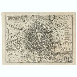
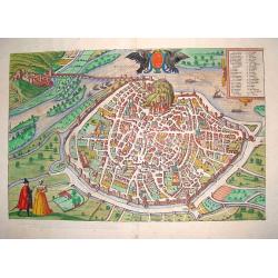
Gouda, elegantiss. Hollandiae Opp. ad Isalam amnem, ubi Goudam flu. à quo Oppidum nomen habet, absorbet. 1585.
A bird's-eye town-plan of Gouda. From the greatest publication in this genre!. The Civitates was compiled and written by George Braun, Canon of Cologne Cathedral. Braun g...
Date: Cologne, 1585
Selling price: ????
Please login to see price!
Sold in 2021
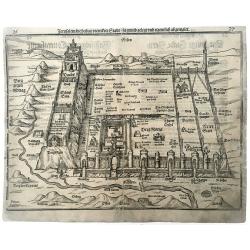
Jerusalem die heilige viereckete Stadt, in grund gelegt und eigentlich adgemalet.
The woodcut shows an imaginary plan of the Holy City of Jerusalem seen from the east. From the famous Bunting "Itinerarum Sacrae Scripturae".
Date: Magdeburg, 1585
Selling price: ????
Please login to see price!
Sold in 2021
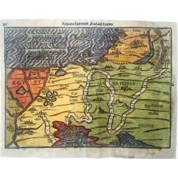
Reisen der Kinder von Israel aus Egypten
Very decorative example of Bünting's map of the Exodus of the Israelites from Egypt. This very detailed map shows the route of the Israelites in their Exodus from Egypt ...
Date: Magdeburg, 1585
Selling price: ????
Please login to see price!
Sold in 2021
![Insidijs circumuentum, puteo que profundo. . . Gene[sis] 37](/uploads/cache/47691-250x250.jpg)
Insidijs circumuentum, puteo que profundo. . . Gene[sis] 37
A superb example of this illustration from the series of the Story of Joseph. Joseph is taken out of the pit and sold by his brothers to a group of Ishmaelites. From ther...
Date: Antwerp, 1585
Selling price: ????
Please login to see price!
Sold in 2021
![Beniamin adducto repetunt cum munere Joseph, Quos fratres tendem prodidit esse suos. Gene[sis] 43](/uploads/cache/47692-250x250.jpg)
Beniamin adducto repetunt cum munere Joseph, Quos fratres tendem prodidit esse suos. Gene[sis] 43
A superb example of this illustration from the series of the Story of Joseph. Joseph receives his brothers and Benjamin.Copper engraving published in " Thesaurus sac...
Date: Antwerp, 1585
Selling price: ????
Please login to see price!
Sold in 2021

Mercurius.
Mercury holding a caduceus and riding in a chariot drawn by two birds on the clouds in the sky, an extensive landscape with a harbor with goods being loaded and unloaded ...
Date: Antwerp, 1585
Selling price: ????
Please login to see price!
Sold in 2025
Gallipolis..
Very decorative view of Gallipolis from the greatest publication in this genre!. The "Civitates". Compiled and written by George Braun, Canon of Cologne Cathedr...
Date: Cologne 1585
Selling price: ????
Please login to see price!
Sold
Avignon.
A fine bird?s eye view of the ancient capital of Provence, Avignon, from the famous CIVITATES ORBIS TERRARUM. The work contains a 45 point legend, identifying key sights....
Date: Cologne, 1585
Selling price: ????
Please login to see price!
Sold

Portrait of a virgin (Agnes ?)
Etching by Herman Muller, of a seated woman with a palm leaf in her hand as sign of martyrdom, a lamb and part of an anchor in the foreground, probably St.Agnes.Engraved ...
Date: The Netherlands ca. 1585
Selling price: ????
Please login to see price!
Sold
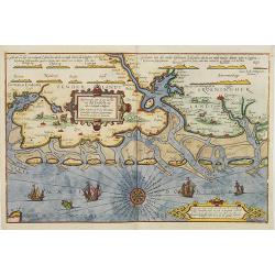
De Zee Custen tuschen Dovere eñ Orfordts nesse, daer de Teemse de Vermaerde Riviere vã Lõnen gelegens is, met alle sanden ondiepte, naer haren wesen eñ ghedaente / Orae maritimae inter Doverium et Ortfortnissam &tc.
Lucas Janszoon Waghenaer (1533/4-1606) published in 1583 his famous pilot-guide ' Spieghel der Zeevaerdt', the first printed pilot-guide with charts, in 1592 he published...
Date: Leiden, 1585
Selling price: ????
Please login to see price!
Sold in 2008
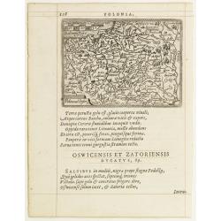
Poloniae Descrip.
Map of Poland from the first Latin edition and the only not issued in an oblong format of this illustrated treatise of geography, which is considered as the first modern ...
Date: Antwerp, 1585
Selling price: ????
Please login to see price!
Sold in 2009
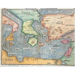
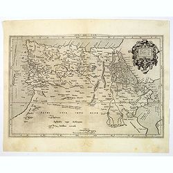
Tafel Der Lender Darin Der Apostel Paulus Geprediget Hat.
The Eastern Mediterranean, from the "Itinerarium Sacrae Scripturae", showing Italy, Sicily, Greece, Cyprus, Asia Minor, the Holy Land and North Africa, with cit...
Date: Magdeburg, 1585
Selling price: ????
Please login to see price!
Sold in 2014
Beschrijvinge vande vermaerde stroemen, Tvlie ende Tmaersdiep: opstreckende Inde Zijder Zee voerby Enchuijsen tot Amsterdam. . .
A detailed chart of the coast of Holland decorated by several cartouches with several colorful cartouches, scale cartouches, compass roses, 5 vessels and 2 sea monster. F...
Date: Leiden, Plantijn, 1585
Selling price: ????
Please login to see price!
Sold in 2009
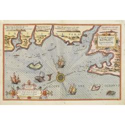
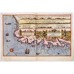
Chartae orarum . . . . Caerte vanden zee Custen, eensdeels Normandien, en Brittangen. . .
A detailed chart of the Normandy coast and the channel islands of Jersey, Guernsey, Alderney and Sarck decorated by a colorful title cartouche and scale cartouche, two co...
Date: Leiden, Plantijn, 1585
Selling price: ????
Please login to see price!
Sold in 2008
De zee Custe, met de England van Bretaignen, tusschenn Blauet en Picqueliers. . .
DUTCH TEXT EDITION. A detailed chart of the coast of southern part of Brittany, covering the coast from Vannes till Hilaire-de-Riez. Decorated by a colorful title cartouc...
Date: Leiden, Plantijn, 1585
Selling price: ????
Please login to see price!
Sold in 2009
Verthoninghe van zee Cuften van Bretaignen. . .
DUTCH TEXT EDITION. A detailed chart of the coast of Brittany decorated by a very colorful title cartouche and scale cartouche, one compass rose, several vessels and sea ...
Date: Leiden, Plantijn, 1585
Selling price: ????
Please login to see price!
Sold
Zee caerte van Engelants Eijndt, Alsoe hem tselfde Landt verthoont beginnende van Sorlinges tot Pleijmondt . . .
A detailed chart of the sea coast of England, from the Sorlinges islands to the Plymouth region along the English Channel decorated by a very colorful title cartouche and...
Date: Leiden, Plantijn, 1585
Selling price: ????
Please login to see price!
Sold in 2009
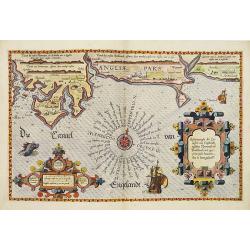
Befchrijvinghe der Zee, custen van Engelandt, tusschen Pleijmouth en Porthlandt. . .
A detailed chart of the sea coast of England, from Plymouth region along the English Channel to Portland decorated by a very colorful title cartouche and scale cartouche,...
Date: Leiden, Plantijn, 1585
Selling price: ????
Please login to see price!
Sold in 2009
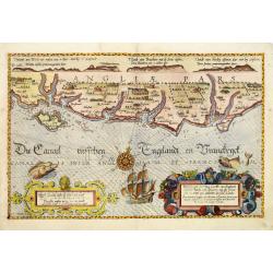
Befchrijvinghe der Zeecusten van Engelandt tusschen Wicht ende Doveren. . .
A detailed chart of the English channel coastland, from the island of Wight to Dover. Decorated by a very colorful title cartouche and scale cartouche, one compass rose, ...
Date: Leiden, Plantijn, 1585
Selling price: ????
Please login to see price!
Sold in 2008
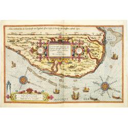
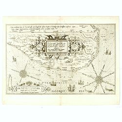
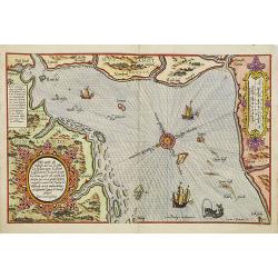
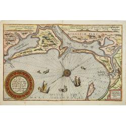
Zee Caerte vande Noordt custe van Engelandt, alsoe tzelffde landt aldaer. . .
A detailed chart of the northern coast of England. Decorated by a colorful title cartouche and scale cartouche, one compass rose, several vessels. A very early edition ra...
Date: Leiden, Plantijn, 1585
Selling price: ????
Please login to see price!
Sold in 2008
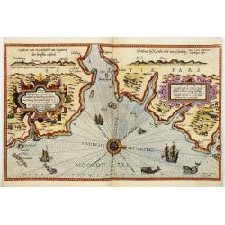
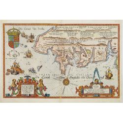
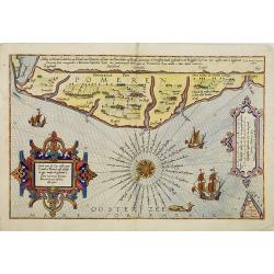
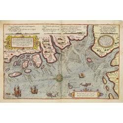
Beschrijvinge van een deel vann Schottlandt van Bambourg tot Aberdein. . .
A detailed chart of the coast of Scotland with Aberdeen. Decorated by a colorful title cartouche and scale cartouche, one compass rose, several vessels and sea monsters. ...
Date: Leiden, Plantijn, 1585
Selling price: ????
Please login to see price!
Sold in 2008
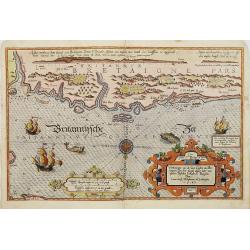
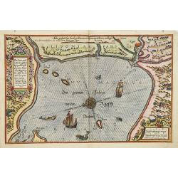
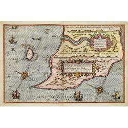
Die zee custe van Noorweghen tusschen der Noess en Mardou. . .
A rare Dutch text edition of this early and detailed chart of the coast of Norway. Decorated by a colorful title cartouche and scale cartouche, one compass rose, several ...
Date: Leiden, Plantijn, 1585
Selling price: ????
Please login to see price!
Sold in 2024
Zhet noterfte ofte Oosterste deel van de Oster Zee, beslooten tegens Rus landt.Lijfflandt, Oost Finlandt . . .
A detailed chart of the coast of Finland. Decorated by a title, scale and descriptive cartouche, a compass rose, several vessels and sea monsters, and depictions of mount...
Date: Leiden, Plantijn, 1585
Selling price: ????
Please login to see price!
Sold in 2008
Zee caerte vande cufte va Lijfflandt begrepen Ronsomede grooten Inham. . .
A detailed chart of the Gulf of Riga and the Lithuanian coast. Decorated by a title and scale cartouche, a compass rose, several vessels and sea monsters, and depictions ...
Date: Leiden, Plantijn, 1585
Selling price: ????
Please login to see price!
Sold in 2008
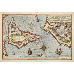
De Zee kuste Rontomme Oesel eb een deel van Curlandt beginnende va Dagher oort tot Der winde . . .
A detailed chart of the entrance of the Gulf of Riga, with the island of Saaremaa. Decorated by a title, scale and descriptive cartouche, a compass rose, several vessels ...
Date: Leiden, Plantijn, 1585
Selling price: ????
Please login to see price!
Sold in 2013
De caerte ofte zee cuften van Pruijssen, met zijne haffen ofte groote Rivieren. . .
A detailed chart of part of the coastline of Poland and the city of Danzig (Gdansk). Decorated by a title, scale and descriptive cartouche, a compass rose, several vessel...
Date: Leiden, Plantijn, 1585
Selling price: ????
Please login to see price!
Sold
Caerte van de zee custe vant Landt te Pomere. . .
A detailed chart of part of the coastline of Poland and the city of Pomeren, and part of the Danish island of Bornholm. Decorated by a title and scale cartouche, a compas...
Date: Leiden, Plantijn, 1585
Selling price: ????
Please login to see price!
Sold
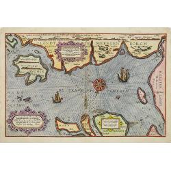
Caerte vande zee custe va Mekelenborch, Soe de Landen. . . Tot Femeren. . .
A rare Dutch text edition of this early detailed chart with the island of Rügen to the feft, the coastline of Mecklenburgh and Fehmarnbelt with the island of Fehmarn. No...
Date: Leiden, Plantijn, 1585
Selling price: ????
Please login to see price!
Sold in 2017
Beschrivingee der zijden op de Belt en Noortzee. . .
A rare Dutch text edition of this early detailed chart of the coast of Jutland and its towns Skagen among others. Decorated by a title and scale cartouche, two compass ro...
Date: Leiden, Plantijn, 1585
Selling price: ????
Please login to see price!
Sold in 2022
Descriptio ditionum littoralium maris Germanici, videlicet, Eijderstadij, Dithmarsiae. . .
A detailed chart of the Dithmarschen region in the North coastline of Germany. Decorated by a title, scale and a descriptive cartouche, one compass rose, several vessels ...
Date: Leiden, Plantijn, 1585
Selling price: ????
Please login to see price!
Sold in 2008
Beschrijvinghe van de zee custen van Ooft Vriesslandt. . .
A detailed chart of the Groeninger region situated at the southern tip of the Jutland Peninsula. Decorated by a title, scale and a descriptive cartouche, one compass rose...
Date: Leiden, Plantijn, 1585
Selling price: ????
Please login to see price!
Sold in 2013
De gelegentheijt van Jutlandt, mits gaders de gaeten . . Tot dat Eijlandt Silt.
A detailed chart of the Danish coastline, including Tondern and te island Silt. Decorated by a title, scale and a descriptive cartouche, one compass rose, several vessels...
Date: Leiden, Plantijn, 1585
Selling price: ????
Please login to see price!
Sold in 2022
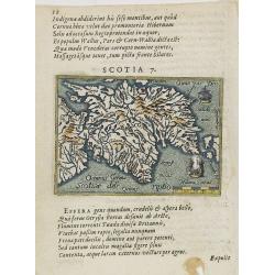
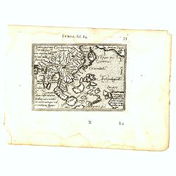
Scotia 7.
A page of printed text in Latin with a fine general map of Scotland. Prepared by Hugo Favolius (1523-1585), who was a Dutch poet, doctor and traveler, born in Middelburg....
Date: Antwerp, Plantin, 1585
Selling price: ????
Please login to see price!
Sold in 2009
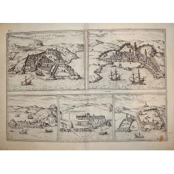
Tingis, Lusitanis, Tangiara
A handsome five section map offering town-views of historically significant Portuguese empire North African coastal towns and entrepots, including Tangiers, Tzaffin, Ceut...
Date: Cologne, ca. 1585
Selling price: ????
Please login to see price!
Sold in 2011
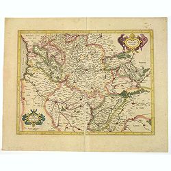
Brabantia, Gulick et Cleve.
The full coloring of the different areas with the borderlines in the same color, only slightly darker, is typical of the 16th century.
Date: Duisburg, 1585
Selling price: ????
Please login to see price!
Sold in 2017
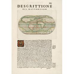
Descrittione del Mappa Mondo.
This miniature world map is a finely-executed reduction of Carmocio's large Gastaldi's prototype of 1546. However here in the rare 1586 edition of the L'Isole by Pietr' A...
Date: Venice, 1586
Selling price: ????
Please login to see price!
Sold in 2014
Beschrijvinghe der Zee Custen van Eiderste, Dithmers, en ee deel vant Fromges landt, ...
Sea chart by Waghenaer. Latin text on verso.
Date: Leiden, 1586
Selling price: ????
Please login to see price!
Sold in 2009
De Custen van een deel van Denemarken en Swederyck , beginnede va Uuytlte tot Calmer toe. . .
A decorative uncloured chart displaying the North Sea and the coast of Sweden and Denmark. Several vignettes of sea monsters and a ship. It was published by Dutch cartogr...
Date: Leiden, 1586
Selling price: ????
Please login to see price!
Sold in 2009
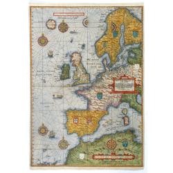
Universe Europe Maritime Eiusque Navigationis Descritio. Generale Pas chaerte van Europa. . . 1583.
The rare first plate of Waghenaer's general sea chart of Europe, dated 1583, with Latin text on verso; from the first Latin text edition, published in Leiden: Frans van R...
Date: Enkhuizen, 1586
Selling price: ????
Please login to see price!
Sold in 2017
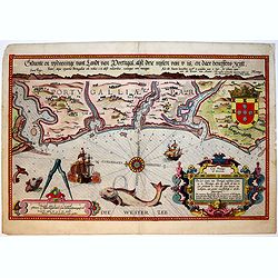
Die Zee Caerte van Portugal, tusschen Camino en Montego, alsoe dat Landt all daer in sijn Ghedaente is, met alle sijne haeven enn ondiepten ...
A fine and very rare maritime map with detailed description of part of Portugal. Decorated by a colorful title cartouche and scale cartouche, one compass rose, several ve...
Date: Leiden, Plantijn, 1584-1586
Selling price: ????
Please login to see price!
Sold in 2019
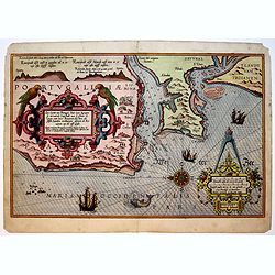
Zee Caerte van Portugal, Daer inne Begrepen de vermaerde Coopstadt van Lisbone ..
A very rare and exquisite maritime map of a part of Portugal including Lisbon. Decorated by a colorful title cartouche and scale cartouche, one compass rose, several vess...
Date: Leiden, Plantijn, 1584-1586
Selling price: ????
Please login to see price!
Sold in 2019
Zee Custen van Andaluzien ghemaeckt naet wesen en ghedaente, met zijn Rivieren en Hauenen.
A very rare and fine maritime map detailed of the eastern part of Andalusia. Decorated by a colorful title cartouche and scale cartouche, one compass rose, several vessel...
Date: Leiden, Plantijn, 1584-1586
Selling price: ????
Please login to see price!
Sold in 2019
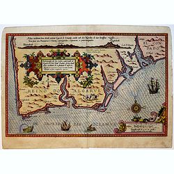
Beschrijvinghe der Zee Custen vant Landt va Argarbe ..
A fine and rare historical maritime map of southern Portugal (Reino do Algarve). Decorated by a colorful title cartouche and scale cartouche, one compass rose, several ve...
Date: Leiden, Plantijn, 1584-1586
Selling price: ????
Please login to see price!
Sold in 2019