Browse Listings
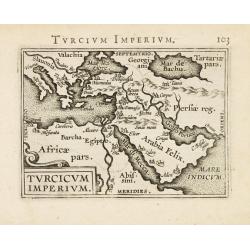
Turcicum Imperium.
Miniature map of Turkish Empire. From the second series of miniature atlas of Ortelius' Epitome. A new series of pocket-size atlases was begun by Philip Galle in 1588. It...
Date: Antwerp 1589
Selling price: ????
Please login to see price!
Sold
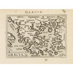
Graecia.
Miniature map of Greece. From the second series of miniature atlas of Ortelius' Epitome. A new series of pocket-size atlases was begun by Philip Galle in 1588. It seems t...
Date: Antwerp 1589
Selling price: ????
Please login to see price!
Sold
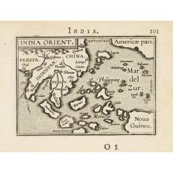
India Orient.
Miniature map of the Far East with Indonesia, Japan, Pacific and New Guinea. From the second series of miniature atlas of Ortelius' Epitome. A new series of pocket-size a...
Date: Antwerp 1589
Selling price: ????
Please login to see price!
Sold
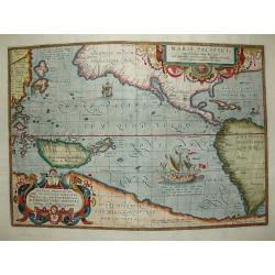
Maris Pacifici.
The first printed map of the Pacific. Acknowledged to be one of the most beautiful and decorative maps which appeared in the Theatrum Orbis Terrarum, it was also one of t...
Date: Antwerp 1589
Selling price: ????
Please login to see price!
Sold
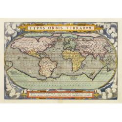
Typus Orbis Terrarum.
Fine example of the extremely rare second state world map, issued in the first regularly produced world atlas. The map is a careful reduction of Mercator's landmark wall-...
Date: Antwerp 1589
Selling price: ????
Please login to see price!
Sold
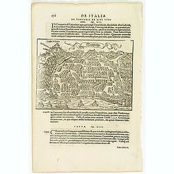
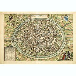
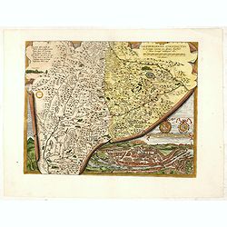
Brescia Episcopanus Mediolanu Ducatus.
Brescia by Mercator, first edition !
Date: Amsterdam, 1589
Selling price: ????
Please login to see price!
Sold in 2010
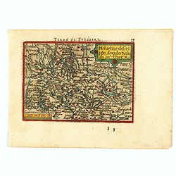
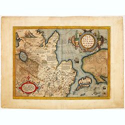
Helvetiae Descriptio, Aegidio Tschudo Auctore
This is the rare pocket edition of Abraham Ortelius maps, prepared and engraved by Philippe Galle in Antwerp in 1589. It depicts Switzerland, and. it has a neat title and...
Date: Antwerp, 1589
Selling price: ????
Please login to see price!
Sold in 2021
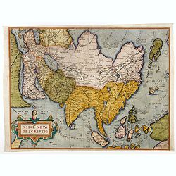
Asiae Nova Descriptio.
Second state. Ortelius' fine map of Asia well represents the continent at a time when Europeans were expanding their power in the far east. The Indian subcontinent and Ma...
Date: Antwerp, 1580/1589
Selling price: ????
Please login to see price!
Sold in 2020
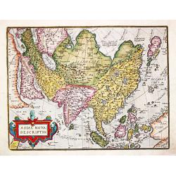
Asiae Nova Descriptio.
Second state. Ortelius' fine map of Asia well represents the continent at a time when Europeans were expanding their power in the far east. The Indian subcontinent and Ma...
Date: Antwerp, 1580/1589
Selling price: ????
Please login to see price!
Sold in 2018
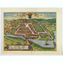
Colding Schloss und Stat.
A bird's eye view of Kolding castle and town from Braun & Hogenberg. The port of Kolding on the Danish Jutland Peninsula is seen in cavalier perspective from the sout...
Date: Cologne, 1589
Selling price: ????
Please login to see price!
Sold in 2019
![Cairus, quae olim Babylon, . . . [Cairo]](/uploads/cache/60659-250x250.jpg)
Cairus, quae olim Babylon, . . . [Cairo]
Contemporaneous bird's-eye and surroundings showing the Pyramids and the Sphinx. Egypt had fallen to the Turks during the reign of Selim I at the beginning of the 16th c...
Date: Cologne, 1590
Selling price: ????
Please login to see price!
Sold
Americae pars, Nunc Virginia dicta, primum ab Anglis. . .
John White's map, elegantly designed and superbly engraved, revolutionized geographic knowledge of the region. Although White left the Chesapeake poorly explored, much of...
Date: Frankfurt, 1590
Selling price: ????
Please login to see price!
Sold
![Von dem Hertogthumb Braband. . . [Brabant]](/uploads/cache/32239-250x250.jpg)
Von dem Hertogthumb Braband. . . [Brabant]
On recto an early birds-eye view of Luik in Belgium.From a German text edition of his Geographia , that great compendium of Renaissance knowledge.
Date: Basle, 1550-1590
Selling price: ????
Please login to see price!
Sold in 2012
![Contrastung der Statt Löven. . . [Leuven]](/uploads/cache/32240-250x250.jpg)
Contrastung der Statt Löven. . . [Leuven]
On verso an early birds-eye view of Leuven and on recto a plan of Tongeren in Belgium, with a lettered key underneath.From a German text edition of his Geographia , that ...
Date: Basle, 1550-1590
Selling price: ????
Please login to see price!
Sold in 2012
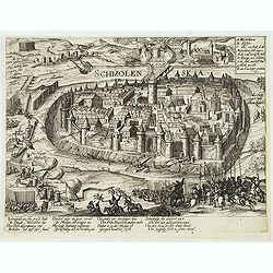
Smolensk.
View of the siege of Smolensk. "Schmolenska" by the Polish army in1609-1611. The Dnieper River in the background. From Hogenberg's "Geschichtsblättern&quo...
Date: Cologne,1590
Selling price: ????
Please login to see price!
Sold in 2012
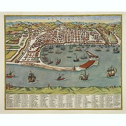
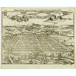
Messina.
A of the city of Messina on Sicily by Matteo Florimi (1540-1613). Below the view is a numbered key (1-167) with a key to locations.Florimi was a print-and-book dealer an...
Date: Sienna, c. 1590
Selling price: ????
Please login to see price!
Sold in 2014
Neapolis.
On recto an early birds-eye view of Naples. On verso a city view of Tivoli. From a Latin text edition of his Geographia , that great compendium of Renaissance knowledge.S...
Date: Basle, 1550-1590
Selling price: ????
Please login to see price!
Sold in 2012
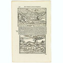
Cyprus.
Two woodcuts on one page. In upper part a map of Cyprus, in lower part a jumping deer and a sheep drinking water. The drinking sheep with old pen scratches. . From a Lati...
Date: Basle, 1550-1590
Selling price: ????
Please login to see price!
Sold in 2012
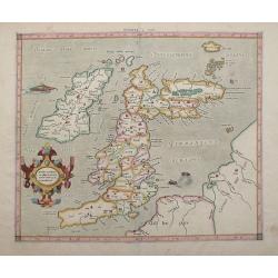
Tab. I. Europae Continens Albion, Britanniam, et Hiberniam.
Mercator’s map of Great Britain, based on Ptolemy’s Geographia. This map is from the 1584 edition of his Tabulae Geographicae. The ancient map of the British Isles ha...
Date: Cologne, Amsterdam, 1590
Selling price: ????
Please login to see price!
Sold in 2012
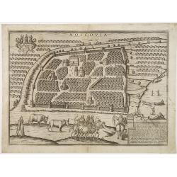
Moscovia. Questa Citta è la principale de la provincia di Russia. . .
Very rare Lafreri school-type plan of Moscow from a slightly elevated viewpoint across the frozen Moskva River. The print is based on a view by the Austrian Sebastian Her...
Date: Siena, 1590
Selling price: ????
Please login to see price!
Sold in 2012
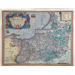
Prussiae vera descriptio.
Map of Poland, oriented to the North. Prepared by the cartographer Caspar Henneberger. From "Theatrum Orbis Terrarum Abrahami Ortelii Antverp".
Date: Antwerpen, 1590
Selling price: ????
Please login to see price!
Sold in 2015
Principale della provincia citta del peru il cuscho.
On recto an early birds-eye view of Cusco. On verso tittle page and a plan of Mexico City "Urbs themistiana hispaniae" (165x162mm.)From a German text edition of...
Date: Basle, 1550-1590
Selling price: ????
Please login to see price!
Sold in 2014
![[Europe]](/uploads/cache/32516-250x250.jpg)
[Europe]
On verso an early wood block printed map of Europe.From a Latin text edition of his Geographia , that great compendium of Renaissance knowledge.
Date: Basle, 1550-1590
Selling price: ????
Please login to see price!
Sold in 2013
![[British Isles ]](/uploads/cache/32517-250x250.jpg)
[British Isles ]
On recto an early birds-eye view of Great Britain. Cornwall is depicted as an entity on an equal footing as Wales and Scotland.From a Latin text edition of his Geographia...
Date: Basle, 1550-1590
Selling price: ????
Please login to see price!
Sold in 2013
![[ Spain and Portugal ]](/uploads/cache/32527-250x250.jpg)
[ Spain and Portugal ]
On recto an early wood block printed map of Spain and Portugal.From a Latin text edition of his Geographia , that great compendium of Renaissance knowledge.
Date: Basle, 1550-1590
Selling price: ????
Please login to see price!
Sold in 2013
![[ Italy ]](/uploads/cache/32528-250x250.jpg)
[ Italy ]
On recto a wood block printed map of the center part of Italy (159x129mm.), south orientated to the top. Corsica in upper right corner.From a Latin text edition of his Ge...
Date: Basle, 1550-1590
Selling price: ????
Please login to see price!
Sold in 2013
![Nova Africa hoc est,recens eius inuestigatio. [North Africa]](/uploads/cache/32529-250x250.jpg)
Nova Africa hoc est,recens eius inuestigatio. [North Africa]
On verso an early map of North West Africa (123x155mm.), with on recto a small map of the island of Madeira (120x78mm.) From a Latin text edition of his Geographia , that...
Date: Basle, 1550-1590
Selling price: ????
Please login to see price!
Sold in 2013
![[Flandria - Belgium]](/uploads/cache/32530-250x250.jpg)
[Flandria - Belgium]
On recto an early wood block printed map (115x153mm.) of Flanders in present-day Belgium. On verso a tiny view of Gent.From a Latin text edition of his Geographia, that g...
Date: Basle, 1550-1590
Selling price: ????
Please login to see price!
Sold in 2013
![[De istria Peninsula.]](/uploads/cache/32532-250x250.jpg)
[De istria Peninsula.]
On verso a wood block printed map of the triangular peninsula of Istria pointing down into the northern Adriatic. From a Latin text edition of his Geographia, that great ...
Date: Basle, 1550-1590
Selling price: ????
Please login to see price!
Sold in 2013
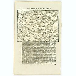
De terris asiae minoris.
On verso a wood block printed map of Turkey (139x183). From a Latin text edition of his Geographia , that great compendium of Renaissance knowledge.
Date: Basle, 1550-1590
Selling price: ????
Please login to see price!
Sold in 2013
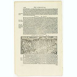
![[De Graecia.- Euböa or Evia ]](/uploads/cache/32552-250x250.jpg)
[De Graecia.- Euböa or Evia ]
On verso an early wood block printed map of the island of Euböa (Evia) in Greece. Below a portrait of Aristote. From a Latin text edition of his Geographia , that great ...
Date: Basle, 1550-1590
Selling price: ????
Please login to see price!
Sold in 2017
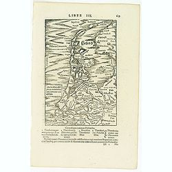
Candia seu Creta insula.
On recto an early map of the Island of Crete (77x156mm.). From a Latin text edition of his Geographia , that great compendium of Renaissance knowledge.Read more [+]
Date: Basle, 1550-1590
Selling price: ????
Please login to see price!
Sold in 2020
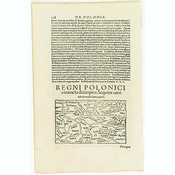
Regni polonici contracta descriptio. sequens uero. . .
On verso a map of Poland (77x156mm.) From a Latin text edition of his Geographia , that great compendium of Renaissance knowledge.
Date: Basle, 1550-1590
Selling price: ????
Please login to see price!
Sold in 2013
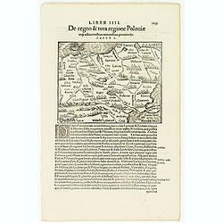
De regno & tota regione Poloniae. . .
On recto an early map of Poland (120x153mm.), extending from the Baltic (Danzig and Riga) to Moscow, Cremania, and Moldau in the east and the Oder and Klein Poland in the...
Date: Basle, 1550-1590
Selling price: ????
Please login to see price!
Sold in 2013
Holland. . .
On recto a map of the provinces of North and South Holland in the Netherlands. />From a Latin text edition of his Geographia , that great compendium of Renaissance kno...
Date: Basle, 1550-1590
Selling price: ????
Please login to see price!
Sold in 2013
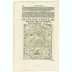
Siciliae insulae atque totius regni eius descriptio, secundum uarium eius habitudinem.
On verso an early map of Sicily. From a Latin text edition of his Geographia , that great compendium of Renaissance knowledge.
Date: Basle, 1550-1590
Selling price: ????
Please login to see price!
Sold in 2013
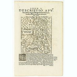
Regnum Neapolit. Mare mediterraneum.
On recto a map of Southern part of Italy. />From a Latin text edition of his Geographia , that great compendium of Renaissance knowledge.
Date: Basle, 1550-1590
Selling price: ????
Please login to see price!
Sold in 2013
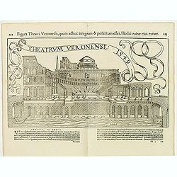
Theatrum Veronense. . .
A double page illustration of the Roman Theatre of Verona, constructed in the 1st century B.C., at the foot of the Hill of St. Peter on the banks of the Adige River. />...
Date: Basle, 1550-1590
Selling price: ????
Please login to see price!
Sold in 2013
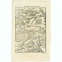
De terris asiae minoris.
On verso a wood block printed map of the region between the Black Sea and the Caspian Sea with parts of Tartary and Kazakhstan, also the neighboring Armenia in the south....
Date: Basle, 1550-1590
Selling price: ????
Please login to see price!
Sold in 2013
![Descriptio Italiae secundum uarios populos. . . [Italy]](/uploads/cache/32573-250x250.jpg)
Descriptio Italiae secundum uarios populos. . . [Italy]
On verso a wood block printed map of Italy.From a Latin text edition of his Geographia , that great compendium of Renaissance knowledge.
Date: Basle, 1550-1590
Selling price: ????
Please login to see price!
Sold in 2013
![[Amsterdam]](/uploads/cache/32574-250x250.jpg)
[Amsterdam]
On verso an early birds-eye town-plan of Amsterdam. The wood block print is showing hundreds of individual buildings and houses. Ships in the harbor and the Amstel River....
Date: Basle, 1550-1590
Selling price: ????
Please login to see price!
Sold in 2013
![In monte casio iuxta ostracinam. . . [Israel with Cyprus]](/uploads/cache/32575-250x250.jpg)
In monte casio iuxta ostracinam. . . [Israel with Cyprus]
On recto a woodcut engraved map of Israel and Cyprus. Engraved by Hans Rudolf Manuel Deutsch, with his monogram. From a Latin text edition of his Geographia , that great ...
Date: Basle, 1550-1590
Selling price: ????
Please login to see price!
Sold in 2015
![Nova India, ut nostro tempore est explorata & cognita. [India]](/uploads/cache/32576-250x250.jpg)
Nova India, ut nostro tempore est explorata & cognita. [India]
On recto a wood block engraved map of India.From a Latin text edition of his Geographia , that great compendium of Renaissance knowledge.
Date: Basle, 1550-1590
Selling price: ????
Please login to see price!
Sold in 2013
![[Java Maior ]](/uploads/cache/32577-250x250.jpg)
[Java Maior ]
On recto a wood block printed map of Java (125x76mm.) with a short description of the island, underneath description of Madagascar , Zanzibar and "Duabus Insulis&quo...
Date: Basle, 1550-1590
Selling price: ????
Please login to see price!
Sold in 2013
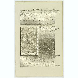
Sumatra Insula - Taproba.
On recto a wood block printed map of Sumatra within text bearing the name "Taprobana". The island is filled with many images like an elephant and a tiger, as we...
Date: Basle, 1550-1590
Selling price: ????
Please login to see price!
Sold in 2013
![[Cuba]](/uploads/cache/32579-250x250.jpg)
[Cuba]
On recto a wood block printed map of Cuba (79x123mm.).From a Latin text edition of his Geographia , that great compendium of Renaissance knowledge.
Date: Basle, 1550-1590
Selling price: ????
Please login to see price!
Sold in 2013
![[Afrique]](/uploads/cache/32581-250x250.jpg)
[Afrique]
On recto a strongly engraved woodblock map of the continent depicts the Nile's origins in twin lakes originating in the Motes Lunae, or Mountains of the Moon, based on Pt...
Date: Basle, 1550-1590
Selling price: ????
Please login to see price!
Sold in 2013
![De Cyrene seu Cyrenaica. [Egypt and Ethiopia]](/uploads/cache/32582-250x250.jpg)
De Cyrene seu Cyrenaica. [Egypt and Ethiopia]
On recto an early wood block printed map of Egypt and Ethiopia and the Arabian Peninsular tio the right. (160xFrom a Latin text edition of his Geographia, that great comp...
Date: Basle, 1550-1590
Selling price: ????
Please login to see price!
Sold in 2014
![[Egypte]](/uploads/cache/32584-250x250.jpg)
[Egypte]
On recto an early wood block printed map of Northern Egypt (176x160mm.) .From a Latin text edition of his Geographia , that great compendium of Renaissance knowledge.
Date: Basle, 1550-1590
Selling price: ????
Please login to see price!
Sold in 2013
![India extra Gangem, quae Europeis propinquior est. [India]](/uploads/cache/32585-250x250.jpg)
India extra Gangem, quae Europeis propinquior est. [India]
On recto an wood block printed Ptolemaic map of South East Asia, India and China (122x153mm.)From a German text edition of his Geographia , that great compendium of Renai...
Date: Basle, 1550-1590
Selling price: ????
Please login to see price!
Sold in 2013
![[Panther]](/uploads/cache/32586-250x250.jpg)
[Panther]
On verso an early wood block printed depicting of a panther. Engraved by Rudolf Manuel Deutsch (1525 - 1571) with his monogram.Hans Rudolf Manuel Deutsch was a painter, d...
Date: Basle, 1550-1590
Selling price: ????
Please login to see price!
Sold in 2013
![[Ship Victoria of Ferdinand Magellan]](/uploads/cache/32588-250x250.jpg)
[Ship Victoria of Ferdinand Magellan]
On recto a description of the expedition of Ferdinand Magellan with a wood block printed depiction of his ship "Victoria" (69x65mm.)From a Latin text edition of...
Date: Basle, 1550-1590
Selling price: ????
Please login to see price!
Sold in 2013
![Pyramides Aegypti. [Pyramides in Egypt]](/uploads/cache/32590-250x250.jpg)
Pyramides Aegypti. [Pyramides in Egypt]
On verso a wood block printed depiction of three pyramids in Egypt.From a Latin text edition of his Geographia , that great compendium of Renaissance knowledge.
Date: Basle, 1550-1590
Selling price: ????
Please login to see price!
Sold in 2013
![[Ptolemée]](/uploads/cache/32591-250x250.jpg)
[Ptolemée]
On verso a wood block print showing Ptolemy sitting at a table surrounded with surveying instruments and an atlas. (53x75mm.) From a Latin text edition of his Geographia ...
Date: Basle, 1550-1590
Selling price: ????
Please login to see price!
Sold in 2013
![Stoliditas struthionis [Ostrich]](/uploads/cache/32592-250x250.jpg)
Stoliditas struthionis [Ostrich]
On verso an early depiction of a ostrich .From a German text edition of his Geographia , that great compendium of Renaissance knowledge.Read more [+]
Date: Basle, 1550-1590
Selling price: ????
Please login to see price!
Sold in 2014
![[De Africae regionibus / Carthage]](/uploads/cache/32593-250x250.jpg)
[De Africae regionibus / Carthage]
On the verso an early birds-eye view of Tunis, which was the original city of Carthage (240x168mm.). The plan includes zoological and botanical gardens, castle Goleta, a ...
Date: Basle, 1550-1590
Selling price: ????
Please login to see price!
Sold in 2013
![[De Africae regionibus ] Algier.](/uploads/cache/32594-250x250.jpg)
[De Africae regionibus ] Algier.
On verso an early birds-eye town-plan of Alger.From a Latin text edition of his Geographia , that great compendium of Renaissance knowledge.
Date: Basle, 1550-1590
Selling price: ????
Please login to see price!
Sold in 2013
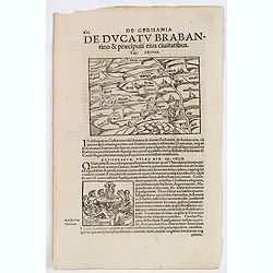
De Germania de Ducatu Brabantino. . . (Brabant)
On recto a map of the province of Brabant covering present-day the Netherlands and Belgium. From a Latin text edition of his Geographia , that great compendium of Renaiss...
Date: Basle, 1550-1590
Selling price: ????
Please login to see price!
Sold in 2013
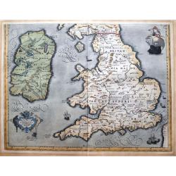
Brittanicarum Insularum Vetus Descriptio.
Southern part of Ortelius important two-sheet map of the British Isles. Includes Ireland, Wales, the Isle of Man, and England. Shows the Hadrian's Wall. Richly decorated ...
Date: Antwerp, c1590
Selling price: ????
Please login to see price!
Sold in 2013
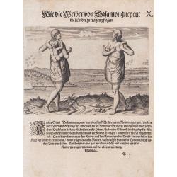
Wie die Weiber von Dafamonguepeuc.
Engraving depicting a native American woman of Dasamonguepeuc carrying a child, from Theodorus De Bry's Les Grands Voyages.
Date: Frankfurt, 1590
Selling price: ????
Please login to see price!
Sold in 2013
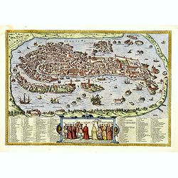
Venetia. (Venice)
Precise, beautiful bird's-eye town-plan of Venice, clearly depicting the city's architectural landmark. The surrounding lagoon is animated with a great variety of sailing...
Date: Cologne, 1590
Selling price: ????
Please login to see price!
Sold in 2013
Tartariae sive Magni Chami Imperium.
This is a very early depiction of the northern Pacific, with the first mapping of Northwest Coast of America and probably the first map to name California 'C. Califormio'...
Date: Antwerp, c. 1590
Selling price: ????
Please login to see price!
Sold in 2014
Brugae, Flandricarum Urbium Ornamenta. (Brugge)
Very desirable and early town-plan of Brugge. "from a northwesterly direction, ringed by numerous windmills. At the center can be seen the market square with the clo...
Date: Cologne, 1590
Selling price: ????
Please login to see price!
Sold in 2014
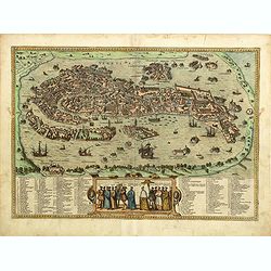
Venetia. (Venice)
Precise, beautiful bird's-eye town plan of Venice, clearly depicting the city's architectural landmark. The surrounding lagoon is animated with a great variety of sailing...
Date: Cologne, 1590
Selling price: ????
Please login to see price!
Sold in 2014

Theatre des principales villes tout l'univers. Second volume. (Title page)
The most decorative frontispiece of the 2nd part of the "Civitatus Orbis Terrarum" The title shows Cybele, sive Vesta , Penatas and Lares , Roman gods of the ho...
Date: Cologne, 1590
Selling price: ????
Please login to see price!
Sold in 2015
![[Vates Sibyllinae]](/uploads/cache/32587-250x250.jpg)
[Vates Sibyllinae]
On recto an early birds-eye view of three graces.From a German text edition of his Geographia , that great compendium of Renaissance knowledge.
Date: Basle, 1550-1590
Selling price: ????
Please login to see price!
Sold in 2015
![[Crocodile]](/uploads/cache/32589-250x250.jpg)
[Crocodile]
On recto a crocodile and on verso an early birds-eye Alexandria in Egypt.From a German text edition of his Geographia , that great compendium of Renaissance knowledge.
Date: Basle, 1550-1590
Selling price: ????
Please login to see price!
Sold in 2015
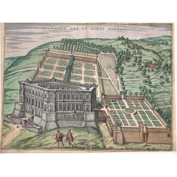
Caprarola Arx et Horti Farnesiani.
A nice view of the castle and gardens of the Farnese family, in Lazio. From the famous "Civitates orbis terrarum". Attractive original colors. French text on ve...
Date: Cologne, circa 1590
Selling price: ????
Please login to see price!
Sold in 2016
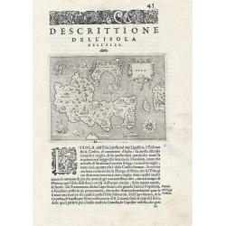
Descrittione dell' Isola dell'Elba.
The map depicts the Italian Mediterranean island of Elba. The map is orientated towards the north-west. From "L'Isole Piu Famose del Mondo", printed in Venice. ...
Date: Venice, 1590
Selling price: ????
Please login to see price!
Sold in 2019

Antverpia.
Prepared for Volume V of Braun & Hogenberg "Civitates Orbis Terrarum", which was first published in 1598. Two sheets joined, for a total dimension of 450mm ...
Date: Antwerp, circa 1590
Selling price: ????
Please login to see price!
Sold in 2017
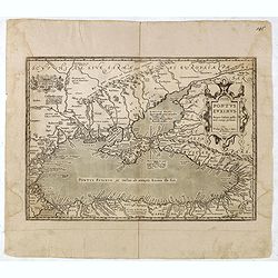
Pontus Euxinus Aequor Iafonio pulfatum remige premum.
Prepared by Ortelius after Mercator, and additional ancient sources as Plinius, Ovidius, Strabo, Apollonius, Procopius and Apianus.This map belongs to a series of histori...
Date: Antwerp, 1590
Selling price: ????
Please login to see price!
Sold in 2021

Naues a Gandauo submissae obuias Antwerpiensium naues fugant.
Striking and highly detailed rare copper engraved panoramic view of the siege of Antwerp, Belgium. In the middle we see the pontoon bridge by the Duke of Parma, Alessandr...
Date: Antwerp, 1590
Selling price: ????
Please login to see price!
Sold in 2016
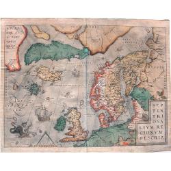
Septentrionalium Regionum Descrip.
Influential map of the Arctic. It includes Scandinavia, Iceland, Greenland and part of the North American continent, together with the legendary islands of the north: Dro...
Date: Antwerp, ca. 1590
Selling price: ????
Please login to see price!
Sold in 2015
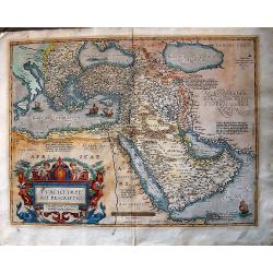
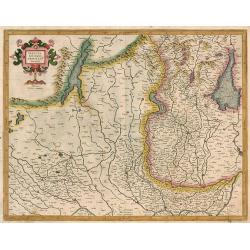
Turcici Imperii Descriptio.
The most famous of all the sixteenth-century maps of the Middle East. It extends from Greece to Arabia and covers the Cradle of Civilisation region. The Eastern Mediterra...
Date: Antwerp, ca 1590
Selling price: ????
Please login to see price!
Sold in 2016
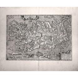
Islandia.
Probably the most famous (and among the most beautiful!) map of Iceland. On the south side an impressive collection of sea monsters. Polar bears on ice flows and volcanoe...
Date: Anwerp, ca 1590
Selling price: ????
Please login to see price!
Sold in 2016
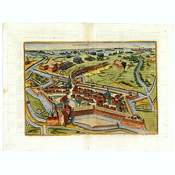
EYNDHOVEN - Nach dem Eindhoven mitt kriegs macht. . . .
Earliest printed bird's-eye view of Eindhoven. Showing the siege of April 13-23 1583. On April 22nd the young Count Carel van Mansfeld was taking the town after a 9 days ...
Date: Cologne, 1590
Selling price: ????
Please login to see price!
Sold in 2023
![[Koblentz]](/uploads/cache/37202-250x250.jpg)
[Koblentz]
Attractive birds eye view of the region around Coblenz. The Rhine and Mosel Rivers, fortified castles on the hillside and the fortified city below.With a decorative title...
Date: Basle 1550-1590
Selling price: ????
Please login to see price!
Sold in 2016
Salisbvrgensis Ivrisdictionis, locorumgue vicinorum vera..
From 'Theatrum Orbis Terrarum [Atlas of the Whole World]':published in Antwerp, Latin ed. pl. 57.The map is drawn in trompe l'oeil fashion, as though on a parchment of ir...
Date: Antwerp, 1590
Selling price: ????
Please login to see price!
Sold in 2025
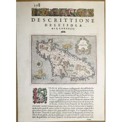
Dell ‘Isola Di San Lorenzo, Madagascar.
A beautiful map of Madagascar, from "L'Isole piu Famose del Mondo" - the most famous islands of the world by Thomas Porcacchi and engraved by Girolamo Porro. Th...
Date: Padua, 1590
Selling price: ????
Please login to see price!
Sold in 2018
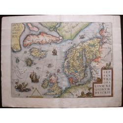
Septentrionalium Regionum Descrip.
A fascinating and important map of the North Atlantic by A. Ortelius in beautiful original colors.
Date: Antwerp, 1590
Selling price: ????
Please login to see price!
Sold in 2016