Browse Listings
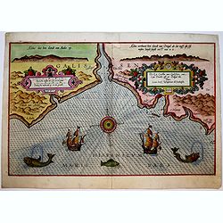
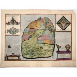
Die Zee Custen van Galissien, van Capo Daviles off tot Ortegal tho.
A detailed description of part of Galicia. Decorated by a colorful title cartouche and scale cartouche, one compass rose, several vessels and sea monsters. A very early e...
Date: Leiden, Plantijn, 1584-1586
Selling price: ????
Please login to see price!
Sold in 2017
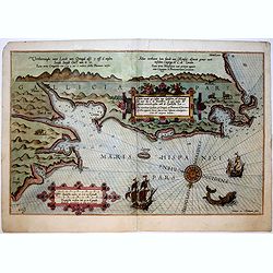
Beschrijvinge der Zee custen van Galissien beginnende van Capo de finisterre tot Camino...
A detailed description of part of Galicia. Decorated by a colorful title cartouche and scale cartouche, one compass rose, several vessels and sea monsters. A very early e...
Date: Leiden, Plantijn, 1584-1586
Selling price: ????
Please login to see price!
Sold in 2016
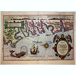
Caerte vande Zee Custen van Galissien, va Ortugal tot voer bij C. de Finisterre.
A fine and rare historical maritime map of detailed of part the coastline of Galicia (Northern Spain). Decorated by a colorful title cartouche and scale cartouche, one co...
Date: Leiden, Plantijn, 1584-1586
Selling price: ????
Please login to see price!
Sold in 2019
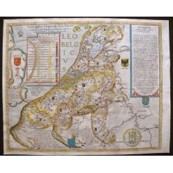
Leo Belgicus.
The very first version of the 'Lion' map from its creator Michael von Aitzing. The Netherlands is here for the first time depicted as a lion, a symbol of bravery and stre...
Date: Cologne, 1586
Selling price: ????
Please login to see price!
Sold in 2016
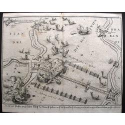
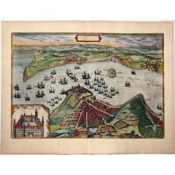
Siege on Antwerp - Ship bridge blown up.
Large anonymous engraving of a famous event on the 5th of April, 1585. On this day the ship bridge on the Schelde, build by the Duke of Parma, was blown up. However, by t...
Date: Cologne, 1586
Selling price: ????
Please login to see price!
Sold in 2021
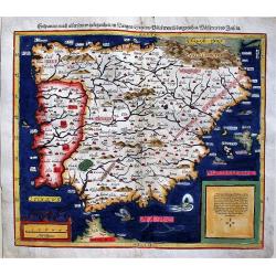
Hispanien nach aller seiner Gelegenheit / in Bergen Stetten / Volkeren Konigreichen Wasseren und Inseln.
An early map of Spain and Portugal from the famous Munster's Cosmography, one of the most influential geographical works of the 16th Century. This map, from the 1588 edit...
Date: Basle, 1586
Selling price: ????
Please login to see price!
Sold in 2018
![[Guerre des Pays-Bas] Geschichtsblätter (172 plates).](/uploads/cache/44450-250x250.jpg)
[Guerre des Pays-Bas] Geschichtsblätter (172 plates).
Illustrated with 170 plates dealing with Belgium, Dutch and German war sites (1567-1586) showing scenes of battles, sieges, executions, assassinations, parades, court sce...
Date: Cologne, c.1586
Selling price: ????
Please login to see price!
Sold
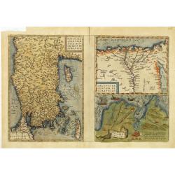
Natoliae Quae Olim Asia Minor, Nova de Scriptio / Carthaginis Celeberrimi Sinus Typus / Aegypti re Centior de Scriptio
Three detailed regional maps by Ortelius, from his Theatrum Orbis Terrarum, the first modern atlas of the world.The first map covers Asia Minor, Cyprus and the Eastern Me...
Date: Antwerp, 1587
Selling price: ????
Please login to see price!
Sold in 2012
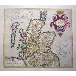
Scotia Regnum.
Printed in Duisberg 1587.
Date: Duisberg, 1587
Selling price: ????
Please login to see price!
Sold in 2014
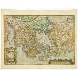
Graeciae Sophiani.
This is a beautiful depiction of ancient Greece. The map has a very attractive title cartouche in the shape of a Grecian temple in the bottom left-hand corner and a large...
Date: Antwerp, 1587
Selling price: ????
Please login to see price!
Sold in 2019
Palestinae sive totius terrae promissionis nova..
Ortelius famous map of Palestine based on Tilemann Stoltz's map, published in 1566. The shoreline runs from Berytus (Beirut) to the Nile Delta, reaching inland east of th...
Date: Antwerp, 1587
Selling price: ????
Please login to see price!
Sold in 2014
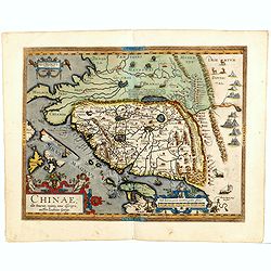
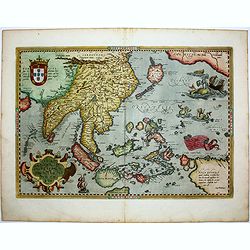
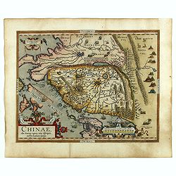
Chinae, olim Sinarum Regionis, nova descriptio. Auctore Ludovico Georgio.
The first map of China ever to appear in a Western atlas, west to the top. When this map appeared, it was by far the most accurate one of China.Japan is shown on a curiou...
Date: Antwerp, 1587
Selling price: ????
Please login to see price!
Sold in 2014
Russiae, Moscoviae et Tartariae Descriptio.
Engraved by Frans Hogenberg from an original of 1562 by Anthony Jenkinson of the English Muscovy Company. The map covers the region from the Gulf of Finland, Lithuania an...
Date: Antwerp, 1587
Selling price: ????
Please login to see price!
Sold in 2015
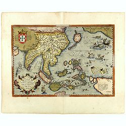
Indiae Orientalis, Insularumque Adiacientium Typus. . .
Striking handcolored example of Ortelius' map of SE Asia, Japan, and the Philippines, from the rare French text edition of 1587. The map includes Beach and other informat...
Date: Antwerp, 1587
Selling price: ????
Please login to see price!
Sold in 2016
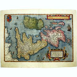
Angliae, scotiae, et Hiberniae, sive Britannicar insularum.
A classic, handsome and decorative map of ancient British Isles with north orientated to the east. Based on Mercator's 1564 map of the British isles and improved by Saxto...
Date: Antwerp, 1587
Selling price: ????
Please login to see price!
Sold in 2014
Russiae, Moscoviae et Tartariae Descriptio.
Engraved by Frans Hogenberg from an original of 1562 by Anthony Jenkinson of the English Muscovy Company. The map covers the region from the Gulf of Finland, Lithuania an...
Date: Antwerp, 1587
Selling price: ????
Please login to see price!
Sold in 2015
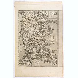
Natoliae Quae Olim Asia Minor, Nova de Scriptio.
Detailed map of Turkey, including Cyprus by Abraham Ortelius, from his "Theatrum Orbis Terrarum", the first modern atlas of the world.East to the top. Latin tex...
Date: Antwerp, 1587
Selling price: ????
Please login to see price!
Sold in 2015
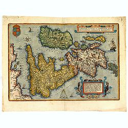
Angliae, scotiae, et Hiberniae, sive Britannicar : insularum descriptio.
A classic, handsome and decorative map of ancient British Isles with north orientated to the east. Based on Mercator's 1564 map of the British isles and improved by Saxto...
Date: Antwerp, 1587
Selling price: ????
Please login to see price!
Sold in 2017
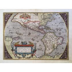
Americae Sive Novi Orbis.
This is the third state of the famous Ortelius map showing the western hemisphere without the prominent bulge in the South American coastline.
Date: Antwerp, 1587
Selling price: ????
Please login to see price!
Sold in 2016
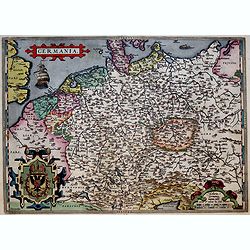
Germania.
Ortelius very decorative map of Germania, including Switzerland, Austria, Poland, The Netherlands and Belgium, from 'Theatrum Orbis Terrarum [Atlas of the Whole World]': ...
Date: Antwerp, 1587
Selling price: ????
Please login to see price!
Sold in 2019
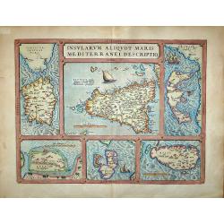
Insularum Aliquot Maris Mediterranei Descriptio.
Insularum Aliquot Maris Mediterranei Descriptio. Cum priuilegio'Sicily, Sardegne, Corfv, Zerbi, Elba, Malta. Six early maps on one sheet. Including the islands of Sicily,...
Date: Antwerp, 1587
Selling price: ????
Please login to see price!
Sold in 2017
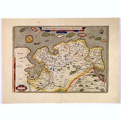
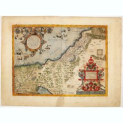
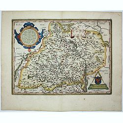
Frisiae Orientalis Descriptio.
Nice example of Ortelius' map of East Friesland, from the 1587 French edition of his Theatrum Orbis Terrarum, the first modern atlas of the world.This map includes a comp...
Date: Antwerp, 1587
Selling price: ????
Please login to see price!
Sold in 2017
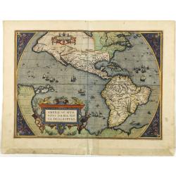
Americae sive novi orbis, nova descriptio.
In 1587, a new plate was engraved which appeared in editions from 1588 onwards. Of the three maps, this one is perhaps the most important. It is the most geographically a...
Date: Antwerp, 1587
Selling price: ????
Please login to see price!
Sold in 2018
Indiae Orientalis, Insularumque Adiacientium Typus. . .
Finely hand colored example of Ortelius' map of SE Asia, Japan, and the Philippines, etc from the rare French text edition of 1587. The map includes Beach and other infor...
Date: Antwerp, 1587
Selling price: ????
Please login to see price!
Sold in 2018
Chinae, olim Sinarum Regionis, nova descriptio. Auctore Ludovico Georgio.
WITHOUT TEXT ON VERSO. The first map of China ever to appear in a Western atlas, west to the top. The second state with "Las Philipinas" somewhere in 1587 added...
Date: Antwerp, ca. 1587
Selling price: ????
Please login to see price!
Sold in 2019
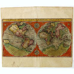
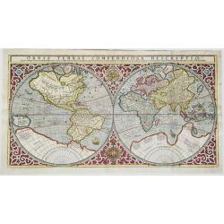
Orbis Terrae Compendiosa Descriptio.
Gerard Mercator's great world map of 1569 was condensed into double hemispherical form by his son Rumold. It first appeared in 1587 and was incorporated into his long-liv...
Date: Amsterdam, 1587
Selling price: ????
Please login to see price!
Sold in 2019
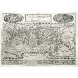
Peregrinationis Divi Pauli Typus Corographicus...
Ortelius's map of Paulus's travels from his Atlas Theatrum Orbis Terrarum. It covers the Mediterranean Sea from Italy and Sicily until the Near East and Egypt, with Cypru...
Date: Antwerp, 1587
Selling price: ????
Please login to see price!
Sold in 2019
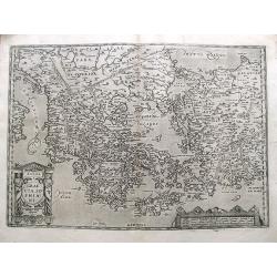
Graecia, Sophiani.
A detailed and decorative map of Greece and parts of Turkey, including many islands. Filled with place names and topographical details. Shows Troas (Troy). From the famou...
Date: Antwerp, 1587
Selling price: ????
Please login to see price!
Sold in 2019
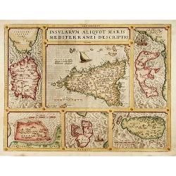
Insularum Aliquot Maris Mediterranei Descriptio.
The decorative composite map of six Mediterranean islands. The larger Sicily map is surrounded by maps of Sardinia, Corfu, Zerbi, Elba, and Malta. Each map is well detail...
Date: Antwerp, 1587
Selling price: ????
Please login to see price!
Sold
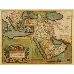
Turcici Imperii Descriptio.
Map of the Middle East, extending from Greece to Arabia and covering the Cradle of Civilisation region. This is a new plate copied from another Ortelius map of 1570 with ...
Date: Antwerp 1587
Selling price: ????
Please login to see price!
Sold
Orbis Terrae Compendiosa Descriptio.
Separately issued. Gerard Mercator's great world map of 1569 was condensed into double hemispherical form by his son Rumold. It first appeared in 1587 and was incorporate...
Date: Amsterdam, 1587
Selling price: ????
Please login to see price!
Sold
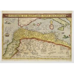
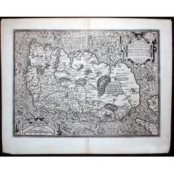
Barbariae et Biledulgerid, nova descriptio.
North-West Africa. Koeman speculated: In view of the important trading relationship between Antwerp and Africa, it is not impossible that the original was a manuscript ma...
Date: Antwerp 1587
Selling price: ????
Please login to see price!
Sold
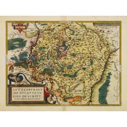
Lutzenburgensis Ducatus veriss descript.
Prepared by Jacob Surhon who made a manuscript map of Luxembourg for which he received 500 Livres from Charles V in 1551.For security reasons the map was not published. O...
Date: Antwerp 1587
Selling price: ????
Please login to see price!
Sold in 2014
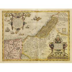
Palestinae sive totius terrae promissionis nova..
Ortelius famous map of Palestine based on Tilemann Stoltz\'s map, published in 1566. The shoreline runs from Berytus (Beirut) to the Nile Delta, reaching inland east of t...
Date: Antwerp, 1587
Selling price: ????
Please login to see price!
Sold in 2008
Wratislavia
Beautiful birdeye view of Wroclaw (Breslau) in Lower Silesia, Poland by Braun & Hogenberg from "Civitated Orbis Terrarum". Dated in plate 1587. ...
Date: Cologne, 1587
Selling price: ????
Please login to see price!
Sold in 2009
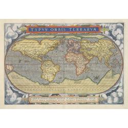
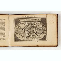
Typus Orbis Terrarum.
An state two (without date) of the second plate of this influential, and famous World map, issued in the first regularly produced world atlas. The map is a careful reduct...
Date: Antwerp, 1587
Selling price: ????
Please login to see price!
Sold in 2009
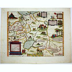
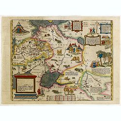
Moraviae, quae olim Marcomannorum Sedes, Corographia, A.D. Pavlo Fabritio Medico et Mathematico Descripta, et a Generosis Moraviae Baronibus Quibusdam corecta.
Very attractive full color map of Moravia, Slovakia prepared by Paul Fabritius in 1569. Showing fortified cities, towns, rivers, etc. With a fine Renaissance strapwork ca...
Date: Antwerp, 1587
Selling price: ????
Please login to see price!
Sold in 2013
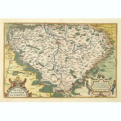
Regni Bohemiae Descriptio.
Standard map for the Czech Republic from the famous 'Theatrum Orbis Terrarum [Atlas of the Whole World]': published in Antwerp. With two large strapwork cartouches. The ...
Date: Antwerp, 1587
Selling price: ????
Please login to see price!
Sold in 2010
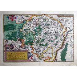
Lutzenburgensis Ducatus veriss descript .
Published by Abraham Ortelius (1527-98) in Antwerp, 1587. Written in a simple cartouche lower left: Lvtzenbvrgen Sis Dvatvs Veriss Descript. Iacobo Surhonio Montano aucto...
Date: Antwerp, 1587
Selling price: ????
Please login to see price!
Sold in 2010
Eryn - Hiberniae, Britannicae Insulae, Nova Descriptio - Irelandt
A beautiful map of Ireland from Ortelius' "Theatrum Orbis Terrarum" or Atlas of the whole world. This is one of the earliest maps of Ireland to present it with ...
Date: Antwerp, 1587
Selling price: ????
Please login to see price!
Sold in 2011
Moraviae, quae olim Marcomannorum Sedes, Corographia, A.D. Pavlo Fabritio Medico et Mathematico Descripta; et a Generosis Moraviae Baronibus Quibusdam corecta.
Very attractive map of Moravia, Slovakia prepared by Paul Fabritius in 1569. Showing fortified cities, towns, rivers, etc. With a fine Renaissance strapwork cartouche, an...
Date: Antwerp, 1587
Selling price: ????
Please login to see price!
Sold in 2011
Orbis Terrae Compendiosa Descriptio.
Full title on a bar above the map in two lines: 'Orbis Terrae Compendiosa Descriptio Quam ex Magna Universali Gerardi Mercatoris. Domino Richardo Gartho, Geographic ac ce...
Date: Amsterdam, 1587
Selling price: ????
Please login to see price!
Sold in 2020
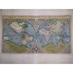
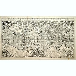
Orbis Terrae Compendiosa Descriptio
Extremely decorative, double-hemisphere world map colored by a contemporary hand. It shows elaborate strapwork borders, an armillary sphere, a compass rose, a galleon and...
Date: Amsterdam, after 1587
Selling price: ????
Please login to see price!
Sold in 2023
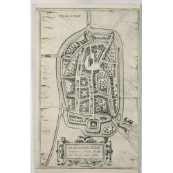
Franicher Nobiliu Hominum, in Frisia occidental, ut Plurimum Saedes.
A detailed bird’s-eye plan of Franeker located in Friesland, Germany. The cartographer was Jacob van Deventer and the plan is from Braun & Hogenberg. This is the r...
Date: Koln, 1588
Selling price: ????
Please login to see price!
Sold in 2021
Epitome. Du Theatre du Monde d'Abraham Ortelius.
Third French text edition in an oblong format of this illustrated treatise of geography, which is considered as the first modern pocket-atlas. The atlas was printed by Pl...
Date: Antwerp, 1588
Selling price: ????
Please login to see price!
Sold in 2020
Urbis Campensis..
A bird's eye view of the town of Kampen. From the first town book.
Date: Cologne, 1581-1588
Selling price: ????
Please login to see price!
Sold in 2020
![[WERDEN+ESSEN] Civitatis WERDENAE Exactiss: Descrip: [on sheet with:] Civitatis ESSENSIS Exactiss. Descrip.](/uploads/cache/84004-250x250.jpg)
[WERDEN+ESSEN] Civitatis WERDENAE Exactiss: Descrip: [on sheet with:] Civitatis ESSENSIS Exactiss. Descrip.
A nice decorative map with two panoramic views by Braun and Hogenberg: Werden and Essen.Werden is seen from the northwest, coming from the direction of Essen, in its loca...
Date: Cologne, 1588
Selling price: ????
Please login to see price!
Sold in 2020
Neus (Neuss)
Bird's-eye view of Neuss, published in the famous Stedenboek by Braun and Hogenberg. TRANSLATION OF CARTOUCHE TEXT RIGHT: The Roman king Philip captured Neuss around 1206...
Date: Cologne, 1588
Selling price: ????
Please login to see price!
Sold in 2021
Hamburgum (Hamburg)
Bird's-eye city plan of Hamburg with key to 27 locations.COMMENTARY BY BRAUN: "The Cimbrian Peninsula, the northernmost region of Germany, went by the name of Hutlan...
Date: Cologne, 1588
Selling price: ????
Please login to see price!
Sold in 2020
Monachium Utriusque Bavariae Civitas Primar. (Munich, München)
View of Munich by Braun and Hogenberg, after Georg Hoefnagel. With key to locations. TRANSLATION CARTOUCHE TOP: Munich, capital of the two Bavarias.CARTOUCHES BOTTOM LEFT...
Date: Cologne, 1588
Selling price: ????
Please login to see price!
Sold in 2020
![Sneecha, vulgo Sneeck ... [on sheet with] Doccum [and] Sloten [and] Ylsta. (Sneek, Doccum, Sloten, IJlst)](/uploads/cache/84373-250x250.jpg)
Sneecha, vulgo Sneeck ... [on sheet with] Doccum [and] Sloten [and] Ylsta. (Sneek, Doccum, Sloten, IJlst)
Antique map with four bird's-eye view plans by Braun and Hogenberg: Sneek, Doccum, Sloten, IJlst.SNEEK with CARTOUCHE: Sneecha, commonly known as Sneek. A town in West Fr...
Date: Cologne, 1588
Selling price: ????
Please login to see price!
Sold in 2020
![Bolzvardia vetus in Frisia Foederis Anzae teurinicae Op. [on sheet with] Stavria, vulgo Stavere ... [and] Harlinga [and] Hindelop. (Bolsward, Stavoren, Harlingen, Hindelopen)](/uploads/cache/84374-250x250.jpg)
Bolzvardia vetus in Frisia Foederis Anzae teurinicae Op. [on sheet with] Stavria, vulgo Stavere ... [and] Harlinga [and] Hindelop. (Bolsward, Stavoren, Harlingen, Hindelopen)
Four bird's-eye views - plans by Braun and Hogenberg: Bolsward, Stavoren, Harlingen and Hindelopen. The four views are made after Jacob van Deventer.BOLSWARD CARTOUCHE: B...
Date: Cologne, 1588
Selling price: ????
Please login to see price!
Sold in 2020
![Crempa Holsatiae Opp. ... [on sheet with] Reinholdsburga - Rendesburga. (Krempe - Rendsburg)](/uploads/cache/84375-250x250.jpg)
Crempa Holsatiae Opp. ... [on sheet with] Reinholdsburga - Rendesburga. (Krempe - Rendsburg)
Two bird's-eye views by Braun and Hogenberg: Krempe and Rendsburg.KREMPE : TRANSLATION OF CARTOUCHE TEXT: Krempe, at the instigation of Joannes Rantzau, Knight of the Gol...
Date: Cologne, 1588
Selling price: ????
Please login to see price!
Sold in 2020
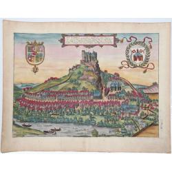
Arx Segeberga, Quondam Aelberga, Wagriam, Nobilem Holsatiae Regionem.. (Castle of Segeberg)
This lovely panoramic view depicts the Castle of Segeberg, built in the 12th century upon the Kalkberg, a 91-meter high rock. A small town surrounds the castle. In the fo...
Date: Cologne, 1588
Selling price: ????
Please login to see price!
Sold in 2021
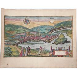
Munden - Mundensis, ad Visurgum flu: Saxoniae Urbis, genuina delineatio. (Hannoversch Münde)
Bird's-eye view of Hannoversch Münden by Braun and Hogenberg.TRANSLATION OF CARTOUCHE TEXT: A true-to-life drawing of the Lower Saxton town of Hannoversch Münden on the...
Date: Cologne, 1588
Selling price: ????
Please login to see price!
Sold in 2020
Schleiswygh. (Schleswig)
Bird's-eye view of Schleswig by Braun and Hogenberg.TRANSLATION OF CARTOUCHE TEXT: Gottorp. The castle of Gottorp, which came into the possession of the Dukes of Holstein...
Date: Cologne, 1588
Selling price: ????
Please login to see price!
Sold in 2021
![Ober Wesell [on sheet with] Boppart. (Oberwesel - Boppard)](/uploads/cache/84379-250x250.jpg)
Ober Wesell [on sheet with] Boppart. (Oberwesel - Boppard)
Two bird's-eye views by Braun and Hogenberg: Oberwesel and Boppard.OBERWESEL with TRANSLATION OF CARTOUCHE TEXT: Accurate drawing of the town of Vosavia, or Ficelia, on t...
Date: Cologne, 1588
Selling price: ????
Please login to see price!
Sold in 2020
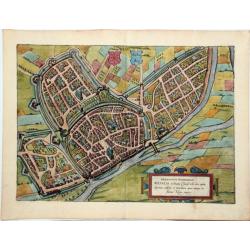
Wesalia in Ducatu Clivensi Urbs Clara Opibus. (Wesel)
Bird's-eye view plan of Wesel.TRANSLATION OF CARTOUCHE TEXT: Hermannus Hammelman. Wesel in the Duchy of Cleves, famous for its wealth, high status, buildings and trade, w...
Date: Cologne, 1588
Selling price: ????
Please login to see price!
Sold in 2021
![Lippe [on sheet with] Dortmund. (Lippstadt and Dortmund)](/uploads/cache/84382-250x250.jpg)
Lippe [on sheet with] Dortmund. (Lippstadt and Dortmund)
Two bird's-eye views on one sheet: Dortmund and Lippstadt, by Braun and Hogenberg.LIPPSTADT with TRANSLATION OF CARTOUCHE TEXT: Although the town of Lippe is subject to t...
Date: Cologne, 1588
Selling price: ????
Please login to see price!
Sold in 2020
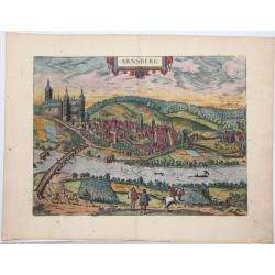
Arnsberg.
Bird's-eye view of Arnsberg by Braun and Hogenberg.COMMENTARY BY BRAUN: "The fair and noble land of Westphalia between the Weser and the Rhine stretches all the way ...
Date: Cologne, 1588
Selling price: ????
Please login to see price!
Sold in 2020
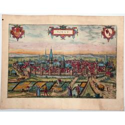
Soest.
Bird's-eye view of Soest, by Braun and Hogenberg.COMMENTARY BY BRAUN (on the verso): "After Münster, Soest is the wealthiest and largest city in Westphalia. [...] I...
Date: Cologne, 1588
Selling price: ????
Please login to see price!
Sold in 2020
Chilonium, vulgo Kyell. (Kiel)
Bird's-eye view of Kiel by Braun and Hogenberg.TRANSLATION OF CARTOUCHE TEXT: Chilonium, commonly called Kiel, an elegant old city in Holstein on an isthmus in the Baltic...
Date: Cologne, 1588
Selling price: ????
Please login to see price!
Sold in 2020
![Husemum Ducatus Slesvicensis ad Sinum Heveram Opp. [on sheet with] Haderslebia in Ducatu Slesvicensi. (Husum and Haderslev)](/uploads/cache/84386-250x250.jpg)
Husemum Ducatus Slesvicensis ad Sinum Heveram Opp. [on sheet with] Haderslebia in Ducatu Slesvicensi. (Husum and Haderslev)
Two bird's-eye views by Braun and Hogenberg: Husum and Haderslev.HUSUM with CARTOUCHE LEFT: Husum, town in the Duchy of Schleswig on the Hever coast.CARTOUCHE RIGHT: Reco...
Date: Cologne, 1588
Selling price: ????
Please login to see price!
Sold in 2020
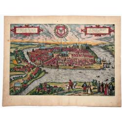
Hafnia vulgo Kopenhagen. (Copenhagen)
Two views of Copenhagen, by Georg Braun & Frans Hogenberg.
Date: Cologne, 1588
Selling price: ????
Please login to see price!
Sold in 2020
Topographia insulae Hvenae in celebri porthmo regni Daniae, quem vulgo oersunt vocant : effigiata Coloniae 1586 (Hven/Uraniborg - Tycho Brahe)
An antique map showing Uraniborg, which was a Danish astronomical observatory and alchemy laboratory established and operated by Tycho Brahe. It was built c. 15...
Date: Cologne, 1588
Selling price: ????
Please login to see price!
Sold in 2020
![Helsheborch [on sheet with] Lunden [and] Elbogen [and] Landeskron. (Helsingborg, Lund, Malmö, Landskrona)](/uploads/cache/84389-250x250.jpg)
Helsheborch [on sheet with] Lunden [and] Elbogen [and] Landeskron. (Helsingborg, Lund, Malmö, Landskrona)
Four bird's-eye views of Swedish towns by Braun and Hogenberg : Helsingborg, Lund, Malmö and Landskrona.HELSINGBORG with COMMENTARY BY BRAUN (on verso): "Helsingbor...
Date: Cologne, 1588
Selling price: ????
Please login to see price!
Sold in 2020
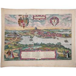
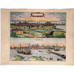
Freti Danici or Sundt Accuratiss Delineatio.
Bird's-eye view of The Sound with Helsingborg, Landskrona and Elbogen, by Georg Braun and Frans Hogenberg. Inset with a view of Kronenborg Castle.Translation of cartouche...
Date: Cologne, 1588
Selling price: ????
Please login to see price!
Sold in 2020
![Eisleben - Eislebia Comitatus Mansfeldiae Opp. [with] Tubingen - Tubinga.](/uploads/cache/84498-250x250.jpg)
Eisleben - Eislebia Comitatus Mansfeldiae Opp. [with] Tubingen - Tubinga.
Two bird's-eye views by Braun and Hogenberg on one sheet: Eisleben and Tübingen. EISLEBEN CARTOUCHE: Eisleben, a city in the County of Mansfeld. COMMENTARY BY BRAUN (on ...
Date: Cologne, 1588
Selling price: ????
Please login to see price!
Sold in 2020
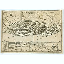
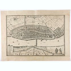
Urbis Campensis..
A bird's eye view of the town of Kampen.
Date: Cologne, 1581-1588
Selling price: ????
Please login to see price!
Sold in 2020

LIBER QUARTUS, URBIBUM PRAECIPUARUM TOTIUS MUNDI.
A fine example of the title page to the BRAUN & HOGENBERG 'CIVITATES..' VOL.4, together still joined the dedication sheet. The Civitates Orbis Terrarum (Atlas of Citi...
Date: Cologne, 1588
Selling price: ????
Please login to see price!
Sold in 2020
Cantuarbury.
A detailed city map in a 'bird's-eye view' of Canterbury, in original hand coloring, with the cathedral. Title at top centre, with left the crowned coat of arms of Englan...
Date: Cologne, 1588
Selling price: ????
Please login to see price!
Sold in 2020
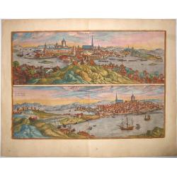
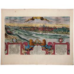
STOCKHOLM - STOCHOLM.
An old, antique map with two bird's-eye/panoramic views(North and South) of Stockholm, by Georg Braun and Frans Hogenberg, after Hieronymus Scholäus. Showing its active ...
Date: Cologne, 1588
Selling price: ????
Please login to see price!
Sold in 2021
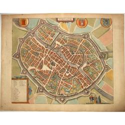
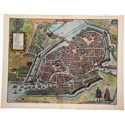
TORNACUM (Tournai, Belgium).
A detailed antique copper engraved view of the second oldest city in Belgium with its fortifications in decorative color. The view is supplemented by three city coats of ...
Date: Cologne, 1588
Selling price: ????
Please login to see price!
Sold in 2021
![Danorum Marca, uel Cimbricum. aut Daniae Regnum. . .[DENMARK]](/uploads/cache/84987-250x250.jpg)
Danorum Marca, uel Cimbricum. aut Daniae Regnum. . .[DENMARK]
The oldest preserved map of Denmark of Danish origin. Drawn by Marcus Jordan at the request of Duke Heinrich Rantzau, viceroy of Schleswig-Holstein. It is a new perceptio...
Date: Cologne, 1588
Selling price: ????
Please login to see price!
Sold in 2021
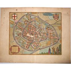
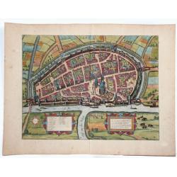
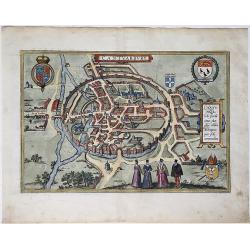
Lier - Lira, elegans et amoenum Brabantiae Opp: adeo, Ut multorum huius tractus nobilium in ocio degentium, a curise turba, iundissimus sit recessus.
Antique copper engraved map - a bird's-eye view plan of Lier by Braun and Hogenberg. An attractive map of the Brabantine town, belonging to the diocese of Antwerp. The to...
Date: Cologne, 1588
Selling price: ????
Please login to see price!
Sold in 2021
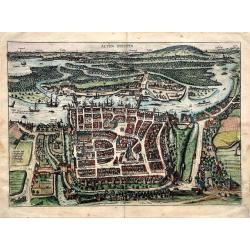
Alten Stettin.
A very decorative view of the city of Szczecin in Poland (its name was Stettin for much of its history). This city was a major port next to the mouth of the Oder River. O...
Date: Cologne, 1588
Selling price: ????
Please login to see price!
Sold in 2021
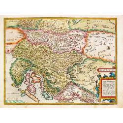
Illyricum
Ortelius' map of the region from Triest and Villach in the west, to Brod in the east, along the course of the Sava, centered on Zagreb and Novograd. Includes nice detail ...
Date: Antwerp, 1588
Selling price: ????
Please login to see price!
Sold in 2021
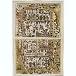
Ierusalem, et suburbia eius. . .
Plan of ancient Jerusalem and its suburbs as it looked at the time of Jesus Christ. TRANSLATION OF CAPTION: Jerusalem and its suburbs, as it flourished in the time of Chr...
Date: Antwerp, 1588
Selling price: ????
Please login to see price!
Sold in 2022
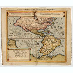
Americae Sive Novi Orbis, Nova Descriptio
Woodcut map by based on Abraham Ortelius' classic map of 1570, with the huge bulge in the southwest coastline of South America, the Ortelian western coastline of North Am...
Date: Basel, ca.1588
Selling price: ????
Please login to see price!
Sold in 2022
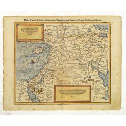
Syria / Cypern / Palestina Mesopotamia / Babylonia / zwen Arabia / mit Bergen / Wasseren und Stetten.
A famous wood block map of the Near East, including Cyprus, Palestine, Iran and Iraq, etc. From his "Cosmographia", that great compendium of Renaissance knowled...
Date: Basle, c.1588
Selling price: ????
Please login to see price!
Sold in 2012