Browse Listings
![[Map of Ukrania]](/uploads/cache/31494-250x250.jpg)
[Map of Ukrania]
Page with an early representation of Ukrania with the Black Sea. This text page with a fine wood block printed map is from the rare work "C. Iulii Solini Polyhistor,...
Date: Basle, Michael Isengrin, 1544
Selling price: ????
Please login to see price!
Sold in 2011
![[Map of Sicily]](/uploads/cache/31492-250x250.jpg)
[Map of Sicily]
Page with an early representation of Sicilia and the south of Italia. This text page with a fine wood block printed map is from the rare work "C. Iulii Solini Polyhi...
Date: Basle, Michael Isengrin, 1544
Selling price: ????
Please login to see price!
Sold in 2011
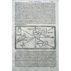
![[Map of Greece]](/uploads/cache/31493-250x250.jpg)
[Map of Greece]
Page with an early representation of Greece. This text page with a fine wood block printed map is from the rare work "C. Iulii Solini Polyhistor, Rerum Toto Orbe Mem...
Date: Basle, Michael Isengrin, 1544
Selling price: ????
Please login to see price!
Sold in 2016
![[Map of Europe]](/uploads/cache/31463-250x250.jpg)
[Map of Europe]
Page with an early representation of Europe. The continent is filled with the Alps mountains and the rivers Rhine and Danube.This text page with a fine wood block printed...
Date: Basle, Michael Isengrin, 1544
Selling price: ????
Please login to see price!
Sold in 2011
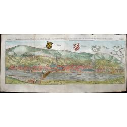
Heidelberg.
One of the two largest woodcuts from the 'Cosmographia' by Sebastian Münster. This is the attractively colored bird-eye view of Heidelberg. It is highly detailed, with a...
Date: Basel, 1544
Selling price: ????
Please login to see price!
Sold in 2019
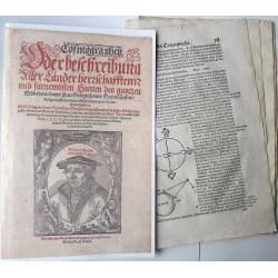
(Fragment from the Cosmographia)
This fragment of the Cosmographia by Sebastian Münster covers the entire mathematical and geographical introductions given in Book I. In these twenty-two pages Münster...
Date: Basel, 1544
Selling price: ????
Please login to see price!
Sold in 2020
Von dem Europa, das zu unsern zeiten die Christenheit under im begreifft und etwas von der Türkey.
An attractive map of Europe from the famous 'Cosmographia' by Sebastian Münster, in very nice colors. Europe has almost already taken the shape of Regina Europa. On ve...
Date: Basel, 1544
Selling price: ????
Please login to see price!
Sold in 2022
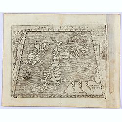
Tabula Europae I (Great Brittain)
The first edition of Munster's Ptolemaic map of Great Britain appeared in his "Geographia Universalis", first published in 1540. This was a new and important ed...
Date: Basel, Heinrich Petri, 1545
Selling price: ????
Please login to see price!
Sold in 2014
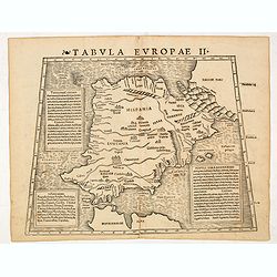
Tabula Europae II (Spain and Portugal)
The first edition of Munster's Ptolemaic map of Spain and Portugal appeared in his "Geographia Universalis", first published in 1540. This was a new and importa...
Date: Basel, Heinrich Petri, 1545
Selling price: ????
Please login to see price!
Sold
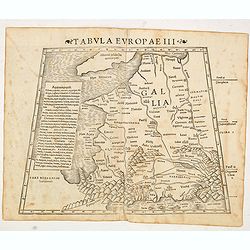
Tabula Europae III (France)
The first edition of Munster's Ptolemaic map of France appeared in his "Geographia Universalis", first published in 1540. This was a new and important edition o...
Date: Basel, Heinrich Petri, 1545
Selling price: ????
Please login to see price!
Sold in 2016
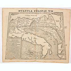
Tabula Europae V ( Adriatic Sea and the Balkans)
The first edition of Munster's Ptolemaic map of the Adriatic Sea and the Balkans appeared in his "Geographia Universalis", first published in 1540. This was a n...
Date: Basel, Heinrich Petri, 1545
Selling price: ????
Please login to see price!
Sold in 2014
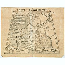
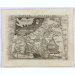
Tabula Europae VIII ( Russia, Ukraine, Baltic, Scandinavia)
The first edition of Munster's map of the Russia, Ukraine, Baltic, Scandinavia, based upon Claudius Ptolemy which appeared in his "Geographia Universalis", firs...
Date: Basel, Heinrich Petri, 1545
Selling price: ????
Please login to see price!
Sold in 2018
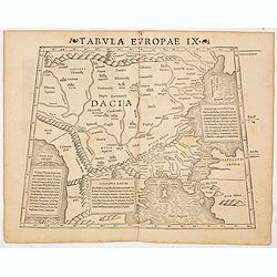
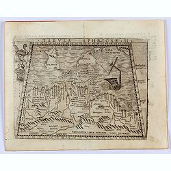
Tabula Europae IX ( Greece & Turkey)
The first edition of Munster's map of Greece & Turkey, based upon Claudius Ptolemy which appeared in his "Geographia Universalis", first published in 1540. ...
Date: Basel, Heinrich Petri, 1545
Selling price: ????
Please login to see price!
Sold in 2014
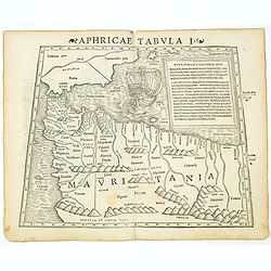
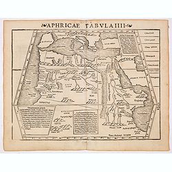
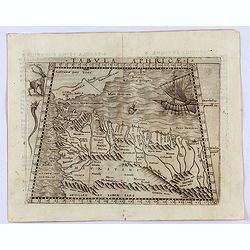
Aphricae Tabula I (Mauritania - present-day Morocco, Algeria, and Tunisia.)
The first edition of Munster's map of Mauritania - present-day Morocco, Algeria, and Tunisia, based upon Claudius Ptolemy which appeared in his "Geographia Universal...
Date: Basel, Heinrich Petri, 1545
Selling price: ????
Please login to see price!
Sold in 2019
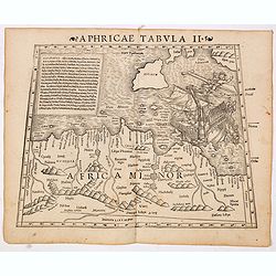
Aphricae Tabula II (Northern Africa and the Mediterranean showing parts of Sicily, Tunisia and Libya.)
The first edition of Munster's map of Northern Africa and the Mediterranean showing parts of Sicily, Tunisia and Libya, based upon Claudius Ptolemy which appeared in his ...
Date: Basel, Heinrich Petri, 1545
Selling price: ????
Please login to see price!
Sold in 2014
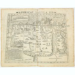
Aphricae Tabula III (Northern Africa and the Mediterranean, including Egypt.)
The first edition of Munster's map of Northern Africa and the Mediterranean, including Egypt, based upon Claudius Ptolemy which appeared in his "Geographia Universal...
Date: Basel, Heinrich Petri, 1545
Selling price: ????
Please login to see price!
Sold in 2020
Aphricae Tabula III (Northern Africa and the Mediterranean, including Egypt.)
The first edition of Munster's map of Northern Africa and the Mediterranean, including Egypt, based upon Claudius Ptolemy which appeared in his "Geographia Universal...
Date: Basel, Heinrich Petri, 1545
Selling price: ????
Please login to see price!
Sold in 2014
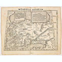
Tabula Asiae I (Turkey)
The first edition of Munster's map of Turkey, based upon Claudius Ptolemy which appeared in his "Geographia Universalis", first published in 1540. The Geographi...
Date: Basel, Heinrich Petri, 1545
Selling price: ????
Please login to see price!
Sold in 2016
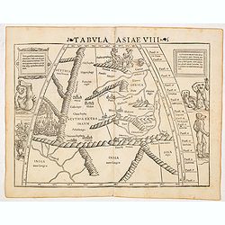
Tabula Asiae VIII (India & Central Asia with Monsters and Anthropomorphs)
The first edition of Munster's map of central Asia, based upon Claudius Ptolemy which appeared in his "Geographia Universalis", first published in 1540. This fa...
Date: Basel, Heinrich Petri, 1545
Selling price: ????
Please login to see price!
Sold in 2014
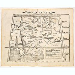
Tabula Asiae IX (Northern India and Pakistan)
The first edition of Munster's map of Northern India, present-day Iran, Afghanistan and Pakistan, with the delta of the Indus River graphically depicted. Based upon Claud...
Date: Basel, Heinrich Petri, 1545
Selling price: ????
Please login to see price!
Sold in 2016
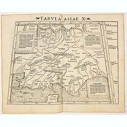
Tabula Asiae X (India)
The first edition of Münster's map of India and the Indian Ocean with the sources of the Indus and Ganges Rivers, based upon Claudius Ptolemy which appeared in his "...
Date: Basel, Heinrich Petri, 1545
Selling price: ????
Please login to see price!
Sold in 2016
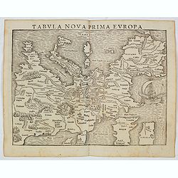
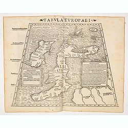
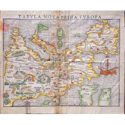
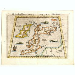
Tabula Nova Prima Europa. (Europe - 1st edition)
The FIRST edition of Munster's first modern map of Europe, with south oriented at the top which appeared in his "Geographia Universalis", first published in 154...
Date: Basel, Heinrich Petri, 1545
Selling price: ????
Please login to see price!
Sold in 2022
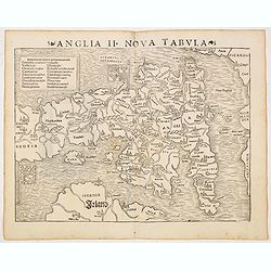
Anglia II Nova Tabula (British Isles)
The first edition of Munster's first printed separate map of England and Wales, with Scotland as far north as Edinburgh, the east coast of Ireland and north coast of Fran...
Date: Basel, Heinrich Petri, 1545
Selling price: ????
Please login to see price!
Sold in 2014
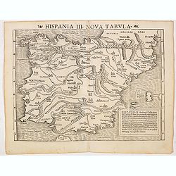
Hispania III Nova Tabula (Spain and Portugal)
The first edition of Munster's map of Spain and Portugal. Appeared in his "Geographia Universalis", first published in 1540. The Geographia was a new and import...
Date: Basel, Heinrich Petri, 1545
Selling price: ????
Please login to see price!
Sold in 2014
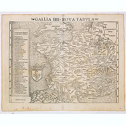
Gallia IIII Nova Tabula (France)
Sebastian Münster's map of France. Appeared in his "Geographia Universalis", first published in 1540. The Geographia was a new and important edition of Ptolemy...
Date: Basel, Heinrich Petri, 1545
Selling price: ????
Please login to see price!
Sold
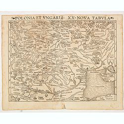
Polonia et Ungaria XX Nova Tabula (Poland and Hungary)
The first edition of Munster's map of Poland, Lithuania, the Ukraine, Muscovy and the Balkans. Appeared in his "Geographia Universalis", first published in 1540...
Date: Basel, Heinrich Petri, 1545
Selling price: ????
Please login to see price!
Sold in 2014
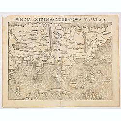
India extrema XXIIII Nova Tabula. (Asia)
One of the first European maps of Asia. Although quite crude, Münster's map does significantly improve upon the Ptolemaic model for the area. The coast of China begins t...
Date: Basel, Heinrich Petri, 1545
Selling price: ????
Please login to see price!
Sold in 2014
Tabula nova prima Europa.
This map comes from The first edition of Munster's "Geographia Universalis", first published in 1540. It is thus the first modern map of Europe, with south orie...
Date: Basel, Heinrich Petri, 1545
Selling price: ????
Please login to see price!
Sold in 2014
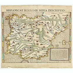
Hispaniam dividunt à Gallia. . . (Spain and Portugal)
Fine map of Spain and Portugal by Sebastian Münster, with an additional title in the top "hispanicae regionis nova descriptio". Sebastian Münster (1448-1552) ...
Date: Basel, ca 1545
Selling price: ????
Please login to see price!
Sold in 2016
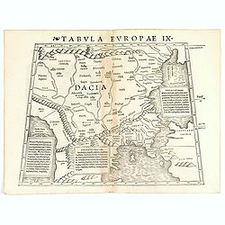
Tabula Europae IX ( Greece & Turkey).
The first edition of Munster's map of Greece & Turkey, based upon Claudius Ptolemy which appeared in his "Geographia Universalis", first published in 1540. ...
Date: Basel, Heinrich Petri, 1545
Selling price: ????
Please login to see price!
Sold in 2021
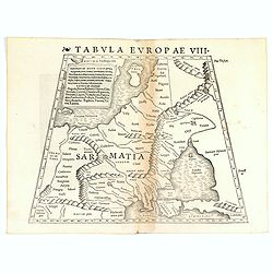
Tabula Europae VIII ( Russia, Ukraine, Baltic, Scandinavia).
The first edition of Münster's map of the Russia, Ukraine, Baltic, Scandinavia, based upon Claudius Ptolemy which appeared in his "Geographia Universalis", fir...
Date: Basel, Heinrich Petri, 1545
Selling price: ????
Please login to see price!
Sold in 2019
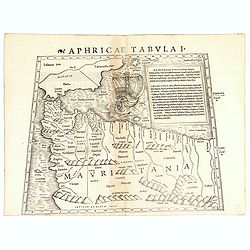
Aphricae Tabula I (Mauritania - present-day Morocco, Algeria, and Tunisia.)
The first edition of Münster's map of Mauritania - present-day Morocco, Algeria, and Tunisia, based upon Claudius Ptolemy which appeared in his "Geographia Universa...
Date: Basel, Heinrich Petri, 1545
Selling price: ????
Please login to see price!
Sold in 2018
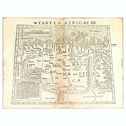
Tabula Africae III.
One of the earliest maps of Egypt, first published in the 1540 edition of Münster's Geographia and reprinted for subsequent editions of the Geographia and Cosmographia. ...
Date: Basel, Heinrich Petri, 1545
Selling price: ????
Please login to see price!
Sold in 2016
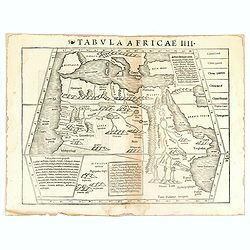
Tabula Africae IIII.
Uncommon first edition of one of the earliest maps of Egypt.Girolamo Ruscelli's edition of Ptolemy's Geographia included newly engraved copperplates by Giulio and Livio S...
Date: Basel, Heinrich Petri, 1545
Selling price: ????
Please login to see price!
Sold in 2016
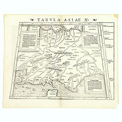
Tabula Asiae X (India)
The first edition of Munster's map of India and the Indian Ocean with the sources of the Indus and Ganges Rivers, based upon Claudius Ptolemy which appeared in his "...
Date: Basel, Heinrich Petri, 1545
Selling price: ????
Please login to see price!
Sold in 2017
![Tabula Asiae VI. [Arabia Felix]](/uploads/cache/39794-250x250.jpg)
Tabula Asiae VI. [Arabia Felix]
This fine woodcut is an early Ptolemaic map of the Arabian Peninsula here called 'Arabia Felix'. It is a fairly decent representation of the peninsula, although perhaps P...
Date: Basle, ca. 1545
Selling price: ????
Please login to see price!
Sold in 2018
Tabula Europae I (Great Britain).
Nice example of the rare third state of Ruscelli's map of the British Isles, based Claudius Ptolemy.The map first appeared in the 1561 edition of Ruscelli's edition of Pt...
Date: Basel, Heinrich Petri, 1545
Selling price: ????
Please login to see price!
Sold in 2017
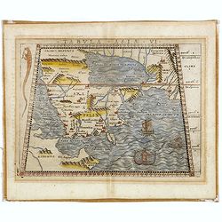
![Tabula Europae IX [Greece and Turkey]](/uploads/cache/98813-250x250.jpg)
Tabula Europae IX [Greece and Turkey]
First edition of Münster's map of Greece & Turkey plus the region west of the Black Sea and north of the Aegean and Adriatic Seas.Based on Claudius Ptolemy which app...
Date: Basel, 1545
Selling price: ????
Please login to see price!
Sold in 2019
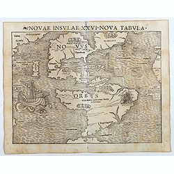
Novae Insulae XXVI Nova Tabula (America)
Rare second state of Münster's map of America which is the earliest map to show both continents of America and the first to use Magellan’s name, Mare Pacificum (Pacifi...
Date: Basel, Heinrich Petri, 1545
Selling price: ????
Please login to see price!
Sold in 2017
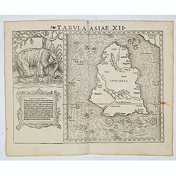
Tabula Asiae XII (Sri Lanka, with Elephant)
The FIRST edition of Munster's first modern map of Sri Lanka, which appeared in his "Geographia Universalis", first published in 1540. The Geographia was a new ...
Date: Basel, Heinrich Petri, 1545
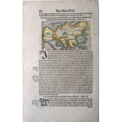
Europa, das ein Drittheil der Erden, nach gelegenheit unsern zeiten
Attractive woodcut map showing the European continent with South on top. From a German edition of Cosmographia by Sebastian Munster printed from Petri in Basel around 154...
Date: Basle, 1545
Selling price: ????
Please login to see price!
Sold in 2009
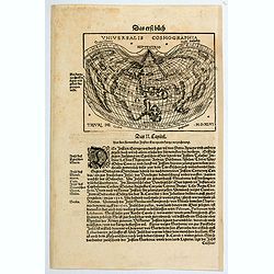
Universalis Cosmographia,
A very desirable cordiform (heart shaped) world map from Johann Honter's 'Rudimentum'. The map is a reduced version of Waldseemüller's and Apianus' earlier world maps. T...
Date: Zurich, ca. 1546
Selling price: ????
Please login to see price!
Sold in 2020
(Balearic Islands: Majorca, Minorca, Ibiza, Formentera)
The first separate printed maps of the Balearics, and the first regional map to name "Catalunya" (Catalonia) on the Spanish mainland! A wood cut page with Ital...
Date: Venice, 1528-1547
Selling price: ????
Please login to see price!
Sold in 2015
Tabula Asiae VI (Arabia).
Good example map of Arabia, the Red Sea and the Gulf, based upon Ptolemy, it includes a mermaid and a sea monster at the lower right corner.Giacomo Gastaldi's Atlas of 15...
Date: Venice, 1548
Selling price: ????
Please login to see price!
Sold in 2017
An early map of 'modern' southern Africa: Africa Nova Tabula.
An uncommon map showing all of Africa from the Horn of Africa and the Bight of Benin southward to the Cape of Good Hope. The information to produce this map was based on...
Date: Venice, 1548
Selling price: ????
Please login to see price!
Sold in 2011
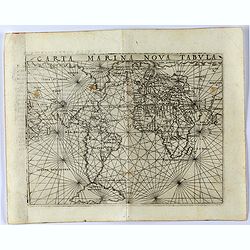
Carta Marina Nova Tabula
Gastaldi's maritime world map. Europe and North America are connected via a long land bridge. The bridge passes from North America to Tierra Del Bacalaos, Tierra del Labr...
Date: Venice, 1548
Selling price: ????
Please login to see price!
Sold in 2021
Terra Nueva
Gastaldi's map of Eastern USA from Giacomo Gastaldi's Atlas of 1548 which has been called the most comprehensive atlas, produced between Martin Waldseemüller's Geographi...
Date: Venice, 1548
Selling price: ????
Please login to see price!
Sold in 2023
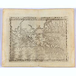
Nueva Hispania Tabula Nova.
Gastaldi's map of Mexico and Texas, from Giacomo Gastaldi's 1548 Atlas, which has been called the most comprehensive atlas, was produced between Martin Waldseemüller's G...
Date: Venice, 1548
Selling price: ????
Please login to see price!
Sold in 2021
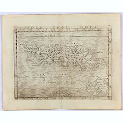
Insula Cuba Nova.
One of the earliest separately published maps of Cuba, with the Yslas de Lagartos (Cayman Islands). The map includes early appearances of Iamayea (Jamaica), Isola Espanol...
Date: Venice, 1548
Selling price: ????
Please login to see price!
Sold in 2021
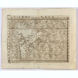
Tierra Nova
Gastaldi's map of South America from Giacomo Gastaldi's Atlas of 1548 which has been called the most comprehensive atlas, produced between Martin Waldseemüller's Geograp...
Date: Venice, 1548
Selling price: ????
Please login to see price!
Sold in 2022
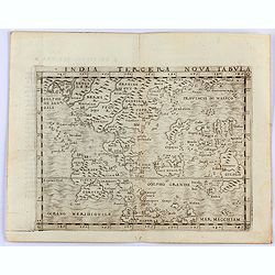
India Tercera Nova Tabula.
Gastaldi's map of South East Asia from Giacomo Gastaldi's Atlas of 1548 which has been called the most comprehensive atlas, produced between Martin Waldseemüller's Geogr...
Date: Venice, 1548
Selling price: ????
Please login to see price!
Sold in 2021
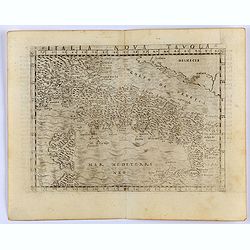
Italia Nova Tavola.
Gastaldi's modern map of Italy. From Giacomo Gastaldi's Atlas of 1548 which has been called the most comprehensive atlas, produced between Martin Waldseemüller's Geograp...
Date: Venice, 1548
Selling price: ????
Please login to see price!
Sold in 2021
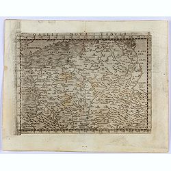
Gallia Nova Tavola.
Gastaldi's modern map of France. From Giacomo Gastaldi's Atlas of 1548, which has been called the most comprehensive atlas, produced between Martin Waldseemüller's Geogr...
Date: Venice, 1548
Selling price: ????
Please login to see price!
Sold in 2021
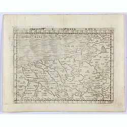
Prussia E. Livonia Nova.
Gastaldi's modern map of Eastern Europe. Covers coasts of Poland and Livonia. From Giacomo Gastaldi's Atlas of 1548 which has been called the most comprehensive atlas, pr...
Date: Venice, 1548
Selling price: ????
Please login to see price!
Sold in 2021
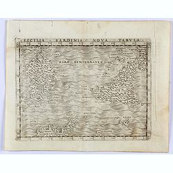
Sicilia Sardinia Nova Tabula.
Gastaldi's modern map of Sicily and Sardinia. From Giacomo Gastaldi's Atlas of 1548 which has been called the most comprehensive atlas, produced between Martin Waldseemü...
Date: Venice, 1548
Selling price: ????
Please login to see price!
Sold in 2023
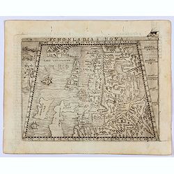
Sconladia Nova.
Gastaldi's modern map of Scandinavia, Iceland, and the Baltic According to Bill Ginsberg the map was "built upon previous publications, in particular, the representa...
Date: Venice, 1548
Selling price: ????
Please login to see price!
Sold in 2022
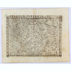
Anglia e Hibernia Nova
Gastaldi's modern map of the British Isles. It is one of the earliest obtainable modern maps of the British Isles.From Giacomo Gastaldi's Atlas of 1548, which has been ca...
Date: Venice, 1548
Selling price: ????
Please login to see price!
Sold in 2021
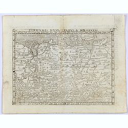
Germania nova Tabula MDXXXXII.
Gastaldi's modern map of Germany, from the Low Countries to Poland in the North and covering Germany and part of Hungary in the South.It is one of the earliest obtainable...
Date: Venice, 1548
Selling price: ????
Please login to see price!
Sold in 2021
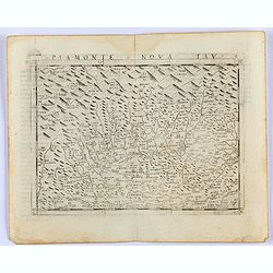
Piamonte Nova Tav.
Gastaldi's modern map of Piemonte, Northern Italy. It is one of the earliest obtainable modern maps of the region.From Giacomo Gastaldi's Atlas of 1548 which has been cal...
Date: Venice, 1548
Selling price: ????
Please login to see price!
Sold in 2022
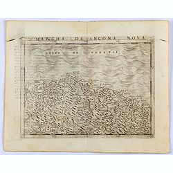
Marcha de Ancona Nova.
Gastaldi's modern map of Ancona. It is one of the earliest obtainable modern maps of the region.From Giacomo Gastaldi's Atlas of 1548 which has been called the most compr...
Date: Venice, 1548
Selling price: ????
Please login to see price!
Sold in 2021
Tabula Europae I. (British Isles)
Gastaldi's map of the British Isles is based on Ptolemy. It is one of the earliest obtainable maps of the region.From Giacomo Gastaldi's Atlas of 1548, which has been ca...
Date: Venice, 1548
Selling price: ????
Please login to see price!
Sold in 2021
Tabula Aphricae II.
Gastaldi's map of North Africa and part of the Mediterranean, including Malta, Sardinia and Sicily. Embellished with two mythical birds and a ship wreck off the coast. Ba...
Date: Venice, 1548
Selling price: ????
Please login to see price!
Sold in 2022
Tabula Aphricae I. (Morocco & Southeast Spain)
Gastaldi's map of North Africa with Morocco and the Balearic Islands to the Pillars of Hercules. Based upon Ptolemy.Embellished is a sailing ship, sea monster and several...
Date: Venice, 1548
Selling price: ????
Please login to see price!
Sold in 2023
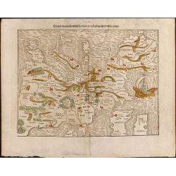
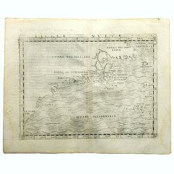
Tabula Europae VIII. (Russia, Ukraine, Baltic, Scandinavia)
Gastaldi's map showing the Baltic in the North and the Black Sea in the south. Based upon Ptolemy.Embellished is a sailing ship, sea monster and several curious animals.I...
Date: Venice, 1548
Selling price: ????
Please login to see price!
Sold in 2022
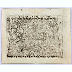
Tabula Europae VII. (Sicily, Sardinia and Malta)
Gastaldi's map showing Sicily, Sardinia and Malta. Based upon Ptolemy.Embellished is a sailing ship, sea monster and several curious animals.It is one of the earliest obt...
Date: Venice, 1548
Selling price: ????
Please login to see price!
Sold in 2023
![Tabula Asiae XI. [Southeast Asia]](/uploads/cache/47432-250x250.jpg)
Tabula Asiae XI. [Southeast Asia]
Gastaldi's map showing Southeast Asia and the Indian Ocean based upon Ptolemy.It is one of the earliest obtainable maps of the region .From Giacomo Gastaldi's Atlas of 15...
Date: Venice, 1548
Selling price: ????
Please login to see price!
Sold in 2023
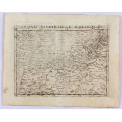
Flandria Barbantia e Holanda No.
Gastaldi's modern map of the Low Countries of the Netherlands, Belgium and Luxembourg. It includes parts of England, France and Germany.According to van der Heijden This ...
Date: Venice, 1548
Selling price: ????
Please login to see price!
Sold in 2025
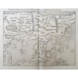
Tabula orientalis regionis, Asiae scilicet extremas complectens terras et regna.
Very early woodcut printed map of the Asia, published in the monumental Cosmographia by Sebastian Münster. The maps shows all of Asia, parts of the Indian Ocean with Mad...
Date: Basel, ca. 1550
Selling price: ????
Please login to see price!
Sold in 2019
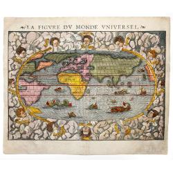
LA FIGURE DU MONDE UNIVERSEL.
Beautiful example of Sebastian Münster's oval new world map, from the Cosmographia of 1550. Relief is shown pictorially. The map is embellished with fierce sea monsters ...
Date: Basel, ca 1550
Selling price: ????
Please login to see price!
Sold in 2020
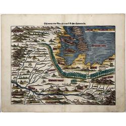
SCLAVONIA ODER WINDISCH MARCK, BOSSEN, CRABATEN (Croatia, Dalmatia)
A beautifully colored, antique woodcut map of Dalmatia, Bosnia, Slovenia, Croatia.
Date: Basle, 1550
Selling price: ????
Please login to see price!
Sold in 2021
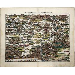
Transilvania.
A beautifully colored map of the "Seven Cities" also known as 'Transsylvania', today western Romania.
Date: Basle, 1550
Selling price: ????
Please login to see price!
Sold in 2021
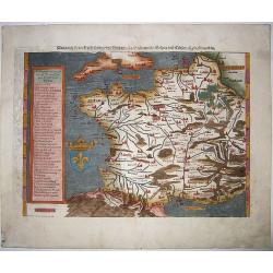
Das gantz Franckreich..Belgica und Celtica. . .
This fine and beautifully hand colored original antique map of modern contemporary France in the mid 16th century was published by Sebastian Münster in the 1550's. Date ...
Date: Basel, ca 1550
Selling price: ????
Please login to see price!
Sold in 2020
![Das Erst General, inhaltend die beschreibung und den Circkel des gantzen Erdtrichs und Moese.['Modern World' map]](/uploads/cache/84759-250x250.jpg)
Das Erst General, inhaltend die beschreibung und den Circkel des gantzen Erdtrichs und Moese.['Modern World' map]
Münster’s modern map of the world, on an oval projection, was first published in his ‘Geographia’ of 1540. The early issues are distinguished by the absence of ...
Date: Basel, ca.1550
Selling price: ????
Please login to see price!
Sold in 2020
![Ptolemaisch General Tafel / begreiffend die halbe Kugel der Welt. [World map after Ptolemy]](/uploads/cache/84755-250x250.jpg)
Ptolemaisch General Tafel / begreiffend die halbe Kugel der Welt. [World map after Ptolemy]
A nice full color example of Munster's first ancient map of the World, based upon the writings of Ptolemy. At the advent of printing in the 15th century, the geographical...
Date: Basel, ca. 1550
Selling price: ????
Please login to see price!
Sold in 2021
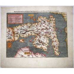
Das Engelland, mit dem anstossenden Reich Schottland. . . Britannia. . .
An antique map of England and Wales, with parts of Scottland and Ireland. Full title : Engellandt/ mit dem anstossenden Reich Schottlandt/ so vor zeiten Albion und Britan...
Date: Basel ca 1550
Selling price: ????
Please login to see price!
Sold in 2020
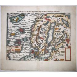
Gemeine beschreibung aller Mitnaechtigen Laender, Schweden, Gothen, Nordwegien, Dennmarck, sc.
An early Sebastian Münster's woodcut map of Scandinavia, based on the 'Carta Marina' of Olaus Magnus, 1539. The map includes Norway, Sweden, Finland, Denmark, Iceland, S...
Date: Basel, ca 1550
Selling price: ????
Please login to see price!
Sold in 2020
![Die dritte Tafel des Rheinstroms, inhaltendt das Nider Teutschlandt. [Course of the Rhine from approx. Remagen to the North Sea]](/uploads/cache/84789-250x250.jpg)
Die dritte Tafel des Rheinstroms, inhaltendt das Nider Teutschlandt. [Course of the Rhine from approx. Remagen to the North Sea]
Wood block printed map of mostly the Netherlands and Belgium - designed as third part of the course of the Rhine, by Sebastian Munster.One of the Earliest Modern Maps on ...
Date: Basel, 1550
Selling price: ????
Please login to see price!
Sold in 2020
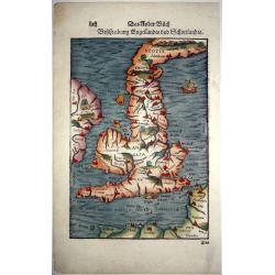
Beschreibung Engellandts und Schottlandts.
A full-page woodcut map of England, Scotland, Wales, and part of Ireland, published in Basel, circa 1550. This charming woodblock map of Britain is the base for the Merca...
Date: Basel, ca 1550
Selling price: ????
Please login to see price!
Sold in 2021
![BEYDE STAETT GENFF. . .[Geneva]](/uploads/cache/85034-250x250.jpg)
BEYDE STAETT GENFF. . .[Geneva]
An uncommon and early woodblock panoramic view of Geneva as a medieval walled city on the shores of Lake Leman. The skyline is dominated by the Cathedral of St. Peter, wh...
Date: Basel, ca 1550
Selling price: ????
Please login to see price!
Sold in 2021
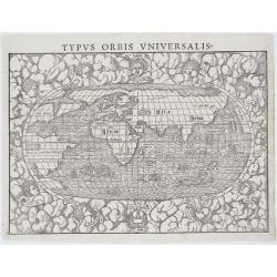
Typus Orbis Universalis.
​Münster’s map of the World. It is one of the most recognised world maps of the 16th Century. This example is from the second woodblock, which includes the e...
Date: Basel, 1550
Selling price: ????
Please login to see price!
Sold in 2021