Please login to see price!.
Subscribe to be notified if similar examples become available.
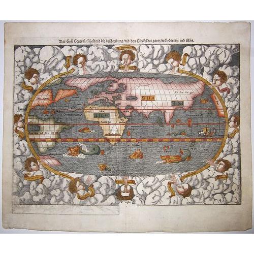
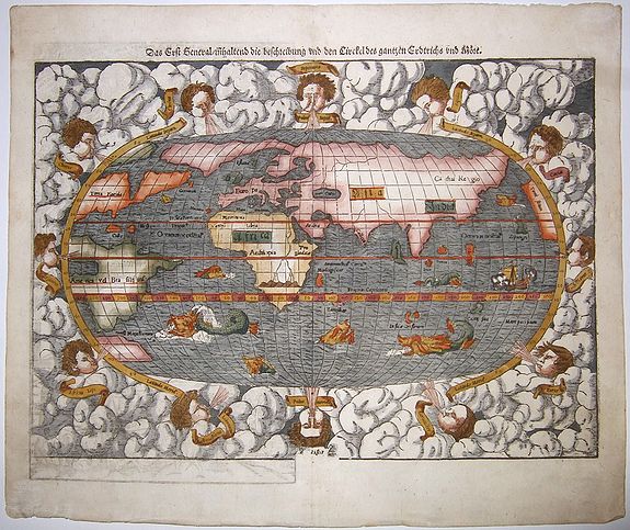
Das Erst General, inhaltend die beschreibung und den Circkel des gantzen Erdtrichs und Moese.['Modern World' map] |
||||||||||||||||||||
|
||||||||||||||||||||
|
|
||||||||||||||||||||
|
Selling price: $...
Please login to see price! Sold in 2020 Missed this item! Be the first to get notified about our newly added listings. Add your name to our mailing list. Feel free to contact us if you have a question about this item. |
Virtual Collection - Save and collect this or any of your favorite items in one place.
If you want to save the items permanently, please sign in or create account first. |
|||||||||||||||||||
Description
Münster’s modern map of the world, on an oval projection, was first published in his ‘Geographia’ of 1540. The early issues are distinguished by the absence of the woodcutter David Kandel’s initials from the border lower left, which appeared in maps printed from the second block onwards.
The border of the map is highly decorative, including roiling clouds and ‘lusty’ wind-heads. This is in sharp contrast to the rather sketchy geography: the continents are shown in rough outline only, but is still clearly based on a ‘combination of information derived from Verrazzano’s explorations of 1522–1524, when the waters of the Chesapeake Bay were mistaken for the Indian Ocean, and reports of Carter’s voyages of 1534–1535 up the St. Lawrence seaway into the Great Lakes vainly searching for the north-west passage’ (Shirley).
Sea monsters frolic in the Southern Ocean, or 'Oceanus Australis', where no large continent is hypothesised to hide. Instead, a small unlabelled landmass lies south of the Straits of Magellan, which were discovered less than two decades before this map was produced.
Each ocean is labeled with a text block, made by inserting metal type into the woodblock, and this map contains the earliest naming of the Pacific Ocean ('Mare Pacificum').
Münster here adds to the contemporary confusion over 'Taprobana' and Ceylon. He depicts a Sumatra-shaped 'Taprobana' on the west side of the Indian subcontinent, while Java is in the approximately correct size and position of Sri Lanka. 'Taprobana' was what the Greeks had called Sri Lanka, but late-medieval and early modern geographers also applied the toponym to Sumatra and a phantom island.
To add further to the confusion, farther south is 'Calensuan', which is spelled as Callenzuan on Waldseemüller’s 1507 world map and 'Calensuan' on Juan Vespucci’s 1524 world map. The origin of this island is unknown, but it may too be a corruption of Ceylon, or Sri Lanka.
Münster seems to have hedged his bets and combined the various hypotheses while also placing the East Indies farther west than they really are. He also includes 'Gilolo', today known as Halmahera, the largest island in the Maluku Islands in Indonesia. The triangular island Porne denotes Borneo.
North America is broken up, with the bulk of the continent at the left and the west coast appearing briefly on the right side of the oval projection. Münster is non-committal as to the continuity of North and South America; an unbroken Central America is implied but is not clearly shown thanks to a wind head and the curve of the projection.
Interestingly, all of North America is called 'Terra Florida'. The northeast is labeled 'Francista', a reference to the French efforts there. To the northeast is a large island referring to the land of the 'Bacalhos', i.e. bacalao or salt cod, a reference to the Basque fisherman seeking cod in the area.
Finally, a note in the northwest explains that here lies a strait to the Moluccas, a hopeful reference to the Northwest Passage.
Münster’s map is a fascinating mixture of information derived from the most up-to-date sources he could access. He maintained a large network of sources, written and printed, and informants who fed him information about the shape of the world. This map reveals several of his sources.
For example, Münster’s reference to the French in North America shows familiarity with Giovanni de Verrazano's explorations on behalf of King Francis I of France in 1522 to 1524. On this voyage, Verrazano mistook the Chesapeake for the Indian Ocean and named the land north of Florida Francesca to mark a French claim.
Another source of information was brought back by Jacques Cartier, who also traveled to New France for Francis I in the mid-1530s. Cartier traveled up the St. Laurence, ever in search of the Northwest Passage, in 1534 and 1535. Although he did not find the Passage, he did make permanent the French claim to imperial expansion on that landmass. Münster likely heard of both voyages via voyage accounts and word-of-mouth.
Close knowledge of Magellan’s historic circumnavigation is evident as well. Münster most likely had access to the maps and manuscripts written by Antonio Pigafetta, partially published in Paris in 1525, as well as Maximilianus Transylvanus’ published account based on Christopher Haro’s interviews of survivors, published in 1523 in Cologne.
Finally, access to other maps and geographies is evident, including Martin Waldseemüller’s 1507 map of the world as mentioned above. As a trained geographer, Münster clearly had studied Marco Polo, as evidenced by his placement of Japan (Zipagri) at roughly 20 degrees north latitude.
He also was familiar with Ptolemy’s ideas. For example, Münster follows the traditional Ptolemaic geography in Africa by depicting twin lakes on the same latitude near mountains. Ptolemy thought this configuration to be the source of the Nile River.
Münster’s methodology of careful consultation of a variety of sources, old and new, was common for geographers of his time. However, Münster’s work, first in his 'Geographia' (1540) and later in his 'Cosmographia' (1544), would have a deep, long-lasting effect on European geography. This world map was one of the most influential depictions of the world to date and would be studied by Ortelius, Mercator, and others.
Sebastian Münster, a German geographer, cartographer, Hebraist, and theologian, was born in Ingelheim, near Mainz In 1505, he went to Heidelberg to enter the Franciscan order. In 1507 he went to Louvain, where he studied mathematics, geography, and astronomy. In 1509 Münster became a student of Konrad Pelikan, who taught Hebrew and Greek as well as mathematics and cosmography. In 1518 he completed his studies at the University of Tübingen. He was the favorite of the famous mathematician and astronomer Johann Stöffler.
In 1524, Münster was appointed professor of Hebrew at Heidelberg University. In 1525 he published his first map as part of a broadside: The Instrument of the Suns combined a map, calendar, astrological almanac, sundial, and nocturnal on one attractive sheet, suitable for wall mounting.
In 1540 he published a Latin edition of Ptolemy's Geographia with illustrations. He based this edition on the Latin translation by Willibald Pirkheimer and produced new maps to supplement the Ptolemaic maps. The twenty-seven maps of the Ptolemaic canon are supplemented by twenty-one new maps. Further editions appeared in 1541 and 1542.In 1544 he published the Cosmographia, a bulky book with 659 pages and some 520 woodcuts. Maps in this edition included three maps from the Ptolemaic canon and fourteen modern maps (from previous editions of the Geographia), as well as nine new maps. Later editions (1545, 1546, 1548) enlarged the Cosmographia. The 1550 edition contains cities, portraits, and costumes. These editions in both Latin and German constitute the full fruition of Münster's dream of a comprehensive geography.
The 'Cosmographia' was one of the most successful works of the 16th century. It passed through 24 editions in 100 years, in different languages, including Latin, French, Italian, English, and even Czech. The last German edition was published in 1628. He died in Basel of the plague in 1552.
As a cartographer, Münster deserves special recognition for formulating a plan for a comprehensive and uniform map of a country. As a geographer, his greatest achievement was the 'Cosmographia'. (Karrow). Date of the first edition: 1540; Date of this map: 1550's.
Reference: Shirley, World, 77.
The border of the map is highly decorative, including roiling clouds and ‘lusty’ wind-heads. This is in sharp contrast to the rather sketchy geography: the continents are shown in rough outline only, but is still clearly based on a ‘combination of information derived from Verrazzano’s explorations of 1522–1524, when the waters of the Chesapeake Bay were mistaken for the Indian Ocean, and reports of Carter’s voyages of 1534–1535 up the St. Lawrence seaway into the Great Lakes vainly searching for the north-west passage’ (Shirley).
Sea monsters frolic in the Southern Ocean, or 'Oceanus Australis', where no large continent is hypothesised to hide. Instead, a small unlabelled landmass lies south of the Straits of Magellan, which were discovered less than two decades before this map was produced.
Each ocean is labeled with a text block, made by inserting metal type into the woodblock, and this map contains the earliest naming of the Pacific Ocean ('Mare Pacificum').
Münster here adds to the contemporary confusion over 'Taprobana' and Ceylon. He depicts a Sumatra-shaped 'Taprobana' on the west side of the Indian subcontinent, while Java is in the approximately correct size and position of Sri Lanka. 'Taprobana' was what the Greeks had called Sri Lanka, but late-medieval and early modern geographers also applied the toponym to Sumatra and a phantom island.
To add further to the confusion, farther south is 'Calensuan', which is spelled as Callenzuan on Waldseemüller’s 1507 world map and 'Calensuan' on Juan Vespucci’s 1524 world map. The origin of this island is unknown, but it may too be a corruption of Ceylon, or Sri Lanka.
Münster seems to have hedged his bets and combined the various hypotheses while also placing the East Indies farther west than they really are. He also includes 'Gilolo', today known as Halmahera, the largest island in the Maluku Islands in Indonesia. The triangular island Porne denotes Borneo.
North America is broken up, with the bulk of the continent at the left and the west coast appearing briefly on the right side of the oval projection. Münster is non-committal as to the continuity of North and South America; an unbroken Central America is implied but is not clearly shown thanks to a wind head and the curve of the projection.
Interestingly, all of North America is called 'Terra Florida'. The northeast is labeled 'Francista', a reference to the French efforts there. To the northeast is a large island referring to the land of the 'Bacalhos', i.e. bacalao or salt cod, a reference to the Basque fisherman seeking cod in the area.
Finally, a note in the northwest explains that here lies a strait to the Moluccas, a hopeful reference to the Northwest Passage.
Münster’s map is a fascinating mixture of information derived from the most up-to-date sources he could access. He maintained a large network of sources, written and printed, and informants who fed him information about the shape of the world. This map reveals several of his sources.
For example, Münster’s reference to the French in North America shows familiarity with Giovanni de Verrazano's explorations on behalf of King Francis I of France in 1522 to 1524. On this voyage, Verrazano mistook the Chesapeake for the Indian Ocean and named the land north of Florida Francesca to mark a French claim.
Another source of information was brought back by Jacques Cartier, who also traveled to New France for Francis I in the mid-1530s. Cartier traveled up the St. Laurence, ever in search of the Northwest Passage, in 1534 and 1535. Although he did not find the Passage, he did make permanent the French claim to imperial expansion on that landmass. Münster likely heard of both voyages via voyage accounts and word-of-mouth.
Close knowledge of Magellan’s historic circumnavigation is evident as well. Münster most likely had access to the maps and manuscripts written by Antonio Pigafetta, partially published in Paris in 1525, as well as Maximilianus Transylvanus’ published account based on Christopher Haro’s interviews of survivors, published in 1523 in Cologne.
Finally, access to other maps and geographies is evident, including Martin Waldseemüller’s 1507 map of the world as mentioned above. As a trained geographer, Münster clearly had studied Marco Polo, as evidenced by his placement of Japan (Zipagri) at roughly 20 degrees north latitude.
He also was familiar with Ptolemy’s ideas. For example, Münster follows the traditional Ptolemaic geography in Africa by depicting twin lakes on the same latitude near mountains. Ptolemy thought this configuration to be the source of the Nile River.
Münster’s methodology of careful consultation of a variety of sources, old and new, was common for geographers of his time. However, Münster’s work, first in his 'Geographia' (1540) and later in his 'Cosmographia' (1544), would have a deep, long-lasting effect on European geography. This world map was one of the most influential depictions of the world to date and would be studied by Ortelius, Mercator, and others.
Sebastian Münster, a German geographer, cartographer, Hebraist, and theologian, was born in Ingelheim, near Mainz In 1505, he went to Heidelberg to enter the Franciscan order. In 1507 he went to Louvain, where he studied mathematics, geography, and astronomy. In 1509 Münster became a student of Konrad Pelikan, who taught Hebrew and Greek as well as mathematics and cosmography. In 1518 he completed his studies at the University of Tübingen. He was the favorite of the famous mathematician and astronomer Johann Stöffler.
In 1524, Münster was appointed professor of Hebrew at Heidelberg University. In 1525 he published his first map as part of a broadside: The Instrument of the Suns combined a map, calendar, astrological almanac, sundial, and nocturnal on one attractive sheet, suitable for wall mounting. In 1540 he published a Latin edition of Ptolemy's Geographia with illustrations. He based this edition on the Latin translation by Willibald Pirkheimer and produced new maps to supplement the Ptolemaic maps. The twenty-seven maps of the Ptolemaic canon are supplemented by twenty-one new maps. Further editions appeared in 1541 and 1542.In 1544 he published the Cosmographia, a bulky book with 659 pages and some 520 woodcuts. Maps in this edition included three maps from the Ptolemaic canon and fourteen modern maps (from previous editions of the Geographia), as well as nine new maps. Later editions (1545, 1546, 1548) enlarged the Cosmographia. The 1550 edition contains cities, portraits, and costumes. These editions in both Latin and German constitute the full fruition of Münster's dream of a comprehensive geography.
The 'Cosmographia' was one of the most successful works of the 16th century. It passed through 24 editions in 100 years, in different languages, including Latin, French, Italian, English, and even Czech. The last German edition was published in 1628. He died in Basel of the plague in 1552.
As a cartographer, Münster deserves special recognition for formulating a plan for a comprehensive and uniform map of a country. As a geographer, his greatest achievement was the 'Cosmographia'. (Karrow). Date of the first edition: 1540; Date of this map: 1550's.
Reference: Shirley, World, 77.
FAQ - Guarantee - Shipping
Buying in the BuyNow Gallery
This item is available for immediate purchase when a "Add to Cart" or "Inquire Now" button is shown.
Items are sold in the EU margin scheme
Payments are accepted in Euros or US Dollars.
Authenticity Guarantee
 We provide professional descriptions, condition report (based on 45 years experience in the map business)
Paulus Swaen warrants the authenticity of our items and a certificate of authenticity is provided for each acquired lot.
Condition and Coloring
We indicate the condition of each item and use our unnique HiBCoR grading system in which four key items determine a map's value: Historical Importance, Beauty, Condition/Coloring and Rarity.
Color Key
We offer many maps in their original black and white condition. We do not systematically color-up maps to make them more sellable to the general public or buyer.
Copper engraved or wood block maps are always hand colored. Maps were initially colored for aesthetic reasons and to improve readability. Nowadays, it is becoming a challenge to find maps in their original colors and are therefor more valuable.
We use the following color keys in our catalog:
Original colors; mean that the colors have been applied around the time the map was issued.
Original o/l colors; means the map has only the borders colored at the time of publication.
Colored; If the colors are applied recently or at the end of the 20th century.
Read more about coloring of maps [+]
Shipping fee
A flat shipping fee of $ 30 is added to each shipment by DHL within Europe and North America. This covers : International Priority shipping, Packing and Insurance (up to the invoice amount).
Shipments to Asia are $ 40 and rest of the world $50
We charge only one shipping fee when you have been successful on multiple items or when you want to combine gallery and auction purchases.
Read more about invoicing and shipping
FAQ
Please have a look for more information about buying in the BuyNow gallery
Many answers are likely to find in the general help section.
Virtual Collection
![]()
With Virtual Collection you can collect all your favorite items in one place. It is free, and anyone can create his or her Virtual map collection.
Unless you are logged in, the item is only saved for this session. You have to be registed and logged-in if you want to save this item permanently to your Virtual Collection.
Read More[+]
Register here, it is free and you do not need a credit card.
Add this item to
Virtual Collection
or click the following link to see my Virtual Collection.
| Digital Image Download | |
|
Paulus Swaen maintains an archive of most of our high-resolution rare maps, prints, posters and medieval manuscript scans. We make them freely available for download and study. Read more about free image download |
Click the image for a free small image download. |
![Rare, antique map of Das Erst General, inhaltend die beschreibung und den Circkel des gantzen Erdtrichs und Moese.['Modern World' map]](/uploads/84759.jpg)
In accordance with the EU Consumer Rights Directive and habitually reside in the European Union you have the right to cancel the contract for the purchase of a lot, without giving any reason.
The cancellation period will expire 14 calendar days from the day after the date on which you or a third party (other than the carrier and indicated by you) acquires, physical possession of the lot. To exercise the right to cancel you must inform Paulus Swaen Inc, of your decision to cancel this contract by a clear statement (e.g. a letter sent by post, or e-mail (amsterdam@swaen.com).
To meet the cancellation deadline, it is sufficient for you to send your communication concerning your exercise of the right to cancel before the cancellation period has expired.
