Browse Listings
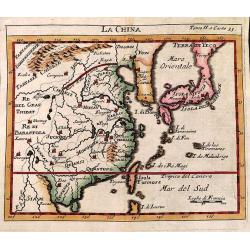
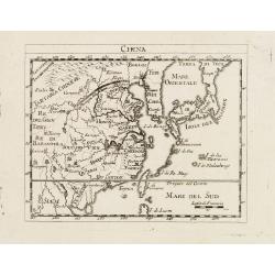
La China.
Smaller format map of China based on the work of De L'Isle.The map is of interest for the use of Sea of Japan / East Sea, the sea between Korea and Japan, here called &qu...
Date: ca. 1743
Selling price: ????
Please login to see price!
Sold in 2012
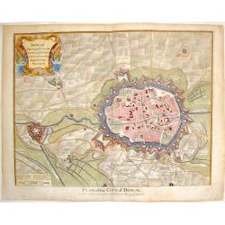
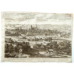
Doway, A Strong City in the Earldom of Flanders. - Plan of the City of Doway.
Interesting copper engraved plan of the Fortification of Doway. Fancy Rococco cartouche. Nicholas Tindal (1687-1774)/ Paul de Rapin (1661-1725) was a Frenchman responsi...
Date: London, 1743
Selling price: ????
Please login to see price!
Sold in 2016

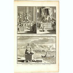
Toranga divinité du Japon/ La Pagode de Toranga/ Prédicateur Japonais.
Three scenes on one page showing scenes on the square of a Pagoda, in Japan. Fine copper engraving by Bernard Picart and taken from Bernard Picart's famous Céréonies et...
Date: Amsterdam, 1743
Selling price: ????
Please login to see price!
Sold in 2021

Pagode de Canon/ Canon divinité du Japon/ Autre représentation de Canon/ Xantai divinité du Japon.
Four scenes on one page showing religious scenes, in Japan. Fine copper engraving by Bernard Picart and taken from Bernard Picart's famous Céréonies et costumes religie...
Date: Amsterdam, 1743
Selling price: ????
Please login to see price!
Sold in 2021
Tiedebaik divinité du Japon. / Amida divinité du Japon. / Autre représentation d'Amida, et diverses manieres de noyer dans son honneur.
Three scenes on one page showing religious scenes, in Japan. Fine copper engraving by Bernard Picart and taken from Bernard Picart's famous Céréonies et costumes religi...
Date: Amsterdam, 1743
Selling price: ????
Please login to see price!
Sold in 2021

Idole Xekia. / Autre représentation de Xekia.
Two scenes on one page showing religious scenes in Japan. Fine copper engraving by Bernard Picart and taken from Bernard Picart's famous Céréonies et costumes religieus...
Date: Amsterdam, 1743
Selling price: ????
Please login to see price!
Sold in 2021

Facciata della Chiesa Cattedrale di S. Pietro in Jorck.
Facade of the Cathedral Church of St. Peter in York. Hand colored copper engraving published by York in 1743 and engraved by Salmon.
Date: Gavirate, 1743
Selling price: ????
Please login to see price!
Sold in 2018
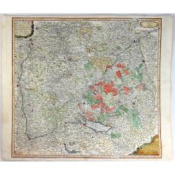
Circuli Sveviae Mappa ex Subsidijs Mechalanis...
A map of Württemberg and the Swabish principality in Austria. On the left side is Strasberg, on the top is Heidleberg, on the right is Neuberg and on the bottom is Zuric...
Date: Nuremberg, 1743
Selling price: ????
Please login to see price!
Sold in 2016
Circuli Sueviae Mappa...
A detailed regional map of Germany and Austria, extending from the Rhine to the Lech Rivers, with course of the Donau River in the middle.Extends to Basel, Zurich, Consta...
Date: Nuremberg, 1743
Selling price: ????
Please login to see price!
Sold in 2016
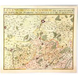
Les Environs de Cambray, de Crevecoeur, de Bapaume, De Perrone, Du Catelet de St. Quentin
A map showing the north part of France near Cambray on the Scheldt River, by Nicolas de Fer in Paris in 1724. It was published by Chez Le Benard.Nicolas de Fer (1646-172)...
Date: Paris, 1743
Selling price: ????
Please login to see price!
Sold in 2019
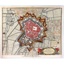
Plan of Bethune
An old detailed antique battle plan of Bethune in France showing the bastions, rivers, canals and fortifications outside the city and the shelling during the Spanish Succ...
Date: London, 1743
Selling price: ????
Please login to see price!
Sold in 2016
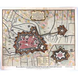
Plan of the City of Aire and of Fort St. Francis with a View of St. Venant
A very strong City and Castle in the Low Countries, in the Earldom of Artois, taken by the Allies in 1710, but restored to the French by the Treaty of Utrecht. The map is...
Date: London, 1743
Selling price: ????
Please login to see price!
Sold in 2016
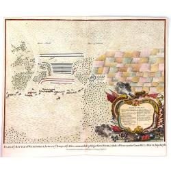
Plan of the Battle of Wynendal, Between the Troops of the Allies Commanded by Major Gen. Webb
A copper engraved battle plan between Major General Webb and Count de la Motte, with actual miniature pictures of the troupes. With a very fancy rococo cartouche, with ca...
Date: Paris, 1743
Selling price: ????
Please login to see price!
Sold in 2016
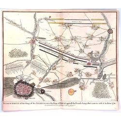
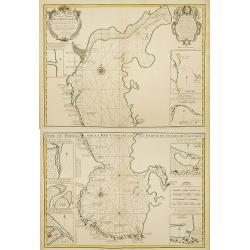
Entrenchment of the Army of the Allies to cover the Siege of Douay ...
An antique old battle plan of the fortified Town of Douai, France during the War of Spanish Succession (1701-1713) with surrounded area. The map shows the preparation of ...
Date: London, 1743
Selling price: ????
Please login to see price!
Sold in 2016
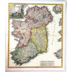
Irlanda.
A beautiful map of Ireland, finely engraved in Italy by Giambatista Albrizzi, with detailed topographical and political information.The map shows the four provinces of Ir...
Date: Venice, 1743
Selling price: ????
Please login to see price!
Sold in 2019
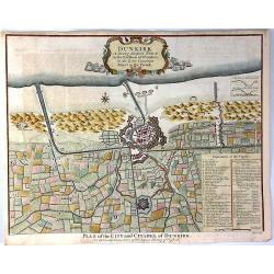
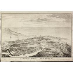
Dunkirk, A Strong Seaport Town in the Earldom of Flanders
A striking view of the walled city of Dunkirk with its extensive fortifications and surrounding countryside.A key at bottom left lists 40 important sites which are labele...
Date: London, 1743
Selling price: ????
Please login to see price!
Sold in 2020
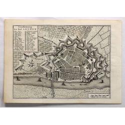
Grondtekening der Stad Arnhem.
A beautifully detailed plan of the fortress and surrounding area of Arnhem. A key identifies many gates, bastions and places. Arnhem is a city situated in the eastern par...
Date: Amsterdam, 1743
Selling price: ????
Please login to see price!
Sold in 2017
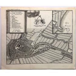
Grondtekening der Stad Schiedam.
A beautifully detailed plan of the fortress and surrounding area of Schiedam. A key identifies many gates, bastions and places.Schiedam is a city and municipality in the ...
Date: Amsterdam, 1743
Selling price: ????
Please login to see price!
Sold in 2018
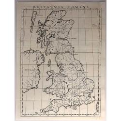
Britannia Romana.
Antique, minimalistic, copper engraved map, published in 1743 by John and Paul Knapton, London, for "The History of England" by Rapin de Thoyras.Translated by N...
Date: London, 1743
Selling price: ????
Please login to see price!
Sold in 2017
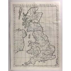
Britannia Romana.
An antique copper engraved map published in 1743 by John and Paul Knapton, London for "The History of England" by Rapin de Thoyras. Translated by Nicholas Tinda...
Date: London, 1743
Selling price: ????
Please login to see price!
Sold in 2017
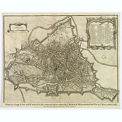
Ghent a large City and Castle in Flanders. . .
A very fine bird's-eye plan of the city and fortifications of Ghent and the surrounding countryside in Belgium. A decorative cartouche encloses a detailed key to the map ...
Date: London, 1743
Selling price: ????
Please login to see price!
Sold in 2019
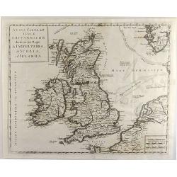
Nuova Carta dell' Isole Britanniche. . .
A rare map of the British Isles. It extends from southwestern Norway and the western coast of the Low Countries and northwestern France.
Date: Naples, 1743
Selling price: ????
Please login to see price!
Sold in 2019

L'EUROPE.
An elegant map of Europe with a large amount of topographical and settlement detail provided. It is based upon Haas' stereographic horizontal projection. A very large dec...
Date: Nuremberg, 1743
Selling price: ????
Please login to see price!
Sold in 2019
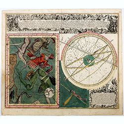
Cometa qui Anno Christi 1742, Apparuit, Ex Observationibus, a die 13 Marty usque ad 15 Aprilis, plusquam Vigesies. . .
Rare. This delightful engraving includes four distinct parts: Two cartouches in the first the title with the data relating to the appearance and the path of the comet in ...
Date: Augsburg, 1743
Selling price: ????
Please login to see price!
Sold in 2020
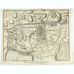
Plan of Turin as besieged in 1706. . .
An interesting copper engraved plan of the Fortification of Turin in Italy, with an attractive rococo bordered key. Nicholas Tindal (1687-1774) / Paul de Rapin (1661-1725...
Date: London, 1743
Selling price: ????
Please login to see price!
Sold in 2021
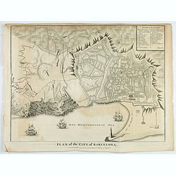
Plan of the city of Barcelona.
An interesting copper engraved plan of Barcelona, with ships before the shore, engraved by Basire. Lettered key in upper right corner. Nicholas Tindal (1687-1774) / Paul ...
Date: London, 1743
Selling price: ????
Please login to see price!
Sold in 2021
![Atlas général. [Composite atlas].](/uploads/cache/49062-250x250.jpg)
Atlas général. [Composite atlas].
ROBERT DE VAUGONDY, Gilles / SANSON, N. / JAILLOT, H. / BAILLIEU(L), Gaspard; ATLAS CONSISTING OF MOST OF THE EARLIEST PUBLISHED MAPS BY GILLES ROBERT DE VAUGONDY, 1720-1...
Date: Paris, ca.1743
Selling price: ????
Please login to see price!
Sold in 2024
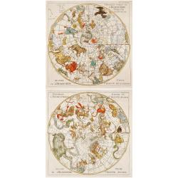
Premiere partie de l' Hemisphere Celeste Septentrional..
Two interesting sets of celestial charts presenting the northern and southern skies. The constellations are finely engraved with allegorical figures. Each hemisphere is s...
Date: Amsterdam 1743
Selling price: ????
Please login to see price!
Sold
Overblyfselen der tuinen, en groote waterbakken van Salomon.
Fine copper engraving showing the contemporary remains of the Gardens and water reservoirs of Salomon. Engraved by A.D.Putter and taken from Bernard Picart's famous Cér�...
Date: Amsterdam 1743
Selling price: ????
Please login to see price!
Sold
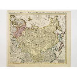
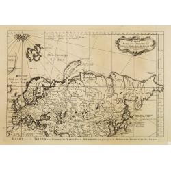
Kaert van Het geheele Russische Keizerryk..
Map of the whole Russian empire. Together with Major and Minor Tartary now enlarged with new discoveries in the year 1739 by captain Span(g)berg.Map extends from Scandina...
Date: Utrecht 1743
Selling price: ????
Please login to see price!
Sold
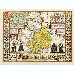
Cambridgshire?
Rare. From the Johan and Henry Overton's edition of John Speeds "Theatre of the Empire of Great Britain". Apart from 4 editions of the Atlas, published between ...
Date: London, 1710-1743
Selling price: ????
Please login to see price!
Sold
China.
Charming uncommon Italian map of China, Japan, Korea and Taiwan listed as Tayoun and I.di Formosa. The Great Wall is depicted prominently.
Date: Italy c.1743
Selling price: ????
Please login to see price!
Sold
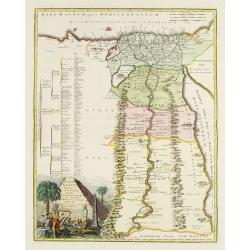
Veteris Aegypti Tabula ex variis auctoribus decerpta..
A very fine map centered on Egypt. Includes also a list of the provinces on the left side. Published by Joseph-Nicolas De l' Isle (or Delisle) (1688-1768), astronomer, ge...
Date: Paris 1743
Selling price: ????
Please login to see price!
Sold
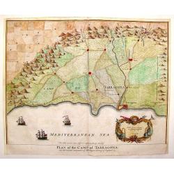
Plan of the Camp of Tarragona.
Copper engraved map of the Battle of Tarragona in Spain. Slendid cartouche with Neptune and two sea maonsters and with three detailed ships in the harbour. Paul de Rapin...
Date: London, 1743
Selling price: ????
Please login to see price!
Sold in 2014
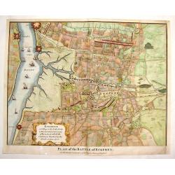
Plan of the Battle of Eckeren.
Detailed battle plan of the Battle of Eckeren. Belgium. Fancy Rococo cartouche and nine detailed ships in the harbour. Paul de Rapin (1661-1725) was a Frenchman responsi...
Date: London, 1743
Selling price: ????
Please login to see price!
Sold in 2014
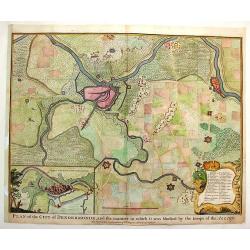
Plan of the City of Dendermonde.
Copper engraved city plan of Dendermonde showing how allied troops blocked it. Nice Rococo cartouche. Paul de Rapin (1661-1725) was a Frenchman responsible for publishing...
Date: London - 1743
Selling price: ????
Please login to see price!
Sold in 2015
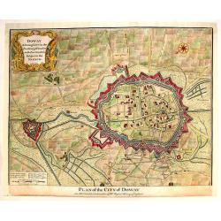
Doway, A Strong City in the Earldom of Flanders.
Copper engraved city plan of Douai from "History of England." Features the extensive fortifications and troop placements during the War of the Spanish Successio...
Date: London, 1743
Selling price: ????
Please login to see price!
Sold in 2015
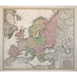
Europa Secundum Legitimas Projectionis Stereographicae Regulas et juxta recentissimas observationes ?
Johann Baptist Homann's well-engraved map of Europe. An ornate title cartouche with puti presenting gifts to a Queen.Johann Baptist Homann (1663-1724) was a German engrav...
Date: Nuremberg 1743
Selling price: ????
Please login to see price!
Sold in 2009
A Prospect of Carthagena, Taken from Madre de la Popa.
Very rare view of Cartagena de IndiasThis English copper engraved view of Cartagena in Colombia was drawn by an unidentified J. Norden and engraved by William Henry Toms,...
Date: London, 1743
Selling price: ????
Please login to see price!
Sold in 2010
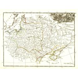
La Pologne.
Fine map of Poland with a battle scene cartouche upper right. From : "Théâtre Général de la Guerre en Europe".G.-L. Le Rouge, who was lieutenant in the regi...
Date: Paris, 1743
Selling price: ????
Please login to see price!
Sold in 2010
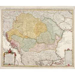
Hungariae..propriae, Croatiea, Dalmatiae, Bosniae..
Detailed map of Central Europe.
Date: Neurenberg 1744
Selling price: ????
Please login to see price!
Sold
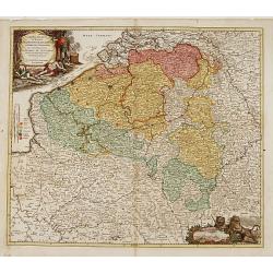
Arena Martis in Belgio qua provinciae X catholicae..
"Johann Baptist Homann's well-engraved map of Belgium, southern part of the Netherlands and Luxembourg. With two fine decorative title cartouche, one with miniature ...
Date: Neurenberg 1744
Selling price: ????
Please login to see price!
Sold
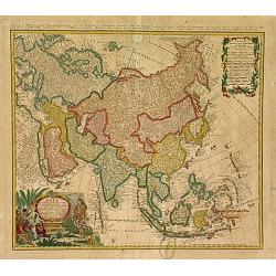
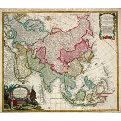
Asia secundum legitimas projectionis..
"A decorative map prepared by Prof. Johann Matthias Haas (1684-1742), who produced a number of continental and regional maps for the atlases issued by the firm of Ho...
Date: Nuremberg 1744
Selling price: ????
Please login to see price!
Sold
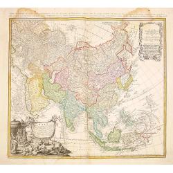
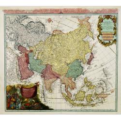
Asia Secundum Legitimas Projectionis..
Attractive 18th century map of the continent and the East Indies drawn by Matthias Haas. The extent of European knowledge of the region is vividly depicted with good deta...
Date: Nurnberg 1744
Selling price: ????
Please login to see price!
Sold
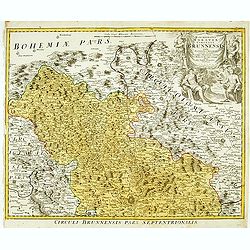
Marchionatus Moraviae circulus brunnensis..
Johann Baptist Homann's well-engraved map has a large decorative cartouche. Detailed map centered on Brunnensis, showing the main cities. Very decorative title cartouche ...
Date: Nuremberg, 1744
Selling price: ????
Please login to see price!
Sold in 2008
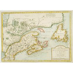
Carte de la partie Orientale de la nouvelle France ou du ..
Nicolas Bellin's landmark map of maritime Canada in a first appearance: Charlevoix's Histoire.. in 1744.Later he used the map as a basis for his equivalent maps of 1745 a...
Date: Paris 1744
Selling price: ????
Please login to see price!
Sold
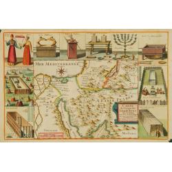
Carte du Voïage des Israëlites dans de desert..
Lièbaux's map of the Wandering of the Children Israel. With the route taken by the Israelites from Egypt to Canaan.
Date: Paris 1744
Selling price: ????
Please login to see price!
Sold
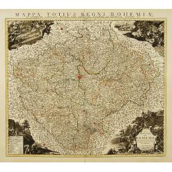
Le Royaume de Boheme Divisée en ses douze Cercles.
Highly detailed copper-engraved map of Bohemia centered on Prague. Ornated with decorative cartouches at the 4 corners of the map representing respectively a view of Prag...
Date: Amsterdam c. 1744
Selling price: ????
Please login to see price!
Sold
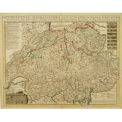
Nova Helvetiae Foederatarumque..
General map of Switzerland divided into cantons with cartouches showing the coats of arms of 24 Cantons and additional notes. Relief shown pictorially.The map is from a D...
Date: Amsterdam c. 1744
Selling price: ????
Please login to see price!
Sold
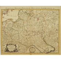
La Pologne dressee sur ce qu'en ont donne Starovolst, Beauplan, Hartnoch..
Large map of Poland, Lithuania, Belarus and part of Ukraine. The map is filled with detail and decorated with a title cartouche flanked by mythological figures. Latin tit...
Date: Amsterdam c. 1744
Selling price: ????
Please login to see price!
Sold
![[2 maps] Theatre de la Guerre Dans la Petite Tartarie, La Crimee, la Mer Noire, &c.. [and] Seconde Partie de la Crimée.. (2 maps)](/uploads/cache/21474-250x250.jpg)
[2 maps] Theatre de la Guerre Dans la Petite Tartarie, La Crimee, la Mer Noire, &c.. [and] Seconde Partie de la Crimée.. (2 maps)
Set of 2 copper engraved maps from the observations of Guillaume Delisle focusing on the Black Sea with wonderful detail of the surrounding regions. Includes Constantinop...
Date: Amsterdam c. 1744
Selling price: ????
Please login to see price!
Sold
Carte Marine de la Mer Caspiene levée Suivant les Ordres.. (2 maps)
Accurate map of the Caspian. Dutch edition based upon earlier maps by De L'Isle who re-drew Verden's original map. Embellished with 2 cartouches and 8 insets.The map is f...
Date: Amsterdam c. 1744
Selling price: ????
Please login to see price!
Sold
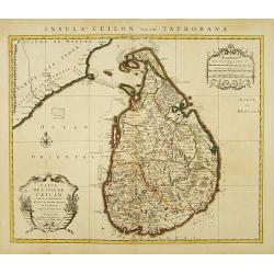
Carte de L'Isle de Ceylan Dressée sur les Observations de..
Large, detailed map of Ceylon. Embellished with 2 decorative cartouches. Latin title Insula Ceilon olim Taprobana on top.The map is from a Dutch edition of De L'Isle's wo...
Date: Amsterdam, c. 1744
Selling price: ????
Please login to see price!
Sold in 2009
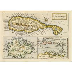
The Island of St. Christophers / Antego Island / Part of y Islands of America &c..
Composite map of St. Christopher, Antigua, and part of the West Indies (from eastern Cuba to northern South America). The St. Kitts and Antigua maps include many place na...
Date: London 1744
Selling price: ????
Please login to see price!
Sold
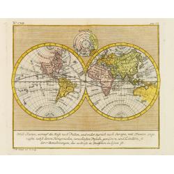
Welt Charten, worauf die Reife nach Indien..
Rare world map in double hemisphere, from Allerneuster geographisch- und topographischer Schau-Platz von Africa und Ost-Indien. Interesting depiction of California.
Date: Germany 1744
Selling price: ????
Please login to see price!
Sold
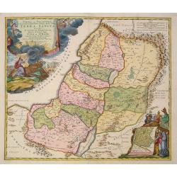
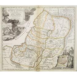
Judaea seu Palaestina .. Terra Sancta. . .
Johann Baptist Homann's well-engraved map has two large decorative cartouches. Upper left Moses receiving the Tables. Lower right Moses and Aaron pointing at a map showin...
Date: Nuremberg, 1744
Selling price: ????
Please login to see price!
Sold in 2021
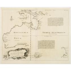
A Complete Map of the Southern Continent Survey'd by Capt. Abel Tasman & depicted by Order of the East Indian Cmpany in Holland In The Stadt House at Amsterdam.
The first large-scale English map devoted to Tasman's discoveries on both his voyages. Noted on the map are the promises of riches that are certain to be discovered by vi...
Date: London, 1744
Selling price: ????
Please login to see price!
Sold
Carte pour les Voyages de Rubruquis, Marco Polo Jen-Kin-son & ca.
Dutch version of the map representing Europe and northern Asia, showing the routes of explorers looking east. These include Marco Polo's trip to China, Jenkinson's route ...
Date: Paris, 1744
Selling price: ????
Please login to see price!
Sold in 2008
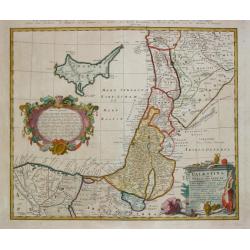
Palestina seu Terra olim Sancta.
Homann Heirs (of Johann Baptist and Johann Christof) published: Grosser Atlas, 1731, 1737. Geogr. Maior, 1759, Atlas Homannianus, 1762.A map of Palestine and the Libanon ...
Date: Nürnberg, 1744
Selling price: ????
Please login to see price!
Sold
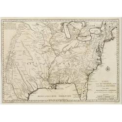
Karte von Luisiana, dem Laufe des Mississipi und den benachb
A rare German text edition of de l'Isles map of the Gulf region of the Mississippi. The European colonies and possessions along the Atlantic and Gulf coasts share importa...
Date: Paris 1744
Selling price: ????
Please login to see price!
Sold
Asia.
Homann Heirs (of Johann Baptist and Johann Christof) published: Grosser Atlas, 1731, 1737. Geogr. Maior, 1759, Atlas Homannianus, 1762.August Gottlieb Boehme?s map of Asi...
Date: Nürnberg, 1744
Selling price: ????
Please login to see price!
Sold in 2013
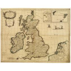
Les Isles Britanniques ou les Royaumes d'Angleterre, d'Écosse et d'Irlande. Divisées par Provinces..
Map of the British Isles with inset maps of the Channel Islands and the Faroe, Orkney and Shetland Islands.Embellished with fighting vessels and an ornamental title carto...
Date: Paris 1744
Selling price: ????
Please login to see price!
Sold
Asia Secundum..
The map is of interest for the use of East Sea, the sea between Korea and Japan, here called "Mere Orientale Minus Corea".The cartouches are painted in strong a...
Date: Nuremberg, ca. 1744
Selling price: ????
Please login to see price!
Sold in 2015
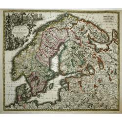
Synopsis Plagae Septentrionalis Sueciae Daniae et Norwegiae Regn.
Large decorative map of Scandinavia filled with topographical and political information. Attractive title cartouche with figures and a coat of arms.
Date: Augsburg, 1744
Selling price: ????
Please login to see price!
Sold
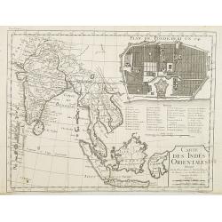
Carte des Indes orientales dressee sur les observations de l'Academie Royale des Sciences, et sur les memoires de la Compagnie des Indes.
Uncommon map of South East Asia, with in upper right corner inset "Plan de Pondicherry en 1741", with a key A-S, 1-21. Engraved by F.Desbruslins. Scale ca. 1:25...
Date: Paris, Jean Desaint & Charles Saillant, 1744
Selling price: ????
Please login to see price!
Sold in 2008
Iudaea seu Palaestina .. Terra Sancta. . .
Johann Baptist Homann's well-engraved map has two large decorative cartouches. Upper left Moses receiving the Tables. Lower right Moses and Aaron pointing at a map showin...
Date: Nuremberg, 1744
Selling price: ????
Please login to see price!
Sold in 2011
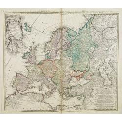
Europa Secundum Legitimas Projectionis Stereographicae Regulas et juxta recentissimas observationes. . .
Johann Baptist Homann's well-engraved map of Europe has a large decorative cartouche. Johann Baptist Homann (1663-1724) was a German engraver and publisher, who establish...
Date: Nuremberg, 1744
Selling price: ????
Please login to see price!
Sold in 2011
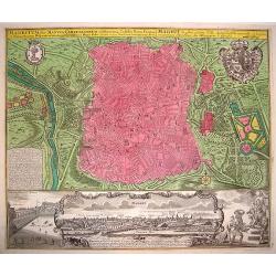
Madritum sive Mantua Carpetanorum celeberrima Castiliae Novae Civitas
A crisply engraved, superbly detailed plan of Madrid. The royal and city arms grace the larger portion of the plate. The lower section provides a prospect of the city, wi...
Date: Nuremberg, ca. 1744
Selling price: ????
Please login to see price!
Sold in 2008
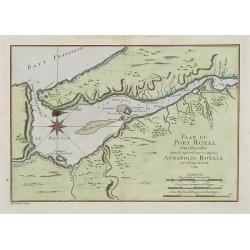
Plan du Port Royal dans l'Acadie, Appelé Aujourd' par les Anglois Annapolis Royal.
This chart shows the territories of Port Royal in Acadia.Depths shown by soundings.From Bellin's Histoire et Description Generale de la Nouvelle France Charlevoix.Tome I ...
Date: Paris, 1744
Selling price: ????
Please login to see price!
Sold
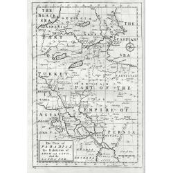
The Place Of Paradise The Habitation Of Adam And Seth And The Land Of Nod.
Mainly covers much of Georgia, Armenia, Turkey, Iran and Iraq and furthermore pointing out sites associated with Adams sons and charting the course that Noah's Ark took. ...
Date: London, 1744
Selling price: ????
Please login to see price!
Sold in 2017
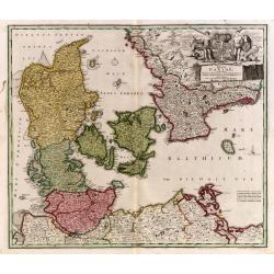
Regni Daniae, in quo sunt Ducatus Holsatia..
Johann Baptist Homann's well-engraved map of Denmark, Schleswig-Holstein and Mecklenburg in Germany. With fine decorative title cartouche.Johann Baptist Homann (1663-1724...
Date: Neurenberg 1744
Selling price: ????
Please login to see price!
Sold in 2009
Dantzick Ville de Pologne dans la Prusse Royale.
A very RARE panoramic view of the town of Danzig in Poland.The plate is numbered in red pencil in upper right corner.Engraved by Pierre Aveline (Paris, c.1656 - 23 May 17...
Date: Paris, 1744
Selling price: ????
Please login to see price!
Sold in 2009
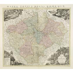
Le Royaume de Boheme Divisée en ses douze Cercles.
Highly detailed copper-engraved map of Bohemia centered on Prague. Ornated with decorative cartouches at the 4 corners of the map representing respectively a view of Prag...
Date: Amsterdam, c. 1744
Selling price: ????
Please login to see price!
Sold in 2009
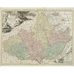
Carte Générale du Marquisat de Moravie Divisée en six Cercles dressée sur les mémoires les plus nouveaux.
Detailed copper-engraved map representing Moravia divided in districts. With decorative title cartouche and legend cartouche on upper left and lower right corners. Shows ...
Date: Amsterdam, c. 1744
Selling price: ????
Please login to see price!
Sold in 2009
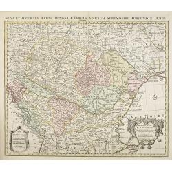
Le Royaume de Hongrie et des pays qui en dependoient autrefois..
Detailed copper-engraved map of Hungary with its neighboring countries. The map is also improved after the observations by Marsigli, who published an important descriptio...
Date: Amsterdam, c. 1744
Selling price: ????
Please login to see price!
Sold in 2012
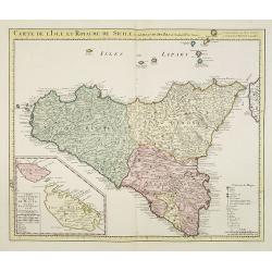
Carte de l'Isle et Royaume de Sicile Par Guillaume del 'Isle . . .
Detailed and rare issue of this map of Sicily prepared by de L'Isle. Beautiful rendering of Mt. Etna. An inset map of the islands of Malta and Gozzo, " Carte particu...
Date: Amsterdam c. 1744
Selling price: ????
Please login to see price!
Sold in 2015
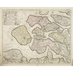
Nieuwe kaart van de graafschap Zeeland. . .
Rare map of the Province of Zeeland, with its many islands and peninsulas. Major cities, small villages, and some of the natural features are named. Published by Reinier ...
Date: Amsterdam, c. 1744
Selling price: ????
Please login to see price!
Sold in 2009
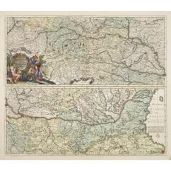
Exactissima Totius DANUBII FLUVII. Tabula et . . .
Two maps on one sheet, showing the course of the River Donau. Originally published by Danckerts. The upper part has a nice originally colored title cartouche and depicts ...
Date: Amsterdam, c. 1744
Selling price: ????
Please login to see price!
Sold in 2009
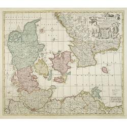
Dania Regnum In quo sunt Ducatus Holsatia et Slesvicum Iutia, et Insule, dictae Danicae. . .
An attractive map centered on Denmark and including southern tip of Sweden. Very ornamented title cartouche in the upper right-hand corner.Originally published by Frederi...
Date: Amsterdam c. 1744
Selling price: ????
Please login to see price!
Sold in 2015
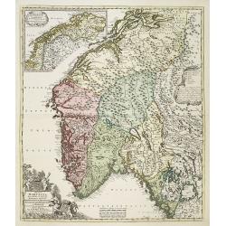
Regni Norvegiae Nova Tabula in Quinque Praefecturas Generalis. Aggerhusiensem, Bergensem, Nidrosiensem, Warhusiae et
A re-issue by Covens and Mortier of the copperplate by Frederick de Wit. The copperplate lines were carefully redone and their address added to the scales in lower center...
Date: Amsterdam c. 1744
Selling price: ????
Please login to see price!
Sold in 2009