Browse Listings
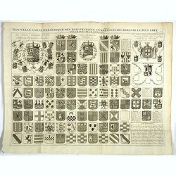
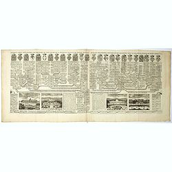
Nouvelle carte heraldique des rois d'Espagne . . .
Decorative sheet with coats of arms of Spanish and Portuguese Kings and noble families.From Chatelain's monumental 7 volume "Atlas Historique".Henri Abraham Cha...
Date: Amsterdam, 1720
Selling price: ????
Please login to see price!
Sold in 2018
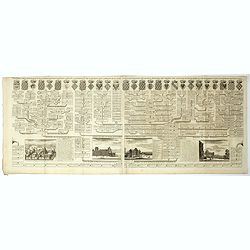
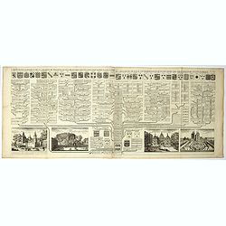
![Nouvelle carte pour introduire à la géographie et à la généalogie des rois d'Angleterre et d'Ecosse. . .[and] Carte des Prerogatives des Rois et de la Noblesse d'Angleterre. . .[and] Representation du Parlement d'Angleterre. . .](/uploads/cache/39121-250x250.jpg)
Nouvelle carte pour introduire à la géographie et à la généalogie des rois d'Angleterre et d'Ecosse. . .[and] Carte des Prerogatives des Rois et de la Noblesse d'Angleterre. . .[and] Representation du Parlement d'Angleterre. . .
Interesting sheet with a map of the family tree for the Royal Families of Great Britain, Scotland, and France, with descriptive French text, from Chatelain's monumental 7...
Date: Amsterdam, 1720
Selling price: ????
Please login to see price!
Sold in 2017
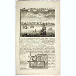
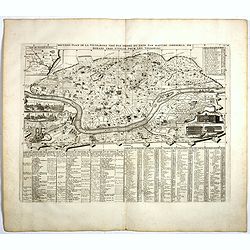
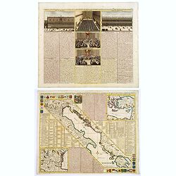
Vue et description de Surate et de Batavia.
In top a panoramic view of Surat, a port city in India previously known as Suryapur, with Dutch ships in the foreground. In bottom a plan of Jakarta (Batavia, 100 x 125mm...
Date: Amsterdam, 1720
Selling price: ????
Please login to see price!
Sold in 2022
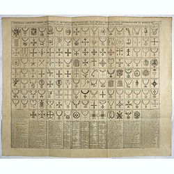
Nouvelle carte des ordres militaires ou de la chevalerie institués par divers princes pour récompenser le mérite ou la vertu par reconnaissance de quelque signalée victoire.
Interesting sheet with an illustration of all the medals awarded to the Knights, with descriptive French text, from Chatelain's monumental 7 volume "Atlas Historique...
Date: Amsterdam, 1720
Selling price: ????
Please login to see price!
Sold in 2018
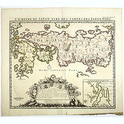
L'Empire du Japon, tiré des cartes des Japonnois.
A good impression of this decorative map of Japan based on Reland's map of 1715, one of the earliest to use both Latin names and Japanese characters. With inset of the ba...
Date: Amsterdam, 1720
Selling price: ????
Please login to see price!
Sold in 2017
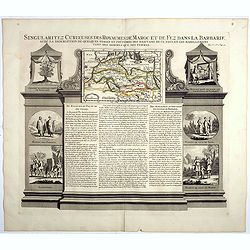
Singularitez Curieuses des Royaumes de Maroc et de Fez dans la Barbarie . . .
In the top a map of the Barbary Coast entitled La Barbarie. The text in the center of the sheet describes the Kingdoms of Morocco and Fez. The panel is bordered with thei...
Date: Amsterdam, 1720
Selling price: ????
Please login to see price!
Sold in 2023
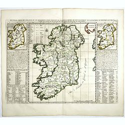
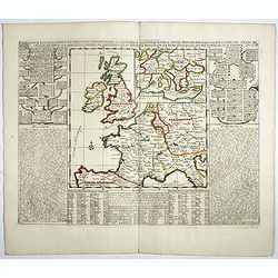
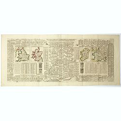
Nouvelle carte de l'Irlande, où on remarque l'Etat présente de cette isle . . .
Finely engraved map of Ireland, with two smaller maps of Ireland showing Ancient Ireland and an ecclesiastical map of modern Ireland. From Chatelain's monumental 7 volume...
Date: Amsterdam, 1720
Selling price: ????
Please login to see price!
Sold in 2017
Carte generale des differentes assemblees, ou conseils, des cantons Suisses, et l'ordre de leur gouvernement.
Decorative engraving showing 4 scenes of the various assemblies, or councils, of the Swiss cantons. From Chatelain's monumental 7 volume "Atlas Historique".Henr...
Date: Amsterdam, 1720
Selling price: ????
Please login to see price!
Sold in 2021
(Ichan Darsiac / Ferroy Sier / Pompe & Cérémonie de la marche du grand Mogol)
From Chatelain's monumental 7 volume "Atlas Historique".Henri Abraham Chatelain (1684 – 1743) was a Huguenot pastor of Parisian origins. He lived consecutivel...
Date: Amsterdam, 1720
Selling price: ????
Please login to see price!
Sold in 2018
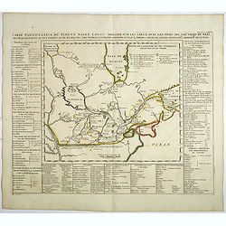
Carte particuliere du fleuve Saint Louis dressee sur les lieux avec les noms des sauvages du pais . . .
Map of the Great Lakes region, including the Northern reaches of the Mississippi, Hudson's Bay, and the Gulf of the St-Lawrence. Chatelain’s map is derived from Baron L...
Date: Amsterdam, 1720
Selling price: ????
Please login to see price!
Sold in 2019
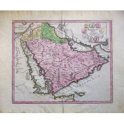
Arabiae Veteris Typus.
An attractive map of the ancient Arabian Peninsular, with a colored pictorial title cartouche.
Date: Nuremberg, 1720
Selling price: ????
Please login to see price!
Sold in 2018
Gouvernement des etats des sept provinces Unies. . .
Print showing the infrastructure of the Dutch government, including the government of the separate provinces and the government of the state. The plate is adorned with a ...
Date: Amsterdam, ca. 1720
Selling price: ????
Please login to see price!
Sold in 2017
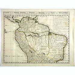
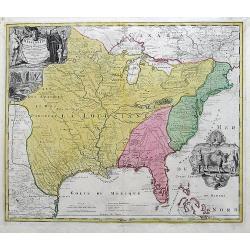
Carte de la Terre Ferme, du Perou, du Bresil, et du Pays des Amazones. . .
Handsome map of the northern part of South America based on the cartography of Guillaume Delisle.It is filled with place names and notations speculating about the Indian ...
Date: Amsterdam, 1720
Selling price: ????
Please login to see price!
Sold in 2017
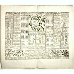
Cronologie Historique des Rois & des différens Etats de l'Ancienne Grèce . . .
Showing in top a map of ancient Greece (130 x 115mm.) with vignette views of the City States of Athens, Thebes and Corinth. The surrounding text details the history of Gr...
Date: Amsterdam, 1720
Selling price: ????
Please login to see price!
Sold in 2022
Carte pour l'itelligence de l'histoire dAngleterre où on remarque les conquètes de cette monarchie dans la plupart des états de l'europe, les droits sur lesquels sont fondées ses prétentions sur la monarchie française ou sur divers états...
Two maps on one sheet surrounded by historical and genealogical information to the history, chronology, ancient and modern geography, genealogy of the royal houses of Eur...
Date: Amsterdam, 1720
Selling price: ????
Please login to see price!
Sold in 2019
Carte des prérogatives des rois et de la noblesse d'Angleterre . . .
Extracted from the historical atlas: introduction to the history, chronology, ancient and modern geography, genealogy of the royal houses of Europe with descriptive Frenc...
Date: Amsterdam, 1720
Selling price: ????
Please login to see price!
Sold in 2023
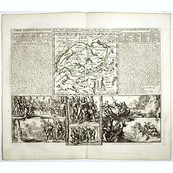
Carte ancienne de la Suisse avec des remarques . . .
An engraved text sheet with in top a map of Switzerland (18T x 190mm.) The sheet pays particular attention to the formation of the Swiss state and to the legend of the Sw...
Date: Amsterdam, 1720
Selling price: ????
Please login to see price!
Sold in 2020
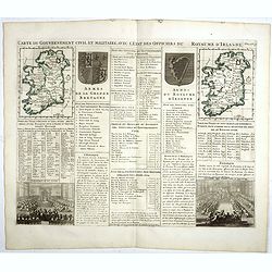
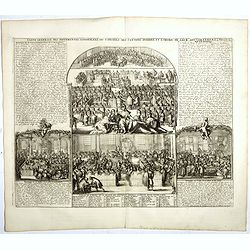
Carte du gouvernement civil et militaire avec l'Etat des Officiers du Royaume d'Irlande . . .
Engraved text sheet with two maps of Ireland (140 x 105mm. each), coats of arms of Ireland and England and a views of Irish Parliament and the House of Commons.Henri Abra...
Date: Amsterdam, 1720
Selling price: ????
Please login to see price!
Sold in 2022
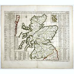
Nouvelle carte d'Ecosse . . .
Decorative map of Scotland with index tables giving details of the nobility, geographical divisions and notable settlements down both sides.Henri Abraham Chatelain (1684 ...
Date: Amsterdam, 1720
Selling price: ????
Please login to see price!
Sold in 2020
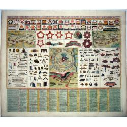
Carte generale du gouvernement militaire de France . . .
Engraved text sheet with numerous illustrations giving military statements of naval and terrestrial forces in France, particularly the state of the artillery and the nava...
Date: Amsterdam, 1720
Selling price: ????
Please login to see price!
Sold in 2019
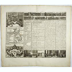
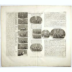
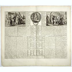
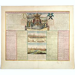
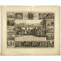
L'idée geneale du conclave de l'exaltation des papes, de leur pompe funebre et des differentes juridictions de la cour de Rome.
A fascinating decorative chart showing the assemblies in the Vatican, a view of St Peters, six interior views, a plan of the Vatican and military and papal musters. Henri...
Date: Amsterdam, 1720
Selling price: ????
Please login to see price!
Sold in 2018
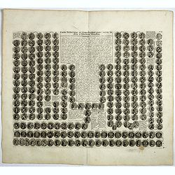
Carte historique et cronologique pour servir de suite à l' Histoire Romaine.
Interesting sheet with a small portraits of the Roman Emperors. Henri Abraham Chatelain (1684 – 1743) was a Huguenot pastor of Parisian origins. He lived consecutively ...
Date: Amsterdam, 1720
Selling price: ????
Please login to see price!
Sold in 2017
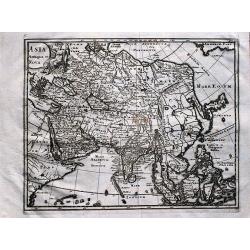
Asia antiqua et nova.
Interesting map of Asia from a German edition of Philipp Clüver's famous Introductionis in Universam geographicam, first published in Leiden in 1624. Philipp Clüver (15...
Date: Wolfenbüttel, ca 1720
Selling price: ????
Please login to see price!
Sold in 2019
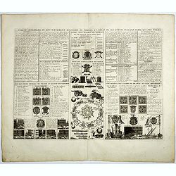
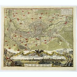
Carte des Ordres de Chevalerie des sa Majesté Czarienne, ses Titres, l' Etat de sa Noblesse, Profil de son Palais et la vue de Moscow.
View of Moscow, the Czar's Palace and a scene with the Czar holding court, from Chatelain's monumental Atlas HistoriqueHenri Abraham Chatelain (1684 – 1743) was a Hugue...
Date: Amsterdam, 1720
Selling price: ????
Please login to see price!
Sold in 2017
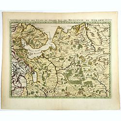
Nouvelle Carte des Etats du Grand Duc de Moscovie en Europe. Partie Sertentrionale.
Northern part of European Russia. Zacharie Chatelain (d.1723) was the father of Henri Abraham (1684-1743) and Zacharie Junior (1690-1754).They worked as a partnership pub...
Date: Amsterdam, ca. 1720
Selling price: ????
Please login to see price!
Sold in 2017
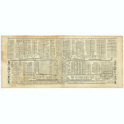
Nouvelle carte généalogique des branches du coté gauche de la maison des Valois ...
The family tree of the house of Valois issued from the 'third race' (Capetian dynasty), including the other houses issued from it or associated to it through marriage (su...
Date: Amsterdam, ca. 1720
Selling price: ????
Please login to see price!
Sold in 2022
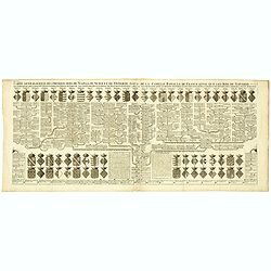
Nouvelle carte généalogique des familles Roiales de France . . .
Family tree of the French royal families issued from the 'first race' (Pharamond & the Merovingian Kings) and the 'second race' (the Carolingian Kings), until the adv...
Date: Amsterdam, ca. 1720
Selling price: ????
Please login to see price!
Sold in 2022
Carte généalogique des branches naturelles ou du coté gauche de la Maison Bourbon . . .
Interesting sheet with an impressive engraving ornamented with numerous vignettes representing French castles of Meudon, Versailles, St. Germain en Laye and Fontaine Blea...
Date: Amsterdam, ca. 1720
Selling price: ????
Please login to see price!
Sold in 2018
![[Title page] Atlas Historique ou nouvelle introduction à l'Histoire, à la Chronologie & à la Géographie Ancienne & Moderne . . . (Tome VII & Dernier)](/uploads/cache/39001-250x250.jpg)
[Title page] Atlas Historique ou nouvelle introduction à l'Histoire, à la Chronologie & à la Géographie Ancienne & Moderne . . . (Tome VII & Dernier)
Title page from Chatelain's monumental 7 volume Atlas Historique, Tome VII & Dernier. With charming engraved device "Ubertas ex foedere et pace" (82x110mm.)...
Date: Amsterdam, 1720
Selling price: ????
Please login to see price!
Sold in 2017
Nouvelle carte pour introduire à la géographie et à la généalogie des rois d'Angleterre et d'Ecosse avec diverses remarques pour le secours de la chronologie et de l'Histoire.
Interesting sheet with a map of the family tree for the Royal Families of Great Britain, Scotland, and France, with descriptive French text, from Chatelain's monumental 7...
Date: Amsterdam, 1720
Selling price: ????
Please login to see price!
Sold in 2017
Carte genealogique de la maison des Wassenaar . . .
A magnificent large copper engraved chart, featuring the genealogy of the House of Wassenaar in Holland. There are four fine topographical engravings, and 41 coats of arm...
Date: Amsterdam, 1720
Selling price: ????
Please login to see price!
Sold in 2017
Opkomts, midden, en geen eynde van den doortrapte Jan Lauw.
Print published in : Het groote tafereel der dwaasheid : vertoonende de opkomst, voortgang en ondergang der actie, bubbel en windnegotie, in Vrankryk, Engeland, en de Ned...
Date: Amsterdam, 1720
Selling price: ????
Please login to see price!
Sold in 2017

Vue et description de la Ville de Meaco Capitale du Japon. . .
Top part of the print shows the town of Meaco (Kyoto) at that time the capital of Japan, with a coach and horses in the foreground. Other parts show among other things th...
Date: Amsterdam, 1720
Selling price: ????
Please login to see price!
Sold in 2020
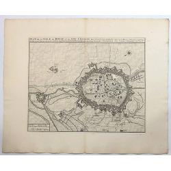
Plan de la Ville de Douay et du Fort D'Escarpe.
Striking engraved plan showing the city of Douay, drawn by Eugène Henry Fricx, a Brussels printer specialized in battles and sieges. Nice copy with large margins. The ma...
Date: Amsterdam, ca. 1720
Selling price: ????
Please login to see price!
Sold in 2019
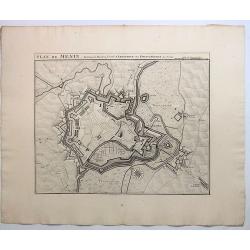
Plan de Menin, Fortresse de Flanders.
A striking map of the fortifications of Menen in West Flanders in Belgium. The map names buildings, ports, and other significant details, it also includes also roads, riv...
Date: Amsterdam, ca. 1720
Selling price: ????
Please login to see price!
Sold in 2019
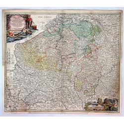
Brabantiae Ducatus.
A detailed map of the duchy of Brabant, now divided between the Netherlands and Belgium. Brussels and Antwerp are at left, Maestricht at right.On the lower right a cartou...
Date: Amsterdam, 1720
Selling price: ????
Please login to see price!
Sold in 2018
Nouveau Plan De La Ville De Rome Tire Pare Ordre Du Pape Par Mateo Gregoria De Romans Tres Utille Pour Les Voiageurs . . .
Fine plan of Rome with extensive key to principal buildings in town, with inset views of 10 major churches and structures, including St. Peters and the Vatican. Atlas His...
Date: Amsterdam, 1720
Selling price: ????
Please login to see price!
Sold in 2017
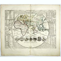
Plan de l'Histoire Universelle où l'on voit les quatre monarchies du Monde . . ..
Eastern hemisphere in a circle, into which is inset a smaller Western Hemisphere with the island of California. The map shows the extents of the Roman Empire and Alexande...
Date: Amsterdam, 1720
Selling price: ????
Please login to see price!
Sold in 2023
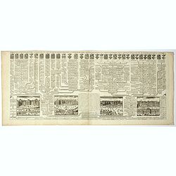
![[Four engravings showing People from India]](/uploads/cache/39592-250x250.jpg)
[Four engravings showing People from India]
Interesting sheet with four illustrations of different activities of people from India, from Chatelain's monumental 7 volume Atlas Historique. In upper right margin: 'Tom...
Date: Amsterdam, ca. 1720
Selling price: ????
Please login to see price!
Sold in 2017
Plan de St. Venant.
A very fine city plan of St. Venant, published by Covens & Mortier. It has a detailed legend on the right bottom corner.Saint-Venant is a commune in the Pas-de-Calais...
Date: Amsterdam, 1720
Selling price: ????
Please login to see price!
Sold in 2019
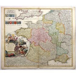
Totius Regni Galliae Sive Franciae Tabula...
An attractive map of France, showing fortified cities, towns, roads, rivers, mountains, etc. Stupendous decorative cartouche (one of the finest that I have seen) with old...
Date: Neurenberg, 1720
Selling price: ????
Please login to see price!
Sold in 2018
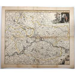
Comitatus Namurci TABULA IN Lucem.
A detailed map of Namur, Belgium centered on the Meuse River, published by the family of Frederick De Wit in about 1720.It includes a decorative cartouche featuring two b...
Date: Amsterdam, ca. 1720
Selling price: ????
Please login to see price!
Sold in 2018
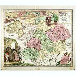
Nouvelle Carte de l'Alemagne avec des tables des branches de la noblesse..
Map of England including parts of the neighbouring countries with a key table to the towns on both sides.Zacharie Chatelain (d.1723) was the father of Henri Abraham (1684...
Date: Amsterdam, ca. 1720
Selling price: ????
Please login to see price!
Sold in 2017
Carte de Géographie des différents Etats de la République de Venise . . .
Interesting map of the Gulf of Venice with inset map of the surroundings of Venice and map of Turkey in upper right corner. Descriptive French text, from Chatelain's monu...
Date: Amsterdam, 1720
Selling price: ????
Please login to see price!
Sold in 2017
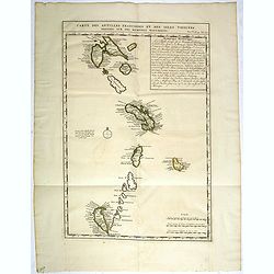
Carte des Antilles Françoises et des Isles voisines dressée sur des Mémoires Manuscrits.
Map of the West Indies Islands, with descriptive French text, from Chatelain's monumental 7 volume "Atlas Historique".Henri Abraham Chatelain (1684 – 1743) wa...
Date: Amsterdam, 1720
Selling price: ????
Please login to see price!
Sold in 2017
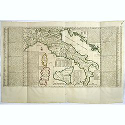
Nouvelle Carte De L'Etat Present De L'Italie Pour Parvenir par Une Methode Nouvelle A La Connoissance De La Geographie Et De L'Histoire.
Attractive and highly detailed map of Italy, colored by Kingdoms and showing Corsica, Sardinia and an inset of Sicily. Extensive text annotations on either side of this w...
Date: Amsterdam, 1720
Selling price: ????
Please login to see price!
Sold in 2021
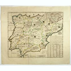
Carte Historique et Geographique des Royaumes d'Espagne et de Portugal..
Historical and geographical map of the kingdoms of Spain and Portugal divided according to their kingdoms and provinces. Including indexes, notes and an inset map of the ...
Date: Amsterdam, ca. 1720
Selling price: ????
Please login to see price!
Sold in 2018
![[ Bombario Auctionist ] Verhens-Beker van Fi ane of Vianen 2de Tooneel van de Geest van Esopus.](/uploads/cache/39815-250x250.jpg)
[ Bombario Auctionist ] Verhens-Beker van Fi ane of Vianen 2de Tooneel van de Geest van Esopus.
Decorative print of an Bombario Auctionist. A caricature in prose and verse satirizing the first truly international speculative crisis in the history of financial capita...
Date: Amsterdam, 1720
Selling price: ????
Please login to see price!
Sold in 2017
![[ Bombario Auctionist ] Oorsprong rondom bedekte Blaaskaak.](/uploads/cache/39816-250x250.jpg)
[ Bombario Auctionist ] Oorsprong rondom bedekte Blaaskaak.
Decorative print of an Bombario Auctionist. A caricature in prose and verse satirizing the first truly international speculative crisis in the history of financial capita...
Date: Amsterdam, 1720
Selling price: ????
Please login to see price!
Sold in 2017
![[ Bombario Auctionist ] Rector Magnificus van de Ongeactioneerde Litteratuur.](/uploads/cache/39817-250x250.jpg)
[ Bombario Auctionist ] Rector Magnificus van de Ongeactioneerde Litteratuur.
Decorative print of an Bombario Auctionist. A caricature in prose and verse satirizing the first truly international speculative crisis in the history of financial capita...
Date: Amsterdam, 1720
Selling price: ????
Please login to see price!
Sold in 2017
Lousiana by de Rivier Missisisppi.
A scarce little map of the Mississippi River Valley and western Great Lakes from the book “Het Groote Tafereel der Dwaasheid…” which accounts for the history of Joh...
Date: Amsterdam, 1720
Selling price: ????
Please login to see price!
Sold in 2019
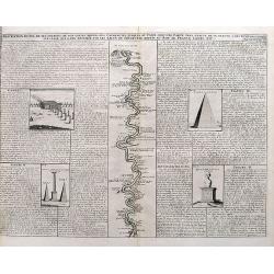
Description Du Nil de ses Sources, De Son Cours Depuis Les Cataractes Jusques Au Caire,...
A detailed map of the course of the Nile River, from the cataracts of the Nile at the south (top of the image) to Cairo and Giza. Shows one of the Pyramids (1400 feet tal...
Date: Amsterdam, ca. 1720
Selling price: ????
Please login to see price!
Sold in 2017

Description des Piramides d'Egypte...
An interesting sheet with four views of the Pyramids of Giza and one image of the Sphinx. With extensive descriptive text in French.
Date: Amsterdam, ca. 1720
Selling price: ????
Please login to see price!
Sold in 2017
Arena Martis in Belgio, Qua Provincie X Catholica...
A detailed map of Belgium and parts of Holland, France and Germany, showing the territories occupied by the French, English, Dutch, Bavarians, and Prussians with a color ...
Date: Neuremberg, 1720
Selling price: ????
Please login to see price!
Sold in 2017
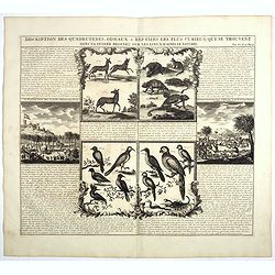
Description Des Quadrupedes, Oiseaux & Reptiles Les Plus Curieux Qui Se Trouvent Dans La Guinee . . .
Decorative copperplate engraving showing quadrupeds, reptiles and birds of Guinea, including a scene with elephants. From Chatelain's monumental 7 volume "Atlas Hist...
Date: Amsterdam, 1720
Selling price: ????
Please login to see price!
Sold in 2022
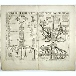
Chaine de l'histoire Sacrée / Chaine de l'Histore prophane.
From Chatelain's monumental 7 volume "Atlas Historique".Henri Abraham Chatelain (1684 – 1743) was a Huguenot pastor of Parisian origins. He lived consecutivel...
Date: Amsterdam, 1720
Selling price: ????
Please login to see price!
Sold in 2017
Carte du Gouvernement Civil et Politique...Venise / Carte de geographie des Differents Etats...Venise. . .
These impressive plates and maps are a wonderful example of Chatelain’s elegant skills. Both included in the 1720 edition of theAtlas Historique, published in Amsterdam...
Date: Amsterdam, 1720
Selling price: ????
Please login to see price!
Sold in 2017
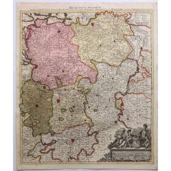
Germania Benedictina quae in illa sunt, Monasteria Ord. S. Benedicti monstrans. . .
Map showing the location of Benedictine abbeys inside central and southern Germany, Belgium, Switzerland, Belgium ,Austria and Czechoslovakia.. With an inset map of Polan...
Date: Nuremberg 1720
Selling price: ????
Please login to see price!
Sold in 2020
Prospect und Grundris der . . Stadt Nurnberg. . .
A scarce decorative plan of Nuremberg and environs, as seen from the south, with a fine panoramic view of the city, and a numbered key to the principal places within the ...
Date: Nuremberg, ca. 1720
Selling price: ????
Please login to see price!
Sold in 2020
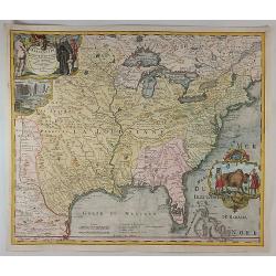
Amplissimae Regionis Mississipi Seu Provinciae Ludovicianae. . .
An iconic copperplate Map of the Mississippi Valley (United States, Louisiana, Texas, British Colonies) by Johann Baptiste Homann in Nuremberg in 1720. This map is often ...
Date: Nuremberg, 1720
Selling price: ????
Please login to see price!
Sold in 2017
Carte pour contribuer a indiquer la connoissance des premiers principes de fortifications.
A decorative military copperplate engraving showing various forms of defensive structures, as well as weapons for defending, and the tools for creating them. Also shown a...
Date: Amsterdam, ca 1720
Selling price: ????
Please login to see price!
Sold in 2021

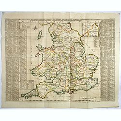
Britannia Depicta or Ogilby Improv'd.
The title page Britannia Depicta or Ogilby Improv'd plus the first two pages A Table of all the Maps.
Date: London 1720
Selling price: ????
Please login to see price!
Sold in 2017
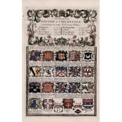
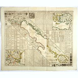
'Arms of the Colleges &c. in Cambridge' - The route from Oxford to Chichester.
A decorative antique strip map of the route from Oxford to Chichester.The route follows Oxford to Abingdon to East Istley to Newbury to King's Cleer.The 'Arms of the Coll...
Date: London, 1720
Selling price: ????
Please login to see price!
Sold in 2018
Amplissimae Regionis Mississipi... (The Bufflao Map).
Homann's important and highly decorative map of the Mississippi River Valley and the Southeast USA. Extends from the Great Lakes until the Bahamas, including Louisiana an...
Date: Nuremberg, c. 1720
Selling price: ????
Please login to see price!
Sold in 2017

Planisphaerium Coeleste.
This decorative, boldly-engraved double hemisphere map illustrates North and South Polar hemispheres, with smaller circular diagrams illustrating the theories of Tycho, L...
Date: Amsterdam, 1720
Selling price: ????
Please login to see price!
Sold in 2017
![[Two maps] Carte de Moscovie. . . / Partie Meridionale de Moscovie. . .](/uploads/cache/40596-250x250.jpg)
[Two maps] Carte de Moscovie. . . / Partie Meridionale de Moscovie. . .
[Two maps] This decorative two sheet map center's on Moscow (shown near the top of the lower sheet) and spans from the Sea of Azov in the south to the White Sea in the no...
Date: Amsterdam, 1720
Selling price: ????
Please login to see price!
Sold in 2018
![Comitatus Meursensis et annexarum dinastiarum. / Circulus Saxoniae Inferioris. . ./ Ducatus Slesvicensis. . . [Three maps]](/uploads/cache/40601-250x250.jpg)
Comitatus Meursensis et annexarum dinastiarum. / Circulus Saxoniae Inferioris. . ./ Ducatus Slesvicensis. . . [Three maps]
[Three maps] First map. Full title: Illustrissimo Celsissimoque Principii Guiljelmo Henrico D.G. Arausionum Principi Domino suo Clementissimo hanc Comitatus Meursensis et...
Date: Amsterdam, ca. 1710 / Nuremberg, 1720
Selling price: ????
Please login to see price!
Sold in 2018
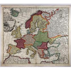
Europa Christiani Orbis Domina In Sua Imperia, Regna et Status. . .
An attractive Homann map of Europe. It is detailed, showing individual mountains and trees. The large (uncolored) title cartouche features "Europa"- surrounded ...
Date: Nuremberg, 1720
Selling price: ????
Please login to see price!
Sold in 2018

Portraits du Grand Seigneur et des Principaux Officiers de l'Empire Ottoman. . .
These four impressive engravings are a wonderful example of Chatelain’s elegant plates.Divided in 4 panels accompanied by detailed descriptions, are examples of costume...
Date: Amsterdam, ca. 1720
Selling price: ????
Please login to see price!
Sold in 2018

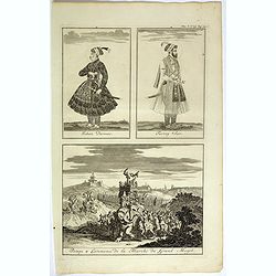
Sek ou Seich Omar, mort en 1493. Babar ou Baber ou Babour, mort en 1530. Amayum ou Houmayon, mort en 1552. Akebar ou Xa Aguebar, mort en 1605.
Striking and highly detailed copper engraved plate including 4 Indian Princes or Kings. From Chatelain's "Atlas Historique", 1732-1739. In upper right margin: '...
Date: Amsterdam, 1720
Selling price: ????
Please login to see price!
Sold in 2018
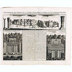
Description des Tombeaux & autres Monumens Anciens..
This impressive engraving is a wonderful example of Chatelain’s elegant plates.Ornamented with views representing burial monuments and mausoleums hewed out in the rock ...
Date: Amsterdam, ca. 1720
Selling price: ????
Please login to see price!
Sold in 2018

Habillemens des Dames.. Constantinople.. Serrail..
This beautiful copper-engraving containing 7 engravings of native female and 3 males of Istanbul.From Chatelain's Atlas Historique et Méthodique .
Date: Amsterdam, 1720
Selling price: ????
Please login to see price!
Sold in 2018
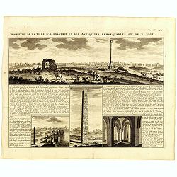
Description de la Ville d'Alexandrie et des Antiquites Remarquables qu'on y voit.
Panoramic view of the ancient Egyptian port city of Alexandria accompanied by insets of "Palais de Cleopatre" (the ruins of Cleopatra's palace), Obelisque d'Ale...
Date: Amsterdam, 1720
Selling price: ????
Please login to see price!
Sold in 2019
Gallia Cum Provinciis Infertis et Adsitis. . .
A copper engraved detailed map of Ancient France, divided into its provinces by Christopher Weigel in Nurnberg in 1719. Features a decorative cartouche with lions, soldie...
Date: Nurnberg, 1720
Selling price: ????
Please login to see price!
Sold in 2019
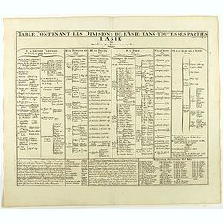
Table contenant les divisions de l'Asie dans toutes ses parties.
This folio sheet gives a breakdown of Asia into 6 principal regions.Henri Abraham Chatelain (1684 – 1743) was a Huguenot pastor of Parisian origins. He lived consecutiv...
Date: Amsterdam, 1720
Selling price: ????
Please login to see price!
Sold in 2021
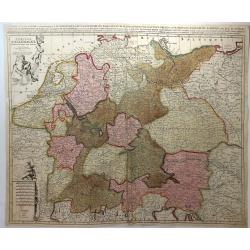
L'Empire D'Allemagne Divisee en Tous ses Estats.
A detailed map of Germany with figurative cartouche and scale of miles. Published by Pieter Schenk from the plate by Nicolas Sanson. The map in full original color with ...
Date: Paris, 1720
Selling price: ????
Please login to see price!
Sold in 2018
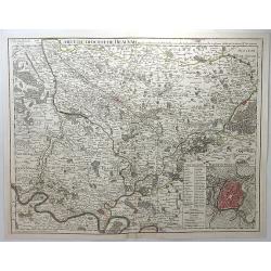
Carte du Diocese de Beauvais.
A detailed map of the vicinity of Beauvais, with an inset plan of the city of Beauvais. It is from Composite Atlas published in Amsterdam by Covens & Mortier in 1720....
Date: Amsterdam, 1720
Selling price: ????
Please login to see price!
Sold in 2018
Carte Genealogique des Divinitez du Paganisme, l' Incertitude de leur Origine avec des Instructions poour conduire a la Connoissance de la Fable et a l' Histoire Ancienne et Moderne avec Diverses Observations...
Showing a genealogy of the Pagan (Roman) deities, including details of their origins. Small insets show the ancient Roman Gods such as Venus, Apollon . . .Henri Abraham C...
Date: Amsterdam, 1720
Selling price: ????
Please login to see price!
Sold in 2018

Carte genealogique de la Maison de Bourbon . . .
Genealogical chart of the Bourbons, from Chatelain's monumental 7 volume "Atlas Historique". Henri Abraham Chatelain (1684 – 1743) was a Huguenot pastor of Pa...
Date: Amsterdam, 1720
Selling price: ????
Please login to see price!
Sold in 2018
Carte genealogique des premiers rois de Naples, de Sicile et de Hongrie . . .
Genealogical chart of kings of Naples, Sicily and Hungary, from Chatelain's monumental 7 volume "Atlas Historique". Henri Abraham Chatelain (1684 – 1743) was ...
Date: Amsterdam, 1720
Selling price: ????
Please login to see price!
Sold in 2018