Browse Listings
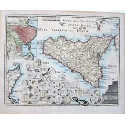
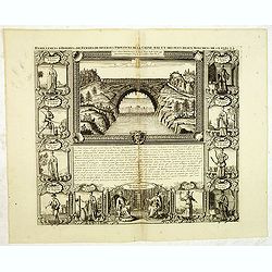
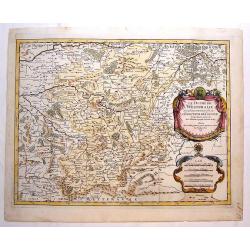
Sicilia antiqua quae et Trinacria dicta nummis Siculis illustrata.
A large, extremely decorative map of the island of Sicily, also showing parts of the Italian peninsula, Malta and a part of Tunisia. A large inset delineates the area of ...
Date: Nuremberg, 1720
Selling price: ????
Please login to see price!
Sold in 2022
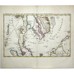
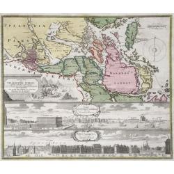
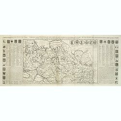
Le Royaume de Siam avec Les Royaumes Qui Luy sont Tributaries & c.
Part of Mortier's large Format multiple sheet Map of the Kingdom of Siam, Malaysian Peninsula, Singapore, Indonesia, etc. A gorgeous full color example of Pierre Mortier'...
Date: Amsterdam, ca 1720
Selling price: ????
Please login to see price!
Sold in 2021
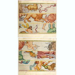
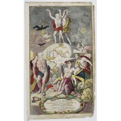
Zodiacus Stellatus Fixas Omnes Hactenus Cognitas, Ad Quas Lunae Appulsus Ullibi Terrarum Telescopio Poterunt, Complexus.
John Senex was one of the first English publishers to produce celestial charts. As noted by Kanas, In part through his collaboration with Halley, Senex produced a number ...
Date: London, 1720
Selling price: ????
Please login to see price!
Sold in 2020
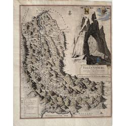
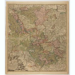
Le Pais de Toggenbourg, desine par Monsr. Jean Jacques Scheurchzer.
A detailed highly decorative map of Toggenbourg, in the Canton of St. Gallen in Switzerland. It presents two coat of arms and a large, fantastic mountain image. Rare.The ...
Date: Leiden, ca 1720
Selling price: ????
Please login to see price!
Sold in 2021
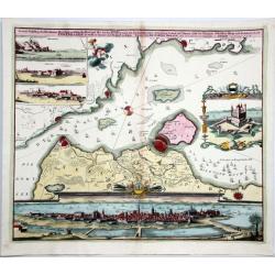
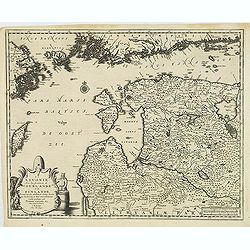
Accurate Vorstellung der Beruhmten Meer-Enge Zwischen der Nord und Ost See der Sund Genant, mit der herumligenden Gegend von Seeland und Schonen nebst der Koniglich-Danischen Haupt und Residentz Stadt Copenhagen...
Homann's map of the area between Copenhagen and Malmoe and the Sund Sound Showing the contiguous Danish & Swedish coastlines, centered on Copenhagen and Landscron. At...
Date: Nuremberg, ca. 1720
Selling price: ????
Please login to see price!
Sold in 2020
Atlas Novus Terrarum Orbis Imperia Regna et Status exactis Tabulis Geographice demonstrans . . .
A highly decorative title page, from Homann’s “Atlas Novus” a later plate engraved by Michael Rossler, published in Nuremberg circa 1720. It shows in the middle, th...
Date: Nuremberg, ca 1720
Selling price: ????
Please login to see price!
Sold in 2021
Accurate Carte der Uplandischen Scheren mid der Situation und Gegend umb die Konigl. Schwedische Haupt und Residentz Stadt Stockholm.
Johann Christoph Homann - Accurate Carte der Uplandischen Scheren - Nuremberg, ca. 1730. Sweden - Stockholm: Accurate map of the Upland skerries with the situation and ar...
Date: Nürnberg, ca 1720
Selling price: ????
Please login to see price!
Sold in 2021
Circulus Electorum Rheni sive Rhenatus Inferior. . .
Map of the center of Germany including the River Rhine, including the cities of Heidelberg, Mainz, Coblenz, etc. In lower left hand corner a large ornamental title cartou...
Date: Amsterdam, c.1720
Selling price: ????
Please login to see price!
Sold in 2021
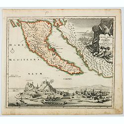
Corcyrae Insula, vulgo Corfu planities unacum parte Greciae.
A scarce map of Greece’s most northerly island, originally drawn by Christoph Weigel, well known as one of the 18th century’s most prolific map makers. To the right o...
Date: Nurnberg, ca 1720
Selling price: ????
Please login to see price!
Sold in 2021
Carte pour servir a l'intelleigence de l'Histoire Eclesiastique et a faire connoitre les persecutions de l'Eglise. . .
Map depicting Egypt and area around the Nile, Ancient world and finally Syria and the coast of Armenian Turkey down through Holy Land and Arabia Desert. Extensive histori...
Date: Amsterdam, 1720
Selling price: ????
Please login to see price!
Sold in 2023
-250x250.jpg)
Orbis Terrarum
Dutch so-called ' Staten' bibles, published between 1637 and c. 1760, contained 5 maps: The World, ' Paradise', The Perigrinations, The Promised Land Canaan, The Travels ...
Date: Amsterdam, c. 1720
Selling price: ????
Please login to see price!
Sold in 2022
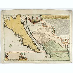
La Californie ou Nouvelle Caroline.
This fine rare map is a reissue of de Fer's map of 1705 but on a larger scale, and with some notable additions. A boldly engraved and handsome item, the largest scale map...
Date: Paris, 1720
Selling price: ????
Please login to see price!
Sold in 2022
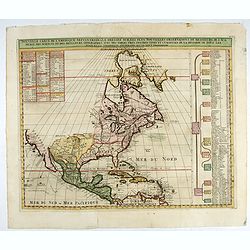
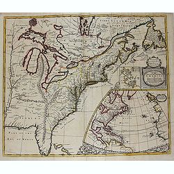
Nouvelle Carte de l' Amerique Septentrionale Dressee sur les plus Nouvelles Observations de Messieurs de l' Academie. . .
Great map of North America with well developed cartography in the Great Lakes and Mississippi River.It includes all of Central America and the West Indies. The English se...
Date: Amsterdam, 1720
Selling price: ????
Please login to see price!
Sold in 2022
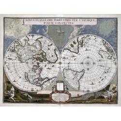
Novus Planiglobii Terrestris per Utrumque polum conspectus.
In the last years of his life, Joan Blaeu commissioned a double hemisphere world map, based on the unusual polar projection. Probably, the terrible fire of February 22, 1...
Date: Amsterdam, 1720
Selling price: ????
Please login to see price!
Sold in 2023
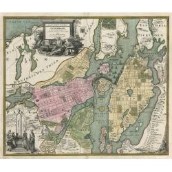
Accurater Grundriß und Prospect Der Kön. Schwed. Reichs. u. Hauptstadt Stockholm
This superb early eighteenth century map of Stockholm in full original hand colour is from Homann’s Maior Atlas Superiore. The map depicts Stockholm as it was at the ...
Date: Nuremburg, 1720
Selling price: ????
Please login to see price!
Sold in 2023
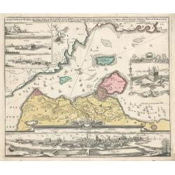
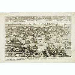
Copenhagen
This map by Johann Homann depicts the city of Copenhagen and its environs from differing perspectives, as the city appeared in the early 18th century.There is evidence of...
Date: Nuremberg, 1720
Selling price: ????
Please login to see price!
Sold in 2023
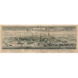
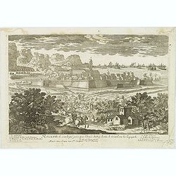
Turin
A fine example of George Balthasar Probst's panoramic bird's-eye-view of Turin, the capital city of Piedmont in northwest Italy. The river Poo, fortified walls, building...
Date: Augsburg, 1720
Selling price: ????
Please login to see price!
Sold in 2023
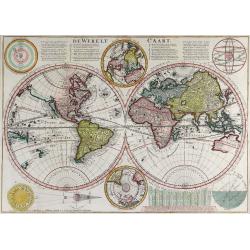
De Werelt Caart.
This is Cornelis Danckerts' second world map; his first being a re-engraved version of his father's map, published by Wetstein & Smith in Amsterdam and Luchtmans in L...
Date: Amsterdam, 1720
Selling price: ????
Please login to see price!
Sold in 2023
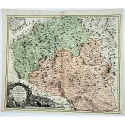
Marchionatus Moraviae Circuli Znoymensis et Iglaviensis
Marchionatus Moraviae Circuli Znoymensis et Iglaviensis quos mandato caesareo accuratè emensus hac Mappa delineatos exhibit. (1720)cartographer: Johann Christoph Mülle...
Date: Nürnberg, 1720
Selling price: ????
Please login to see price!
Sold in 2023
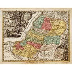
Terra Sancta.
Prepared by M.Seutter. With decorative title cartouches. Engraved by Andreas Silbereisen.
Date: Augsburg 1720
Selling price: ????
Please login to see price!
Sold
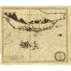
L'Île de Formosa, ou sont exactement marquez les bancs de sables, rochers et brasses d'eau, le tout fait . . .
A decorative map of the west coast of Taiwan and the Pescadores Islands (Penghu), showing little detail of the Taiwanese inland, apart from the immense mountain range.For...
Date: Leiden, 1720
Selling price: ????
Please login to see price!
Sold in 2014
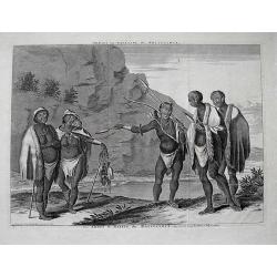
Habillemens d'hommes & de femmes de diverses provinces de la Chine. . .
An attractive view of the flying bridge in the province of Xensi, surrounded by 11 costume prints.The ethnographic studies show various types of people including physicia...
Date: Amsterdam, 1720
Selling price: ????
Please login to see price!
Sold in 2012
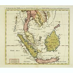
Le Royaume de Siam avec Les Royaumes Qui Luy sont Tributaries & c.
Influential map of Southeast Asia, including modern day Thailand, southern Vietnam, Cambodia, Malaysia, Singapore, Borneo, Sumatra and Java. Chatelain incorporated inform...
Date: Amsterdam, c.1720
Selling price: ????
Please login to see price!
Sold in 2014
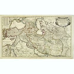
Regnum Persicum Imperium Turcicum in In Asia Russorum Provinciae ad Mare Caspium . . .
Striking map of the region bounded by Cyprus and the Eastern Mediterranean, the Nile, Medina, the Persian Gulf and the Indus River in the south and the Black Sea, Circass...
Date: Amsterdam, 1720
Selling price: ????
Please login to see price!
Sold in 2012
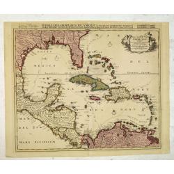
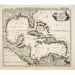
Stoel des Oorlogs in America Waar in Vertoont Werden Alle Desself Voornaamste Eylande . . .
Large impressive map of the West Indies with the Gulf of Mexico and Florida. The map shows prominently in the center Cuba, Haiti, the Bahamas and Florida, which is here m...
Date: Amsterdam, c. 1720
Selling price: ????
Please login to see price!
Sold in 2014
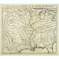
Carte de la Louisiane et du Cours du Mississipi Dressée sur un grand nombre de Memoires.
Anonymous map copied from the important de L'Isle map. The map shows "Natichitoches, éstablissemt. François fait en 1717 par Mr. De Bienville" and routes of e...
Date: Paris, c. 1720
Selling price: ????
Please login to see price!
Sold in 2012
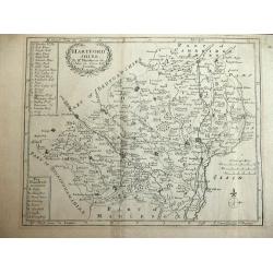
Hartfordshire.
This is an attractive and rare map of Hertfordshire.Copper engraving. Very attractive, uncommon map in good condition . Robert Morden's miniature maps are among the earli...
Date: London, 1720
Selling price: ????
Please login to see price!
Sold
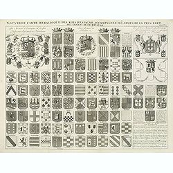
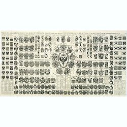
Nouvelle carte héraldique des rois d'Espagne accompagnée des armes . . .
Decorative sheet with coats of arms of Spanish and Portuguese Kings and noble families. This impressive engraving is a wonderful example of Chatelain’s elegant plates f...
Date: Amsterdam, ca. 1720
Selling price: ????
Please login to see price!
Sold in 2012
![Atlas historique. . . [Title page]](/uploads/cache/64137-250x250.jpg)
Atlas historique. . . [Title page]
This impressive engraving is a wonderful example of Chatelain’s elegant plates from his "Atlas Historique, Ou Nouvelle Introduction A L’Histoire …", Tom 1...
Date: Amsterdam, ca. 1720
Selling price: ????
Please login to see price!
Sold in 2012
Germania antiqua. / Carte de l'ancienne Germanie . . .
This impressive engraving is a wonderful example of Chatelain’s elegant plates from his "Atlas Historique, Ou Nouvelle Introduction A L’Histoire …", Tom 2...
Date: Amsterdam, ca. 1720
Selling price: ????
Please login to see price!
Sold in 2012
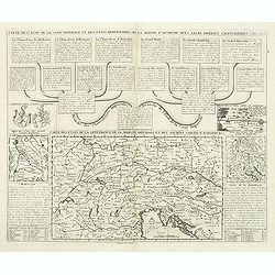
Carte de etats de la dependance de sa maieste imperiale et des anciens comtes d'Habsbourg.
This impressive engraving is a wonderful example of Chatelain’s elegant plates from his "Atlas Historique, Ou Nouvelle Introduction A L’Histoire …" Showin...
Date: Amsterdam, ca. 1720
Selling price: ????
Please login to see price!
Sold in 2012
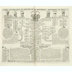
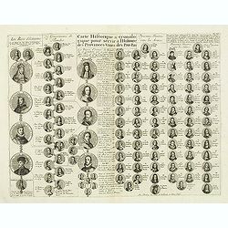
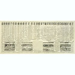
Carte genealogique de Pologne et les princiales. . .
A genealogical tree of the Polish rules from 9th - 17th century. This impressive engraving is a wonderful example of Chatelain’s elegant plates from his "Atlas His...
Date: Amsterdam, ca. 1720
Selling price: ????
Please login to see price!
Sold in 2012
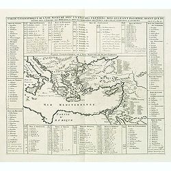
Carte geographique de l'Asie mineure avec un etat des premiers rois. . .
Map of the Mediterranean. This impressive engraving is a wonderful example of Chatelain’s elegant plates from his "Atlas Historique, Ou Nouvelle Introduction A L�...
Date: Amsterdam, ca. 1720
Selling price: ????
Please login to see price!
Sold in 2012
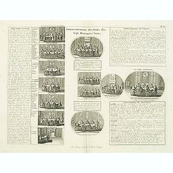
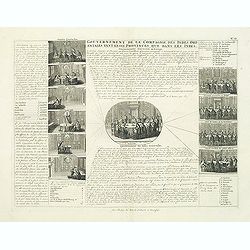
Gouvernement des etats des sept provinces Unies. . .
Print showing the infrastructure of the Dutch government, including the government of the separate provinces and the government of the state. The plate is adorned with a ...
Date: Amsterdam, ca. 1720
Selling price: ????
Please login to see price!
Sold in 2012
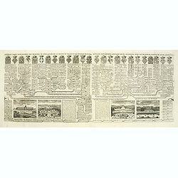
Carte historique & chronologique pour servir à l'histoire des Provinces-Unies des Pais-Bas. . .
Showing the genealogy of the ruling families of Europe who were allied with Holland at the beginning of the eighteenth century. Highly decorative, this impressive genealo...
Date: Amsterdam, ca. 1720
Selling price: ????
Please login to see price!
Sold in 2012
Gouvernement de la Compagnie des Indes Orientales tant en ces Provinces que dans les Indes.
This impressive engraving is a wonderful example of Chatelain’s elegant plates from his "Atlas Historique, Ou Nouvelle Introduction A L’Histoire …", Tom 4...
Date: Amsterdam, ca. 1720
Selling price: ????
Please login to see price!
Sold in 2012
Parte Alpestre dello Stato di Milano, con il Lago Maggiore di Lugano, e di Como.
Highly detailed copper engraved map of the Lago Maggiore, Lago di Lugano, and Lago di Como area. Includes the cities of Bergamo, Milano, Como, Arona, Bellinzona, Locarno,...
Date: Amsterdam, c1720
Selling price: ????
Please login to see price!
Sold
Colchis, Iberia, Albania..
Uncommon map covering the area in-between the Caspian Sea and the Black Sea. With decorative cartouche lower left.
Date: Amsterdam, 1720
Selling price: ????
Please login to see price!
Sold in 2012
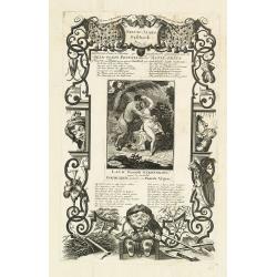
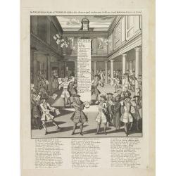
Nieuw-jaars geschenk, met narren paarde muskus geparfumeerd opgedraagen aan de geld-godin Pecunia door de actie-prins of viceroy van Plutus, in zyn niewe schuilhoek zyn wanhebbelyke liefde koesterende.
Page taken from "Het groote tafereel der dwaasheid : vertoonende de opkomst, voortgang en ondergang der actie, bubbel en windnegotie, in Vrankryk, Engeland, en de Ne...
Date: Amsterdam, 1720
Selling price: ????
Please login to see price!
Sold in 2012
Veue de la Ville de Cadix en Espagne. . .
A very RARE panoramic of the city of Cadiz.Engraved by Pierre Aveline (Paris, c.1656 - 23 May 1722). He was also a print-publisher and print-seller. He probably trained ...
Date: Paris, 1690-1720
Selling price: ????
Please login to see price!
Sold in 2012
Rozes, Ville de Catalogne par l'Armée du Roy Louis le Grand sur les Espagnols.
A very RARE panoramic of the city of Rozes.Engraved by Pierre Aveline (Paris, c.1656 - 23 May 1722). He was also a print-publisher and print-seller. He probably trained ...
Date: Paris, 1690-1720
Selling price: ????
Please login to see price!
Sold
Les trois isles appellées. . . Dantzic Marienbourg et Elbing dans la Prusse Royale. . .
Fine and uncommon map including the town of Danzig and the region south of it. East to the top.From van der Aa's very rare work La galerie agréable du Monde. Very attrac...
Date: Leiden, 1720
Selling price: ????
Please login to see price!
Sold in 2015
La Lavonie Avec les frontieres de Courlande et de Finlande . . .
Fine and uncommon map showing already quite accurate Livonia, Eastland and Curland. Many villages and towns are named.In the upper part the coast line of Finland.From van...
Date: Leiden, 1720
Selling price: ????
Please login to see price!
Sold in 2012
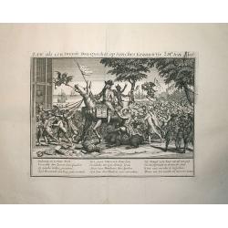
Law, als een tweede Don Quichot, op Sanches Graauwtje..
This engraving is from the important account of one the most infamous financial meltdowns in history, known as the Mississippi Bubble incident. This engraved view is titl...
Date: Amsterdam, 1720
Selling price: ????
Please login to see price!
Sold in 2012
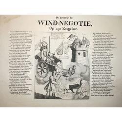
Wind-Negotie, op zijn Zeegekar.
This engraving is from the important account of one the most infamous financial meltdowns in history, known as the Mississippi Bubble incident. This engraved view is titl...
Date: Amsterdam, 1720
Selling price: ????
Please login to see price!
Sold in 2012
De Actiewereld op haar einde.
This engraving is from the important account of one the most infamous financial meltdowns in history, known as the Mississippi Bubble incident. This engraved view is titl...
Date: Amsterdam, 1720
Selling price: ????
Please login to see price!
Sold in 2012
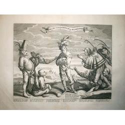
De windverkopers of Windvangers, die door wind, verliezen Geld. . .
Decorative print satirizing the stock exchange business after it collapse in the beginning of the 18th century, that led to the complete ruin of many of over-eager French...
Date: Amsterdam, 1720
Selling price: ????
Please login to see price!
Sold in 2017
A new map of the English Empire in America. . .
This fine English map of eastern North America including Canada engraved by John Harris and first published by Robert Morden. John Senex acquired and made minor alteratio...
Date: London, 1720
Selling price: ????
Please login to see price!
Sold in 2013
Carte Heraldique representant les armes de l'emperereur. . .du Saint Empire Romain.
This impressive engraving of heraldic arms of the Holy Roman Empire is a wonderful example of Chatelain’s elegant plates from his "Atlas Historique, Ou Nouvelle In...
Date: Amsterdam, ca. 1720
Selling price: ????
Please login to see price!
Sold in 2012
Carte généalogique des branches naturelles ou du coté gauche de la maison des Bourbons. . .
Interesting sheet with an impressive engraving ornamented with numerous vignettes representing French castles of Meudon, Versailles, St. Germain en Laye and Fontaine Blea...
Date: Amsterdam, ca. 1720
Selling price: ????
Please login to see price!
Sold in 2012
Carte générale des états du Czar Empereur de Moscovie ou l'on voit . . .
General map of Russia of the states of the Czar Emperor of Muscovy showing his possessions in Europe and Asia. To the left and right explanatory panels with coats of arms...
Date: Amsterdam, ca. 1720
Selling price: ????
Please login to see price!
Sold in 2012
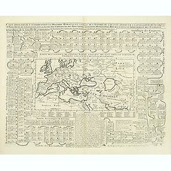
Carte pour servir d'introduction à l'histoire romaine . . .
Map of the ancient Roman Empire. This impressive engraving is a wonderful example of Chatelain’s elegant plates from his "Atlas Historique, Ou Nouvelle Introductio...
Date: Amsterdam, ca. 1720
Selling price: ????
Please login to see price!
Sold in 2012
Nouvelle carte généalogique des branches du coté gauche de la maison de valois . . .
This impressive engraving is a wonderful example of Chatelain’s elegant plates from his "Atlas Historique, Ou Nouvelle Introduction A L’Histoire …", Tom 7...
Date: Amsterdam, ca. 1720
Selling price: ????
Please login to see price!
Sold in 2012
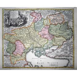
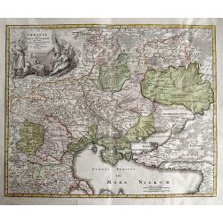
Ukrania quae et Terra Cosaccorum cum vicinis Walachiae, Moldaviae, Minorisq., Tartariae Provinciis exhibita.
Very decorative copper engraved map of the Ukraine with the Black Sea, Sea of Azov, and Crimea. Extending from Moscow to Konstantinopel (Istanbul). Highly detailed with a...
Date: Nuremberg, 1720
Selling price: ????
Please login to see price!
Sold in 2012
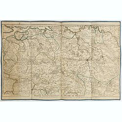
Partie septentrionale du duche de Brabant. . .
Detailed map prepared by Alex-Hubert Jaillot of the Dutch province of Brabant with the towns of 's-Hertogenbosch, Eindhoven, Helmond, Tilburg, Breda, etc. Also including ...
Date: Paris, 1720
Selling price: ????
Please login to see price!
Sold in 2015
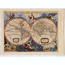
Nova Delineatio Totius Orbis Terrarum Per Petrum Vander Aa.
Originally engraved by Jacob van Meurs in 1660, and reissued here by Vander Aa, this map is based on Arnold Colom's wonderfully graphic map from the first world maritime ...
Date: Leiden, 1720
Selling price: ????
Please login to see price!
Sold in 2013
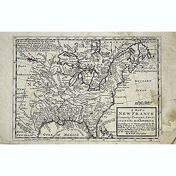
A new map of New France containing Canada, Louisiana &c. in N.th America. . .
A fine map of Canada, Great Lakes and most of South east New Foundland. For this edition the London meridian is used with Deg.West from London and Deg.East from London en...
Date: London, c. 1720
Selling price: ????
Please login to see price!
Sold in 2013
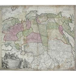
Generalis Totius Imperii Russorum Novissima Tabula.
Highly detailed map of Imperial Russia, at the beginning of the period when Russia was exploring the Pacific Ocean and Arctic Seas. Depicts Russian Empire and northern Ch...
Date: Nuremberg, 1720
Selling price: ????
Please login to see price!
Sold in 2013
Ukrania quae et Terra Cosaccorum cum vicinis Walachiae, Moldaviae, Minorisq., Tartariae Provinciis exhibita.
Rare and very decorative copper engraved map of the Ukraine with the Black Sea.
Date: Nuremberg, 1720
Selling price: ????
Please login to see price!
Sold in 2013
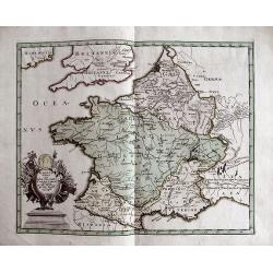
GALLIA VETUS EX IULII CAESARIS...
Interesting map of ancient France. Includes Switzerland and Benelux. With a decorative title cartouche and contemporary hand coloring.
Date: Nuremberg, c1720
Selling price: ????
Please login to see price!
Sold in 2013
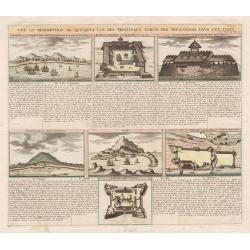
Vue et Description de quelques-uns des principaux forts des Hollandois dans les Indes.
This impressive engraving is a wonderful example of Chatelain’s elegant plates.Ornamented with numerous vignettes representing some of the Dutch settlements in the East...
Date: Amsterdam, c.1720
Selling price: ????
Please login to see price!
Sold in 2013
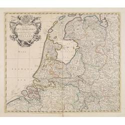
The Dutch Netherlands or the seven United Provinces. . .
Fine map of The Netherlands with decorative title cartouche. Engraved by S.Parker. Revised by John Senex.John Senex's A New General Atlas of the World was, strangely the ...
Date: London, 1720
Selling price: ????
Please login to see price!
Sold in 2013
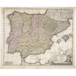
Hispaniarum Portugalliae que coronarum..
Detailed map of Spain and Portugal with large uncolored title cartouche.
Date: Amsterdam, 1720
Selling price: ????
Please login to see price!
Sold in 2025
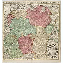
Ducatus Brabantiae, complrctens dominia Lovanii, Bruxellarum, Antverpia. . . / Carte du Brabant. . .
Covens & Mortier's map of Brabant, based upon De L'Isle's map of 1700. The North is orientated to the top side of the map. On the lower right a cartouche decorated wi...
Date: Amsterdam, 1720
Selling price: ????
Please login to see price!
Sold in 2013
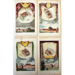
Four Town Plans of Dutch Monastaries.
Unique, detailed, hand-colored plans of Monasteries in Holland. Jan Goeree produced these in about 1720.Jan Goeree (1670-1730) was a painter, draughtsman, engraver, and e...
Date: Amsterdam, 1720
Selling price: ????
Please login to see price!
Sold in 2015
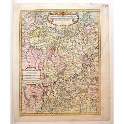
Partie Occidentale du Temporel de L'Archevesche et Eslectorat de Treves
Detailed map of Germany and part of Luxemburg. Figurative title cartouche with two putti as well as a ribboned scale cartouche. Nicolas Sanson (1600–1667) was a French...
Date: Paris, 1696 - 1720
Selling price: ????
Please login to see price!
Sold in 2013
Le Duche de Westphalie.
An Interesting map featuring the Duchy of Westfalen. With two, large, super decorative cartouches with two putti and an exraordinary compass rose. Nicolas Sanson (1600–...
Date: Paris, 1696 - 1720
Selling price: ????
Please login to see price!
Sold in 2015
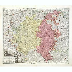
Ducatus Luxemburgi tam in Maiores quam Minores . . .
Fine map of Luxembourg by J. B. Homann. With one decorative cartouche in lower left corner.
Date: Nuremberg, ca. 1720
Selling price: ????
Please login to see price!
Sold in 2014
Insulae Americanae Nempe: Cuba, Hispaniola, Iamaica, Pto Rico, Lucania, Antillae vulgo Caribe, Barlo-et Sotto-Vento Etc. . . .
A rare re-issue of the plate by Danckerts. The West Indies with the gulf of Mexico and Florida. The map shows prominently in the center Cuba, Haiti, the Bahamas and Flori...
Date: Amsterdam, 1720
Selling price: ????
Please login to see price!
Sold in 2013
Dracht en Wapening der Hottentots.
Large format view of "Hottentots" in traditional clothing and armed with spear and bow. Located at the Cape of Good Hope. Title below the view: "Les Armes ...
Date: Leiden, c1720
Selling price: ????
Please login to see price!
Sold in 2013
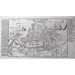
Marseille oder Marsilien.
Very detailed German plan of Marseille and environs, with the harbor and fortifications. With extensive information to the left, and a 26 letter key locating important bu...
Date: Augsburg, c1720
Selling price: ????
Please login to see price!
Sold in 2013
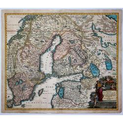
Regni Sueciae in Omnes Suas Subjacentes.
Large, detailed, hand-colored map featuring Sweden, Finland, Eastern Russia and Northern Poland, Lithuania, Latvia & Estonia. Fine allegorical title cartouche with fo...
Date: Nuremberg, 1720
Selling price: ????
Please login to see price!
Sold in 2017
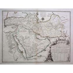
La Perse, La Georgie, La Natolie, Les Arabies, L'Egipte et le Cours du Nile. .
A scarce regional map showing the Asian territories of Ottoman Empire with emphasis on the course of river Nile. The map has an elaborate cartouche showing the ethnic pop...
Date: Paris, c 1720
Selling price: ????
Please login to see price!
Sold in 2013
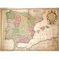
Hispania ex Archetypo Roderici Mendez Sylvae.
Striking copperplate map of Spain & Portugal. Decorative allegorical cartouche with an older man's head and two white horses. The Lotter family were engravers and pub...
Date: Augsburg, 1720
Selling price: ????
Please login to see price!
Sold in 2014
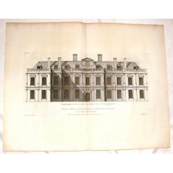
The Elevation of Althrop in Northampton Shire.
Fine copper engraving of Althrop, the seat of the Right Honorable Earl of Sunderland. Included in the famous architectural publication, "Vitruvious Britannicus"...
Date: London, 1720
Selling price: ????
Please login to see price!
Sold in 2016
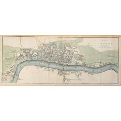
Plan of London in the reign of Queen Elizabeth.
Plan of London in the reign of Queen Elizabeth 1st 1546. This delicately hand colored early map of London is highly detailed. This map dated 1720 by James Stratford of Ho...
Date: London, 1720
Selling price: ????
Please login to see price!
Sold in 2014
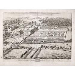
Southwick in the County of Southampton Seat of Richard Norton Esq.
Engraved by Joannes Kip after the drawing by Leonard Knyff. Plate 74 from "Britannia Illustrata or Views of Several of the Queens Palaces and also of the Principal S...
Date: London, 1720
Selling price: ????
Please login to see price!
Sold in 2017
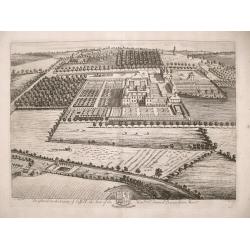
Brightwel in the County of Suffolk the seat of the Honourable Sir Barnardiston Barr.
Brightwel in the County of Suffolk the seat of the Honourable Sir Barnardiston Barr. Plate 52 from "Britannia Illustrata or Views of Several of the Queens Palaces...
Date: London, 1720
Selling price: ????
Please login to see price!
Sold in 2017
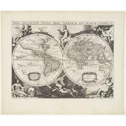
Nova delineatio Orbis Terrarum..
Very decorative with double hemispheres surrounded by six figures representing earth, fire, water, day, and night. It Shows California as an island. Based on Colom's rare...
Date: Leiden, 1720
Selling price: ????
Please login to see price!
Sold in 2013
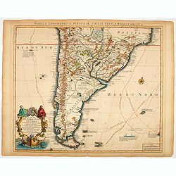
Carte du Paraguay, du Chili, du Detroit de Magellan &c.
A finely engraved, detailed map of the southern half of South America. Prepared by de l'Isle.
Date: Amsterdam, 1720
Selling price: ????
Please login to see price!
Sold in 2014