Browse Listings
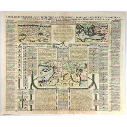
Carte pour Conduire a l'Inteligence de L'Histgoire Sacree...
This sheet includes three maps that illustrate Holy Land biblical history. The main map at centre (Carte de l'introduction du peuple d'Israel dans les Pais de Canaan) sho...
Date: Paris, 1719
Selling price: ????
Please login to see price!
Sold in 2016
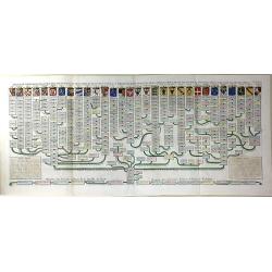
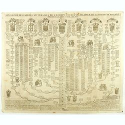
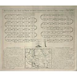
Nouvelle Carte Genealogique des Souverains et des Familles Illustres Aliez a la Maison Ouaux Decendans de la Famille Roialle de Piaste Roi de Pologne...
A genealogical tree of the Royal family of Poland from AD.804 to AD.1704. Produced as a supplement to a 7 volume "Atlas Historique" by Henry Chatelaine in1710. ...
Date: Amsterdam, 1719
Selling price: ????
Please login to see price!
Sold in 2016
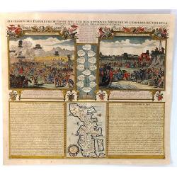
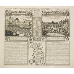
Succession des Empereurs du Japon avec une Description du Meutre de L'Empereur Cubo...
A composite sheet with a small map of Japan and two detailed views, one depicting the murder of the Emperor Cubo, the other, the reception of the Dutch ambassadors, each ...
Date: Amsterdam, 1719
Selling price: ????
Please login to see price!
Sold in 2019
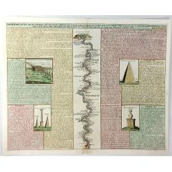
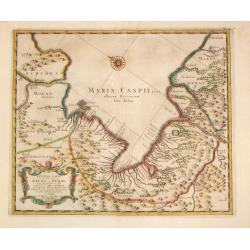
Description du Nil de Ses Sources de Son Cours Depuis les Cataractes Jusques au Caire ....
A fine folio engraving centred on the river Nile (with north at the bottom), stretching from the 1st cataract at Aswan to Cairo with accompanying text in French. On eithe...
Date: Amsterdam, 1719
Selling price: ????
Please login to see price!
Sold in 2021
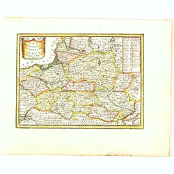
Les Estats de la Couronne de Pologne.
The very rare first edition published by Antoine Menard (with his signature) in 1711 in "Le Nouveau et Curieux Atlas géographique et historique.". The map is m...
Date: Paris, 1719
Selling price: ????
Please login to see price!
Sold in 2020
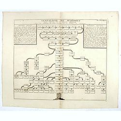
Généalogie de Mahomet, depuis Ismael, fils du patriarche Abraham. (The genealogy of Mohammed, since Ismael, son of patriarch Abraham)
The genealogy of Mohammed, since Ismael, son of patriarch Abraham.Henri Abraham Chatelain (1684 – 1743) was a Huguenot pastor of Parisian origins. He lived consecutivel...
Date: Amsterdam, 1719
Selling price: ????
Please login to see price!
Sold in 2016
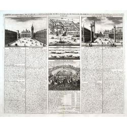
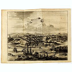
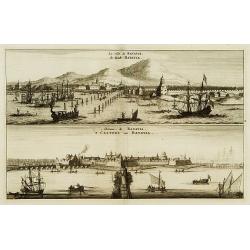
Carte du Gouvernement Militaire de la Republique du Venise...
Very decorative folio sheet with five engraved views in Venice: "Vue de la Palace de St. Marc" (Piazza San Marco), a birds-eye map of "L'Arcenal", &qu...
Date: Amsterdam, 1719
Selling price: ????
Please login to see price!
Sold in 2016
Carte Genealogique de la Maison de Nassau.
A fine, very detailed genealogical Map of the House of Nassau Orange. It is an antique engraving with the pedigrees of the House Nassau Wiesbaden and Nassau Dillenburg. T...
Date: Amsterdam, 1719
Selling price: ????
Please login to see price!
Sold in 2016
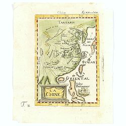
La Chine.
A charming small map of China, Taiwan, Philippines, Korea and Kyushu (Japan).From the "Des berühmten Königlichen geographi" the German Edition of "Descri...
Date: Frankfurt, 1719
Selling price: ????
Please login to see price!
Sold in 2017
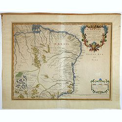
Le Bresil, dont les côtes sont divisées en capitaineries Dressé sur les dernières rélation. . .
Uncommon issue of this fine map of Brazil prepared by Nicolas de Fer, issued by Guillaume Danet.Originally published in atlas Atlas Curieux by N. de Fer in 1700-05, at hi...
Date: Paris, 1719
Selling price: ????
Please login to see price!
Sold in 2017
![Carte nouvelle des Terres de Cucan. . . [India]](/uploads/cache/38871-250x250.jpg)
Carte nouvelle des Terres de Cucan. . . [India]
All the trading posts of the V.O.C. are marked with a flag. Prepared by H.Reland (1676-1718) a professor active in Utrecht and specialised in Asian languages, geography a...
Date: Amsterdam, 1719
Selling price: ????
Please login to see price!
Sold in 2017
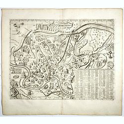
Plan Des Antiquitez De Rome Representes Et Distingues Suivant La Situation De Chacun De Ses Anciens Monuments.
Copper engraved plan of Ancient Rome, identifying over 100 a hundred buildings, bridges, churches, fountains. Taken from Chatelain's monumental 7 volume Atlas Historique,...
Date: Amsterdam, 1719
Selling price: ????
Please login to see price!
Sold in 2017
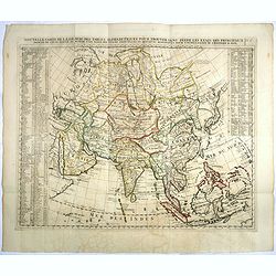
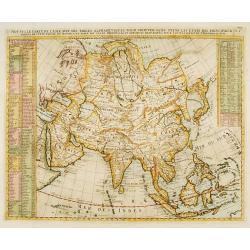
Nouvelle Carte De L'Asie Avec Des Tables Alphabetiques Pour Trouver Sans Peine Les Etats Des Principaux Princes De Cette Partie Du Monde . . .
Chatelain's map of Asia. The title is in two lines across the map. On each side, the border appears an index to the map's contents. The map is based upon Guillaume De L'I...
Date: Amsterdam, 1719
Selling price: ????
Please login to see price!
Sold in 2023
Nisen-Navgorod ville de la moscovie, Capitale du Duche de meme nom.
Decorative view of Nizhniy Novgorod (Gorky) on the Oka and Volga river. This well executed engraving was published in 1729 and 1727 by Pieter van der AA, in Leiden in &qu...
Date: Leiden, 1719
Selling price: ????
Please login to see price!
Sold in 2018
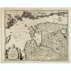
La Livonie avec les frontieres de Courlande et de Finlande . . .
Decorative map of Livonia. This well executed engraving was published in 1729 and 1727 by Pieter van der AA, in Leiden in "Les Voyages tres-curieux et tres-renommez ...
Date: Leiden, 1719
Selling price: ????
Please login to see price!
Sold in 2017
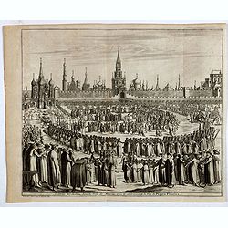
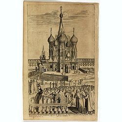
Château Kremlin, dans la ville de Moscou, avec la celebration de la fête de Pâques fleuries.
Decorative view of Kremlin during the Procession on Palm Sunday. This well executed engraving was published in 1729 and 1727 by Pieter van der AA, in Leiden in "Les ...
Date: Leiden, 1719
Selling price: ????
Please login to see price!
Sold in 2018
Moscou, capitale de la Moscovie suivant Olearius.
Decorative view of Moscow city, oriented to the west. At the base of the map there are a series of decorative views illustrating Russian hunters and farmers. A decorative...
Date: Leiden, 1719
Selling price: ????
Please login to see price!
Sold in 2017
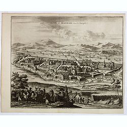
La ville de Bagdad, dans la Turquie.
Decorative view of Bagdad. This well executed engraving was published in 1729 and 1727 by Pieter van der AA, in Leiden in "Les Voyages tres-curieux et tres-renommez ...
Date: Leiden, 1719
Selling price: ????
Please login to see price!
Sold in 2021
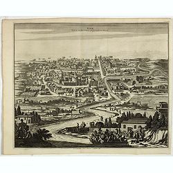
Kom, ville de la Province d'Yerack, en Perse. (Qom).
Decorative view of Kom (Qom). This well executed engraving was published in 1729 and 1727 by Pieter van der AA, in Leiden in "Les Voyages tres-curieux et tres-renomm...
Date: Leiden, 1719
Selling price: ????
Please login to see price!
Sold in 2021
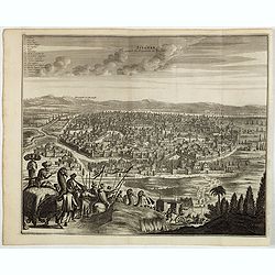
Ispahan, capitale du Royaume de Perse. (Isfahan)
Decorative view of Ispahan (Isfahan), then the Capital of the Kingdom of Persia. This well executed engraving was published in 1729 and 1727 by Pieter van der AA, in Leid...
Date: Leiden, 1719
Selling price: ????
Please login to see price!
Sold in 2021
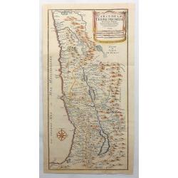
Carte de la Terre Promise. . .
An attractive copper engraved map of the Holy Land as divided into the 12 tribes of Israel. It has a large drapery title cartouche and a prominent compass rose. Nicolas d...
Date: Paris, 1719
Selling price: ????
Please login to see price!
Sold in 2017
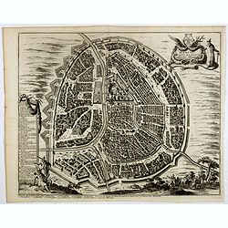
Novogorod, ville de la Moscovie . . .
Decorative map of Novogorod, city of Moscovie. This well executed engraving was published in 1729 and 1727 by Pieter van der AA, in Leiden in "Les Voyages tres-curie...
Date: Leiden, 1719
Selling price: ????
Please login to see price!
Sold in 2017
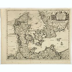
Le Royaume de Danermark . . .
Decorative map of Denmark. This well executed engraving was published in 1729 and 1727 by Pieter van der AA, in Leiden in "Les Voyages tres-curieux et tres-renommez ...
Date: Leiden, 1719
Selling price: ????
Please login to see price!
Sold in 2019
![[Title page] Les Voyages du sieur Adam Olearius . . .](/uploads/cache/39550-250x250.jpg)
[Title page] Les Voyages du sieur Adam Olearius . . .
Title page. This well executed engraving was published in 1729 and 1727 by Pieter van der AA, in Leiden in "Les Voyages tres-curieux et tres-renommez faits en Moscov...
Date: Leiden, 1719
Selling price: ????
Please login to see price!
Sold in 2017

Adam Olearius . . .
Portrait of Adam Olearius. This well executed engraving was published in 1729 and 1727 by Pieter van der AA, in Leiden in "Les Voyages tres-curieux et tres-renommez ...
Date: Leiden, 1719
Selling price: ????
Please login to see price!
Sold in 2017
St Trinité, ou Jerusalem, Eglise de Moscou . . .
Decorative view of St Trinité church in Moscow. This well executed engraving was published in 1729 and 1727 by Pieter van der AA, in Leiden in "Les Voyages tres-cur...
Date: Leiden, 1719
Selling price: ????
Please login to see price!
Sold in 2019
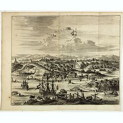
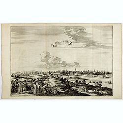
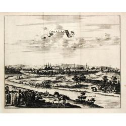
La ville de Moscou, capitale de la Moscovie.
Decorative panoramic view of Moscow. Below the engraving a numbered key (1- 24) of the important buildings of the city. This well executed engraving was published in 1729...
Date: Leiden, 1719
Selling price: ????
Please login to see price!
Sold in 2017
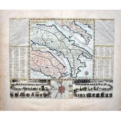
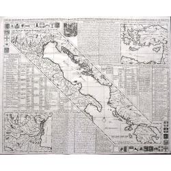
L'Italie Dans Son Premier Etablissement Sous La Republique Romaine Dans La Division par Cesar Auguste Et Ses Differents Gouvermens Sous Les Papes.
A most fascinating map of Italy. It encompasses maps of Italy during modern times (beginning of the XVIII century), at the time of Cesear, and at the time of the beginnin...
Date: Amsterdam, 1719
Selling price: ????
Please login to see price!
Sold in 2022
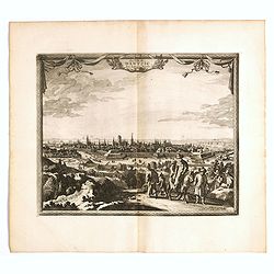
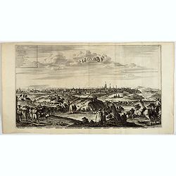
La ville de Dantzic dans la Prusse Royale.
Decorative view of Danzig. This well executed engraving was published in 1719 by Pieter van der AA, in Leiden in "Les Voyages tres-curieux et tres-renommez faits en ...
Date: Leiden, 1719
Selling price: ????
Please login to see price!
Sold in 2019
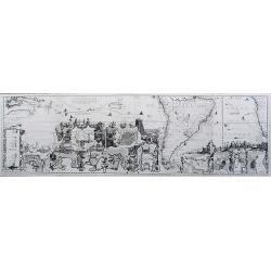
Carte tres Curieuse de la Mer du Sud... (southern sheet only)
The bottom half of Chatelain's famous and highly decorative map. Extends to show a partial Australia with dates of discoveries, the Pacific Ocean, South America, the Sout...
Date: Amsterdam, 1719
Selling price: ????
Please login to see price!
Sold in 2017
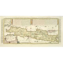
Carte de l'Ile de Java: partie Occidentale, partie Orientale, Dressée tout nouvellement sur les Mémoirs les plus exacts, Avec une Table des principales villes de cette Ile. . .
An inset plan of Batavia and clearly indicated rice fields, mountains, forests, towns in profile and even elephants suggest the wealth of detail found on this map. Modell...
Date: Amsterdam, François L'Honoré & Châtelain, 1719
Selling price: ????
Please login to see price!
Sold in 2020
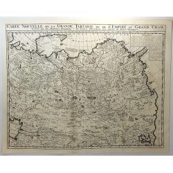
Carte Nouvelle de la Grande Tartarie ou de L'Empire du Grand Cham. . .
A strongly engraved map of Russia, from the Caspian Sea to Korea, filled with minute detail and beautifully engraved to show the topography. Inset of explanatory French t...
Date: Amsterdam, 1719
Selling price: ????
Please login to see price!
Sold in 2018
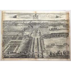
The Mote, One of the Seats of Ye Right Honorable the Lord Romney.
A fine detailed bird's eye view of 'The Mote', showing the house, gardens and the avenues of trees stretching out into the surrounding park. Title along top edge, coat of...
Date: London, 1719
Selling price: ????
Please login to see price!
Sold in 2018
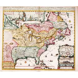
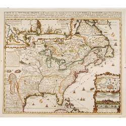
Carte de la Nouvelle France, ou se voi le cours. . .
Derived from de Fer's 1718 map, from west of the Mississippi it contains a mass of inland detail with notes and vignettes of the indigenous peoples and fauna of North Ame...
Date: Amsterdam, 1719
Selling price: ????
Please login to see price!
Sold in 2019
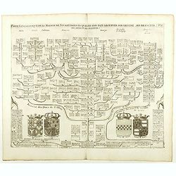
Carte Genealogique De La Maison De Stuart, Dans La Quelle L'On Fait Observer Son Origine, Ses Branches.
Fine example of Chatelain's attractive plate showing the genealogy of the House of Stuart, decorated with four coats-of-arms pertaining to military alliances. Zacharie Ch...
Date: Amsterdam, 1719
Selling price: ????
Please login to see price!
Sold in 2021
Genealogie des Familles souverains de l'Europe issues par alliance de la maison de France . . .
Fine example of Chatelain's attractive plate showing the genealogy of the important royal families of Europe, decorated with coats-of-arms. Zacharie Chatelain (d.1723) wa...
Date: Amsterdam, 1719
Selling price: ????
Please login to see price!
Sold in 2018
Nouvelle carte genealogique des principaux souverains de l'Europe issus de la Famille Roiale de France . . .
Fine example of Chatelain's attractive plate showing the genealogy of the important royal families of Europe, decorated with coats-of-arms. Zacharie Chatelain (d.1723) wa...
Date: Amsterdam, 1719
Selling price: ????
Please login to see price!
Sold in 2018
La France divisée en ses douze anciens gouvernements, et en ses vingt quarte nouveaux.
Fine example of Chatelain's attractive plate showing the division of the different governments, decorated with coats-of-arms. Zacharie Chatelain (d.1723) was the father o...
Date: Amsterdam, 1719
Selling price: ????
Please login to see price!
Sold in 2018
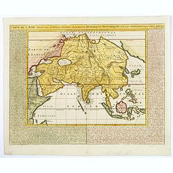
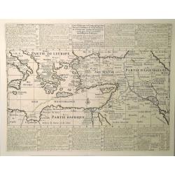
Carte de l'Asie selon les auteurs anciens enrichie de remarques historiques. . .
The pleasant map is centered on the India and the Indian Ocean, with explanatory text on either side of the map. It shows the ancient kingdoms and empires of the continen...
Date: Amsterdam, 1719
Selling price: ????
Please login to see price!
Sold in 2018
Nisen-Navgorod ville de la moscovie, Capitale du Duche de meme nom.
Decorative view of Nizhniy Novgorod (Gorky) on the Oka and Volga river. This well executed engraving was published in 1729 and 1727 by Pieter van der AA, in Leiden in &qu...
Date: Leiden, 1719
Selling price: ????
Please login to see price!
Sold in 2019
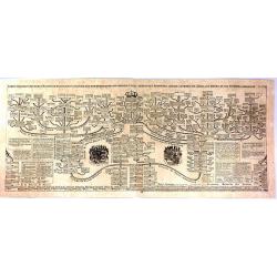
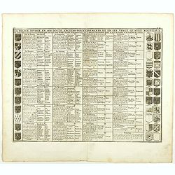
Succession des Rois de Perse Anciens & Modernes, Depuis Cyrus Jusqu'a a Present.
A striking and highly detailed fine and unusual copper engraved plate including, on one sheet, a genealogical tree, showing the Kings of Persia Iran), from Cyrus in 3468 ...
Date: Amsterdam, 1719
Selling price: ????
Please login to see price!
Sold in 2019
Carte Historique et Geographique pour Servir a L'Histoire Ste et a la Vocation de St. Paul. . .
An historical map of the Mediterranean region and Middle East. It details the major trade routes (both on land and over sea). This detailed map marks the travels of St. P...
Date: Amsterdam, 1719
Selling price: ????
Please login to see price!
Sold in 2023
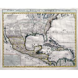
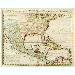
Carte contenant le Royaume du Mexique et la Floride. . .
A double-page engraved map of Texas, Florida, the Gulf Coast, and Central America, based on Guillaume De L'Isle's important Carte du Mexique. It shows parts of the Great ...
Date: Amsterdam, 1719
Selling price: ????
Please login to see price!
Sold in 2019
Carte de geographie des differents etats de la Republique de Venise. . .
A fine map of the Adriatic Sea and Gulf of Venice, extending until Athens and Peloponnese. It names islands such as Corfu, Kefalonia,, and many of the Croatian islands. I...
Date: Amsterdam, 1719
Selling price: ????
Please login to see price!
Sold in 2019
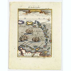
Isles Caribes.
A very handsome small colored map of the Caribbean, extending to include the shores of northern South America. The map is inserted in a prospective view of the Caribbean ...
Date: Frankfurt, 1719
Selling price: ????
Please login to see price!
Sold in 2019
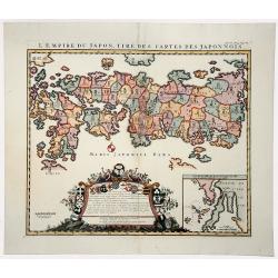
L'EMPIRE DU JAPON, TIRE DES CARTES DES JAPONNOIS (JAPAN).
A beautiful old colored map, which was published by Henri Chatelain in 1719 for his 'Atlas Historique'. Published from 1705 to 1720, the 'Atlas Historique' was intended f...
Date: Amsterdam, 1719
Selling price: ????
Please login to see price!
Sold in 2019
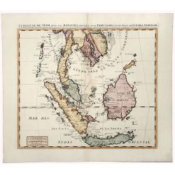
LE ROYAUME DE SIAM avec les ROYAUMES QUI LUY sont TRIBUTAIRES et les Isles de SUMATRA ANDEMAON.
A beautiful, old colored map of South East Asia shows the Kingdom of Siam (Thailand), the Malaysian Peninsula and the islands of Borneo, Sumatra and Java. This was the do...
Date: Amsterdam, 1719
Selling price: ????
Please login to see price!
Sold in 2019
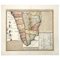
Carte Nouvelle des Terres de CUCAN, de CANARA, de MALABAR, de MADURA,m et de COROMANDL.
India south of Goa, from Chatelain's monumental 'Atlas Historique', published in Amsterdam. The map includes three text boxes giving particulars of the region and its div...
Date: Amsterdam, 1719
Selling price: ????
Please login to see price!
Sold in 2019
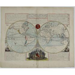
MAPPE-MONDE pour connoitre les progrès & les conquestes les plus Remarquables des Provinces-Unies...
The voyages and discoveries of the Dutch East India and Dutch West India Companies are the subject of this handsome, double-hemisphere map of the world.The map shows an i...
Date: Amsterdam, 1719
Selling price: ????
Please login to see price!
Sold in 2020
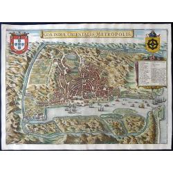
Goa Indiae orientalis metropolis.
A decorative and detailed birds-eye view of the city and harbour of Goa. The map is based upon an earlier map by Jan Huygen van Linschoten. Linschoten served 6 years as t...
Date: Leiden, 1719
Selling price: ????
Please login to see price!
Sold in 2020
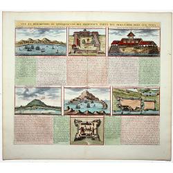
Vue et description de quelques-uns des principaux forts des Hollandois dans les Indes. (Dutch Forts).
A clean plate with seven detailed views illustrating the most important Dutch trading outposts and fortified colonial possessions in the East Indies. This plate includes ...
Date: Amsterdam, 1719
Selling price: ????
Please login to see price!
Sold in 2019
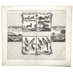
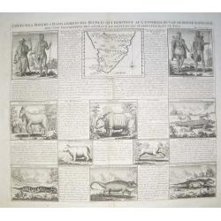
DESCRIPTION DES QUADRUPEDES, OISEAUX & REPTILES LES PLUS CURIEUX QUI SE TROUVENT DANS LA GUINEE . . .
A decorative copperplate engraving showing quadrupeds, reptiles and the birds of Guinea, including a scene with elephants, from Henri Chatelain's monumental 7 volume &quo...
Date: Amsterdam, 1719
Selling price: ????
Please login to see price!
Sold in 2019

Le Nouveau et Curieux Atlas Geographique et historique, ou Le Divertissement des Empereurs, Roys, et Princes. Tant dans la Guerre que dans la Paix. Dédié A Son A.R. Monseigneur le Duc d'Orléans Regent du Roîaume de France.
Charming world atlas with double hemisphere world and the North American map feature the Island of California. In Asia and the Pacific, Australia is incompletely mapped a...
Date: Paris, 1719
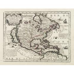
L'Amerique Septentrionale qui fait partie des Indes Occidentales..
A handsome miniature-map showing California as an island after Sanson. Sanson's details are generally followed.The British colonies are shown confined east of the Appalac...
Date: Paris, 1719
Selling price: ????
Please login to see price!
Sold in 2017
Carte de la Nouvelle France, ou se voi le cours. . .
Derived from de Fer's 1718 map, from west of the Mississippi it contains a mass of inland detail with notes and vignettes of the indigenous peoples and fauna of North Ame...
Date: Amsterdam, 1719
Selling price: ????
Please login to see price!
Sold
Carte contenant le Royaume du Mexique et la Floride.
This is a derivative of Delisle's landmark map of the southern part of North America. The detailed map shows many English settlements along the East Coast and carefully n...
Date: Amsterdam, 1719
Selling price: ????
Please login to see price!
Sold in 2019
La ville de Batavie / Cheaçteau de Batavia.
From La Galerie agréable du monde.
Date: Leiden c.1719
Selling price: ????
Please login to see price!
Sold
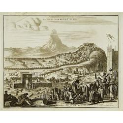
La ville de Derbendt, en Perse.
Originally engraved for Dapper's important compilations of travels in Asia and Persia. Pieter van der AA acquired several plates who he later used in his own publications...
Date: Leiden, c. 1719
Selling price: ????
Please login to see price!
Sold in 2013
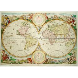
Werelt Caert.
Beautiful double hemisphere from a Dutch Bible. Surrounded by allegorical representations of the continents, based on Visscher. CALIFORNIA IS AN ISLAND with a flat northe...
Date: Amsterdam 1719
Selling price: ????
Please login to see price!
Sold
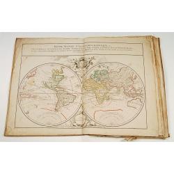
Atlas with 19 maps, 2 Family trees and 3 historical tables.
Atlas including a double hemisphere world map, maps of Europe, Asia, Africa, North America (engraved by Cordier, showing California as an Island, based upon Sanson's land...
Date: Paris, 1719
Selling price: ????
Please login to see price!
Sold
Nouvelle carte de l'Asie avec des tables..
Chatelain's map of Asia. The title is in two lines across the map. On each side border appears an index to the map's contents.From Chatelain's Atlas Historique et Méthod...
Date: Amsterdam 1719
Selling price: ????
Please login to see price!
Sold
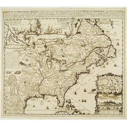
Carte de la Nouvelle France, ou se voi le cours..
Derived from de Fer's 1718 map, from west of the Mississippi it contains a mass of inland detail with notes and vignettes of the indigenous peoples and fauna of North Ame...
Date: Amsterdam 1719
Selling price: ????
Please login to see price!
Sold
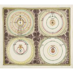
Systema Ptolomaicum/Systema Copernicanum / Systema Tychonicum/Systema Cartesianum.
Four inset maps, each depicting one of the theories of the Solar System. Each system is enclosed in engraved clouds and stars.Part of a title page from his atlas Atlas me...
Date: Nüremberg, 1719
Selling price: ????
Please login to see price!
Sold
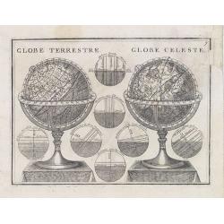
Globe Terrestre - Globe Celeste.
Attractive engraving showing a pair of terrestrial and celestial table globes.From Le Nouveau et Curieux Atlas Geographique et Historique.. by Jacques Chiquet.Mounted on ...
Date: Paris, 1719
Selling price: ????
Please login to see price!
Sold in 2013
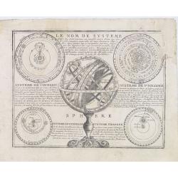
Le Nom de Systeme..
Attractive engraving centered on an armillary sphere, showing four versions of the solar system according to the different theories in the corners.With explanatory text i...
Date: Paris, 1719
Selling price: ????
Please login to see price!
Sold in 2013
Coutumes, Moeurs et Habillemens des Peuples qui Habitent aux Environs du Cap de Bonne Esperance..
Decorative images of people & animals, with a map of southern Africa after Tachard. The people depicted are the Hottentots and the Namaquas of the Cape of Good Hope. ...
Date: Amsterdam, c. 1719
Selling price: ????
Please login to see price!
Sold in 2008
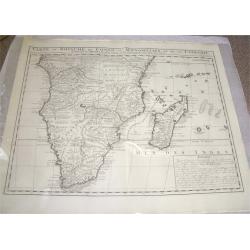
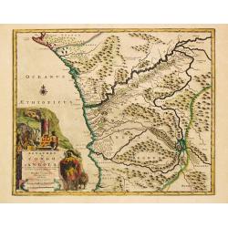
Carte du Royaume de Congo, du Monomotapa et de la Cafrerie.
A detailed map of Southern Africa. Effectively De Lisle map of 1708, this is the French version by Chatelain,with a text block at lower right describing the Congo, Monomo...
Date: Amsterdam, c.1719
Selling price: ????
Please login to see price!
Sold
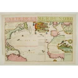
Carte de la Mer du Nord.
Fine map of the Atlantic Ocean. An extremely rare edition of the De Fer map. With 3 inset maps. Lower right Cape of Good Hope, upper right Gibraltar, and in upper center ...
Date: Paris 1719
Selling price: ????
Please login to see price!
Sold
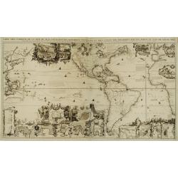
Carte très curieuse de la Mer du Sud, contenant des remarque..
One of the most spectacular examples of the marriage between cartography and graphic art.Based on de Fer's map of 1713. One map on 4 sheets, showing America in the middle...
Date: Amsterdam 1719
Selling price: ????
Please login to see price!
Sold in 2008
Succession de Empereurs du Japan avec une description du meutre de l' Emperuer Cubo et la Reception des Ambassadeurs Hollandoois en ce pays la. / Carte du Japon.
Henri Abraham Chatelain was a Amsterdam-based geographer and publisher. His main product is the 'Atlas Historique et Méthodique', in seven volumes, published between 171...
Date: Amsterdam, 1719
Selling price: ????
Please login to see price!
Sold
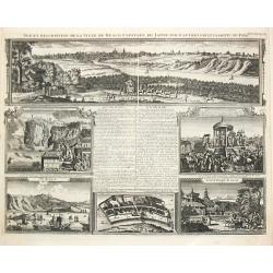
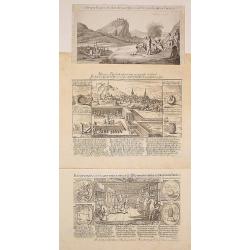
Vue et Desription de la Ville de Meaco Captitale du Japon avec d' autre particularitez du Pays. / Ville de Saccai. / Loge des Hollandois a Nanguesague / Grand Temple de Saccay.
Henri Abraham Chatelain was a Amsterdam-based geographer and publisher. His main product is the 'Atlas Historique et Méthodique', in seven volumes, published between 171...
Date: Amsterdam, 1719
Selling price: ????
Please login to see price!
Sold
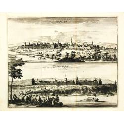
Soratof / Tzornogor.
Pieter van der Aa was a prolific publisher. He published a.o. ' Naauwkeurge versameling der gedenkwaardigste zee- en land-reysen', a series of accounts of voyages (1706-0...
Date: Leiden, 1719
Selling price: ????
Please login to see price!
Sold
La Fortresse de Noteburg.
Pieter van der Aa was a prolific publisher. He published a.o. ' Naauwkeurge versameling der gedenkwaardigste zee- en land-reysen', a series of accounts of voyages (1706-0...
Date: Leiden, 1719
Selling price: ????
Please login to see price!
Sold in 2010
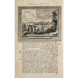
Moruma.
Pieter van der Aa was a prolific publisher. He published a.o. ' Naauwkeurge versameling der gedenkwaardigste zee- en land-reysen', a series of accounts of voyages (1706-0...
Date: Leiden, 1719
Selling price: ????
Please login to see price!
Sold
Carte du Canada ou de la Nouvelle France ..
Chatelain's map of Canada follows in its rendering of the Great Lakes closely the de l'Isle model of 1703 but from an entirely new plate with a large panel of text in pla...
Date: Amsterdam 1719
Selling price: ????
Please login to see price!
Sold
Carte très curieuse de la Mer du Sud, contenant des remarque..
Based on de Fer's map of 1713. One map on 4 sheets, showing America in the middle with Europe on one side and the Pacific with Japan and China on the other. Top sheets of...
Date: Amsterdam 1719
Selling price: ????
Please login to see price!
Sold
Nouvelle Carte de la province de Kilian en Perse.
Pieter van der Aa was a prolific publisher. He published a.o. ' Naauwkeurge versameling der gedenkwaardigste zee- en land-reysen', a series of accounts of voyages (1706-0...
Date: Leiden, 1719
Selling price: ????
Please login to see price!
Sold in 2009
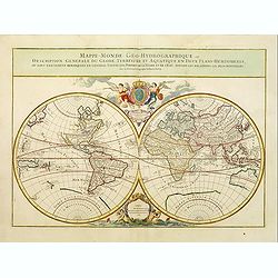
Mappe-Monde Geo-Hydrographique, ou Description Generale...
MAP OF THE WORLD DEDICATED TO THE KING. Large map of the world in two hemispheres, in a stereographic projection. California seems to be connected to the mainland, rather...
Date: Paris, 1719
Selling price: ????
Please login to see price!
Sold in 2013
Royaumes de Congo et d'Angola.
Pieter van der Aa was a prolific publisher. He published a.o. ' Naauwkeurge versameling der gedenkwaardigste zee- en land-reysen', a series of accounts of voyages (1706-0...
Date: Leiden, 1719
Selling price: ????
Please login to see price!
Sold
3 prints dealing with manufacturing of canons.
2 prints dealing with manufacturing of canons, etc. Very rare. Together with engraving of an attack of the town (Hohentwiel?).
Date: Zürich 1696/1719
Selling price: ????
Please login to see price!
Sold