Browse Listings
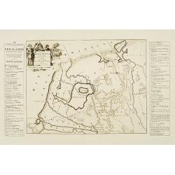
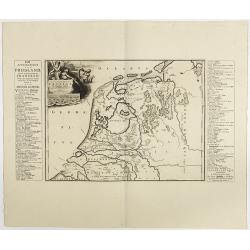
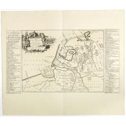
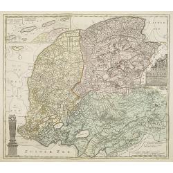
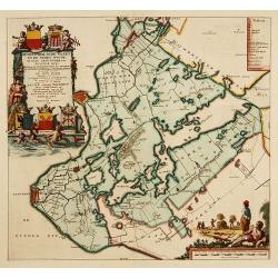
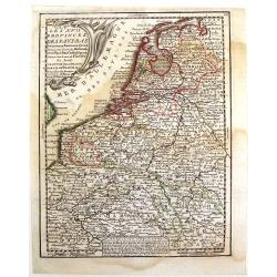
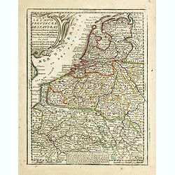
Descriptio Agri Frisii..
Historical map of the northern part of the Netherlands, north of the river Rhine and east of the river Elbe. Prepared by the Menso Alting (1637-1713). He was burgomaster ...
Date: Amsterdam 1718
Selling price: ????
Please login to see price!
Sold
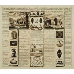
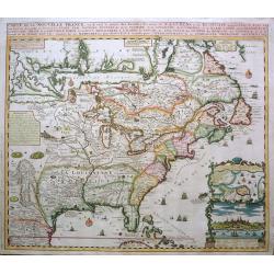
Carte qui contient la maniere.. Niagara..
A series of 12 engravings together with descriptive text, derived from the works of Lahontan and Hennepin, illustrating the methods of the Indians hunting buffalo and sim...
Date: The Hague 1718
Selling price: ????
Please login to see price!
Sold
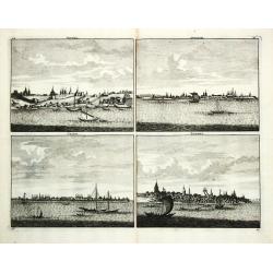
Niesna / Swyatski / Casan / Samara
Four views on one sheet of Russian towns.
Date: Amsterdam, 1718
Selling price: ????
Please login to see price!
Sold
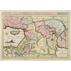
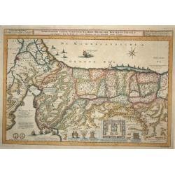
De gelegentheyt van 't Paradys en ' t Landt Canaan
Bottom right:' t Amsterdam uytgegeven door Cornelis Dankerts voor aen op de Nieuwendijck in den Atlas met Previlegie. This Cornelis Danckerts ( the spelling of his name d...
Date: Amsterdam, 1718
Selling price: ????
Please login to see price!
Sold in 2013
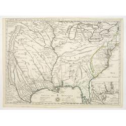
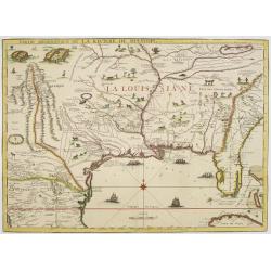
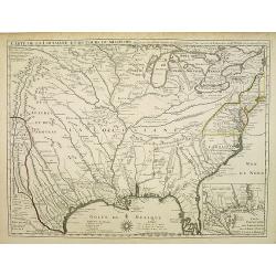
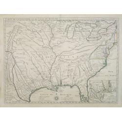
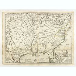
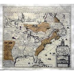
Carte de la Louisiane et du cours du Mississipi.
First issue, first state (New Orleans not yet located) of “the first detailed map of the Gulf region and the Mississippi, [and] the first printed map to show Texas”(T...
Date: Paris 1718
Selling price: ????
Please login to see price!
Sold
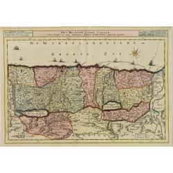
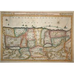
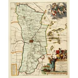
Het Beloofde Landt Canaan
First state. Map of the Holy Land as travelled by Christ and the Apostles. Oriented to the west. The shore line runs from Biblium to Rinocorura. This Cornelis Danckerts (...
Date: Amsterdam, 1718
Selling price: ????
Please login to see price!
Sold in 2008
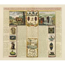
Carte qui contient la maniere.. Niagara..
A series of 12 engravings together with descriptive text, derived from the works of Lahontan and Hennepin.They illustrate the methods of the Indians hunting buffalo and s...
Date: The Hague 1718
Selling price: ????
Please login to see price!
Sold
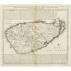
Nouvelle Carte de L'Isle de Ceylon, avec des remarques Historiques.
Handsome and very detailed map of the island. The mountainous topography is graphically presented, along with roads, locations of Dutch forts, gem and salt mines. Numerou...
Date: Amsterdam 1718
Selling price: ????
Please login to see price!
Sold
Partie Meridionale de La Riviere de Missisipi..
The printed version of the most important map of the Mississippi Valley and Gulf of Mexico, prepared in manuscript by De L'Isle (Carte des Environs du Mississippi, 1701) ...
Date: Paris, 1718
Selling price: ????
Please login to see price!
Sold in 2013
Afbeeldinge van de Veertich-Iaarige Reyse der Kinderen Israels..
Attractive and decorative map of the Holy Land divided into the twelve Tribes of Israel, depicting the Exodus from Egypt and the wanderings of the Children of Israel. The...
Date: Amsterdam, 1718
Selling price: ????
Please login to see price!
Sold in 2008
Het Beloofde Landt Canaan.
Finely engraved and very detailed map of the Holy Land embellished with sailing ships and compass rose. Dutch text on verso, engraved by Albert Schut. First state.
Date: Amsterdam, 1718
Selling price: ????
Please login to see price!
Sold in 2008
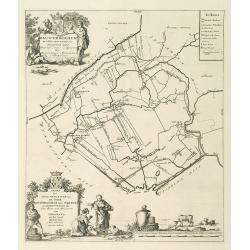
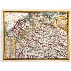
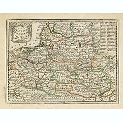
Descriptio Frisiae. . .
Historical map of the present-day Low Countries prepared by the Menso Alting (1637-1713). He was burgomaster of Groningen and geographer, who prepared in 1701 his histori...
Date: Leeuwarden, F.Halma, 1718
Selling price: ????
Please login to see price!
Sold in 2018
Descriptio veteris Agri Batavi et Frisii. . .
Historical map of the present-day Low Countries prepared by the Menso Alting (1637-1713). He was burgomaster of Groningen and geographer, who prepared in 1701 his histori...
Date: Leeuwarden, F.Halma, 1718
Selling price: ????
Please login to see price!
Sold in 2018
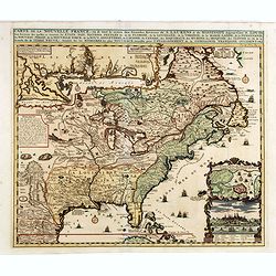
Carte de la Louisiane et du cours du Mississipi.
First issue, second state. First map to name New Orleans. This map is known for its detailed depiction of the states adjacent to the Gulf of Mexico region and the Mississ...
Date: Paris, 1718
Selling price: ????
Please login to see price!
Sold in 2008
Nouvelle carte de l'Afrique avec des remarques et des tables pour trouver sans peine les differents peuples de cette partie du Monde par les Renvois Alphabetiques suivant les plus nouvelles ...
Nouvelle carte de l'Afrique avec des remarques et des tables pour trouver sans peine les differents peuples de cette partie du Monde par les Renvois Alphabetiques suivant...
Date: Amsterdam, 1718
Selling price: ????
Please login to see price!
Sold in 2008
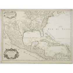
Carte du Mexique et de la Floride des Terres Angloises et des Isles Antilles du Cours et des Environs de la Riviere de Mississipi ... Par Guillaume Del\'Isle Geographe de l\'Academie Royale des Scieces.
Rare first edition, second state of the first printed map to accurately depict the course and mouth of the Mississippi River. De L\'Isle\'s Carte du Mexique is drawn from...
Date: Paris, 1703 / 1708-1718
Selling price: ????
Please login to see price!
Sold in 2009
Carte de la Louisiane et du cours du Mississipi.
First issue, first state. New Orleans not yet listed!. This map is known for its detailed depiction of the states adjacent to the Gulf of Mexico region and the Mississipp...
Date: Paris, 1718
Selling price: ????
Please login to see price!
Sold
Frisiae dominium vernaculé Friesland. . .
Very detailed and decorative map of Friesland. Upper left hand corner inset map of the Frisian islands. Lower left statue of the Steenen Man of Harlingen. Key map from th...
Date: Amsterdam, 1718
Selling price: ????
Please login to see price!
Sold in 2013
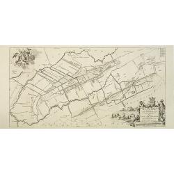
Stellingwerf westeinde, de tiende en laafte Grientenije van de Zevenwolden. . .
Very decorative map, with decorative title cartouche lower right, and with three finely engraved cherubs in the upper left corner holding a coat of arms. From the Uitbeel...
Date: Amsterdam, 1718
Selling price: ????
Please login to see price!
Sold in 2010
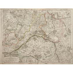
Carte de la Beauce du Gatinois de la Sologne et Pays voifins compris dans la Generalite d\'Orleans.
Detailed map of region of central France south of Paris. The Loire River is depicted with the city of Orleans in the center of the map. The Loire was once an important na...
Date: Paris, 1718
Selling price: ????
Please login to see price!
Sold in 2010
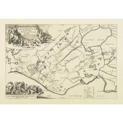
Gaasterland. De zevende Grietenije van de Zevenwolden. . .
Very detailed map of "Gaasterland. De zevende Grietenije van de Zevenwolden" in Friesland prepared by Bernardus Schotanus Steringa. With Sloter Meer and the tow...
Date: Leeuwarden, 1718
Selling price: ????
Please login to see price!
Sold in 2014
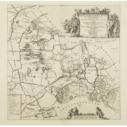
Tjietjerkstera deel. De achtste Grietenije van Ooster-Goo. . .
Very detailed map of "Tjietjerkstera deel. De achtste Grietenije van Ooster-Goo" in Friesland prepared by Bernardus Schotanus Steringa. Centered on Bergum and B...
Date: Leeuwarden, 1718
Selling price: ????
Please login to see price!
Sold in 2014
De Grietenije van Smallingerland de negende grietenij van Oostergo
Very detailed map of "De Grietenije van Smallingerland de negende grietenij van Oostergo" in Friesland prepared by Bernardus Schotanus van Steringa. With decora...
Date: Leeuwarden, 1718
Selling price: ????
Please login to see price!
Sold in 2018
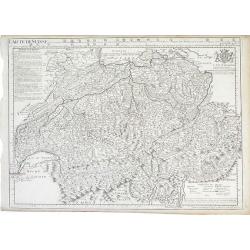
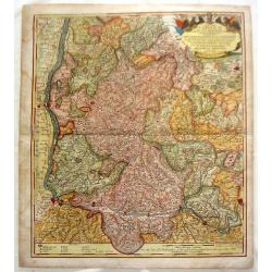
Carte De Suisse.
Detailed map of Switzerland showing different cantons (administrative units) within the country extending to the borders of France, Italy and Germany. The map includes a ...
Date: Paris, 1718
Selling price: ????
Please login to see price!
Sold in 2010
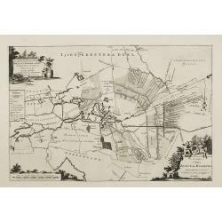
Rauwerderhem de elfde grietenije van Oostergoo . . .
A very detailed map of "Rauwerderhem de elfde grietenije van Oostergoo" in Friesland prepared by Bernardus Schotanus Steringa. Centered on Deersum with in lower...
Date: Leeuwarden, 1718
Selling price: ????
Please login to see price!
Sold in 2010
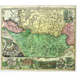
SERBIA - BANAT. UNGARISCHES KRIEGS THEATRUM.
A large and detailed, very decorative map of the theatre of war between the Austrians and Ottoman Turks 1716-17, fought in Romania and Serbia. Under Prince Eugene of Savo...
Date: Nuremberg, 1718
Selling price: ????
Please login to see price!
Sold in 2022
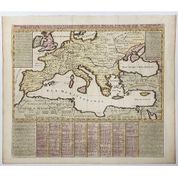
Nouvella Carte des Conciles Generaux et Particuliers qui se sont tenus en Europe, en Asie, En Afrique etc. . .
A fine map of the lands bordering the Mediterranean Sea, including Most of Europe, North Africa & Western Asia. The map was drawn to show the cities where Ecclesial C...
Date: Paris, 1718
Selling price: ????
Please login to see price!
Sold in 2020
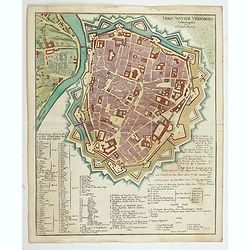
Urbis Augustae Vindobonae.
Engraved city map of Augsburg by Christoph Weigel. Plan of the city with fortifications, left Leopoldstadt, below an extensive key with description. From Bequemer Schul- ...
Date: Nuremberg, 1718
Selling price: ????
Please login to see price!
Sold in 2023
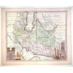
Imperii Persici delineatio...
An attractive map of Persia/Iran, with vignettes of ancient monuments.
Date: Nuremberg, 1718
Selling price: ????
Please login to see price!
Sold in 2014
Leeuwerdera deel.. der stad Leeuwerden. . .
Very decorative map centered on Leeuwarden from the Uitbeelding der Heerlijkheit Friesland prepared by Schotanus. With decorative title cartouche lower right mentioning t...
Date: Amsterdam, 1718
Selling price: ????
Please login to see price!
Sold in 2012
Hemelumer oude vaart en de Noort Woude. . .
Very decorative map including the towns of Staveren, Hindelopen, Workum and several of the Frisian Lakes from the Uitbeelding der Heerlijkheit Friesland prepared by Schot...
Date: Leeuwarden, F.Halma, 1718
Selling price: ????
Please login to see price!
Sold in 2014
Imp. Caes. Carolo VIAugusto Pio Victori.
Highly decorative copperplate map showing Breisgau & Schwarzwald provinces featuring "The Black Forest" & the River Rhine. Interesting allegorical title...
Date: Nuremberg, 1718
Selling price: ????
Please login to see price!
Sold in 2014
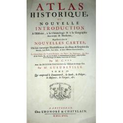
(Title plate from ): ATLAS HISTORIQUE, OU NOUVELLE INTRODUCTION A l\'Histoire, a la Chronologie & a la Geographie Ancienne & Moderne;...TOME IV
Title plate from "ATLAS HISTORIQUE, OU NOUVELLE INTRODUCTION A l'Histoire, a la Chronologie & a la Geographie Ancienne & Moderne;...TOME IV".
Date: Amsterdam, 1718
Selling price: ????
Please login to see price!
Sold in 2016
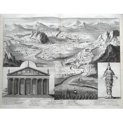
A plan of the city of Ephesus according to Pitton de Tournefort.
Large and important map in a birds-eye view of the ancient Greek city Ephesus near today's Izmir. Shows the city from the seaside with numerous buildings. A 1-20 number k...
Date: London, 1718
Selling price: ????
Please login to see price!
Sold in 2016
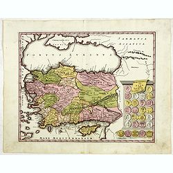
Asia peninsula sive Asia intra Taurum. . . (with Cyprus)
Striking map the Black Sea, Cyprus and Asia Minor, featuring the geographical features known to the ancients and decorated with a vignette and 27 medallions.From "De...
Date: Nuremberg, 1718
Selling price: ????
Please login to see price!
Sold in 2015
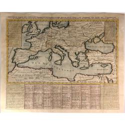
Nouvelle Carte des Conciles Generaux et Particuliers qui se sont Tenus en Europe...
A fine map of the lands bordering the Mediterranean Sea, including Most of Europe, North Africa & Western Asia.The map was drawn to show the cities where Ecclesial Co...
Date: Paris, 1718
Selling price: ????
Please login to see price!
Sold in 2016
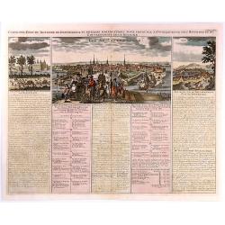
Carte de l'Etat du Royaume de Dannemarck...
Views of the Kingdom of Denmark and various observations about the history and government of this Kingdom.The map shows three views: Friderichsbourg, Copenhagen and Berge...
Date: Amsterdam, 1718
Selling price: ????
Please login to see price!
Sold in 2017
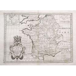
A New Map of Ancient Gaul or Gallia Transalpina...
Decorative map of France, as divided by Augustus Ceasar during Roman times. With the large title cartouche bearing the Royal Coat of Arms.
Date: London, 1718
Selling price: ????
Please login to see price!
Sold in 2016
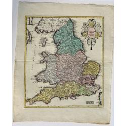
Anglia Cambdeni, excusa a Christopho Weigelio Norimbergae.
A copper engraved map, overall size 50 x 40 cm.This map shows England and Wales, with parts of Scotland. From Weigels' 'Schul und Reise atlas'. Elaborate cartouche with 5...
Date: Nurnberg, ca. 1718
Selling price: ????
Please login to see price!
Sold in 2017
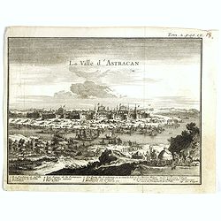
La ville d'Astracan.
Panoramic view of the town of Astracan, based on the observations of Jan Janszoon Struys. In lower part a numbered key (1-14) to the most important buildings.From "I...
Date: Amsterdam, ca. 1718
Selling price: ????
Please login to see price!
Sold in 2017

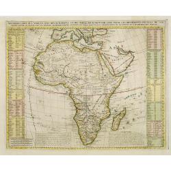
Nouvelle carte de l'Afrique avec des remarques et des tables pour trouver sans peine les differents peuples de cette partie du Monde par les Renvois Alphabetiques suivant les plus nouvelles Observations de Messieurs de l'Academie des Siences.
Decorative map of Africa, with text borders on both sides. The map is based on Delisle's landmark map of Africa (1700), which was the first to present a non-Ptolemaic ver...
Date: Amsterdam, 1718
Selling price: ????
Please login to see price!
Sold in 2017
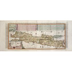
CARTE DE L'ILE DE JAVA: PARTIE OCCIDENTALE, PARTIE ORIENTALE DRESSEE...
A decorative large format map of Java, with an inset of the bay of Batavia in the lower left corner.Two title banners include a short sketch of the history of the Dutch o...
Date: Amsterdam, 1718
Selling price: ????
Please login to see price!
Sold in 2017

Johannes Curolus Eckenberg . . .
Rare portrait of Johannes Curolus Eckenberg, engraved by Johann Benjamin Brühl (1691–1763). In the center a half portrait, surrounded by nine small, numbered performan...
Date: Leipzig, ca. 1718
Selling price: ????
Please login to see price!
Sold in 2025
Carte de la Louisiane et du cours du Mississipi.
First issue, first state. New Orleans not yet listed!. This map is known for its detailed depiction of the states adjacent to the Gulf of Mexico region and the Mississipp...
Date: Paris, Juin 1718
Selling price: ????
Please login to see price!
Sold in 2018
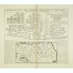
Genealogie des anciens empereurs Tartares,. . .
In lower part a map Russia including Tartary (158 x 290mm.) flanked by text in French. In top a family tree of the descendants of Genghis Khan.From Chatelain's "Atla...
Date: Amsterdam, 1719
Selling price: ????
Please login to see price!
Sold in 2012
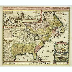
Carte de la Nouvelle Franc, ou se voi le cours des grandes rivieres. . .
Derived from de Fer's 1718 map, from west of the Mississippi it contains a mass of inland detail with notes and vignettes of the indigenous peoples and fauna of North Ame...
Date: Amsterdam, 1719
Selling price: ????
Please login to see price!
Sold in 2017
Carte de la Nouvelle Franc où se voit le cours des Grandes Rivières de St Laurens et de Mississipi Aujourd'hui St Louis . . .
Derived from de Fer's 1718 map, from west of the Mississippi it contains a mass of inland detail with notes and vignettes of the indigenous peoples and fauna of North Ame...
Date: Amsterdam, 1719
Selling price: ????
Please login to see price!
Sold in 2012
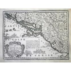
Les Isles et Coste de la Dalmatie. . .
An interesting map of the Dalmatian coast with the Republique of Raguse (Dubrovnik) at the centre. Based on Sanson's map from 1665. The area shown extends from Zadar in C...
Date: Paris, 1719
Selling price: ????
Please login to see price!
Sold in 2014
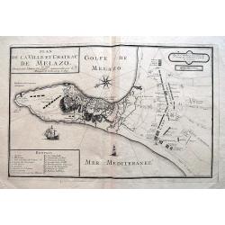
Plan de la Ville et Chateau de Melazo,...
Very rare map of the city and bay of Milazzo in Sicily. Shows the town during the attacks through the Spanish during 1718 and 1719. Illustrates the town and fortification...
Date: Paris, 1719
Selling price: ????
Please login to see price!
Sold in 2016
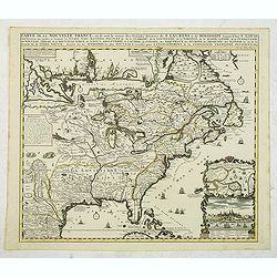
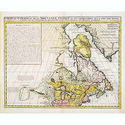
Carte du Canada ou de la Nouvelle France, & des Découvertes qui y ont été faites..
Chatelain's map of Canada follows in its rendering of the Great Lakes closely the de l'Isle model of 1703 but from an entirely new plate with a large panel of text in pla...
Date: Amsterdam, 1719
Selling price: ????
Please login to see price!
Sold in 2014
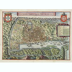
Goa Indiae orientalis metropolis.
A fine example of a rare plan of this important Indian city and port, the focal point for Portuguese trading activity in southern Asia. Pictorial map by Pieter Boudewyn v...
Date: Leiden, 1719
Selling price: ????
Please login to see price!
Sold in 2015
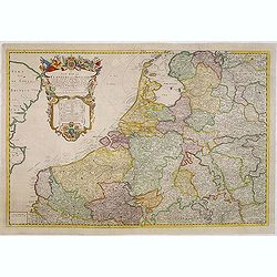
A new map of the Flanders and Holland. . .
Uncommon and large attractive map of The Low Countries. According to the title cartouche the map was printed by Charles Inselin in Paris. The cartouche with the address o...
Date: London or Paris,? c.1707-1719
Selling price: ????
Please login to see price!
Sold in 2015
Carte du Canada ou de la Nouvelle France, & des Découvertes qui y ont été faites..
Chatelain's map of Canada follows in its rendering of the Great Lakes closely the de l'Isle model of 1703 but from an entirely new plate with a large panel of text in pla...
Date: Amsterdam, 1719
Selling price: ????
Please login to see price!
Sold in 2013
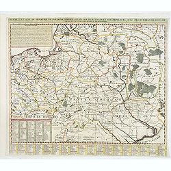
Nouvelle carte du royaume de Pologne, divisée selon. . .
Chatelain's map of Poland. The title is in two lines across the map. On bottom border appears an index to the map's contents. At the top of the map appear historical rema...
Date: Amsterdam, 1719
Selling price: ????
Please login to see price!
Sold in 2015
Carte de la Nouvelle France, où se voit le cours des Grandes Rivières de S. Laurens & de Mississipi
An intricate map of eastern North America was copied from De Fer and designed to show the courses of the St. Laurence and the Mississippi rivers. One inset charts the mou...
Date: Amsterdam, 1719
Selling price: ????
Please login to see price!
Sold in 2013
Les XVII Provinces des Pays Bas.
A pleasant little map of the Netherlands. It features the twelve provinces and has an insert explaining the "Rebellion d'Hollande." JACQUES CHIQUET (1673-1721) ...
Date: Paris, 1719
Selling price: ????
Please login to see price!
Sold in 2016
L'Empire d'Allemagne Divise en ses Dix Cercles.
Interesting little, copper engraved map of Germany divided into its ten circles. It is adorned with a fancy cartouche and a chart with the different rulers through the ye...
Date: Paris, 1719
Selling price: ????
Please login to see price!
Sold in 2016
Werelt Caert
Lovely double hemisphere map from a Dutch Bible. Title inside the surrounding allegorical representations of the continents, based on Visscher. CALIFORNIA IS AN ISLAND wi...
Date: Amsterdam, 1719
Selling price: ????
Please login to see price!
Sold in 2013
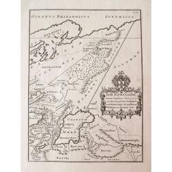
Joh. Newcombe Senator Consularis...
Unusual map of Ancient western Russia and the Caucasus, with a strangely shaped Caspian Sea. Filled with ancient place names and regions. Rare and very curious map taken ...
Date: London, 1719
Selling price: ????
Please login to see price!
Sold in 2014
![Le Nom de système [...] Système de Copernic [...] Système de Ptolomée [...] SPHERE. . .](/uploads/cache/34363-250x250.jpg)
Le Nom de système [...] Système de Copernic [...] Système de Ptolomée [...] SPHERE. . .
Attractive engraving centered on an armillary sphere, showing four versions of the solar system according to the Copernican and Ptolemaic systems, among others.With expla...
Date: Paris, 1719
Selling price: ????
Please login to see price!
Sold in 2015
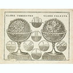
Globe Terrestre. / Globe Celeste.
A very decorative depiction of a terrestrial and celestial globe on a decorative base. The page is filled with seven diagrams.From Le Nouveau et Curieux Atlas Geographiqu...
Date: Paris, 1719
Selling price: ????
Please login to see price!
Sold in 2015
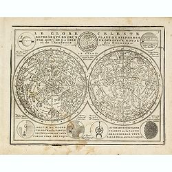
Le Globe Celeste Representé En Deux Plans-Hemispheres..
Small double hemisphere celestial map based on the observations of Philippe de la Hire, a famous French astronomer. La Hire was one of the first to present the full celes...
Date: Paris, 1719
Selling price: ????
Please login to see price!
Sold in 2014
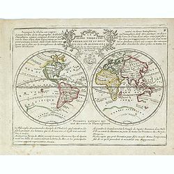
Le Globe Terrestre Representé en Deux Plans-Hemispheres..
Small double hemisphere world map featuring the Island of California and a Northwest Passage. There is little interior detail with only major nations named.Ter. de Jesso ...
Date: Paris, 1719
Selling price: ????
Please login to see price!
Sold in 2021
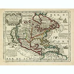
L'Amerique Septentrionale qui fait partie des Indes Occidentales..
A handsome miniature-map showing California as an island after Sanson. Sanson's details are generally followed.The British colonies are shown confined east of the Appalac...
Date: Paris, 1719
Selling price: ????
Please login to see price!
Sold in 2014
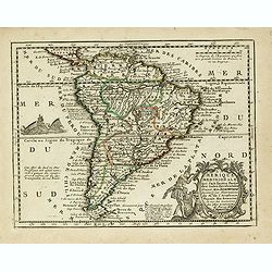
L' Amerique Meridionale qui fait l' autre Partie des Indes Occidentales, Dressée tres Exactement Suivant les Observations..
Charming small map of the South American continent with good detail. Decorated with a title cartouche with two natives in the Atlantic and a sea battle being waged in the...
Date: Paris, 1719
Selling price: ????
Please login to see price!
Sold
Les XVII Provinces Des Pays Bas..
Decorative map of the Low Countries, extending southwards as far as the North-East of France.From Le Nouveau et Curieux Atlas Geographique et Historique.. by Jacques Chiq...
Date: Paris, 1719
Selling price: ????
Please login to see price!
Sold in 2021
Les Estats de la Couronne de Pologne.
Lovely small map of Poland with title cartouche and a panel in the upper right corner listing local rulers.From Le Nouveau et Curieux Atlas Geographique et Historique.. b...
Date: Paris, 1719
Selling price: ????
Please login to see price!
Sold in 2014
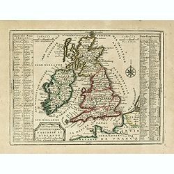
Les Royaumes D'Angleterre, D'Escosse Et D'Irlande. . .
Lovely small map of the British Isles with two side panels listing Scottish and English kings.From Le Nouveau et Curieux Atlas Geographique et Historique.. by Jacques Chi...
Date: Paris, 1719
Selling price: ????
Please login to see price!
Sold
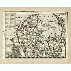
Le Royaume de Danemark Subdivisée en ses quatre Dioceses..
Lovely small map of Denmark, with decorative title cartouche.It shows a text table in the upper left corner containing the names of local rulers.From Le Nouveau et Curieu...
Date: Paris, 1719
Selling price: ????
Please login to see price!
Sold in 2015
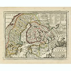
Estats de la Couronne de Suede dans la Scandinavie, ou sont Suede, Gotlande, Lapponie Suedoise, Finlande, Ingrie et Livonie. Subdivisees en leurs Provinces..
Lovely small map centered on Finland, with Sweden and much of Norway to the west, Frontieres de Moscovie to the east.Depiction of lakes, rivers and coastline reminiscent ...
Date: Paris, 1719
Selling price: ????
Please login to see price!
Sold in 2019
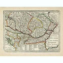
Le Royaume de Hongrie ou se trouvent La Transilvanie, La Moldavie, La Valaquie, L'esclavonie, La Bosnie, La Servie, et la Bulgarie..
Map of Hungary including most part of southeastern Europe as far as Istanbul.It shows a text table at the bottom containing the names of Hungarian rulers.From Le Nouveau ...
Date: Paris, 1719
Selling price: ????
Please login to see price!
Sold in 2016
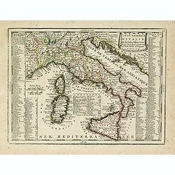
Carte Generale D'Italie Et des Isles Adjacentes. . .
Decorative map of Italy displaying at both sides a list containing the names of the popes. In the Tyrrhenian Sea instead, a table presents a list of the Antipopes.From Le...
Date: Paris, 1719
Selling price: ????
Please login to see price!
Sold in 2023
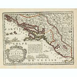
Les Isles et Coste de la Dalmatie ou se Trouvent la Republique de Raguse..
Fine map of the Dalmatian coast with a decorative title cartouche.Presents vessels in the Adriatic Sea and some text containing information about the Republic of Ragusa, ...
Date: Paris, 1719
Selling price: ????
Please login to see price!
Sold in 2016
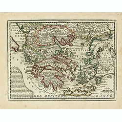
La Grece ou Partie Meridionale de la Turquie d'Europe. . .
Decorative map of Greece displaying precise engraving and a title cartouche flanked by 2 winged female figures, surmounted by a fan shaped shell.Another cartouche contain...
Date: Paris, 1719
Selling price: ????
Please login to see price!
Sold in 2017
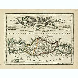
Isle et Royaume de Candie.
Uncommon small map of Crete displaying precise engraving and a flourishing, banner-style cartouche.From Le Nouveau et Curieux Atlas Geographique et Historique.. by Jacque...
Date: Paris, 1719
Selling price: ????
Please login to see price!
Sold in 2014
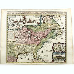
Carte De La Nouvelle France, ou se voit le cours des Grandes Rivieres de. S. Laurens & de Mississipi Aujour d'hui S. Louis, Aux Environs des-quelles se trouvent les Etats, Pais, Nations, Peuples &c. de la Floride, de la Louisiane, de la Virginie, de la M
Nice original old color rare single sheet map of the inhabited parts of North America. This map is based on the 4-sheet map by Nicholas De Fer which appeared in 1718.This...
Date: Paris, 1719
Selling price: ????
Please login to see price!
Sold in 2016
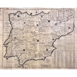
Carte Historique Et Geographique Des Royaumes D Espagne Et De Portugal Divises Selon Leurs Royaume et Provinces
Very detailed map of Spain and Portugal. Coats of arms and substantial details throughout the regions are delineated.From Chatelain's monumental Atlas Historique (in 7 vo...
Date: Amsterdam, 1719
Selling price: ????
Please login to see price!
Sold in 2014
Carte de la Nouvelle France, ou se voi le cours..
Derived from de Fer's 1718 map, from west of the Mississippi it contains a mass of inland detail with notes and vignettes of the indigenous peoples and fauna of North Ame...
Date: Amsterdam, 1719
Selling price: ????
Please login to see price!
Sold
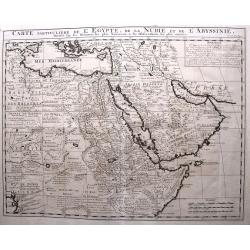
Carte Particuliere de L'Egypte, de l Nubie et de L'Abbisinie.
This (large) beautiful map is based on the work of the important French cartographer Guillaume Delisle. It is a very detailed and fascinating view of northeastern Africa,...
Date: Amsterdam, 1719
Selling price: ????
Please login to see price!
Sold in 2016
Carte de la Nouvelle France, ou se voi le cours..
Derived from de Fer's 1718 map, from west of the Mississippi it contains a mass of inland detail with notes and vignettes of the indigenous peoples and fauna of North Ame...
Date: Amsterdam, 1719
Selling price: ????
Please login to see price!
Sold in 2022