Browse Listings
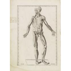
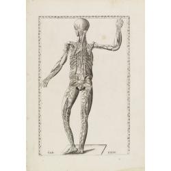
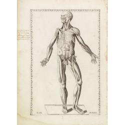
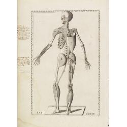
Anatomical print. TAB. XXXII.
Decorative and rare full-page anatomical copperplate engraving by Giulio de' Musi after a drawing by Eustachius and Pier Matteo Pini. From Tabulae anatomicae. In 1552, t...
Date: Rome, Francesco Gonzaga, 1714
Selling price: ????
Please login to see price!
Sold in 2013
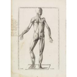
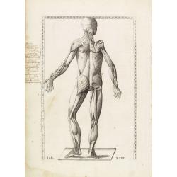
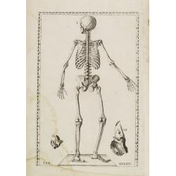
Anatomical print. TAB. XXIX.
Decorative and rare full-page anatomical copperplate engraving by Giulio de' Musi after a drawing by Eustachius and Pier Matteo Pini. From Tabulae anatomicae. In 1552 wit...
Date: Rome, Francesco Gonzaga, 1714
Selling price: ????
Please login to see price!
Sold in 2013
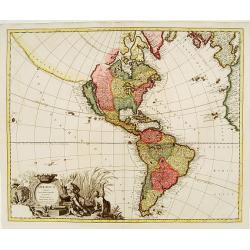
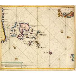
America Aurea pars altera mundi.
California is copied from second Sanson map, with rugged coastline throughout, and with Fretum Anianiand Terra Esonis to northwest.Place names along California coast, but...
Date: Amsterdam c. 1714
Selling price: ????
Please login to see price!
Sold
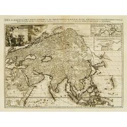
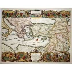
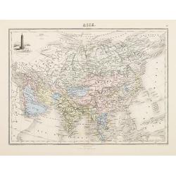
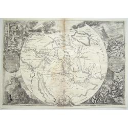
Asia in Praecipuas Ipsius partes distributa ad observationes
Van der Aa is considered the most accomplished Dutch engraver of his period. He raised the art of map ornamentation to its highest level of sophistication through the use...
Date: Amsterdam, 1714
Selling price: ????
Please login to see price!
Sold in 2010

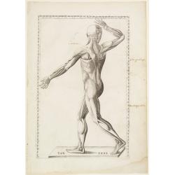
Anatomical print. TAB. XXXVI.
Decorative and rare full-page anatomical copperplate engraving by Giulio de' Musi after a drawing by Eustachius and Pier Matteo Pini. From Tabulae anatomicae..In 1552, wi...
Date: Rome, Francesco Gonzaga, 1714
Selling price: ????
Please login to see price!
Sold in 2013
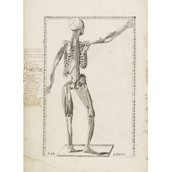
Anatomical print. TAB.XXIV.
Decorative and rare full-page anatomical copperplate engraving by Giulio de' Musi after a drawing by Eustachius and Pier Matteo Pini. From Tabulae anatomicae. In 1552 wit...
Date: Rome, Francesco Gonzaga, 1714
Selling price: ????
Please login to see price!
Sold in 2013
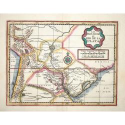
Les Provinces de Rio de la Plata.
Extremely rare map of the region including the Paraguay River basin and the Peru-Chilean coast with Lake Titicaca. The Rio de la Plata is boldly shown with many large isl...
Date: Leiden 1714
Selling price: ????
Please login to see price!
Sold
De Beschryvingh van de Reysen Pauli.
Title: De Beschryvingh van de Reysen Pauli en van de andere apostelen.This is an original map from a Dutch Keur bible of 1714. colorful map of the eastern Mediterranean f...
Date: Amsterdam 1714
Selling price: ????
Please login to see price!
Sold
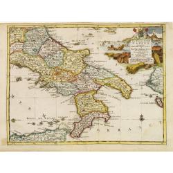
Le Royaume de Naples..
Uncommon and detailed map of southern Italy, from Nouvelle atlas, trés-exact et fort commode pour toutes sortes de personnes, contenant les principales cartes géographi...
Date: Leiden 1714
Selling price: ????
Please login to see price!
Sold
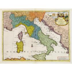
L'Italie.
Uncommon and detailed map of Italy, from Nouvelle atlas, trés-exact et fort commode pour toutes sortes de personnes, contenant les principales cartes géographiques.. .A...
Date: Leiden 1714
Selling price: ????
Please login to see price!
Sold
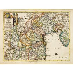
Seigneurie de Venise..
Uncommon and detailed map of the Gulf of Venice and its mainland, from Nouvelle atlas, trés-exact et fort commode pour toutes sortes de personnes, contenant les principa...
Date: Leiden 1714
Selling price: ????
Please login to see price!
Sold
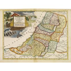
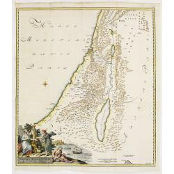
Terre Sainte suivant les nouvelles observations de Mess. De l'Academie Royale des Sciences. Etc.
Uncommon and detailed map of Holy Land, from Nouvelle atlas, trés-exact et fort commode pour toutes sortes de personnes, contenant les principales cartes géographiques....
Date: Leiden 1714
Selling price: ????
Please login to see price!
Sold
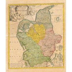
Tabula Generalis Jutiae.
Johan Baptist Homann (1663-1724). Outstanding German cartographer. Founder of the Homann publishing house. After the death of the son Johann Christoph, the firm continued...
Date: Nurnberg, 1714
Selling price: ????
Please login to see price!
Sold
Anatomical print.
Decorative and rare full-page anatomical copperplate engraving by Giulio de' Musi after a drawing by Eustachius and Pier Matteo Pini. From Tabulae anatomicae..In 1552, wi...
Date: Rome, Francesco Gonzaga, 1714
Selling price: ????
Please login to see price!
Sold
Anatomical print. TAB. XXIX.
Decorative and rare full-page anatomical copperplate engraving by Giulio de' Musi after a drawing by Eustachius and Pier Matteo Pini. From Tabulae anatomicae..In 1552 wit...
Date: Rome, Francesco Gonzaga, 1714
Selling price: ????
Please login to see price!
Sold

Anatomical print. TAB.XXIV.
Decorative and rare full-page anatomical copperplate engraving by Giulio de' Musi after a drawing by Eustachius and Pier Matteo Pini. From Tabulae anatomicae..In 1552 wit...
Date: Rome, Francesco Gonzaga, 1714
Selling price: ????
Please login to see price!
Sold
Anatomical print. TAB. XXXVI.
Decorative and rare full-page anatomical copperplate engraving by Giulio de' Musi after a drawing by Eustachius and Pier Matteo Pini. From Tabulae anatomicae..In 1552 wit...
Date: Rome, Francesco Gonzaga, 1714
Selling price: ????
Please login to see price!
Sold
Anatomical print. TAB. XXXII.
Decorative and rare full-page anatomical copperplate engraving by Giulio de' Musi after a drawing by Eustachius and Pier Matteo Pini. From Tabulae anatomicae..In 1552 wit...
Date: Rome, Francesco Gonzaga, 1714
Selling price: ????
Please login to see price!
Sold
Anatomical print.
Decorative and rare full-page anatomical copperplate engraving by Giulio de' Musi after a drawing by Eustachius and Pier Matteo Pini. From Tabulae anatomicae..In 1552 wit...
Date: Rome, Francesco Gonzaga, 1714
Selling price: ????
Please login to see price!
Sold
Anatomical print. TAB. XXXXIV.
Decorative and rare full-page anatomical copperplate engraving by Giulio de' Musi after a drawing by Eustachius and Pier Matteo Pini. From Tabulae anatomicae..In 1552 wit...
Date: Rome, Francesco Gonzaga, 1714
Selling price: ????
Please login to see price!
Sold

Anatomical print. TAB. XXXIX.
Decorative and rare full-page anatomical copperplate engraving by Giulio de' Musi after a drawing by Eustachius and Pier Matteo Pini. From Tabulae anatomicae..In 1552 wit...
Date: Rome, Francesco Gonzaga, 1714
Selling price: ????
Please login to see price!
Sold

Anatomical print. TAB. XX.
Decorative and rare full-page anatomical copperplate engraving by Giulio de' Musi after a drawing by Eustachius and Pier Matteo Pini. From Tabulae anatomicae..In 1552 wit...
Date: Rome, Francesco Gonzaga, 1714
Selling price: ????
Please login to see price!
Sold
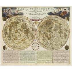
Tabula Selenographica..Hevelii quam Riccioli..
An uncommon, extremely decorative chart of the surface of the moon divided in hemispheres, from the famous "Atlas Coelestis" of Johann Gabriel Doppelmayr. Doppe...
Date: Nuremberg 1702-1714
Selling price: ????
Please login to see price!
Sold
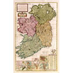
A new map of Ireland devided into its provinces..
A good copy of this very decorative and detailed large scale map. 12 inset plans of the towns of Dublin, Cork, Kinsale, Limerick, Waterford and Galway, and of the Giants'...
Date: London 1714
Selling price: ????
Please login to see price!
Sold
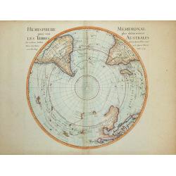
Hemisphere Meridional pour voir plus distinctement les Terres Australes
Map of the Southern Hemisphere with many voyage routes, including Magellan, Halley, Dampier and Tasman. A number of islands have only recently been discovered and are sho...
Date: Paris, 1714
Selling price: ????
Please login to see price!
Sold in 2008
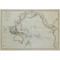
Océanie, ou Australasie et Polynésie . .
Beautiful large map of the Pacific Ocean. The many discoveries in the late 18th century in the northern part of North America and elsewhere have been incorporated, and t...
Date: Paris, 1714
Selling price: ????
Please login to see price!
Sold in 2008

Provincia Di Terra d'Otranto . . .
In lower left hand corner a large ornamental title cartouche. A decorative map of the Otranto region in Italy, based on the reports of Giacomo Cantelli da Vignola and pub...
Date: Rome, ca. 1714
Selling price: ????
Please login to see price!
Sold
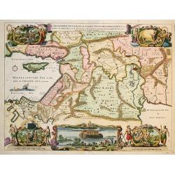
De Gelegentheyt van 't Paradys en 't Landt Canaan..
This Dutch Bible "carte à figures" map was published by Pieter & Jacob Keur. It covers the region between the Mediterranean and the Persian Gulf, depicting...
Date: Amsterdam, 1714
Selling price: ????
Please login to see price!
Sold in 2009
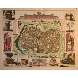
Jerusalem
Plan of ancient Jerusalem from a Dutch bible. At the top the Temple as a Renaissance palace, at left and right Biblical figures and Temple vessels.
Date: Amsterdam 1714
Selling price: ????
Please login to see price!
Sold in 2010
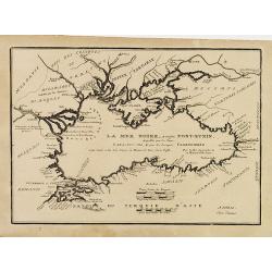
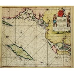
(LA MER NOIRE, Autrefois PONT-EUXIN, . . .)
Maps of the region Black sea, showing the cities of Constantinople, Heraclee, Kafa. From his 'Atlas Curieux'.Accomplanied by an engraved text sheet "Description de l...
Date: Paris, 1714
Selling price: ????
Please login to see price!
Sold in 2010
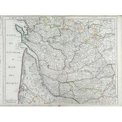
Carte du Bourdelois du Perigord et des Provinces voisines. . .
Finely detailed map of the Bordeaux region of France by Guillaume de L'Isle. Shows the French coast at the Bay of Biscay, the Garonne River and the port city of Bordeaux....
Date: Paris, 1714
Selling price: ????
Please login to see price!
Sold in 2010
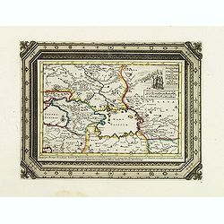
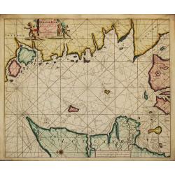
Zee en Landtogt door A. Jenkinson van Astracan Gedaan na Tartarien en terug tot in Moscow
A map of the lands around the Black Sea and the Caspian Sea, illustrating the travels of A. Jenkinson. Decorated with a nice title-cartouche.Although not renowned for the...
Date: Leiden, 1714
Selling price: ????
Please login to see price!
Sold in 2011
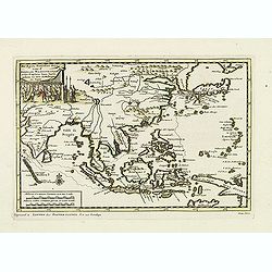
De Agste Oostinische Reys voor d' Engelze Maatschappie onder Kapitein Joan Saris, gedaan na Java, de Moluccas en Japan.
Map of the route of the English captain Joan Saris to Japan.Although not renowned for the originality of his work, Pieter van der Aa is highly thought of for the design a...
Date: Leiden, 1714
Selling price: ????
Please login to see price!
Sold in 2011
![[No tittle] Dardannelles](/uploads/cache/29095-250x250.jpg)
[No tittle] Dardannelles
Engraving presenting 4 views of Dardanelles from the standard work "Cornelis de Bruins Reizen over Moskovie, door Persie en Indie ".
Date: Amsterdam, R. en G. Wetstein, 1714
Selling price: ????
Please login to see price!
Sold in 2012
![[Title page] Atlas historique Tome IV. . .](/uploads/cache/31598-250x250.jpg)
[Title page] Atlas historique Tome IV. . .
Frontispiece from volume IV of the monumental "Atlas Historique" that was published in 1714. Northern Europe is allegorised with sleeping bears, stormy weather,...
Date: Amsterdam, 1714
Selling price: ????
Please login to see price!
Sold in 2011
Carte Particuliere des environs de Roermonde, Venlo, le Mararais de Peel, &c.
Detailed map of the area of Roermond, Venlo, Eindhoven. Prepared by E.H.Frix.
Date: Amsterdam 1715
Selling price: ????
Please login to see price!
Sold
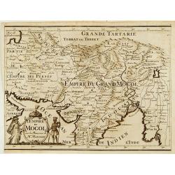
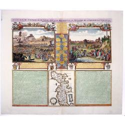
L'Empire du Mongol sur les Memoires de Mr. Manchouri.
Map of Empire of the Mogol from Memoirs of Mr. Manouchi (Manucci) . Published in Histoire Generale de l´Emppire du Mogol depuis sa Fondation jusqu´a Present, sur les Me...
Date: Paris 1715
Selling price: ????
Please login to see price!
Sold
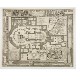
Plan du Saint Sepulchre..
Bird\'s-eye view of ancient Jerusalem. With 3 inset maps: \"Carte de la Terre Sainte...\", showing Holy Land with the route which Jesus took through Galilea, Sa...
Date: France, 1715
Selling price: ????
Please login to see price!
Sold in 2009
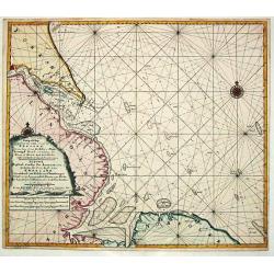
Paskaart vande West Kust van Jutland Van Busem tot aen 't Jutlandsche Riff.
A fine chart of the west coast of Schleswig-Holstein with the North Frisian Islands, Pelworm to Sylt and the west coast of Jutland. With a very large title-cartouche.From...
Date: Amsterdam 1715
Selling price: ????
Please login to see price!
Sold

COLLEGII REGALIS APUD CANTABRIGIENSES SACELLUM / KINGS COLLEGE CHAPPEL IN CAMBRIDGE
A large, superb profile of the famous Kings College Chapel of Cambridge University, as seen in the very early years of the 18th century. The title of the view is shown in...
Date: London, c. 1715
Selling price: ????
Please login to see price!
Sold
Paskaart van t' Schager-Rak Soo 't by de Oost-vaerende Zee Luyden gemeenlyk bezylt wordt.
The successful van Keulen firm published charts, pilot guides and sea-atlases for over 2 centuries. Founded by Johannes van Keulen, his son Gerard led the firm to its zen...
Date: Amsterdam, 1715
Selling price: ????
Please login to see price!
Sold
Paskaart Voor een gedeelte van de Oost-Zee. Beginnende van Schenkkenes tot aan Stokholm.
The successful van Keulen firm published charts, pilot guides and sea-atlases for over 2 centuries. Founded by Johannes van Keulen, his son Gerard led the firm to its zen...
Date: Amsterdam, 1715
Selling price: ????
Please login to see price!
Sold
Pascaart Om door de Sond En de Droogen te Seylen Stekkende van Kol tot Meun.
The successful van Keulen firm published charts, pilot guides and sea-atlases for over 2 centuries. Founded by Johannes van Keulen, his son Gerard led the firm to its zen...
Date: Amsterdam, 1715
Selling price: ????
Please login to see price!
Sold
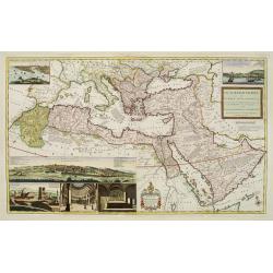
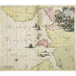
The Turkish Empire in Europe, Asia and Africa..
A fascinating, very decorative map of Turkey, the Arabian peninsular, the Mediterranean and countries bordering. The map is covered with detailed annotations, and has lar...
Date: London 1715
Selling price: ????
Please login to see price!
Sold
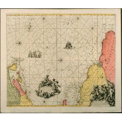
Nieuwe Paskaart van de Orcades Eylanden
The successful van Keulen firm published charts, pilot guides and sea-atlases for over 2 centuries. Founded by Johannes van Keulen, his son Gerard led the firm to its zen...
Date: Amsterdam, 1715
Selling price: ????
Please login to see price!
Sold in 2010
Facies Palaestinae Ex Monumentis Veteribus descripta ab Hadriano Relando.
Map of Iudaea, Samaria and Galilaea, with decorative inset of three figures overlooking a bay with a city in the background.Prepared by H.Reland (1676-1718) a professor a...
Date: Amsterdam 1715
Selling price: ????
Please login to see price!
Sold
L'Isle de Jan Mayen / La poincte Nordouest / Beerenberg.
The successful van Keulen firm published charts, pilot guides and sea-atlases for over 2 centuries. Founded by Johannes van Keulen, his son Gerard led the firm to its zen...
Date: Amsterdam, 1715
Selling price: ????
Please login to see price!
Sold
![[Varsovie]](/uploads/cache/24496-250x250.jpg)
[Varsovie]
Bird's eye-view of Warsaw. With a smaller frontal view of the town in the lower part and 2 insets in the upper corners illustrating Louwitz or Lowicz Castle. Engraved by ...
Date: Paris, ca. 1715
Selling price: ????
Please login to see price!
Sold in 2008
Nieuwe Paskaert Vande oost Cust van Engeland en Schotland. Beginnende van 't Flamburger Hooft tot aan de Rivier van Eedenborg. Inset: The River Tyne.
The successful van Keulen firm published charts, pilot guides and sea-atlases for over 2 centuries. Founded by Johannes van Keulen, his son Gerard led the firm to its zen...
Date: Amsterdam, 1715
Selling price: ????
Please login to see price!
Sold in 2008
Nieuwe Wassende Gradige Pas-kaart van een gedeelte der oost-kust van Engeland, Strekkende van Eckles tot Flambrouger Hooft , in zig begrypende de Rievier van Hull.
The successful van Keulen firm published charts, pilot guides and sea-atlases for over 2 centuries. Founded by Johannes van Keulen, his son Gerard led the firm to its zen...
Date: Amsterdam, 1715
Selling price: ????
Please login to see price!
Sold in 2011
La Baye d' Hollande ou de Maurits / Baye de Magdaleine.
The successful van Keulen firm published charts, pilot guides and sea-atlases for over 2 centuries. Founded by Johannes van Keulen, his son Gerard led the firm to its zen...
Date: Amsterdam, 1715
Selling price: ????
Please login to see price!
Sold in 2019
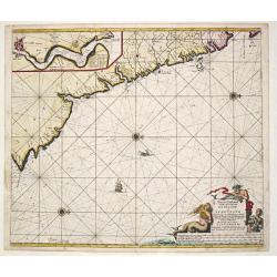
Terra Neuf, en de Custen van Nieu Vranckryck, Nieu Engeland, Nieu Nederland, Nieu Andalusia, Guiana en Venezuela
L. Renard's edition of Frederick de Wit's magnificent Atlantic chart oriented to the East. From the 1715 edition of "Atlas de la Navigation et du Commerce". A f...
Date: Amsterdam, 1715
Selling price: ????
Please login to see price!
Sold in 2012
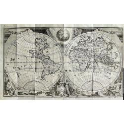
Orbis Terrarum Nova et Accuratissima Tabula
Superb double-hemisphere copper engraved map of the world. Shows California as an island, large \"Compagnies Land\" between the Asian and American continents, a...
Date: Leiden, c1715
Selling price: ????
Please login to see price!
Sold in 2008
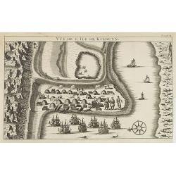
Vüe de l'Ile de Kilduyn.
A view of the Kilduyn Island on the Kola River in Russia. In upper right corner "To. 3. pa.24."The Kola River in the northern part of the Kola Peninsula...
Date: 1715
Selling price: ????
Please login to see price!
Sold in 2009
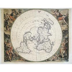
Orbis Per Creationem Institutus. . .
An uncommon Dutch Bible map of the Middle East and Holy Land, including a map of Paradise, a map of the Exodus, a map of Israel divided among the Tribes, a map of Canaan,...
Date: 1715
Selling price: ????
Please login to see price!
Sold in 2010
Planisphere Terrestre Suivant les nouvelle Observations des Astronomes Dressee et presente Roy Tres Chretien par Mr. Cassini...
Karpinski considers this the first strictly scientific map of the world. This was the first map to set standard longitudes for known places based on scientific calculatio...
Date: Leiden, c. 1715
Selling price: ????
Please login to see price!
Sold in 2016
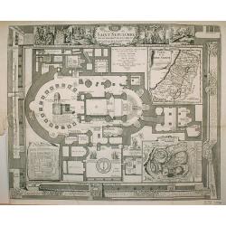
Plan du Saint Sepulchre..
Bird's-eye view of ancient Jerusalem. With 3 inset maps: "Carte de la Terre Sainte...", showing Holy Land with the route which Jesus took through Galilea, Samar...
Date: France 1715
Selling price: ????
Please login to see price!
Sold in 2009
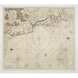
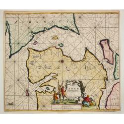
Russiae et Novae Zemblae Maritimae.
Splendid sea-chart of the Barents Sea coast from Murmansk to Novaya Zemlya. The chart is embellished with sailing ships, whaling scenes. In the upper right corner a title...
Date: Amsterdam, 1715
Selling price: ????
Please login to see price!
Sold in 2009
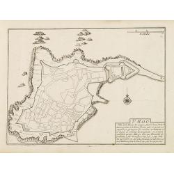
St. Malo
Fortification town-plan of St. Malo in Brittany. Wind rose and explanatory panel in lower right corner.Nicolas de Fer [1646-1720] was one of the most prolific and influen...
Date: Paris, 1715
Selling price: ????
Please login to see price!
Sold
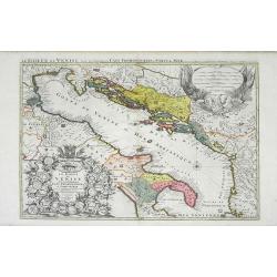
Le Golfe de Venise Avec ses Principaux Caps Promontiores & Ports de Mer. . .
Map of the Gulf of Venice also known as the Adriatic Sea by Sanson and published by Covens and Mortier. The colored areas include southern Italy to the west and Dalmatie ...
Date: Amsterdam, c. 1715
Selling price: ????
Please login to see price!
Sold in 2010
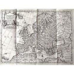
L'EUROPE suivant les Nouvelles Observations...
Charming map of Europe, including parts of North Africa, the Near East, and Russia. Very detailed map with many place names (cities, rivers, lakes, islands, etc). Decorat...
Date: Leiden, c.1715
Selling price: ????
Please login to see price!
Sold in 2011
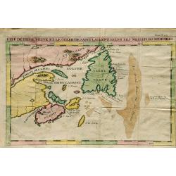
L'Ile De Terre Neuve Et Le Golfe De Scint Laurent Selon Les Meilleurs Memoires.
A well engraved chart that details the sea around the outlet of the St. Laurence River and the Gulf of St. Lawrence, Newfoundland, Canada. Made by J.F. Bernard, and publi...
Date: Amsterdam, 1715
Selling price: ????
Please login to see price!
Sold in 2019
SUCCESSION DES EMPEREURS DU JAPON AVEC UNE DESCRIPTION du MEURTRE DE L'EMPEREUR CUBO ET LA.
The plate is showing the murder of the Emperor Cubo at Kyoto, and the arrival of one of the early Dutch Ambassadors to Japan. A small map of Honshu in a central panel. Fr...
Date: Amsterdam, 1715
Selling price: ????
Please login to see price!
Sold in 2020
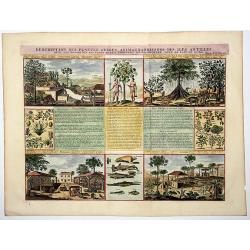
Descriptions des Plantes, Arbres, Animaux & Poissons des Iles Antilles.
An interesting sheet with eight detailed views illustrating fauna and flora on the Antillean islands, and how the slaves make sugar, with descriptive French text, from Ch...
Date: Amsterdam, 1715
Selling price: ????
Please login to see price!
Sold in 2020
![[Varsovie].](/uploads/cache/45606-250x250.jpg)
[Varsovie].
Bird's eye-view of Warsaw. With a smaller frontal view of the town in the lower part and 2 insets in the upper corners illustrating Louwitz or Lowicz Castle. Engraved by ...
Date: Paris, ca. 1715
Selling price: ????
Please login to see price!
Sold in 2020
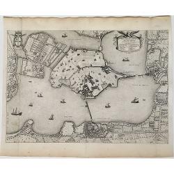
Ville et Environs de Mantoue.
An extremely detailed city map of Mantova in Lombardia, published by Pierre Mortier, after Blaeu. An attractive birds-eye view including all the city's main buildings, in...
Date: Amsterdam, 1704/1715
Selling price: ????
Please login to see price!
Sold in 2022
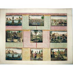
VUE & DESCRIPTION DE LA VILLE DE SIAM . . .
A copper engraved sheet with set of 9 decorative views of Thailand, including the king of Siam riding on his elephant. A very decorative item ! - It features the capital ...
Date: Amsterdam, ca 1715
Selling price: ????
Please login to see price!
Sold in 2021

Habillemens Des Dames de Constantinople, des Dames du Serrail & Ianissaires.
A large copper engraved sheet with decorative set of images on the costumes of the women and Janissaries of Turkey, from Chatelain's monumental 7 volume 'Atlas Historique...
Date: Amsterdam, ca 1715
Selling price: ????
Please login to see price!
Sold in 2021
![[Title page] Planisphere representant tout e l'etendue du monde. . .](/uploads/cache/31980-250x250.jpg)
[Title page] Planisphere representant tout e l'etendue du monde. . .
Atlas carries a north polar azimuthal projection on his shoulders. This projection with equidistant concentric circle of latitude was claimed by Louis de Mayerne Turquet....
Date: Amsterdam, 1715
Selling price: ????
Please login to see price!
Sold in 2012
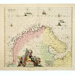
Finmarchae et Laplandiae Maritima. / Nieuwe Pascaert vande Kusten Finmarcken en Lapland Streckende van Dronten tot Archangel.
An eye-catching chart of Barents Sea and White Sea (with Archangelsk) with the coast of Norway, Lapland and peninsula Kola.. Coastal cities, bodies of water and islands a...
Date: Amsterdam, 1715
Selling price: ????
Please login to see price!
Sold in 2012
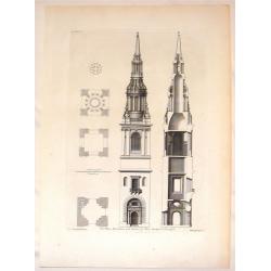
The Plans, Elevations and Section of Bon-Steeple in Cheapside.
Stiking steel engraving of the steeple in Cheapside. A fine example of a Vitruvius Britannicus print. Colen Campbell (1676–1729) was a pioneering Scottish architect an...
Date: London, 1715
Selling price: ????
Please login to see price!
Sold in 2016
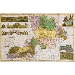
Oxford Shire Actually Survey'd &c. . .
Scarce extensive county map, north oriented to the right. With an elaborate title cartouche, 5 inset views of "The Prospect of Oxford," "The Theatre,"...
Date: London, 1715
Selling price: ????
Please login to see price!
Sold in 2015
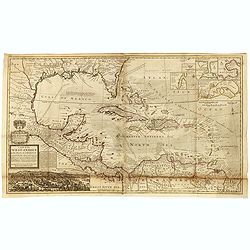
A Map of the West-Indies or the Islands of America in the North Sea with ye adjacent Countries; explaining what belongs to Spain, England, France, Holland &c. . . .
Herman Moll's map of the Caribbean, Florida, the Gulf Coast, Texas, Central America etc. Decorated with insets of the harbors at St. Augustine, Vera Cruz, Havana, Porto B...
Date: London, ca. 1715
Selling price: ????
Please login to see price!
Sold in 2016
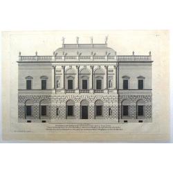
Vitruvius Britannicus (House plan for the Duke of Argyle in the Style of Indigo Jones)
Fine house design in the style of Indigo Jones. Engraved by Colen Campbell and presented to the Duke of Argyle.
Date: London, 1715
Selling price: ????
Please login to see price!
Sold in 2021
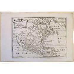
Amerique Septentrionale.
Interesting 1715 quarto-size copy of Sanson's important map of North America, typically found in editions of L'Amerique published from 1656 to 1683. This copy from Chemer...
Date: Utrecht, 1715
Selling price: ????
Please login to see price!
Sold in 2015
![[Varsovie].](/uploads/cache/37246-250x250.jpg)
[Varsovie].
Bird's eye-view of Warsaw. With a smaller frontal view of the town in the lower part and 2 insets in the upper corners illustrating Louwitz or Lowicz Castle. Engraved by ...
Date: Paris, ca. 1715
Selling price: ????
Please login to see price!
Sold in 2016
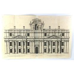
Elevation of One of the Double Pavillions of the Royall Hospital att Greenwich to the River
A fine copper plate engraving, published in about 1715 in London. From the "VITRIUS BRITANNICUS" by Colen Campbell. Colen Campbell (1676 -1729) was a pioneering...
Date: London, 1715
Selling price: ????
Please login to see price!
Sold in 2016
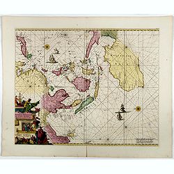
Orientaliora Indiarum Orientalium..C.Comorin ad Iapan.
The uncommon Louis Renard edition. - A superb late 17th century Dutch sea-chart of Australia and the East Indies, closely modelled on Pieter Goos' chart of 1666. The char...
Date: Amsterdam, 1680-1715
Selling price: ????
Please login to see price!
Sold in 2016
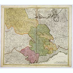
Regiae Celsitudinis Sabaudicae. . .
A detailed map of the Piedmont region in Northern Italy. The major cities of Torino, Milan, and Genoa and Geneva, Switzerland are all shown. Johann Baptist Homann was a G...
Date: Nuremberg, ca. 1715
Selling price: ????
Please login to see price!
Sold in 2017
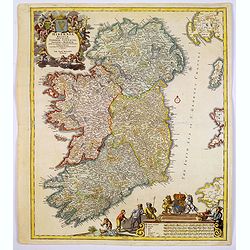
Hiberniae regnum. . .
A detailed and decorative map of Ireland, colored by the 4 regions and showing the towns, roads, counties, rivers, lakes, castles, etc. Includes a pair of lovely cartouch...
Date: Nurnberg, 1715
Selling price: ????
Please login to see price!
Sold in 2017