Browse Listings
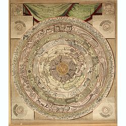
Veritable Representation des Premieres Matieres ou Elements avec leurs Directions. . .
A very rare double-page engraved circular representation of the world depicted in circular layers with Hell at its core, consisting of 9 concentric circles including the ...
Date: Haarlem, 1650 - 1700
Selling price: ????
Please login to see price!
Sold in 2014
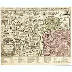
CARTE QUI REPRESENTE TOUTES LES PIECES QUI SONT COMPRISE DANS L'ARCHITECTURE MILITAIRE OU L'ART DES FORTIFICATIONS...
Attractive copper-engraved print of military objects, weapons, cannons, fortifications, buildings, ships, tools, etc. Includes an extensive key with more than 84 descript...
Date: Amsterdam, 1700
Selling price: ????
Please login to see price!
Sold in 2015
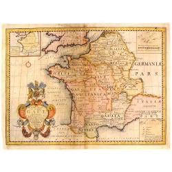
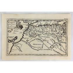
A New Map of Ancient Gaul or Gallia Transalpina.
A striking map of Ancient France during the time of Augustus Caesar. Includes a wonderful large title cartouche that includes fruit, ribbons and the Gloucester coat of ar...
Date: Oxford, 1700
Selling price: ????
Please login to see price!
Sold in 2017
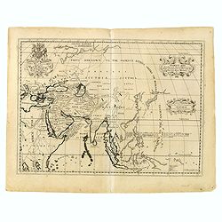
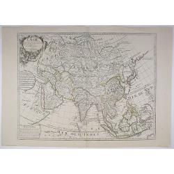
Ancient Asia.
Map of ancient Asia engraved by Michael Burghers of Oxford University. Dedicated to the Duke of Gloucester.With several interesting legends, a legend in the vicinity of t...
Date: Oxford, 1700
Selling price: ????
Please login to see price!
Sold in 2015
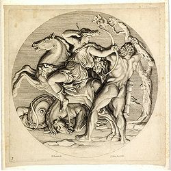
(Hercules and Hippolyte, Queen of the Amazons.)
PROOF. Engraving by Jean Pesne (1623–1700) after Nicolas Poussin (1594-1665), showing Hercules and Hippolyte (Queen of the Amazons.) Proof state before title "Herc...
Date: Paris, ca. 1700
Selling price: ????
Please login to see price!
Sold in 2015
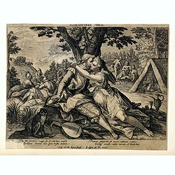
Scortatores.
Engraving by Crispin de Passe the Younger (Dutch, 1593–1670) and published by his father Crispijn de Passe the Elder (circa 1565-1637) who was an engraver, draughtsman ...
Date: Antwerp, c.1700
Selling price: ????
Please login to see price!
Sold in 2016
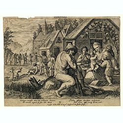
Coniuges (marriage partners)
Engraving by Crispin de Passe the Younger (Dutch, 1593–1670) after and published by his father Crispijn de Passe the Elder (circa 1565-1637) who was an engraver, draugh...
Date: Antwerp, c.1700
Selling price: ????
Please login to see price!
Sold in 2016
The East & West Prospect of Bushey Hall.
A very detailed plan of Bushey Hall with even the people quite detailed. It was published by Sir Henry Chauncy in "HISTORICAL ANTIQUITIES OF HERTFORDSHIRE" in 1...
Date: London, 1700
Selling price: ????
Please login to see price!
Sold in 2019
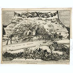
Plan exact des fortifications du Château de Choczim sur le Niester : avec le forts et retranchements de l'Armée des Turcs, défaite en 1673 par Jean Sobieski. . .
Depicting the victory of Jan Sobieski over the Turks at Khotyn in Ukraine in 1673. The victory allowed the Poles to revoke the unfavorable Peace of Buczacz and set the st...
Date: Leiden, P. van der AA, ca. 1700
Selling price: ????
Please login to see price!
Sold in 2015
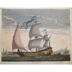
Polacre a la voille.
Scarce copper-engraved illustration of a 17th century sailing ship. Fantastic view with sailors working on the ship with full sails, cannons, etc. With a second ship, and...
Date: Amsterdam, 1693-1700
Selling price: ????
Please login to see price!
Sold in 2015
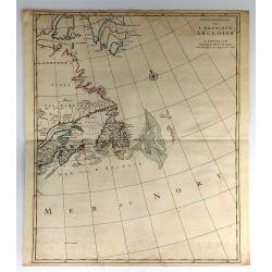
Partie Orientale de l'Amérique Angloise.
This is the eastern half of Mortier's two-sheet map of the eastern United States and Canada: "Carte Nouvelle de l'Amerique Angloise. This sheet, focusing almost all ...
Date: Amsterdam, 1700
Selling price: ????
Please login to see price!
Sold in 2016
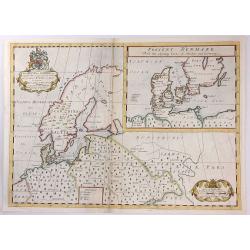
A New Map of Ancient Scandinavia together with as much more of y Northern Part of Ancient Europe as Anvers to Present Denmark & Moscovia
A map of Scandinavia, with an inset map of “Present Denmark”, from Edward Wells' "A New Sett Of Mapps Of Ancient And Present Geography ...". The engraver of...
Date: Oxford, 1700
Selling price: ????
Please login to see price!
Sold in 2018
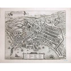
Neapolis
A magnificent, large view of Naples. Rare. Son of the cartographer and publisher Frederick de Wit (1610-1698), he bought plates of Jansson’s "Town Plans", iss...
Date: Amsterdam, ca 1700
Selling price: ????
Please login to see price!
Sold in 2017
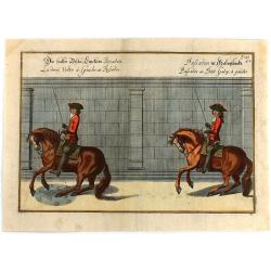
Passades au Petit Galop a Gauche.
This striking copperplate engraving after Abraham van Diepenbeeck , shows the Duke of Newcastle demonstrating how gallop to the left. It is from Cavendish’s exposition ...
Date: Frankfurt, 1700
Selling price: ????
Please login to see price!
Sold in 2016

Title Page from Jacob Cats' Emblem Book.
A lovely allegorical title page from Jacob Cats’s emblem book. A Dutch edition, published in 1700 by Daniel van den Dalen. It includes many figures including: musicians...
Date: Amsterdam, 1700
Selling price: ????
Please login to see price!
Sold in 2016
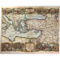
De Beschryving van de Reysen Pauli, en van de Andere Apostelen...
A beautiful map by Jan Van Den Avelen of the Eastern Mediterranean region, detailing the travels of the Apostle Paul. Richly decorated with scenes from St. Paul's travels...
Date: Amsterdam, 1700
Selling price: ????
Please login to see price!
Sold in 2016
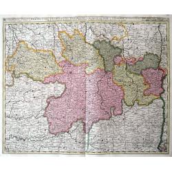
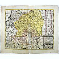
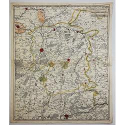
Cercle de la Souabe Septentrionale.
A detailed map by Pierre van der Aa of the German province of Soube, following the new observations of the “Academie Royale des Sciences”. It has a beautiful cartouch...
Date: Amsterdam, 1700
Selling price: ????
Please login to see price!
Sold in 2019
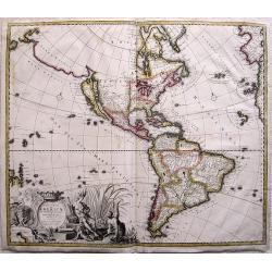
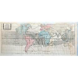
Recentissima Novi Orbis sive Americae Septentrionalis et Meridionalis Tabula ex officina Caroli Allard . . .
Map of estern hemisphere by Carol Allard (1614-1709); drawn by Ph.Tideman, engraved G. van Gouwen. from: Atlas Minor', published Amsterdam, c1700. 3rd state with climates...
Date: Amsterdam, ca. 1700
Selling price: ????
Please login to see price!
Sold in 2016
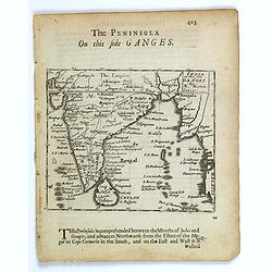
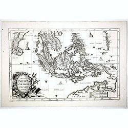
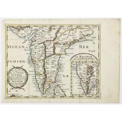
The Penisula on this side Ganges.
This map appeared in Modern's rare 'Atlas Terestris', first published in 1687. This map is the uncommon English text map of India, Ceylon, the Maldives and the Malaya Pen...
Date: London, 1700
Selling price: ????
Please login to see price!
Sold in 2016
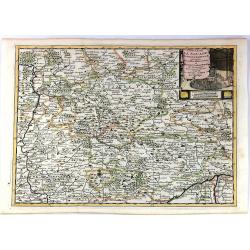
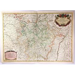
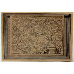
Praefectura Lugunensis Generalis...
A very detailed map of a part of South-Central France, centred on the former Auvergne region. Includes the cities of Périgueux, Limoges, Clermont-Ferrand, Montelimar, M�...
Date: Amsterdam, ca 1700
Selling price: ????
Please login to see price!
Sold in 2016
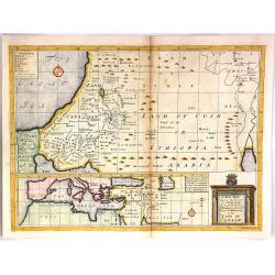
A New Map Shewing the Travels of the Patriarchs.
A fine engraved map of the land of Canaan (Current day Ethiopia and Arabia). At the bottom is a separate map of of "The Great Sea" (Mediterranean". The tit...
Date: London, 1700
Selling price: ????
Please login to see price!
Sold in 2018
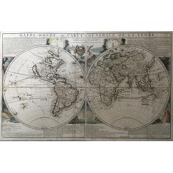
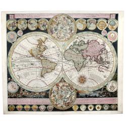
Mappe-Monde, ou Carte Generale de la Terre, Divisee en Deux Hemispheres Suivant la Projection la Plus Commune ou Tous les Points Principaux sont Placez sur les Observations de Mrs. de l'Academie Royale des Siences
A copper-engraved double-hemisphere map, hand-colored in outline, with colored pictorial representations as background, engraved text at top and bottom.A rare first state...
Date: Paris, 1700
Selling price: ????
Please login to see price!
Sold in 2017
La Lorraine, qui Comprend les Duches de Lorraine et de Bar.
A handsome map of the Lorraine region of France. It includes the cities of Metz, Verdun and Nancy. The topography is detailed with trees, mountains and cities dotting th...
Date: Paris, 1700
Selling price: ????
Please login to see price!
Sold in 2016
![[Forteza di Catara]](/uploads/cache/36186-250x250.jpg)
[Forteza di Catara]
Uncommon print of the town of Kotor (citta di Cataro) in Montenegro.
Date: Italy, ca. 1700
Selling price: ????
Please login to see price!
Sold in 2016
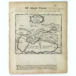
Tartaria in Europe.
This map appeared in Modern's rare 'Atlas Terestris', first published in 1687, depicting the regions surrounding the Black Sea.It features a pleasant scrolled title carto...
Date: London, 1700
Selling price: ????
Please login to see price!
Sold in 2016
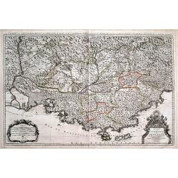
Le Comté et Gouvernement de Provence, divisée en ses vigueries...
Large scale map of Provence with immense detail after Sanson. Extends from Montélimar, Arles, and the Carmargue in the East, until Nice and Stroppo near Cuneo in the Wes...
Date: Amsterdam, ca. 1700
Selling price: ????
Please login to see price!
Sold in 2016
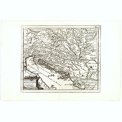
Veteris et Nova Pannoniae et Illyrici Descriptio.
A map of the north Balkans and northern Adriatic in ancient times. The map is based on the earlier Ortelius map of the same name. From Italy to Greece and inland to Morav...
Date: Amsterdam, ca. 1700
Selling price: ????
Please login to see price!
Sold in 2019
Magni ducatus Lithuaniae Caeterarumq Regionum illi adiacentium exacta descrip. . .
Highly detailed map of Lithuania and Belarus between Riga, Smolensk, Kiev, Cracow and Konigsberg, including two inset maps of the Dnieper River from Cherkasy to the Black...
Date: Amsterdam, 1700
Selling price: ????
Please login to see price!
Sold in 2016
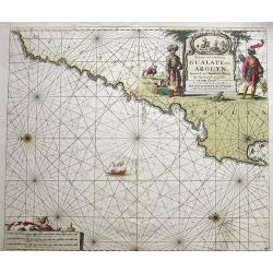
Paskaart van de Kuste van Gualate en Arguyn...
A very decorative seah-chart of the coastline of Western Sahara, between Cape Bojador and Ras Nouadhibou. Oriented to the east. With attractive hand-color, a sailing ship...
Date: Amsterdam, ca. 1680-1700
Selling price: ????
Please login to see price!
Sold in 2016
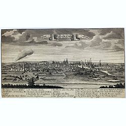
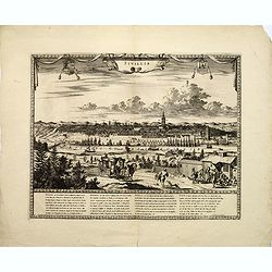
Moskow.
A rare view of Moscow.
Date: Germany, ca. 1700
Selling price: ????
Please login to see price!
Sold in 2017
Insulae Indicae cum terris circumvicinis..
An attractive map of South-East Asia published in the uncommon Atlas Novus by the German Jesuit scholar, Heinrich Scherer. The map extends from Ceylon to the north coast ...
Date: Munich, 1700
Selling price: ????
Please login to see price!
Sold in 2017
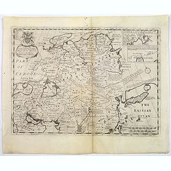
A New Map of Great Tartary and China with the adjoining parts of Asia...
Two insets showing the land to the north-east of China according to the Jesuits. Map stretches from northern Russia and Nova Zemlya in the north-west to Formosa in the so...
Date: Oxford, 1700
Selling price: ????
Please login to see price!
Sold in 2018
Sivillia.
A lovely large, decorative town view on the Andalusian capital city of Seville, by F. de Witt. With imposing and important buildings identified, the river Guadalquivir is...
Date: Amsterdam, ca 1700
Selling price: ????
Please login to see price!
Sold in 2017
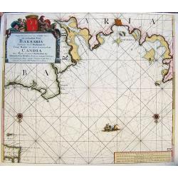
Nieuwe Pascaart voor een Gedeelte van de Zeekusten van Barbaria... Candia...
A very decorative sea-chart of the coastline of Libya, from Misurata to Crete. Curious shape of the coast with several cities shown. Oriented with south on the top. With ...
Date: Amsterdam, ca. 1680-1700
Selling price: ????
Please login to see price!
Sold in 2017
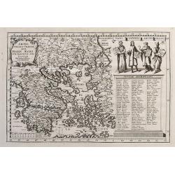
Archipelagi Graeciae Sive Maris Aegei Cum Praecipuis Suis Insulis...
A very detailed map of Greece and its islands. Includes also a portion of Turkey and South East Europe. With a table giving the ancient and modern names of all the island...
Date: Munich, ca.1700
Selling price: ????
Please login to see price!
Sold in 2017
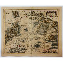
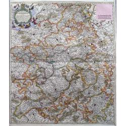
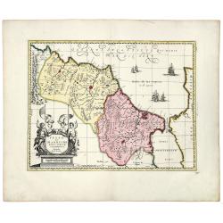
Wetteravia die Wetterau.
A detailed map of the Wetterau region of Germany to the northeast of Frankfurt/Main, centred on Friedberg, reaching to Hofheim, Weilburg, Giessen, the Vogelsberg mountain...
Date: Amsterdam, ca. 1700
Selling price: ????
Please login to see price!
Sold in 2019
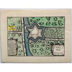
Plan du Fort de Rebus en Flandre.
A very fine map of the fortification of Rebus, in Flanders in northern Belgium. It features a drapery title cartouche and separate Information key.Nicolas de Fer (1646–...
Date: Paris, ca. 1700
Selling price: ????
Please login to see price!
Sold in 2017
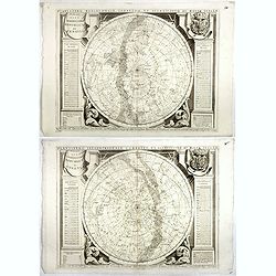
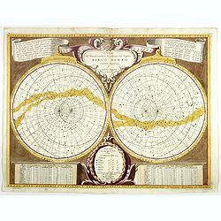
Planisfero Settentrionale Corretto, et Accreciuto . . .(together with) Planisfero Meridionale, Corretto, et Accrescuito . . .
Set of two decorative celestial charts of the Northern skies and southern skies.From Coronelli's "Corso Geographico". The constellations and the brightest stars...
Date: Venice, 1700
Selling price: ????
Please login to see price!
Sold in 2017
Quartier de Louain???
Unique map of Brabant, Belgium. Louain or Louen or Leuven is the capital of the province of Flemish Brabant in Belgium. It is located about 25 kilometres east of Brussel...
Date: Brabant, ca. 1700
Selling price: ????
Please login to see price!
Sold in 2018
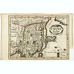
Chine.
The rare second state of this early map of China, Korea, and Japan. From "Nouvelle Geographie. . . Par Mr. D. Martineau Du Plessis... A Amsterdazm, Chez George Galle...
Date: Amsterdam, 1700
Selling price: ????
Please login to see price!
Sold in 2017
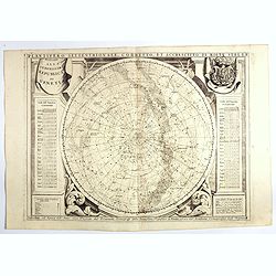
Planisfero Settentrionale Corretto, et Accreciuto di Molt..A
Decorative celestial chart of the Northern skies. The remarkable Vincenzo Coronelli (1650-1718), was a Franciscan Friar and appointed General of the Order in 1701. He was...
Date: Venice, 1700
Selling price: ????
Please login to see price!
Sold in 2020
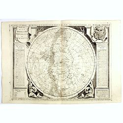
Planisfero Meridionale Corretto, et Accreciuto di Molt..
Decorative celestial chart of the Southern skies.The remarkable Vincenzo Coronelli (1650-1718), was a Franciscan Friar and appointed General of the Order in 1701. He was ...
Date: Venice, 1700
Selling price: ????
Please login to see price!
Sold in 2020
Planisferii Celesti, Calcolati Per L'Anno MDCC, Corretti, Et Aumenati Di Molte Stelle . . .
Double hemisphere celestial map showing a new and more scientific depiction of the heavens. In original colors, it is very unusual to find Coronelli maps in original colo...
Date: Venice, 1700
Selling price: ????
Please login to see price!
Sold in 2020
Mauritana et Africa Propria nunc Barbaria.
A nice engraved map of the north-western part of Africa with the Canary Islands by Phillip Clüver in about 1700. With one cartouche featuring an angel.Philipp Clüver (...
Date: Paris, ca 1700
Selling price: ????
Please login to see price!
Sold in 2018
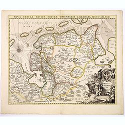
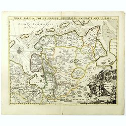
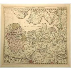
Nova Tabula Totius Frisiae Orientalis.
The map is a cooper engraved map of East Friesland by Carel Allard.
Date: Amsterdam, ca. 1700
Selling price: ????
Please login to see price!
Sold in 2017
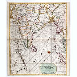
Carte particuliere d'une Partie d'Asie ou sont le Isles d'Andemaon, Ceylan, Les Maldives. . .
Intriguing map of India, Ceylon, Maldives and East Coast of Sumatra, and Malaysia. Sumatra peeks out of the eastern border, with the southwest peninsula showing the Kingd...
Date: Amsterdam, 1700
Selling price: ????
Please login to see price!
Sold in 2020
L'ASIE Dressée sur les Observations de l'Académie Royale des Sciences et quelques autres, et sur les mémoires les plus recens. . .
This is important and rare map of Asia, issued by Guillaume Delisle and with 3 nice decorative cartouches, engraved by N. Guerard. It includes the East Indies and the tip...
Date: Paris, 1700
Selling price: ????
Please login to see price!
Sold in 2019
Typus Generalis Ukrainae sive Palatinatuum Podoliae, Kioviensis et Braczlaviensis terras nova delineatione exhibens
Key map originally engraved by Johannes Janssonius in about 1656 and based on Guillaume La Vasseur de Beauplan's map of the region published in "Description d'Ukrain...
Date: Amsterdam, 1690 - 1700
Selling price: ????
Please login to see price!
Sold in 2020
Alexandri Magni Macedonis Expeditio.
An interesting historical map showing the region covered during the expeditions of Alexander the Great. With many details in Turkey, Near East, Middle East and Persia. Se...
Date: Amsterdam, 1652-1700
Selling price: ????
Please login to see price!
Sold in 2018
![L'Europa dedicata All'Illustris ed Eccel. Mo Sig.re D.Giovanni Milano... [Part of a wall map]](/uploads/cache/41454-250x250.jpg)
L'Europa dedicata All'Illustris ed Eccel. Mo Sig.re D.Giovanni Milano... [Part of a wall map]
Upper left sheet of a 4 sheet wall map of Europe. Published by Paolo Petrini. Petrini's maps are considered great rarities and are highly collectable.The map is centered ...
Date: Naples, 1700
Selling price: ????
Please login to see price!
Sold in 2018
Delphinatus Praefectura Quae Gallis audit Gouvernement de Daufine.
A very detailed, antique map of the Dauphiné in the southeast of France by G. Valk. On the left the Rhône from Lyon, Vienne, Tournon-sur-Rhône, Valence to Montélimar....
Date: Amsterdam, ca. 1700
Selling price: ????
Please login to see price!
Sold in 2018
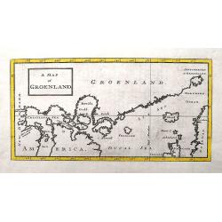
A Map of Groenland.
A scarce map of the southern coast of Greenland and the north Atlantic Ocean. The map is derived from Isaac la Peyrere's map of 1647. It locates Spitzberg, Iceland, the f...
Date: London, ca 1700
Selling price: ????
Please login to see price!
Sold in 2018
Carte Nouvelle Contenant la Partie D'Amerique la Plus Septentrionale ...
Fine example of the eastern part of Visscher's 2-sheet map of the Northeastern part of North America, first published in 1696. The map extends from Nova Scotia and Acad...
Date: Amsterdam, c1700
Selling price: ????
Please login to see price!
Sold in 2018
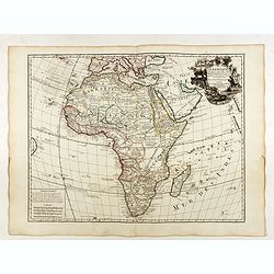
L'Afrique dressée sur les observations de Mr de l'Académie Royale des Sciences. . .
Rare second state with the address : Chez l’Auteur sur le Quai de l’Horloge a la Couro. e de Diamans avec Privilege du Roy pour 20 ans, 1700". Guillaume de l'Isl...
Date: Paris, 1700
Selling price: ????
Please login to see price!
Sold in 2018
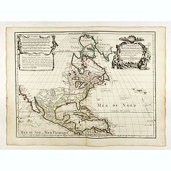
L'Amerique Septentrionale dressée sur les Observations de Mrs de l'Academie Royale des Sciences . . .
Rare third state of "L’Amerique Septentrionale. Chez l’Auteur sur le Quai de l’Horloge a la Cour. de Diamans avec Privilege du Roy pour 20 ans, 1700". &qu...
Date: Paris, 1700
Selling price: ????
Please login to see price!
Sold in 2018
Presqu Isle de L'Inde. deca la Gange.. .
Two maps together on one sheet.
Date: Amsterdam, 1700
Selling price: ????
Please login to see price!
Sold in 2018
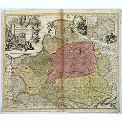
Frederico Augusto .. Polon. Lithuan. Borus. Pomer. Regi..
A decorative map and rare map of the Kingdom of Poland, which in the early eighteenth century included much of Ukraine, White Russia, and the Baltic States. There is an i...
Date: Amsterdam, 1700
Selling price: ????
Please login to see price!
Sold in 2018
Comté et Gouvernement general de Champagne ou sont la Vraye Champagne, la Brie, le Remois, Retelois, Senonois, la Pertois, Bassigny. . .
A large and detailed map of the Champagne region, a part of Luxembourg in the north, and Auxerre in the south. Filled with place names and topographical information. With...
Date: Amsterdam, ca 1700
Selling price: ????
Please login to see price!
Sold in 2018
Nova Tabula Totius Frisiae Orientalis.
The map is a copper engraved map of East Friesland in Germany by Carel Allard. It shows the North Sea coastal line of Friesland with Emden and the islands Borkum, Nordern...
Date: Amsterdam, ca. 1700
Selling price: ????
Please login to see price!
Sold in 2018
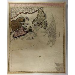
![[Map of Scandinavia] La Scandinavie, et les Environs.](/uploads/cache/82018-250x250.jpg)
[Map of Scandinavia] La Scandinavie, et les Environs.
An attractive large-format map of Scandinavia. Embellished with two cartouches by Jaillot, H-J.
Date: Paris, ca 1700
Selling price: ????
Please login to see price!
Sold in 2019
La Moscovie Meridionale...
Detailed map centered on area north of Moscow, including part of Finland and Lapland. Charming title cartouche in lower right corner. This well executed engraving was pu...
Date: Leiden, 1700
Selling price: ????
Please login to see price!
Sold in 2018
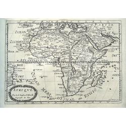
Afrique.
An interesting map of Africa. Shows the area from Brazil until Arabia, including the Canary and Cape Verde Islands, as well as Tristan da Cunha. The interior of the conti...
Date: Paris, ca 1700
Selling price: ????
Please login to see price!
Sold in 2018
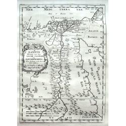
Egypte divisée en ses Douze Cassilifs. . .
A fine map of Egypt with parts of the Red Sea and Israel. Very detailed representation of the Nile River Valley, showing major cities, mountains and oases.
Date: Paris, ca 1700
Selling price: ????
Please login to see price!
Sold in 2018
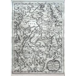
Partie de La Haute Aethiopie ou sont L'Empire des Abissins et la Nubie, & c.
An excellent map of the Nile with its mythical sources. Shows the Nile River from Zaire Lake and Zaflant Lake, until Assuan (Aswan). Richly detailed with place names, hil...
Date: Paris, ca 1700
Selling price: ????
Please login to see price!
Sold in 2020
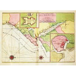
Carte Particuliere de la Mer Rouge &c.
An attractive sea chart of the Red Sea, Africa's Indian ocean coast from the Red Sea to Mozambique and the southwest coast of Arabia. With insets of Mombassa and fort and...
Date: Amsterdam, 1700
Selling price: ????
Please login to see price!
Sold in 2020
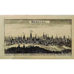
Brussel.
A miniature city view of Brussels, Belgium. It has a key to the main buildings along the bottom of the engraving. This print is not available now nor has been in the past...
Date: UNKNOWN, ca 1700
Selling price: ????
Please login to see price!
Sold in 2019
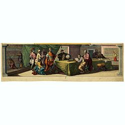
(Geographic scholars at work in a library are depicted )
Clipping from a title page "Table Des Cartes etc: Du Sr. Sanson…", in fine original colors.
Date: Amsterdam, 1700
Selling price: ????
Please login to see price!
Sold in 2022
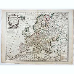
Carte de l'Europe Dressée sur les observations de Mrs de l'Academie Royale des Sciences . . .
An early and scarce state of "L’Europe. Chez l’Auteur sur le Quai de l’Horloge a la Couronne de Diamans, 1700".The finely engraved map shows Europe divide...
Date: Paris, 1700
Selling price: ????
Please login to see price!
Sold in 2025
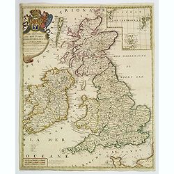
Les Isles Britanniques. . .
J.B. Nolin's map of the British Isles, based on the work of Coronelli. Map features an inset of the Orkney, Shetland and Faroe Islands. A splendid title cartouche adorns ...
Date: Paris, ca 1700
Selling price: ????
Please login to see price!
Sold in 2020
Flandriae Comitatus Pars Batava.
Fine detailed map of Flanders featuring the cities of Middleburg, Hulst, Dendermonde and Gent. It has very precise original coloring. By Visscher in Amsterdam.Nicolaes ...
Date: Amsterdam, c1700
Selling price: ????
Please login to see price!
Sold in 2020
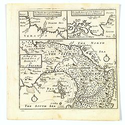
A Map of the Isthmus of Darien, & Bay of Panama.
A map of the Isthmus of Darien and Bay of Panama, with the twin insets of the North Sea Coast & the South Sea Coasts at the top. From A New Voyage around the World', ...
Date: London, ca 1700
Selling price: ????
Please login to see price!
Sold in 2019
PLANISPHAERIUM TERRESTRE CUM UTROQUE COELESTI HEMISHERIO, SIVE DIVERSA ORBIS TERRAQUEI.
A fine example of Adam Freidrich Zurner's scarce double hemisphere map of the World, embellished with 26 decorative scenes and scientific projections of the Celestial ski...
Date: Amsterdam, P.Schenk, 1700
Selling price: ????
Please login to see price!
Sold in 2019
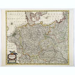
Nova Totius Germaniae Descriptio.
A highly detailed map of the Holy Roman Empire. It includes the modern day countries of Germany, Poland, Switzerland, Austria, The Netherlands, Belgium, the Czech Republi...
Date: Germany, ca 1700
Selling price: ????
Please login to see price!
Sold in 2020
FEZZAE et MAROCCHI Regna Africae Celeberrima.
A beautiful, old color map of Morocco, showing large fortified towns of Marakesh, Taradante and Fez, towns, mountains, rivers, lakes, etc. Tanger, Cueta and Rio Rabata al...
Date: Amsterdam, 1700
Selling price: ????
Please login to see price!
Sold in 2021
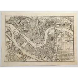
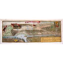
Lion, Ville Tres Considerable du Royaume.
A bird's-eye plan of Lion (Lyon) and vicinity that illustrates the strategic position of its fortifications on the Saône and the Rhône rivers. It provides an excellent ...
Date: Paris, 1700
Selling price: ????
Please login to see price!
Sold in 2023
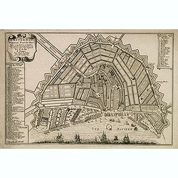
Amsterdam, fameux port de mer. . .
Fine town-plan of Amsterdam. Key at left identifies 83 important sites within the city. Key at upper right identifies the 26 "bastions" around the city walls, e...
Date: Paris, 1701
Selling price: ????
Please login to see price!
Sold in 2012
Tabula Totius Orbis Terrarum Exhibens Declinationes Magneticas, ad Annum 1700 composita ab Edmundo Halleyo simul cum Inclinationibus a Poundio observatis et Ventis Universalibus.
French reduced version of Edmond Halley (1656-1742) world map. California is shown as an island, Australia is only partially mapped, and New Zealand is not shown. The m...
Date: Paris, 1701
Selling price: ????
Please login to see price!
Sold in 2021
A System of Geography: or, a New & Accurate Description of the Earth in all its Empires, Kingdoms and States.
FIRST EDITION of Moll's important work with the title printed in red and black, 40 engraved maps, 2 full-page, small engraved map in text, 2 engraved solar diagrams. The...
Date: London, for A. and J. Churchill, 1701
Selling price: ????
Please login to see price!
Sold in 2014
Schlos Bangberg.
Lovely, large copper engraved aerial view of Closter Barnvach and Schlos Bangberg. Features a ribbon title cartouche, a heraldy coat of arms with a fox and a block cartou...
Date: Munich, 1701
Selling price: ????
Please login to see price!
Sold in 2017
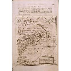
The ENGLISH EMPIRE in America.
Early English map of the British Colonies in North America from Herman Moll's 'A System of Geography' published in 1701. Compass Rose and rhumb lines with text on the rev...
Date: London, 1701
Selling price: ????
Please login to see price!
Sold in 2015