Browse Listings
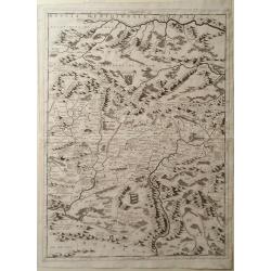
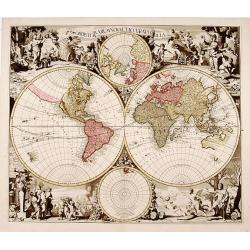
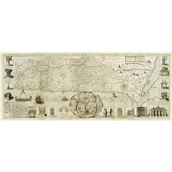
Map of Romania, Including Transylvania
Map of Romania including Transylvania by Vincenzo Coronelli. Overall a wonderfully detailed composition which features the location of Major Mountain ranges rivers and ma...
Date: Venice, 1698
Selling price: ????
Please login to see price!
Sold in 2010
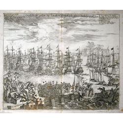
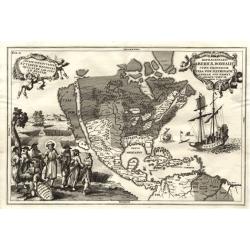
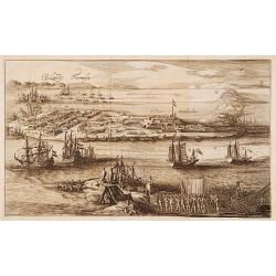
S. K. H. gehet zu Schiff in Engelland über Zufahren
Unusual print showing the departure of Wilhelm III of Oranien with his fleet, leaving to conquer England in November 1688. Very detailed view showing many ships in great...
Date: Frankfurt, 1698
Selling price: ????
Please login to see price!
Sold in 2011
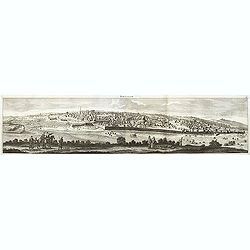
Ierusalem.
Panoramic view of Jerusalem as viewed from Mount of Olives with several figures in the foreground. Cornelis de Bruyn (1652-1726) was a painter who traveled through the Ho...
Date: Delft, Henrik van Krooneveld, 1698
Selling price: ????
Please login to see price!
Sold in 2011
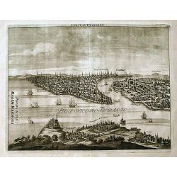
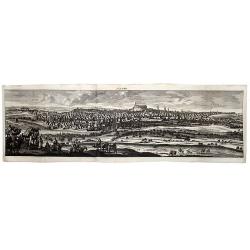
Constantinopolen.
A detailed view of the Bosphorus and Istanbul from "Reizen van Cornelis de Bruyn...". With numerous buildings and sailing ships. Some important points are named...
Date: Amsterdam, 1698
Selling price: ????
Please login to see price!
Sold in 2019
ALEPPO (Syria).
A striking view of the City of Aleppo, from Cornelis De Bruyn's 'Reizen'. De Bruyn (1652- ca 1726 ) was a Dutch portrait painter and traveler, and is remembered chiefly f...
Date: Delft, 1698
Selling price: ????
Please login to see price!
Sold in 2020
![Scotia parte settentrionale. . . [together with] Scotia parte meridionale . . .](/uploads/cache/45627-250x250.jpg)
Scotia parte settentrionale. . . [together with] Scotia parte meridionale . . .
A large two-sheet map of Scotland. The Northern map features a list of provinces and their capitals at the upper left and a title cartouche on the right side. The Souther...
Date: Venice, 1698
Selling price: ????
Please login to see price!
Sold in 2020
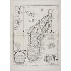
Isola di Madagascar, ò di S. Lorenzo scoperta dà Portoghesi nell'Anno 1506. . .
A striking, early map of the island of Madagascar, also showing part of the Mozambique coastline, the Comoros Islands and Reunion. The remarkable Vincenzo Coronelli (1650...
Date: Venice, 1698
Selling price: ????
Please login to see price!
Sold in 2021
Title page for: Le Nouveau & Illuminant Flambeau de la Mer.
Title page of the French edition of Johannes van Keulen's 'Nieuwe Groote Lichtende Zee-Fackel', published as ‘Le Nouveau & Illuminant Flambeau de la Mer’, 1698. ...
Date: Amsterdam, 1698
Selling price: ????
Please login to see price!
Sold in 2020
![Ragioni di Copernico. . . [9 charts on one sheet]](/uploads/cache/85319-250x250.jpg)
Ragioni di Copernico. . . [9 charts on one sheet]
The nine diagrams illustrate the various concepts that were debated in the 17th century. Each one with a title banner. Published in "Atlante Veneto".
Date: Venice, 1698
Selling price: ????
Please login to see price!
Sold in 2021

Alexius Hubertus Iaillot, Regis christianissimi geographus ordinarius, 1698.
Portrait of Alexis-Hubert Jaillot, half-length directed to left, looking to front, his left arm resting on a pedestal, wearing periwig, jacket and cloak, holding compass ...
Date: Paris, 1698
Selling price: ????
Please login to see price!
Sold in 2023
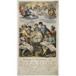
![[Title page] Imprimé a Amsterdam par Jean Van Ceulen . . .](/uploads/cache/47948-250x250.jpg)
[Title page] Imprimé a Amsterdam par Jean Van Ceulen . . .
Stunning copper engraving. Below the engraving is the advertisement in French for Joannes van Keulen giving his profession and address.Rare.Read more about decorative atl...
Date: Amsterdam, 1698
Selling price: ????
Please login to see price!
Sold in 2022
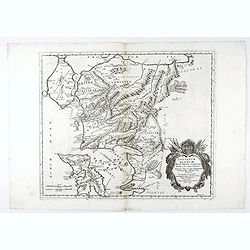
Troianum regnum, novem dinasteias complectens, Priami dum regna Manebant . . .
A fine historical map of part of northwest Anatolia in what is now Turkey, south of the southwest end of the Dardanelles / Hellespont and northwest of Mount Ida with the ...
Date: Paris, 1699
Selling price: ????
Please login to see price!
Sold in 2021
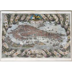
Venetien.
A rare unrecorded variant of Coronelli's spectacular bird's eye view of Venice. Hand colored, very possibly old coloring. A spectacular view of Venice, with a highly deco...
Date: Paris, ca. 1699
Selling price: ????
Please login to see price!
Sold in 2020
![Repraesentatio geographica itineris maritimi navis victoriae in qua ex personis CCXXVII finita navagatione rediere tantum XVII quae solo indusio tectae. . . [Magellan's circumnavigation]](/uploads/cache/85223-250x250.jpg)
Repraesentatio geographica itineris maritimi navis victoriae in qua ex personis CCXXVII finita navagatione rediere tantum XVII quae solo indusio tectae. . . [Magellan's circumnavigation]
This map shows the first World circumnavigation, journey of the ship Victoria of Ferdinand Magellan’s expedition, from and to Sevilla, thus the first ship ever to circu...
Date: Munich, 1699
Selling price: ????
Please login to see price!
Sold in 2021
Tabulae geographicae, quibus universa geographia vetus continetur
Fine historical atlas with 4 maps of the continents and 75 maps of the ancient world after Guillaume Sanson (1633-1703), Nicholas Sanson (1600-1667), Abraham Ortelius (15...
Date: Padua: Ex Typographia Seminarii, 1699
Selling price: ????
Please login to see price!
Sold in 2024
Troianum regnum, novem dinasteias complectens, Priami dum regna Manebant . . .
A fine historical map of part of northwest Anatolia in what is now Turkey, south of the southwest end of the Dardanelles / Hellespont and northwest of Mount Ida with the ...
Date: Paris, 1699
Selling price: ????
Please login to see price!
Sold in 2013
Globe gore with West Europe and Morocco.
Half-gore from his 110 centimeters in diameter globe of 1688 with part of West Europe, including England, Iceland, Netherlands, Belgium, France, Spain and Portugal. Moroc...
Date: Venice, 1696/1699
Selling price: ????
Please login to see price!
Sold in 2015
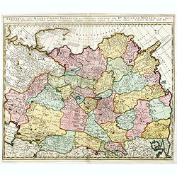
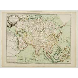
Tartaria, sive magni chami imperium ex credendis. . .
This map is particularly significant for its depiction of Russia, Siberia, and parts of Chinese Tartary, taken from the great six-sheet map by Nicolas Witsen, 1687. The i...
Date: Amsterdam, 1699
Selling price: ????
Please login to see price!
Sold in 2016
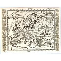
L'Europe Selon les Auth les Plus Modernes.
A rare map of Europe by Matthieu Ogier, published in Lyon in 1699. The map spans from Portugal to the eastern edge of the Mediterranean Sea and from Northern Africa to Gr...
Date: Lyon, 1699
Selling price: ????
Please login to see price!
Sold in 2016
Description de tout l'univers, en plusieurs Cartes, et en divers Traittez de Géographie et d'Histoire...
Very rare edition of this popular atlas by Nicolas Sanson, published by Arnout van Ravestein, in Amsterdam, in 1699.Pastoureau only mentions a Dutch version of Sanson's a...
Date: Amsterdam, Van Ravestein, 1699
Selling price: ????
Please login to see price!
Sold in 2018
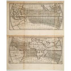
A view of the General & Coasting Trade-Winds in the Atlantic
The world in two parts each focussing on the trade wind belt between 35degrees North and 35degrees South latitude. Engraved by Herman Moll. Based on Halley's 1686 wind ma...
Date: London 1699
Selling price: ????
Please login to see price!
Sold
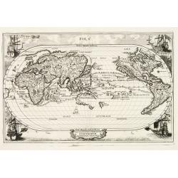
Atlantis Insula.
Third state (of five) of the unusual map that purports to show the earth about 200,000 years ago before its settlement by humans. The god Neptune had divided up the land ...
Date: Paris 1699
Selling price: ????
Please login to see price!
Sold
Troianum Regnum.
A fine historical map of part of northwest Anatolia in what is now Turkey, south of the southwest end of the Dardanelles / Hellespont and northwest of Mount Ida with the ...
Date: Paris 1699
Selling price: ????
Please login to see price!
Sold in 2010
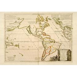
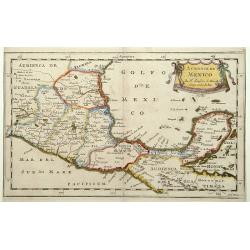
Repraesentatio Americae Borealis...
An interesting religious map of North America, showing the Catholic regions illuminated and the Protestant and still uncolonized lands swathed in darkness. California is ...
Date: Munich 1699
Selling price: ????
Please login to see price!
Sold
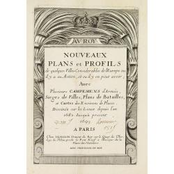
Title page : NOUVEAUX PLANS et PROFILS de quelques villes considérables de l'Europe..
Uncommon title page, the date adjusted in manuscript.
Date: Paris, 1699
Selling price: ????
Please login to see price!
Sold
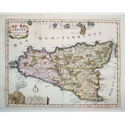
La Sicile Divisee en ses trois Valles
A fabulous small map of Sicily showing the island's political divisions, with considerable detail of topography, cities, towns and villages. The work also includes the Ae...
Date: Paris, 1699
Selling price: ????
Please login to see price!
Sold
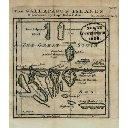
The GALLAPAGOS ISLANDS Discovered by Capt. John Eaton
Important map of the Galapagos Islands in the Pacific Ocean, now belonging to Ecuador. Discovered first by Spanish sailors, then a hideaway for Pirates, they later came u...
Date: London, 1699
Selling price: ????
Please login to see price!
Sold in 2008
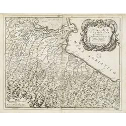
Legatione della Romagna . . .
A uncommon, late 17th century map of part of the Romagna region, based on the reports of Giacomo Cantelli da Vignola and published in Rome, by Domenico de Rossi's in his ...
Date: Rome, ca. 1699
Selling price: ????
Please login to see price!
Sold in 2009
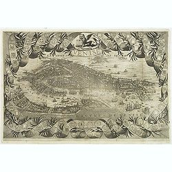
Venise.
A rare and decorative bird's eye view of Venice, copied after Coronelli's plan of 1693. Included in "Voyages De Mr. Du Mont En France, En Italie, En Allemagne, à Ma...
Date: Paris, Etienne & François Foulque, c.1699
Selling price: ????
Please login to see price!
Sold in 2011
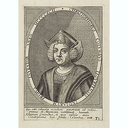
Christophorus Columbus Liguriensis Indiarum Primus Inventor Anno MCCCCXCII.
Portrait of Christopher Columbus (c. 31 October 1451 – 20 May 1506), explorer, colonizer, and navigator, born in the Republic of Genoa, in north-western Italy. Under th...
Date: Antwerp, c.1700
Selling price: ????
Please login to see price!
Sold in 2023
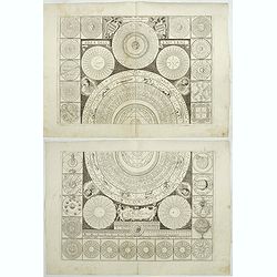
Idea dell'Universo.
A set of diagrams relating to astronomy and astrology, with wind head borders. The subjects include a perpetual calendar, the zodiac, the parts of the body dominated by e...
Date: Venice, c. 1700
Selling price: ????
Please login to see price!
Sold in 2019
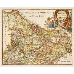
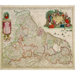
Hodiernae Belgicae sive Germaniae..
Decorative miniature map of the Low Countries. West to the top.
Date: Amsterdam 1700
Selling price: ????
Please login to see price!
Sold
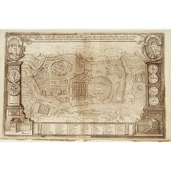
Eigentlicher Situs und Grundt Riss.. Statt Jerusalem..
Uncommon bird's-eye view of ancient Jerusalem. In top left a portrait of King David and upper right a portrait of Salomon. With a numbered key of 52 most important buildi...
Date: Germany 1700
Selling price: ????
Please login to see price!
Sold
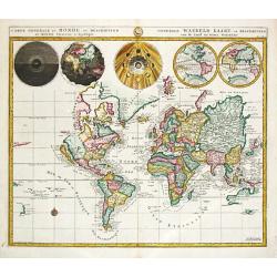
Orbis terrarum nova et accurata..
Exquisitely decorated double hemisphere world map. The map has been updated geographically compared to Valck's earlier ones. The map's outer decoration is the same as tha...
Date: Amsterdam 1700
Selling price: ????
Please login to see price!
Sold
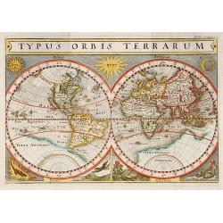
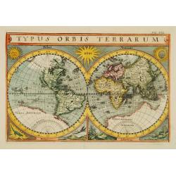
Typus orbis terrarum.
World map in double hemisphere showing California as an island.With in top the sun and the moon, in the lower part a representation of Fire, Air, Earth and Water. With a ...
Date: c.1700
Selling price: ????
Please login to see price!
Sold
Frisiae Libera.
Unusual map of ancient Holland Germany and Belgium. The "Zuthera Zea" is still enclosed and a great portion of the country is covered with swamps and forests.Se...
Date: Amsterdam 1700
Selling price: ????
Please login to see price!
Sold
Regni Poloniae et Ducatus Lithuaniae Voliniae..
Rare issue of Justus Danckerts attractive map of Poland and Lithuania.Decorative title cartouche upper left hand corner.SEE a large description of the Danckerts family on...
Date: Amsterdam 1700
Selling price: ????
Please login to see price!
Sold

Leaf from a very large antiphoner, written in Latin on heavy vellum.
RECTO: The leaf is numbered 33. and is the hair side of the vellum.Large miniature, 140 x 140mm of St. Luce in white and red robes, on a yellow background and a large cap...
Date: Spain c.1700
Selling price: ????
Please login to see price!
Sold
Audience de Mexico.
From a pocket atlas called: Description de tout l'Univers, published by F.Halma. Engraved by A. de Winter."
Date: Amsterdam, 1700
Selling price: ????
Please login to see price!
Sold
A new map of.. Plantations of the English in America..
"A boldly engraved large-scale map of the Carolinas, Nova Scotia, Bermuda, Barbados and Jamaica appear as large insets on this interesting uncommon and attractive ma...
Date: London 1700
Selling price: ????
Please login to see price!
Sold
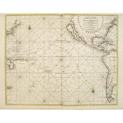
Mer de Sud ou Pacifique contenant l'Isle de Californe. . .
Intriguing map of the Pacific copied from important manuscript maps collected by the Portuguese crown and secreted away in Portuguese archives. Showing California with in...
Date: Amsterdam, 1700
Selling price: ????
Please login to see price!
Sold in 2016
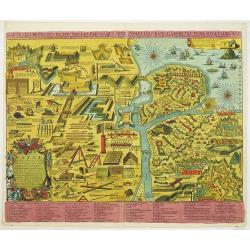
Tafel in welke vertoont werden alle werk-tuigen behorende tot de krygs-kunde, Vestingbouw en Artillery e. als mede. . .
An attractive instructional plate showing a collage of various systems of fortifications, both inland and coastal, and the weapons and techniques used to attack and defen...
Date: Amsterdam, 1700
Selling price: ????
Please login to see price!
Sold in 2013
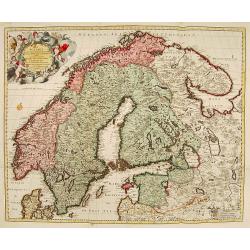
La Scandie.. Suede, Danemarc & Norvegue.
Fine map including Sweden, Norway, Denmark and Finland. Decorative title cartouche with dedication to Charles XII. Prepared by Nicolaas Visscher, a uncommon re-issue by P...
Date: Amsterdam 1700
Selling price: ????
Please login to see price!
Sold
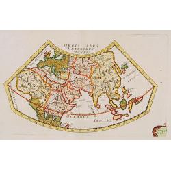
Orbis Pars Veteribus Cognita.
A very nice map showing ancient world.
Date: Paris, ca. 1700
Selling price: ????
Please login to see price!
Sold
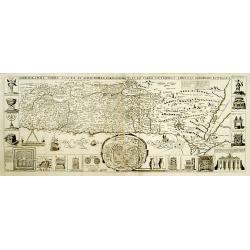
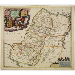
Chorographia Terrae Sanctae in Angustiorem..
Rare. Large visually rich map decorated with illustrations of the sacred objects and places of Judaism. In the bottom center is a plan of ancient Jerusalem, and the route...
Date: Amsterdam ca. 1700
Selling price: ????
Please login to see price!
Sold
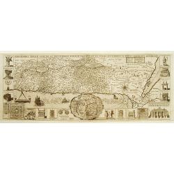
Chorographia Terrae Sanctae in Angustiorem..
Rare. Large visually rich map decorated with illustrations of the sacred objects and places of Judaism. In the bottom center is a plan of ancient Jerusalem, and the route...
Date: Amsterdam ca. 1700
Selling price: ????
Please login to see price!
Sold
T'Eylandt Formosa.
Scarce panoramic view of "Fort Zeelandia" on the island of Formosa.
Date: Amsterdam 1700
Selling price: ????
Please login to see price!
Sold
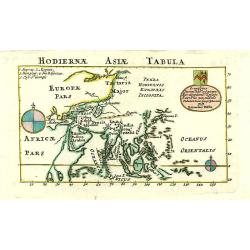
Hodiernae Asiae Tabula.
A boldly engraved map of the East Indies with large compass card and cartouche with a dedication to John Trelawney. The area north of Korea till Nova Zembla left blank an...
Date: London 1700
Selling price: ????
Please login to see price!
Sold
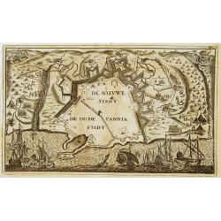
De Nieuwe Stadt / De Oude Stadt Candia.
Rare plan of the town of Candia. With extensive shipping on foreground and Turkish troops sieging the town.The Siege of Candia (Heraklion, Crete) (1648-1669) was possibly...
Date: Netherlands c.1700
Selling price: ????
Please login to see price!
Sold
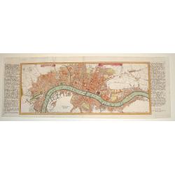
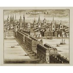
LONDEN WESTMUNSTER U SOUDWARK
A very finely engraved view of London as seen at the start of the 18th century. The work's title is presented in two ribbons at the top portion of the engraving. Two comp...
Date: Germany, c. 1700
Selling price: ????
Please login to see price!
Sold
Chorographia Terrae Sanctae in Augustiorem..
Rare. Large visually rich map decorated with illustrations of the sacred objects and places of Judaism. In the bottom center is a plan of ancient Jerusalem, and the route...
Date: Amsterdam, ca.1700
Selling price: ????
Please login to see price!
Sold
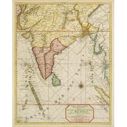
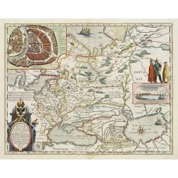
Carte particuliere d'une Partie d'Asie.. Ceylon, Maldives..
Intriguing map of India, Ceylon, Maldives and East Coast of Sumatra, and Malaysia. From Suite du Neptune François, ou Atlas Nouveau des Cartes Marines.From the rare and ...
Date: Amsterdam 1700
Selling price: ????
Please login to see price!
Sold
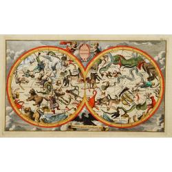
Globe celeste Coeli en arrant Gloriam dei.
Double hemispherial celestial showing signs of the zodiac.
Date: Paris 1700
Selling price: ????
Please login to see price!
Sold
Typus Orbis Terrarum.
Uncommon double hemisphere world map, showing California as an island. In corners sun, moon and representations of four elements. With a large southern continent, but Aus...
Date: Germany c.1700
Selling price: ????
Please login to see price!
Sold
L'Asie..
Prepared by G. de L'Isle of c. 1700 and published by Louis Renard of Amsterdam.Rare Amsterdam issue.The blank areas between the 'peninsula' of Nouvelle Zemla and the east...
Date: Amsterdam, 1700
Selling price: ????
Please login to see price!
Sold
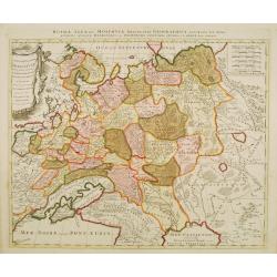
La Russie Blanche ou Muscovie
European Russia, including Ukraine.
Date: Amsterdam 1700
Selling price: ????
Please login to see price!
Sold
Die Brücke zu London.
Decorative view of London bridge.
Date: Nuremberg 1700
Selling price: ????
Please login to see price!
Sold
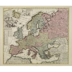
Europae in Tabula Geographica Delineatio. . .
Uncommon map of Europe with fine title cartouche and key to longitude and latitude of the most import cities.
Date: Amsterdam, 1700
Selling price: ????
Please login to see price!
Sold in 2013
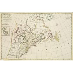
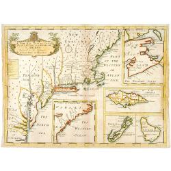
Carte Nouvelle de L'Amerique Angloise Contenant La Virginie, Mary-Land, Caroline, Pensylvania, Nouvelle Jorck, N. Jarsey, N. France..
A unique map of eastern North America with oversized Great Lakes. Pennsylvania includes both Delaware and eastern Maryland and almost bisects New York. Virginia includes ...
Date: Amsterdam c. 1700
Selling price: ????
Please login to see price!
Sold
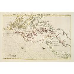
Carte Particuliere de Virginie, Maryland, Pennsilvanie, La Nouvelle Jarsey. Orient et Occidentale.
Large scale, decorative map centered on Maryland and the Chesapeake Bay. Shown is an area from Staten Island in New York southward to Carratuck Inlet in North Carolina wi...
Date: Amsterdam c. 1700
Selling price: ????
Please login to see price!
Sold
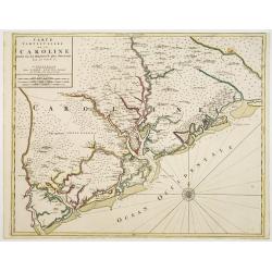
Carte Particuliere de la Caroline Dresse Sur les Memoires le plus Nouveaux.
Large, decorative map of today South Carolina centered on Charleston. The area represented extends from the South Edisto River northward to the Santee River. Illustrated ...
Date: Amsterdam 1700
Selling price: ????
Please login to see price!
Sold
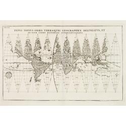
Typus Totius Orbis Terraquei Geographice..
Finely engraved set of 12 globe gores. Fascinating Northwest Passage treatment. Excellent detail in Australia and a nice bit of New Zealand shown, along with a curious ov...
Date: Munich 1700
Selling price: ????
Please login to see price!
Sold
Navigationes Praecipuae Europaeorum ad Exteras Nationes.
Splendid map of the world on an oval projection showing California as an Island and partially mapped Australia and New Zealand.This map is from the series produced by Sch...
Date: Munich 1700
Selling price: ????
Please login to see price!
Sold
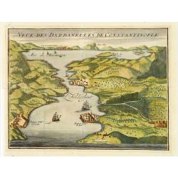
Veue des Dardanelles de Constantinople.
Attractive birds eye view of Hellespont, fortifications and the city of Istanbul in the background.
Date: Paris c.1700
Selling price: ????
Please login to see price!
Sold
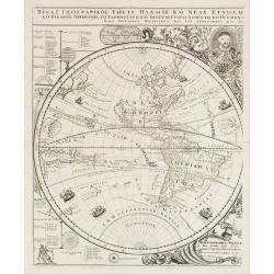
Title in Greek (Sub-title: Index Geographicus tum vete..)
This sheet covers the western hemisphere, with California as an island, and has Greek lettering throughout. As stated in the long Greek title and Latin sub-title it is th...
Date: Padua, 1700
Selling price: ????
Please login to see price!
Sold in 2010
Geographiae Sacrae Tabula, in qua Terra Promissa..
Attractive map after N.Sanson\'s folio map of 1662 with decorative cartouche showing the map of Canaan presented to Joshua by his spies. Engraved by A.Winter.First added ...
Date: Halma, Amsterdam, after 1700
Selling price: ????
Please login to see price!
Sold in 2009
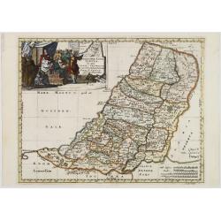
Iudea sive Terra Sancta quae Israelitarum..
Rare issue of T. Danckerts attractive map of part of Israel.Decorative title cartouche upper left hand corner.
Date: Amsterdam 1700
Selling price: ????
Please login to see price!
Sold
Carte Generale Du Monde.
Pieter Mortier (1661-1711), Amsterdam bookseller and printer of French descent published a.o.the atlas and the sea-atlas of Sanson-Jaillot and of de l\' Isle. The firm co...
Date: Amsterdam, 1700
Selling price: ????
Please login to see price!
Sold in 2009
De Zwarte Zee, eertyts Pontus Euxinus.
Nicolas Sanson (1600-67), ' father of the French cartography' and founder of the Sanson firm. Atlas ' Cartes générales de toutes les parties du Monde', 1658-70 and a po...
Date: Amsterdam, 1700
Selling price: ????
Please login to see price!
Sold
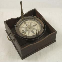
Important early azimuth compass.
The gimballed and weighted brass compass bowl has a removable glazed cover, mounted with folding brass sight vanes, four unusually turned brass capstan posts to support d...
Date: Dutch, c 1700
Selling price: ????
Please login to see price!
Sold
Novissima et accuratissima XVII Provinciarum tabula A. J.Bormeester.
Rare issue of Justus Danckert's attractive map of the Low Countries.Decorative title cartouche upper right hand corner.
Date: Amsterdam 1700
Selling price: ????
Please login to see price!
Sold
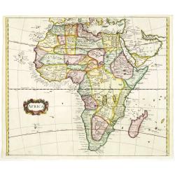
AFRICA
Nice map of Africa giving a wealth of information. Some names are translated in to English.
Date: London, c. 1700
Selling price: ????
Please login to see price!
Sold in 2011
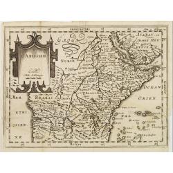
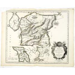
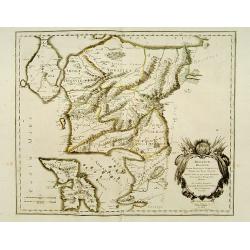
L'Abissinie.
Uncommon and delightful map of Equatorial Africa, extending from the Atlantic shores as far as the Horn of Africa.It is focused on the White Nile stream which bears the n...
Date: Amsterdam 1700
Selling price: ????
Please login to see price!
Sold
Peru ou Perou.
Charming map of Peru. Including some of the territory of today Equador on the north and extending southwards as far as the Atacama desert in Chile. Decorated with a large...
Date: Amsterdam 1700
Selling price: ????
Please login to see price!
Sold
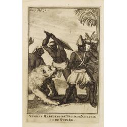
Negres. Habitans de Nubie de Nigritie et de Guinée.
Decorative engraving representing people of Central Africa.
Date: Amsterdam, 1700
Selling price: ????
Please login to see price!
Sold in 2008
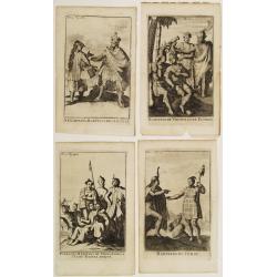
Four engravings by M. Duplessis.
4 decorative engravings representing native American people.Mexiquains. Habitans des Antiles.Habitans de Virginie et de Floride.Habitans du Perou.Patagons. Habitans du Ch...
Date: Amsterdam 1700
Selling price: ????
Please login to see price!
Sold
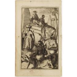
![[Title page] Table Des Cartes etc: Du Sr. Sanson..](/uploads/cache/22714-250x250.jpg)
[Title page] Table Des Cartes etc: Du Sr. Sanson..
Large, powerfully engraved title page. Geographic scholars at work in a library are depicted along the bottom.More about title page [+]
Date: Amsterdam, 1700
Selling price: ????
Please login to see price!
Sold in 2021
![[No title] [wall map of Southern India, Ceylon and part of Malaysia]](/uploads/cache/22782-250x250.jpg)
[No title] [wall map of Southern India, Ceylon and part of Malaysia]
An attractive large wall map of Southern India, Ceylon and part of Malaysia. Originally in 2 sheets, this is the bottom sheet.With 3 inset plans showing the surroundings ...
Date: Paris, c. 1700
Selling price: ????
Please login to see price!
Sold
Title page: Geographie Universelle Tom. III.
Decorative title page illustrating exotic people, animals, trees and monuments from various parts of the world.
Date: Amsterdam 1700
Selling price: ????
Please login to see price!
Sold
Perigrinatie ofte Veertich-jarige Reyse der Kinderen Israels.
Dutch so-called ' Staten' bibles, published between 1637 and c. 1760, contained 5 maps: The World, ' Paradise', The Perigrinations, The Promised Land Canaan, The Travels ...
Date: Amsterdam / Dordrecht, Pieter Keur, Pieter Rotterdam 1700
Selling price: ????
Please login to see price!
Sold in 2008