Browse Listings
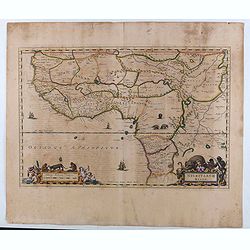
![[Hornius Map of the Holy Land, Israel, and Palestine]](/uploads/cache/44765-250x250.jpg)
[Hornius Map of the Holy Land, Israel, and Palestine]
A fine example of a single sheet from the original six sheet map by Georgius Hornius map of the Holy Land. The map is embellished with countless vignettes and other image...
Date: Amsterdam, Janssonius, 1662
Selling price: ????
Please login to see price!
Sold in 2020
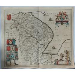
Lincolnia Comitatus. Anglia Lincoln-Shire.
A fine old color example of Blaeu's map of Lincoln, from his “Atlas Maior”, one of the most sought-after atlases by collectors and institutions today due to the atten...
Date: Amsterdam, 1662
Selling price: ????
Please login to see price!
Sold in 2019
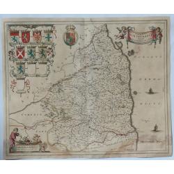
Comitatus Northumbria Vernacule Northumberland.
A fine very decorative old color map of Northumberland from the 1662 publication of Blaeu's “Atlas Major", one of the most sought-after atlases by collectors and i...
Date: Amsterdam, 1662
Selling price: ????
Please login to see price!
Sold in 2019
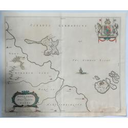
Insula Sacra vulgo Hosy Iland et Farne.
Map of Holy Island and Farne off the coast of Northumberland, in north east England, from the 1662 publication of Blaeu's “Atlas Major" one of the most sought-afte...
Date: Amsterdam, 1662
Selling price: ????
Please login to see price!
Sold in 2019
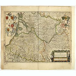
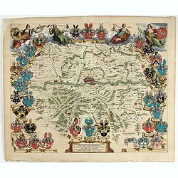
Gouvernement de la Guienne & Gascogne.
Decorative map of Guyenne et Gascogne with cartouches on each side with regional coats of arms and an allegorical title cartouche with wine grapes and puttie.
Date: Amsterdam, ca. 1662
Selling price: ????
Please login to see price!
Sold in 2019
Nigritarum regio.
Blaeu's map of a part of West Africa, from Tropic of Cancer southward including the Senegal River to Angola. The map includes decorative title and scale statement cartouc...
Date: Amsterdam, 1662
Selling price: ????
Please login to see price!
Sold in 2020
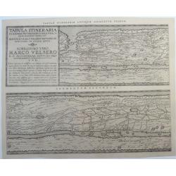
Tabula Itineraria Ex Illustri Peutingerorum. (the two Western-European segments only, Segmentum Primum, and Segmentum Secundum.)
A rare and famous map from the Peutinger Table comprising Western-Europe. Twee parts of eight only. The ancient roadmap depicts the imperial roads and posts within the Ro...
Date: Amsterdam, ca. 1662
Selling price: ????
Please login to see price!
Sold in 2020
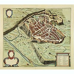
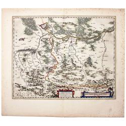
Nordertheil des Amptes Gottorff, Anno 1649.
Map after J. Mejer from Danckwerth, shows the area around Hollingstedt, Holm, Schleswig, Eckernförde, Kappeln, Schlei, Husby. Appeared first in 1652 in "New descrip...
Date: Amsterdam, 1662
Selling price: ????
Please login to see price!
Sold in 2022
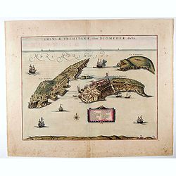
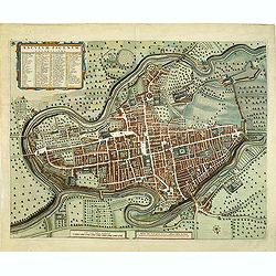
Insulae Tremitanae, olim Diomedeae dictae.
In his Atlas Maior of 1662, Joan Blaeu (1598-1673) published 58 maps of Italian regions. Most of these maps were unedited reprints of maps that Blaeu had originally publi...
Date: Amsterdam, 1662
Selling price: ????
Please login to see price!
Sold in 2020
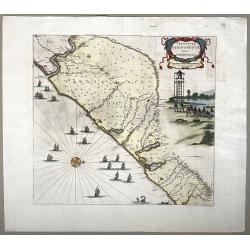
Praefecturae Paranambucae Pars Meridionalis
Original map of the coast of Pernambuco, Brazil, from the Rio de S. Francisco to Paripueira.Title in a cartouche at top right, below is a nice scene with fishermen pullin...
Date: Amsterdam, 1662
Selling price: ????
Please login to see price!
Sold in 2022
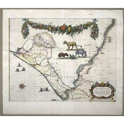
Praefectura de Ciriji.
Full title: 'Praefecture de Ciriji vel Seregippe Del Rey cium Itapuama'. Showing a large part of the river de S. Francisco and further south to Aracaju, province of Sergi...
Date: Amsterdam, 1662
Selling price: ????
Please login to see price!
Sold in 2022
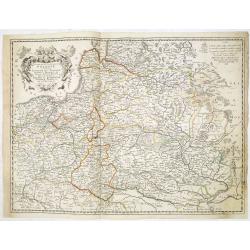
Nova XVII Provinciarum Inferioris Germaniae Descriptio.
An early and rare map by de Wit of the 17 provinces. The map was originally engraved by P. Kaerius in 1607, and later came into the possession of de Wit, who re-engraved ...
Date: Amsterdam 1662
Selling price: ????
Please login to see price!
Sold in 2022
![[Battle of Szigetvár] Portraict de l'Armée de l'Empereur Turc Rangée en Bataille](/uploads/cache/49040-250x250.jpg)
[Battle of Szigetvár] Portraict de l'Armée de l'Empereur Turc Rangée en Bataille
An early wood block printed bird's-eye view showing the Battle of Szigetvár (Hungary). Below the wood block print is a 8-lines description in French. The battle was one ...
Date: Paris, 1662
Selling price: ????
Please login to see price!
Sold in 2025
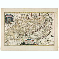
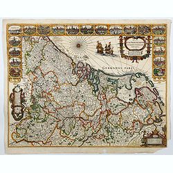
Novam Hanc TERRITORII FRANCOFURTENSIS Tabulam.
One of the most decorative maps of Hessen, centered on Frankfurt and the river Main, bordered by design with arms and titles of 33 dignitaries, allegorical figures and ca...
Date: Amsterdam, 1663
Selling price: ????
Please login to see price!
Sold in 2022
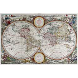
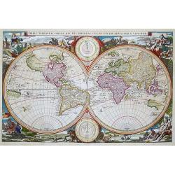
Orbis Terrarum Tabula. . .
Magnificent double hemisphere Dutch Bible map. Surrounded by engravings of animals and four female allegorical representations of the continents. South America of 7inch, ...
Date: Amsterdam, 1663
Selling price: ????
Please login to see price!
Sold in 2023
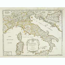
Carte de L'Italie et des Isles adjacentes. . .
Detailed map of Italy, Sardine and Malta. With inset map of Sicily. Title at bottom with erasure in the title. Map is dated 1663 and was engraved by L'Huilier.
Date: Paris, 1663
Selling price: ????
Please login to see price!
Sold
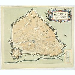
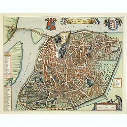
Ichnografia del Recinto del la citta di Ferrara. . .
A beautifully engraved and richly decorated plan of Ferrera. With a key (1-18) in lower right corner referring to the principal places of interest in the town. From "...
Date: Amsterdam, 1663
Selling price: ????
Please login to see price!
Sold in 2013
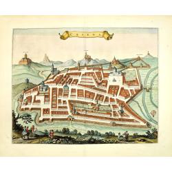
Cesena.
A beautifully engraved and richly decorated town-plan of Cesena, a city in the Emilia-Romagna region of northern Italy, south of Ravenna and west of Rimini. From "Ci...
Date: Amsterdam, 1663
Selling price: ????
Please login to see price!
Sold in 2012
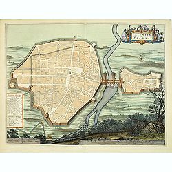
Faventia, vulgo Faensa.
A beautifully engraved and richly decorated plan of Faenza, an important historic city situated on the Via Emilia between Rimini and Bologna.From "Civitates Ecclesia...
Date: Amsterdam, 1663
Selling price: ????
Please login to see price!
Sold in 2012
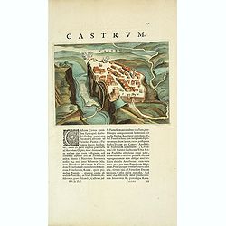
Castrum.
A beautifully engraved and richly decorated town-plan of a town and castle along a river. . With a key (1-18) in lower right corner referring to the principal places of i...
Date: Amsterdam, 1663
Selling price: ????
Please login to see price!
Sold in 2012
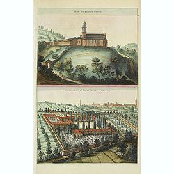
San. Michele in Bosco. / Convento de' Padri della Certosa.
A beautifully engraved and richly decorated town-plan of San Michele in Bosco and in bottom Ordine Certosino. From "Civitates Ecclesiastici - Theatrum Civitatum et a...
Date: Amsterdam, 1663
Selling price: ????
Please login to see price!
Sold in 2012
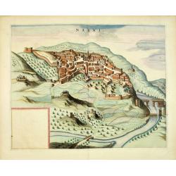
Narni.
A beautifully engraved and richly decorated of Narni, an ancient hilltown and comune of Umbria, in central Italy. From "Civitates Ecclesiastici - Theatrum Civitatum...
Date: Amsterdam, 1663
Selling price: ????
Please login to see price!
Sold in 2013
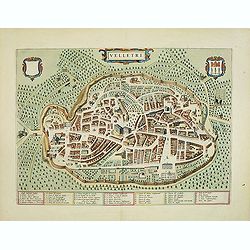
Velletri.
A beautifully engraved and richly decorated town-plan of Velletri, a comune in the province of Rome, on the Alban Hills, in Lazio (Latium). With a key (1-40) in bottom. F...
Date: Amsterdam, 1663
Selling price: ????
Please login to see price!
Sold in 2012
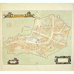
Urbino.
A schematic town-plan of Urbino. From "Civitates Ecclesiastici - Theatrum Civitatum et admirandorum Italiae".Joan Blaeu originally wanted to put two five-volume...
Date: Amsterdam, 1663
Selling price: ????
Please login to see price!
Sold in 2012
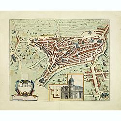
Macerata.
A beautifully engraved and richly decorated town-plan of Macerata, the provincial capital of Macerata in Le Marche region. The medieval part is located on a hill overlook...
Date: Amsterdam, 1663
Selling price: ????
Please login to see price!
Sold in 2012
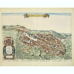
Auximum vulgo Osimo.
A beautifully engraved and richly decorated town-plan of Osimo. A key (1-31) at the bottom refers to the principal places of interest in the town. From "Civitates Ec...
Date: Amsterdam, 1663
Selling price: ????
Please login to see price!
Sold in 2012
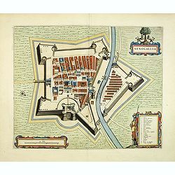
Senogallia.
A beautifully engraved and richly decorated town-plan of Senigallia. With a key (A-Z) in lower right corner referring to the principal places of interest in the town. Fro...
Date: Amsterdam, 1663
Selling price: ????
Please login to see price!
Sold in 2013
Avenio Vulgo Avignon.
A beautifully engraved and richly decorated town-plan of Avignon. With a key (1-56) around the plan referring to the principal places of interest in the town. From "...
Date: Amsterdam, 1663
Selling price: ????
Please login to see price!
Sold in 2012
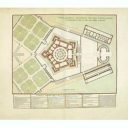
Ichnographia Generalis Palatii Farnesiorum Caprarola Dicti, XXI Ab Urbe Lapide. . .
A beautifully engraved and richly decorated plan of the garden and Villa Farnese, also known as Villa Caprarola, is a mansion in the town of Caprarola in the province of ...
Date: Amsterdam, 1663
Selling price: ????
Please login to see price!
Sold in 2012
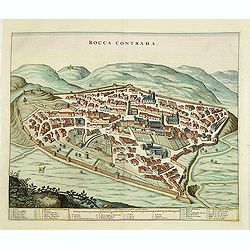
Rocca Contrada.
A beautifully engraved and richly decorated town-plan of Arcevia (Marche), formerly known as Rocca Contrada. With a key (1-33) in bottom referring to the principal places...
Date: Amsterdam, 1663
Selling price: ????
Please login to see price!
Sold in 2013
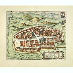
Civitas-Nova in Piceno. / Mezzogiorno.
A beautifully engraved and richly decorated town-plan of Civitanova Marche. With a key (1-24) in lower right corner referring to the principal places of interest in the t...
Date: Amsterdam, 1663
Selling price: ????
Please login to see price!
Sold in 2012
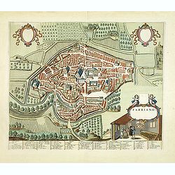
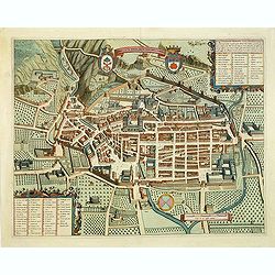
Fabriano.
A beautifully engraved and richly decorated town-plan of Fabriano, with in the center Piazza Maggiore with S.Francisco and the papal palace to the left. With a key (1-84)...
Date: Amsterdam, 1663
Selling price: ????
Please login to see price!
Sold in 2012
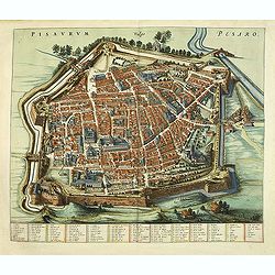
Pisaurum Vulgo Pesaro.
A beautifully engraved and richly decorated town-plan of Pesaro. With a key (1-100 / a- z) in bottom referring to the principal places of interest in the town. From "...
Date: Amsterdam, 1663
Selling price: ????
Please login to see price!
Sold in 2012
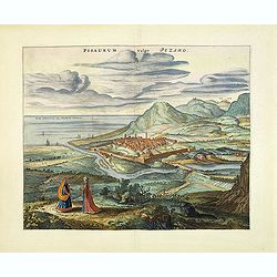
Pisaurum vulgo Pezaro.
A beautifully engraved and richly decorated town-plan of the seaside city of Pesaro and the surrounding countryside, as well as a dramatic depiction of the Adriatic coast...
Date: Amsterdam, 1663
Selling price: ????
Please login to see price!
Sold in 2012
Asculum Picenum.
A beautifully engraved and richly decorated town-plan of Ascoli Piceno. A key (1-18) in the lower right corner refers to the principal places of interest in the town. Fro...
Date: Amsterdam, 1663
Selling price: ????
Please login to see price!
Sold in 2012
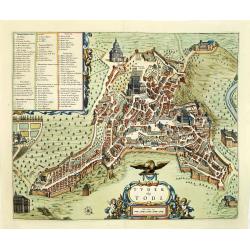
Tuder vulgo Todi.
A beautifully engraved and richly decorated town-plan of Todi. With a key (1-86) in upper left corner referring to the principal places of interest in the town. From &quo...
Date: Amsterdam, 1663
Selling price: ????
Please login to see price!
Sold in 2012
Gubbio Cita Regia Antichiss, Dell'umbria.
A beautifully engraved and richly decorated town-plan of Gubio. With a key (1-45) in lower right corner referring to the principal places of interest in the town. From &q...
Date: Amsterdam, 1663
Selling price: ????
Please login to see price!
Sold in 2012
Acquapendente.
A beautifully engraved and richly decorated town-plan of Acquapendente in the province of Viterbo, Lazio. A key (1-27) in the lower right corner refers to the principal p...
Date: Amsterdam, 1663
Selling price: ????
Please login to see price!
Sold in 2012
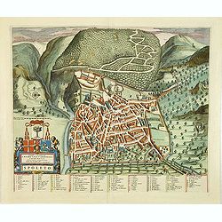
Spoleto.
A beautifully engraved and richly decorated town-plan of Spoleto. With a key (1-87) in lower right corner referring to the principal places of interest in the town. From ...
Date: Amsterdam, 1663
Selling price: ????
Please login to see price!
Sold in 2012
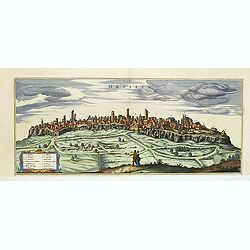
Orvieto.
A beautifully half-page engraved and richly decorated of Orvieto. With a key (1-13) in lower left corner referring to the principal places of interest in the town. From ...
Date: Amsterdam, 1663
Selling price: ????
Please login to see price!
Sold in 2013
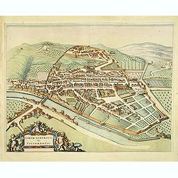
Forum Sempronii vulgo Fossombrone.
A beautifully engraved and richly decorated town-plan of Fossombrone. In the center the Church of Sant'Agostino still in its 14th century shape.From "Civitates Eccle...
Date: Amsterdam, 1663
Selling price: ????
Please login to see price!
Sold in 2013
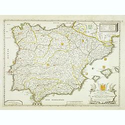
L'Espagne Divisée en ses Principaux Royaumes, dédiée a Haut et puissant Seigneur Messir Francois le Bouteiller . . .
Detailed map of Spain and Portugal, with fine title cartouche lower right.Dated 1663. A later edition with the date 1684 exists.More about [+]
Date: Paris, 1663
Selling price: ????
Please login to see price!
Sold in 2012
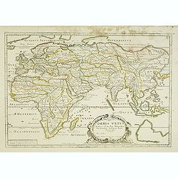
Orbis Vetus . . .
Uncommon map of the Ancient world showing the European and Asian continents with in the lower right corner a blank landmass with incomplete coastlines appears in the loca...
Date: Paris, 1663
Selling price: ????
Please login to see price!
Sold in 2023
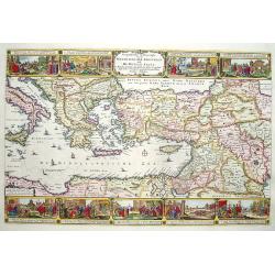
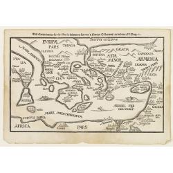
Geographische Beschryvinghe van de Wandeling der Apostelen ende De Reysen Pauli. . .
A decorative map of the eastern Mediterranean from Rome through Asia Minor and the Holy Land, depicting the route of Apostle Paul, including Italy, Sicily, Cyprus, Turkey...
Date: Amsterdam, 1663
Selling price: ????
Please login to see price!
Sold in 2012
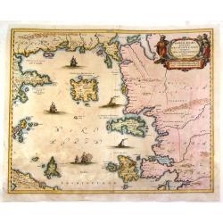
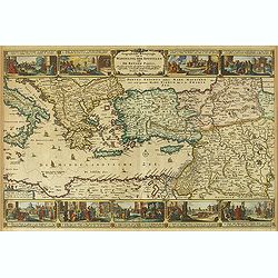
Maris Aegaei Quod hodie Archipelago Nuncupatur, Pars Septentrionalis.
Fine copperplate map featuring the Aeagean Islands of Greece. The map is decorated by a pleasant figural title cartouche and seven detailed ships in the seas. The cartogr...
Date: Amsterdam, 1663
Selling price: ????
Please login to see price!
Sold in 2015
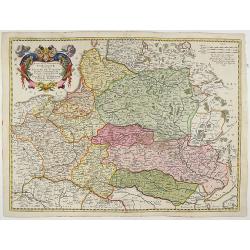
Etats de la couronne de Pologne ou sont les Royaume de Pologne, . . . De l'Ukanie &c.
A map of modern day Poland, Lithuania, Belarus and Ukraine. Dantzick (Gdansk) clearly marked on the coast and stretching down to the Black Sea. Numerous place-names of co...
Date: Paris, 1663
Selling price: ????
Please login to see price!
Sold in 2013
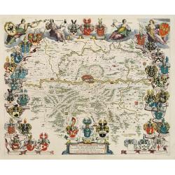
Ducatus Silesiae Grotganus cum Districtu Episcopali Nissensi Delineatore Iona Sculteto, Silesio.
Attractive old colored engraved map of the duchy Wohlau in Polen. In the upper left corner dedication with coat of arms to Georg Rudolf of Liegnitz (1595–1653).Publishe...
Date: Amsterdam, 1663
Selling price: ????
Please login to see price!
Sold in 2014
![[Map covering the area from India till Australia.]](/uploads/cache/36448-250x250.jpg)
[Map covering the area from India till Australia.]
Probably of Portuguese origin, this appeared in Thevenot's Relations de divers Voyages , the greatest collection of travel accounts of the seventeenth century. Of partic...
Date: Paris, Langlois, 1663
Selling price: ????
Please login to see price!
Sold in 2015
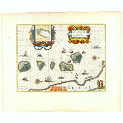
Moluccae Insulae Celeberrimae.
Showing the geographical features of the spice islands, and decorated with ships, sea monsters and a handsome cartouche. In addition to a sumptuous title cartouche, the m...
Date: Amsterdam, 1663
Selling price: ????
Please login to see price!
Sold in 2016
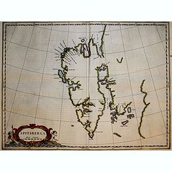
Spitsberga.
Blaeu's map of Spitsbergen was based on the Muscovy Company's map of 1625, but the north coast is completely new. It makes the heads of Wiche sound (Liefde bay) and Wyde ...
Date: Amsterdam, 1663
Selling price: ????
Please login to see price!
Sold in 2018
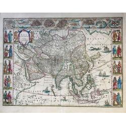
Asia noviter delineata.
An elegant map with columns of figures on either side depicting the native manners of dress, and nine city plans and views at the top.Japan is shown accurately unusually ...
Date: Amsterdam, 1663
Selling price: ????
Please login to see price!
Sold in 2016
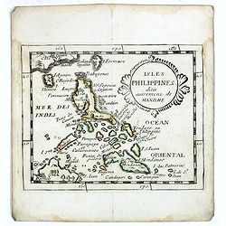
Isles Philippines dites autrement de Manilhe.
Uncommon miniature map of the Philippines, from Pierre Duval's La Geographie Universeille dated 1676.The fictitious island of San Juan (I. S. Iuan) appears in one of its ...
Date: Paris, 1663
Selling price: ????
Please login to see price!
Sold in 2016
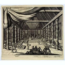
t Koonincklyck BANKET.
A decorative copperplate print of a diplomatic Dutch delegation, led by Van Hoorn, dining with a Chinese viceroy. A sumptuous feast is in progress, with many tables of fo...
Date: Amsterdam, J. van Meurs, 1663
Selling price: ????
Please login to see price!
Sold in 2016
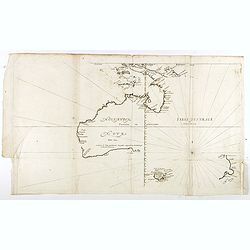
Hollandia Nova detecta 1644 , Terre Australe decouuerte l'an 1644.
Thevenot's map of Australia is the first published large-scale map of Australia and the first French map to record Tasman's 1642-1642 and 1644 discoveries in both Austral...
Date: Paris, Langlois, 1663
Selling price: ????
Please login to see price!
Sold in 2018
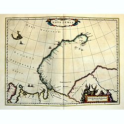
Nova Zemla.
The Dutch were the most persistent searchers after the north-east Passage, whether to the north of Novaya Zemlya (whose west coast is shown in detail) or through what the...
Date: Amsterdam, 1663
Selling price: ????
Please login to see price!
Sold in 2018
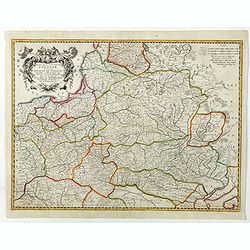
Estats De La Couronne De Pologne ou sont les Royaume de Pologne, Duches et Provinces De Prusse, Cuiave, Mazovie, Russie Noire &c Duches De Lithuanie, Volhynie Podolie &c. De L'Ukraine &c.
A very decorative and detailed map of Poland, Lithuania, Latvia, Belarus and Ukraine with decorative cartouche in the upper left corner showing two wind heads, a cheetah'...
Date: Amsterdam, 1663
Selling price: ????
Please login to see price!
Sold in 2018
The Duchy of Oswiecim, in Original Color. Oswiecim (Auschwitz)/ Zator/ Poland. Ducatus Oswiezensis et Zatoriensis.
A beautiful example of Joan Blaeu’s map of the upper Vistula river valley, in beautiful original color in the characteristic style of the house of Blaeu. The region cen...
Date: Amsterdam, 1663
Selling price: ????
Please login to see price!
Sold in 2019
Estats De La Couronne De Pologne ou sont les Royaume de Pologne, Duches et Provinces De Prusse, Cuiave, Mazovie, Russie Noire &c.
Fine map of Poland, state with erased date. Engraved by J.Sommer.Nicolas Sanson was to bring about the rise of French cartography, although the fierce competition of the ...
Date: Paris, 1663
Selling price: ????
Please login to see price!
Sold in 2025
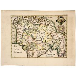
The Mughal Empire. India/ Afghanistan. Description de la partie des Indes orientales qu est sous la domination du grand Mogol.
A very scarce, attractive map of the Mughal or Mogul Empire that at its height controlled much of India and Afghanistan from early in the 16th century; it gradually dwind...
Date: Paris, 1663
Selling price: ????
Please login to see price!
Sold in 2019
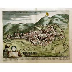
Assisi; Patria di St. Francesco
Folio-size hand-colored copper engraving with a city view of Assisi (semi bird’s eye view). Bottom left a scrolling cartouche (not filled in). Extensive legend at the ...
Date: Amsterdam, 1663
Selling price: ????
Please login to see price!
Sold in 2020
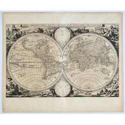
Orbis terrarum tabula recens emendata et in lucem edita per N. Visscher.
A scarce first state of this double hemisphere world map from the Elzevier Dutch bible printed in 1663 (Dutch text on verso). Surrounded by allegorical scenes of the cont...
Date: Amsterdam, 1663
Selling price: ????
Please login to see price!
Sold in 2019
Deze Caerte van den Uittocht der kinderen Israels..
Rare wood block map, depicting the exodus from Egypt, from the final Dutch edition of Heinrich B¨nting's famous Itinerarium Sacrae Scripturae, a book mainly about...
Date: Amsterdam 1663
Selling price: ????
Please login to see price!
Sold
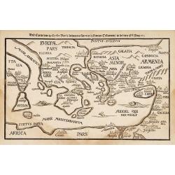
Deze Caerte van de henzen pauli..
Rare wood block map, depicting the Mediterranean, from the final Dutch edition of Heinrich Bünting's famous Itinerarium Sacrae Scripturae, a book mainly about th...
Date: Amsterdam 1663
Selling price: ????
Please login to see price!
Sold
Orbis Terrarum Tabula..
Magnificent double hemisphere Dutch Bible map. Surrounded by engravings of animals and four female allegorical representations of the continents. At top and bottom are tw...
Date: Amsterdam 1663
Selling price: ????
Please login to see price!
Sold
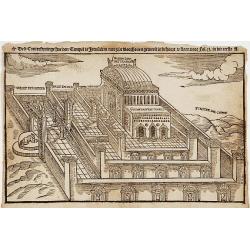
Dese Conterfentinge hoe den Tempel te Jerusalem
Rare wood block print, depicting the Solomon's Temple, from the final Dutch edition of Heinrich Bünting's famous Itinerarium Sacrae Scripturae, a book mainly about the H...
Date: Amsterdam 1663
Selling price: ????
Please login to see price!
Sold

Imperii Sinarum Nova Descriptio.
A most uncommon and scarce map of China, including Korea, Formosa (Taiwan) and Japan, published in the collection of Voyages "Relation de Divers Voyages Curieux"...
Date: Paris 1663
Selling price: ????
Please login to see price!
Sold
Geographifche Beschryvinghe van de Wandeling..
Title: "Geographifche Beschryvinghe van de Wandeling der Apostelen ende De Reysen Pauli"This is an original map from a Dutch bible of 1663 made by Visscher. col...
Date: Amsterdam 1663
Selling price: ????
Please login to see price!
Sold
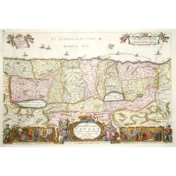
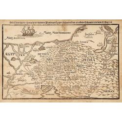
Het Beloofde Landt Canaan..
Title of the map: "Het Beloofde Landt Canaan door wandelt van onsen Salichmaecker Iesu Christo, neffens syne Apostelen"Fine map of Israel with north oriented to...
Date: Amsterdam 1663
Selling price: ????
Please login to see price!
Sold
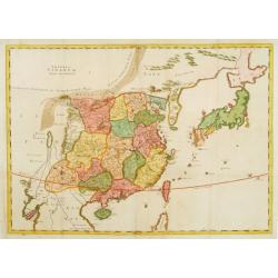
Imperii Sinarum Nova Descriptio
A scarce and extremely uncommon map of China. The work also includes Korea, Formosa (Taiwan) and Japan. It was published in the collection of Voyages, RELATION DE DIVER...
Date: Paris, 1663
Selling price: ????
Please login to see price!
Sold
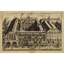
'T Oost Indisch Huys.
A decorative print of the East Indian House , the headquarters of the V.O.C., a place for meeting, trading and storage of spices and ship equipment.The maps and charts we...
Date: Amsterdam, J. van Meurs, 1663
Selling price: ????
Please login to see price!
Sold in 2015
Deze Caerte van de reysen Pauli..
Rare wood block map, depicting the Mediterranean, with an over-sized Cyprus from the final Dutch edition of Heinrich Bünting's famous Itinerarium Sacrae Scripturae, a bo...
Date: Amsterdam 1663
Selling price: ????
Please login to see price!
Sold
Novam Hanc TERRITORII FRANCOFURTENSIS Tabulam..
Map of Hessen, centred on Frankfurt and the river Main, bordered by design with arms and titles of 33 dignitaries, allegorical figures and cartouche shields with German E...
Date: Amsterdam 1663
Selling price: ????
Please login to see price!
Sold
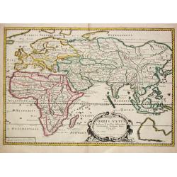
Orbis Vetus. A Paris. 1663.
Piere du Val (1618-83), Paris-based cartographer and publisher. Atlases a.o. ' Cartes de Géographie', 1654-88, ' La Géographie universelle' , 1661-1712. After his death...
Date: Paris, 1663
Selling price: ????
Please login to see price!
Sold
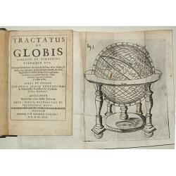
Tractatus de Globis coelesti et terrestri eorumque usu. Primum conscriptus a Roberto Hues Anglo atque iterum a Iudoce Hondio excusus?opera et studio J.I.Pontani?Adjicitur Brevarium totius orbis Terrarum Petri Bertii.
Small 8vo, 18 unnumb. leaves, 231 pp, old calf (rebacked). With 4 fold. engr. plates.First published in London in 1594 to accompany Emery Molyneux' globes. The text was r...
Date: Oxford, 1663
Selling price: ????
Please login to see price!
Sold
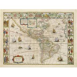
Americae Nova Tabula.
A wide paper copy, probably from his famous Atlas Major. The delineation of the coast and the nomenclature on both the Pacific and Atlantic coasts are basically Spanish i...
Date: Amsterdam, 1663
Selling price: ????
Please login to see price!
Sold in 2011
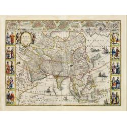
Asia noviter delineata.
A wide paper copy, probably from his famous Atlas Major. From 1633 the members of the Blaeu family were official cartographers to the United East India Company and, as su...
Date: Amsterdam 1663
Selling price: ????
Please login to see price!
Sold
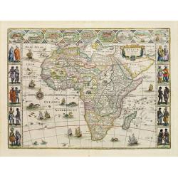
Africae nova descriptio.
A wide paper copy, probably from his famous Atlas Major. Much of the geographical information is still based on the Ptolemaic maps, with the Nile shown with its source in...
Date: Amsterdam 1663
Selling price: ????
Please login to see price!
Sold
De gelegentheyt van 't paradys..
Dutch Bible map covering the region between the Mediterranean and the Persian Gulf, featuring the Garden of Eden. Strapwork title cartouche flanked by scenes of Eve offer...
Date: Amsterdam 1663
Selling price: ????
Please login to see price!
Sold
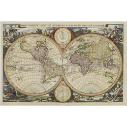
Orbis Terrarum Tabula..
Magnificent double hemisphere Dutch Bible map. Surrounded by engravings of animals and four female allegorical representations of the continents. At top and bottom are tw...
Date: Amsterdam, 1663
Selling price: ????
Please login to see price!
Sold
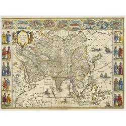
Asia noviter delineata.
With columns of figures on either side depicting the native manners of dress, and nine city plans and views at the top.Japan is shown accurately unusually with Korea as a...
Date: Amsterdam, 1663
Selling price: ????
Please login to see price!
Sold