Browse Listings
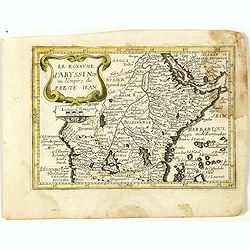
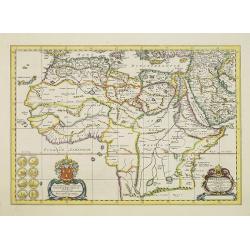
Le royaume d'Abyssinie ou l'Empire du Prete Iean. (14).
Scarce map of Abyssinia and Ethiopia published by Antoine de Fer in 1661 or 1662 in "Cartes de géographie revues et augmentées". With number 14 in lower right...
Date: Paris, Antoine de Fer, 1657 but 1661 or 1662
Selling price: ????
Please login to see price!
Sold in 2020
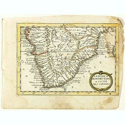
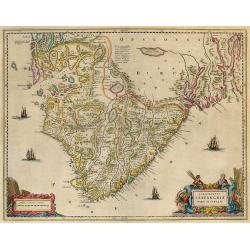
L'Empire du Monomotapa et coste des Caffres. (15).
Scarce map of Southern Africa published by Antoine de Fer in 1661 or 1662 in "Cartes de géographie revues et augmentées". With number 15 in lower right bottom...
Date: Paris, Antoine de Fer, 1657 but 1661 or 1662
Selling price: ????
Please login to see price!
Sold in 2018
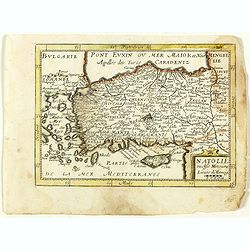
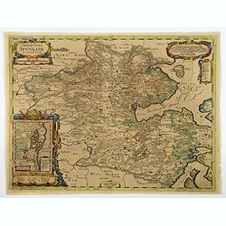
Natolie ou Asie Mineure. (16).
Scarce map of Turkey and Cyprus published by Antoine de Fer in 1661 or 1662 in "Cartes de géographie revues et augmentées". With number 16 in lower right bott...
Date: Paris, Antoine de Fer, 1657 but 1661 or 1662
Selling price: ????
Please login to see price!
Sold in 2020
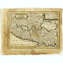
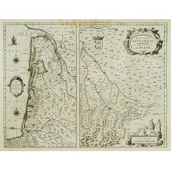
Terre Sainte jadis Terre Promise ou Palestine. (18).
Scarce map of Palestine published by Antoine de Fer in 1661 or 1662 in "Cartes de géographie revues et augmentées". With number 18 in lower right bottom of th...
Date: Paris, Antoine de Fer, 1657 but 1661 or 1662
Selling price: ????
Please login to see price!
Sold in 2021
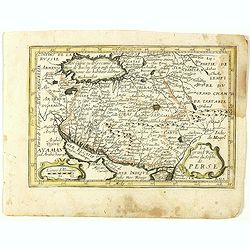
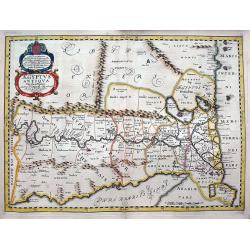
Le grand Royaume du Sophi de Perse. (19).
Scarce map of Persia, Afghanistan and part of Arabia published by Antoine de Fer in 1661 or 1662 in "Cartes de géographie revues et augmentées". With number 1...
Date: Paris, Antoine de Fer, 1657 but 1661 or 1662
Selling price: ????
Please login to see price!
Sold in 2018
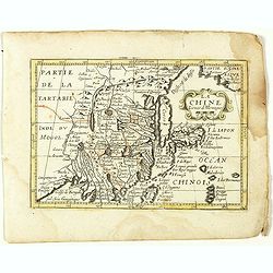
La Chine. (21).
Scarce map of China published by Antoine de Fer in 1661 or 1662 in "Cartes de géographie revues et augmentées". Korea shown as an island.With number 21 in low...
Date: Paris, Antoine de Fer, 1657 but 1661 or 1662
Selling price: ????
Please login to see price!
Sold in 2020
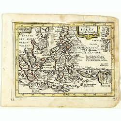
Les Isles des Indes Orientales. (23).
Scarce map of Indonesia and the Philippines published by Antoine de Fer in 1661 or 1662 in "Cartes de géographie revues et augmentées". With number 23 in lowe...
Date: Paris, Antoine de Fer, 1657 but 1661 or 1662
Selling price: ????
Please login to see price!
Sold in 2018
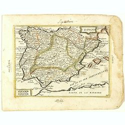
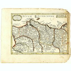
Espagne. (24).
Scarce map of Spain and Portugal published by Antoine de Fer in 1661 or 1662 in "Cartes de géographie revues et augmentées". With number 24 in lower right bot...
Date: Paris, Antoine de Fer, 1657 but 1661 or 1662
Selling price: ????
Please login to see price!
Sold in 2018
Portugal et Algarve. (25).
Scarce map of Portugal and Algarve published by Antoine de Fer in 1661 or 1662 in "Cartes de géographie revues et augmentées". With number 25 in lower right b...
Date: Paris, Antoine de Fer, 1657 but 1661 or 1662
Selling price: ????
Please login to see price!
Sold in 2021
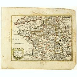
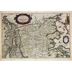
France Nouvellement descripte 1651. (26).
Scarce map of Africa in its second state published by Antoine de Fer in 1661 or 1662 in "Cartes de géographie revues et augmentées".With number 26 in lower ri...
Date: Paris, Antoine de Fer, 1657 but 1661 or 1662
Selling price: ????
Please login to see price!
Sold in 2019
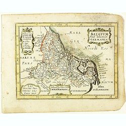
Belgium sive Inferior Germania. (27).
Scarce map of the Netherlands and Belgium published by Antoine de Fer in 1661 or 1662 in "Cartes de géographie revues et augmentées".With number 27 in lower r...
Date: Paris, Antoine de Fer, 1657 but 1661 or 1662
Selling price: ????
Please login to see price!
Sold in 2020
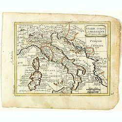
Italie Corse Sardaigne et Provinces adiacentes. (28).
Scarce map of Italy, Corsica and Sardinia published by Antoine de Fer in 1661 or 1662 in "Cartes de géographie revues et augmentées". With number 28 in lower ...
Date: Paris, Antoine de Fer, 1657 but 1661 or 1662
Selling price: ????
Please login to see price!
Sold in 2023
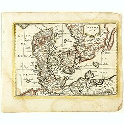
Danmarck. (30).
Scarce map of Denmark published by Antoine de Fer in 1661 or 1662 in "Cartes de géographie revues et augmentées". With number 30 in lower right bottom of the ...
Date: Paris, Antoine de Fer, 1657 but 1661 or 1662
Selling price: ????
Please login to see price!
Sold in 2018
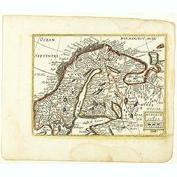
Norvege et Suede. (31).
Scarce map of Norway, Finland and Sweden published by Antoine de Fer in 1661 or 1662 in "Cartes de géographie revues et augmentées". With number 31 in lower r...
Date: Paris, Antoine de Fer, 1657 but 1661 or 1662
Selling price: ????
Please login to see price!
Sold in 2018
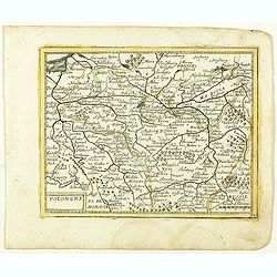
Polongne. (32).
Scarce map of Poland published by Antoine de Fer in 1661 or 1662 in "Cartes de géographie revues et augmentées". With number 32 in lower right bottom of the m...
Date: Paris, Antoine de Fer, 1657 but 1661 or 1662
Selling price: ????
Please login to see price!
Sold in 2018
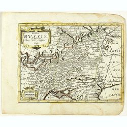
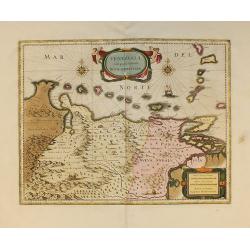
Grande Russie ou Blanche Avec ses confins 1651. (33).
Scarce map of Russia published by Antoine de Fer in 1661 or 1662 in "Cartes de géographie revues et augmentées". With number 33 in lower right bottom of the m...
Date: Paris, Antoine de Fer, 1657 but 1661 or 1662
Selling price: ????
Please login to see price!
Sold in 2018
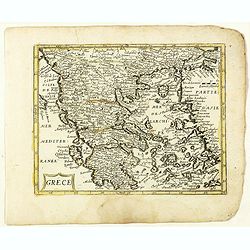
Grece. (36).
Scarce map of Greece published by Antoine de Fer in 1661 or 1662 in "Cartes de géographie revues et augmentées". The series of maps is largely derived from th...
Date: Paris, Antoine de Fer, 1657 but 1661 or 1662
Selling price: ????
Please login to see price!
Sold in 2019
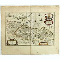
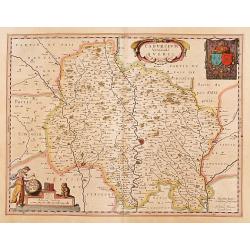
Lothian and Linlitquo.
This is a very detailed and striking map of the areas of Lothian and Linlithgow in Scotland. It is rare from Joan Blaeu's Atlas Major, with three added ships.The map cent...
Date: Amsterdam, 1662
Selling price: ????
Please login to see price!
Sold in 2018
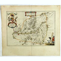
Nithia Vicecomitatus, The Shirifdome of Nidis-dail / auctore Timotheo Pont.
This is a detailed and striking map of the areas of Nidis-dail in Scotland. It is rare from Joan Blaeu's Atlas Major.Prepared by Timothy Pont and Robert Gordon. The map i...
Date: Amsterdam, 1662
Selling price: ????
Please login to see price!
Sold in 2019
![Carricta meridionalis, [vulgo], The South part of Carrick / auct. Timoth. Pont.](/uploads/cache/42489-250x250.jpg)
Carricta meridionalis, [vulgo], The South part of Carrick / auct. Timoth. Pont.
This detailed and striking map of the southern part of Carrick in Scotland is rare from Joan Blaeu's Atlas Major.Prepared by Timothy Pont and Robert Gordon. The map is en...
Date: Amsterdam, 1662
Selling price: ????
Please login to see price!
Sold in 2020
Cuninghamia / ex schedis Timotheo Pont , Ioannis Blaeu excudebat. Cunningham.
A very detailed map and a striking map of Cunningham in Scotland. Rare from Joan Blaeu's Atlas Major.Prepared by Timothy Pont and Robert Gordon. The map is enhanced by se...
Date: Amsterdam, 1662
Selling price: ????
Please login to see price!
Sold in 2019
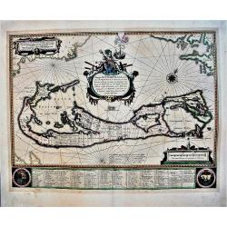
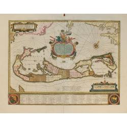
Mappa Aestivarum Insularum alias Barmudas.
An early, large, decorative map of the Bermudas by Blaeu, who based his map on the work of English cartographer John Speed, who produced a remarkably accurate map between...
Date: Amsterdam, 1662
Selling price: ????
Please login to see price!
Sold in 2021
Aegyptus Antiqua Divisa in Nomos Authore P. Duval. . .
A decorative map of ancient Egypt oriented with West at the top. Very detailed map, showing the Nile River, Red Sea, Pyramids, and much more information. Also shows sever...
Date: Amsterdam, ca. 1662
Selling price: ????
Please login to see price!
Sold in 2018
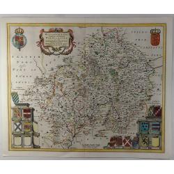
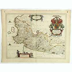
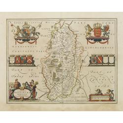
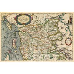
Wigorniensis Comitatus et Comitatus Warwicensis, nec non Coventrae libertas.
A beautifully, detailed 1662 French Edition of the Blaeu copper engraved map of Worcestershire and Warwickshire. The map provides excellent topographic details on cities,...
Date: Amsterdam, 1662
Selling price: ????
Please login to see price!
Sold in 2019
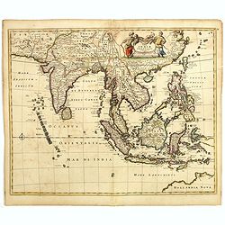
Tabula Indiae Orientalis.
An attractive and decorative map covering all South East Asia engraved by Johannes Lhuilier. The map encompasses the region from India to Southern China, Taiwan and the P...
Date: Amsterdam, 1662
Selling price: ????
Please login to see price!
Sold in 2020
Praefectura Apenrade et Luntoft herde.
This highly decorative and map of southern Denmark centres on the town of Aabenraa. This historical map is from the famous Atlas Maior published in Amsterdam in 1662. The...
Date: Amsterdam, 1662
Selling price: ????
Please login to see price!
Sold in 2021
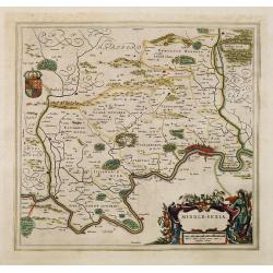
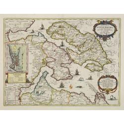
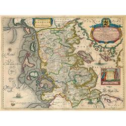
Middle-sexia.
Double-page map of the old Middlesex County, including a marvelous depiction of London on the Thames in the lower right corner. Decorative cartouche and coat of arms. Lat...
Date: Amsterdam, 1662
Selling price: ????
Please login to see price!
Sold in 2024
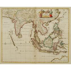
Tabula Indiae Orientalis.
An attractive and decorative map covering all South East Asia engraved by Johannes Lhuilier. The map encompasses the region from India to Southern China, Taiwan and the P...
Date: Amsterdam, 1662
Selling price: ????
Please login to see price!
Sold in 2011
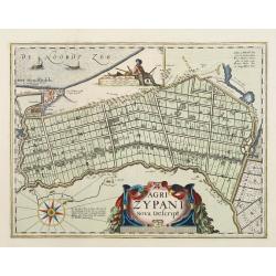
Agri Zypani Nova Descript.
Fine map of the region of the Zype. From a Latin text edition of the Atlas Maior.The copperplate was originally by Petrus Kearius, but was considerably revised by Joan Bl...
Date: Amsterdam, 1662
Selling price: ????
Please login to see price!
Sold in 2011
Cadurcium vernaculé Querci.
Detailed map of a province of France by one of the most famous map publisher. Centered on Cahors. In the lower left corner, a colored scale cartouche surmounted by a monk...
Date: Amsterdam 1662
Selling price: ????
Please login to see price!
Sold
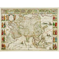
Asia noviter delineata..
From 1633 the members of the Blaeu family were official cartographers to the United East India Company and, as such, had access to the most up-to-date cartographic inform...
Date: Amsterdam 1662
Selling price: ????
Please login to see price!
Sold

Title page from
Attractive title page of Johan Blaeu's Atlas Major. Very decorative, and finely engraved with allegorical representation, showing Cybele, the Mater Deum Magna Idea (Great...
Date: Amsterdam, 1662
Selling price: ????
Please login to see price!
Sold
Carte du Bourdelois../ Principatus Benearnia..
Two maps on one sheet. The left map is centered on Bordeaux. Depicting The Garonne, The Arcachon basin and the country of the Landes. Also showing Bayonne. Embellished wi...
Date: Amsterdam 1662
Selling price: ????
Please login to see price!
Sold

Title page from
Attractive title page of Johan Blaeu's Atlas Major. Very decorative, and finely engraved with allegorical representation, showing Cybele, the Mater Deum Magna Idea (Great...
Date: Amsterdam, 1662
Selling price: ????
Please login to see price!
Sold in 2008
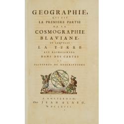
Title page from <I>Geographia Blaviana</I> with printer's device.
Title page from Johan Blaeu's Atlas Major. In bottom printer's device in color. Indefessus Agendo.
Date: Amsterdam 1662
Selling price: ????
Please login to see price!
Sold
Paris.
Extremely rare plan of Paris prepared by Jean Sauvé. Jean Sauvé used the earlier plans of Merian, Tavernier, Jollain, Bertrant, Huart and Lagniet. However this edition ...
Date: Paris, 1662
Selling price: ????
Please login to see price!
Sold
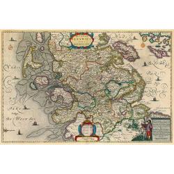
Montgomeria Comitatus et Comitatus Mervinia.
Double-page map of Montgomery shire and Merionethshire counties, Eastern and Western Wales. With elaborate title cartouche, distance scale and coats of Arms, including th...
Date: Amsterdam, 1662
Selling price: ????
Please login to see price!
Sold in 2013
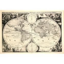
Orbis Terrarum Typus De Integro in Plurimis Emandatus, Auctus, Et Incunculis Illustratus.
Very RARE WORLD MAP FROM DUTCH BIBLE. The map has the same title as the early Visscher bible-world maps (Shirley 401 and 414), it has the same decorations in the 4 corner...
Date: Gorkum, H. van Kapel en I.B. Smient, 1662
Selling price: ????
Please login to see price!
Sold
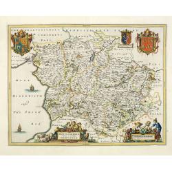
Nottinghamshire.
Map of the county of Nottinhgamshire from the spanish edition of the Atlas Major of Blaeu. Very nice original coloring with heightening of gold in the cartouches and cre...
Date: Amsterdam 1662
Selling price: ????
Please login to see price!
Sold
Ducatus Sleswici Pars Borealis. Johannnes Mejerus Husum.
Johan Blaeu succeeded his father Willem when the latter died in 1638. Johan led the Blaeu firm to its greatest achievement, the ' Atlas Maior' in 12 parts, the greatest a...
Date: Amsterdam, 1662
Selling price: ????
Please login to see price!
Sold
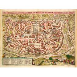
De Heylige en wyt vermaerde stadt Jerusalem eerst genaemt Salem.
Joshua Offerman's plan of Jerusalem is a close copy of the second state of the plan by Claes Jansz Visscher. The fisherman above the legende bottom left has been substitu...
Date: Gorkum, 1662
Selling price: ????
Please login to see price!
Sold
![Itroductio. [with Compass rose.]](/uploads/cache/23701-250x250.jpg)
Itroductio. [with Compass rose.]
Introduction leaf from a French text edition of Atlas Major
Date: Amsterdam 1662
Selling price: ????
Please login to see price!
Sold in 2008
![Itroductio. [with sphere.]](/uploads/cache/23702-250x250.jpg)
Itroductio. [with sphere.]
Introduction leaf from a Latin text edition of Atlas Major
Date: Amsterdam, 1662
Selling price: ????
Please login to see price!
Sold in 2014

Title page : \'Segunda Parte De Los Paises Baxos..\'
Attractive title page with gold highlights. The title is printed on a paste-on slip surrounded by the coats of arms of 9 provinces. From a rare Spanish text edition.
Date: Amsterdam, 1662
Selling price: ????
Please login to see price!
Sold
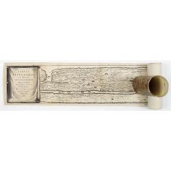
Tabula Itineraria ex illustri Peutingerorum Bibliotheca Quae Auguste Vindelicorum.
Eight sheets making up the famous Peutinger Table, or a Roman road map of the world. The map depicts the imperial roads and posts within the Roman Empire throughout Europ...
Date: Amsterdam, 1662
Selling price: ????
Please login to see price!
Sold
Africae Antiquae, et quarundam Europae Asiaeque Adiacentium Regionum, accurata delineatio, ad Historiarum lucem edita a Nicolao Blancardo, Batavo, Leidensi, Historiarum et Politices Professore.
Historical map of the Northern part of Africa dedicated to Nikolaas Blankaart (1624-1703). Published in a Latin text edition of J. Janssonius' Historical Atlas from 1662.
Date: Amsterdam, 1662
Selling price: ????
Please login to see price!
Sold in 2011
Ducatus Sonderborg cum adiacentibus Territoriis Alssen, Sundewitt, et Luxburgh.
With an inset of the castle and plan of Sonderborg. Engraved by the brothers Hus and Petersen. Prepared by Johannes Mejer ( 1606-1674), who surveyed the duchies of Schles...
Date: Amsterdam, 1662
Selling price: ????
Please login to see price!
Sold in 2011
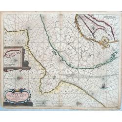
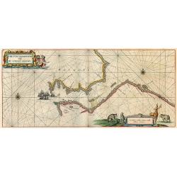
Pascaerte van de Mont van de Witte Zee tot aen de Rivier van Archangel . . .
Rare sea chart of the White Sea.
Date: Amsterdam, 1662
Selling price: ????
Please login to see price!
Sold in 2014
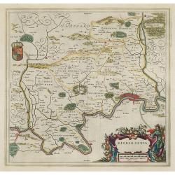
Middle-sexia.
Double-page map of the old Middlesex County, including a marvelous depiction of London on the Thames in the lower right corner. Decorative cartouche and coat of arms. Lat...
Date: Amsterdam, 1662
Selling price: ????
Please login to see price!
Sold in 2009
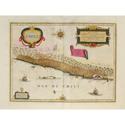
Chili.
Willem Blaeu's very decorative map of Chili with two large and beautiful cartouches, a compass and ships.First edition of the last part of the Latin "Atlas maior&quo...
Date: Amsterdam, 1662
Selling price: ????
Please login to see price!
Sold in 2010
Regiones Sub Polo Arctico
Nice copy of Blaeu's North Pole map. Latin text on verso.
Date: Amsterdam, 1662
Selling price: ????
Please login to see price!
Sold in 2009
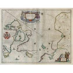
Fretum Nassovium vulgo De Straet Nassou
Nice copy of Blaeu's map of the Nassau Strait in the northern part of Russsia. Latin text on verso.
Date: Amsterdam, 1662
Selling price: ????
Please login to see price!
Sold in 2009
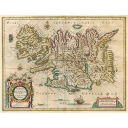
Tabula Islandiae
Nice copy of Blaeu's Iceland map. Latin text on verso.
Date: Amsterdam, 1662
Selling price: ????
Please login to see price!
Sold in 2009
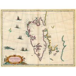
Spitsberga.
Nice copy of Blaeu's map of Spitsbergen.
Date: Amsterdam, 1662
Selling price: ????
Please login to see price!
Sold in 2009
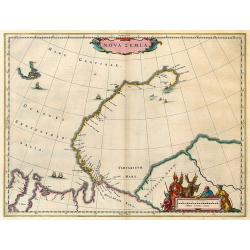
Nova Zemla.
Nova Zembla from Blaeu's Major Atlas. Latin text on verso.
Date: Amsterdam, 1662
Selling price: ????
Please login to see price!
Sold in 2009
Ducatus Sleswicum sive Iutia Australis.
Map of the area of Schleswig from Blaeu's Major atlas. Latin text on verso.
Date: Amsterdam, 1662
Selling price: ????
Please login to see price!
Sold in 2009
Ducatus Sleswici Pars Borealis.
Decorative map of North Schleswig from Blaeu's Major atlas. Latin text on verso.
Date: Amsterdam, 1662
Selling price: ????
Please login to see price!
Sold in 2010
Ducatus Slewici pars Meridionalis.
South Schleswig from Blaeu's Major atlas.
Date: Amsterdam, 1662
Selling price: ????
Please login to see price!
Sold in 2010
Episcopatus Stavangriae pars Australis.
South Stavanger from Blaeu's Major atlas.
Date: Amsterdam, 1662
Selling price: ????
Please login to see price!
Sold in 2009
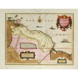
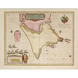
Guiana sive Amazonum Regio.
First edition of the last part of the Latin "Atlas maior" dedicated to America.Nice map extending from the Isla Margarita in the northwest to the coast of north...
Date: Amsterdam, 1662
Selling price: ????
Please login to see price!
Sold in 2009
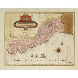
Peru.
First edition of the last part of the Latin "Atlas maior" dedicated to America.Decorated with ships and monsters on the sea. Orientated with east at the top. A ...
Date: Amsterdam, 1662
Selling price: ????
Please login to see price!
Sold in 2009
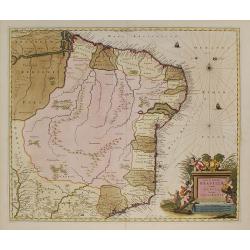
Nova et Accurata Brasiliae totius tabula.
First edition of the last part of the Latin "Atlas maior" dedicated to America. Original color.
Date: Amsterdam, 1662
Selling price: ????
Please login to see price!
Sold in 2010
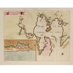
Sinus Omnium Sanctory.
Shows the area of Bahia de Todos Sanctos in north-east Brazil with an inset plan of San Salvador.First edition of the last part of the Latin "Atlas maior" dedic...
Date: Amsterdam, 1662
Selling price: ????
Please login to see price!
Sold in 2009
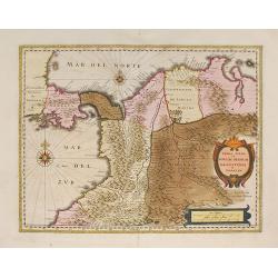
Terra Firma et Novum Regnum Granatense et Popayan.
Fine copy with wide margins of this handsome map of modern-day Panama and Colombia.First edition of the last part of the Latin "Atlas maior" dedicated to Americ...
Date: Amsterdam, 1662
Selling price: ????
Please login to see price!
Sold in 2009
Tabula Magellanica.
A map of South America's extremity with the Strait of Magellan and Le Maire Strait.The coastlines are depicted as very mountainous, while the interior is completely witho...
Date: Amsterdam, 1662
Selling price: ????
Please login to see price!
Sold in 2009
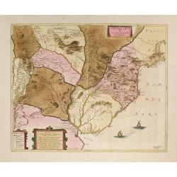
Paraquaria vulgo Paraguay.
Detailed map of Uruguay, Paraguay, Northern part of Argentina and northern part of Chilli. Engraved by Gerard Coeck. Two Dutch ships in the Atlantic Ocean.First edition o...
Date: Amsterdam, 1662
Selling price: ????
Please login to see price!
Sold in 2009
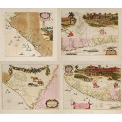
Praefecturae Paranambucae Pars Borealis. . . / Praefecturae Paranambucae Pars Meridionalis... / Praefectura de Ciriii ... / Praefecturae de Paraiba ...
Matching set of four maps covering the Brazilian Capitanias. Latin text on verso. First edition of the last part of the Latin "Atlas maior" dedicated to America...
Date: Amsterdam, 1662
Selling price: ????
Please login to see price!
Sold in 2009
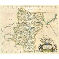
Huquang Imperii Sinarum Provincia Septima.
Decorative map of the seventh Chinese province 'Huquang', ornated with the typical high decorative ornated title cartouche together with an ornated mileage scale. The map...
Date: Amsterdam, 1662
Selling price: ????
Please login to see price!
Sold in 2010
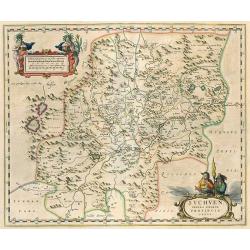
Suchuen Imperii Sinarum Provincia Sexta.
Province map of China from the Atlas Sinensis. Decorative map of the sixth Chinese province 'Suchuen', ornated with the typical high decorative ornated title cartouche to...
Date: Amsterdam, 1662
Selling price: ????
Please login to see price!
Sold in 2010
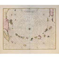
Canibales Insulae.
Rare, early Dutch nautical chart of the Caribbean from Puerto Rico southward, from the first edition of the last part of the Latin "Atlas maior" dedicated to Am...
Date: Amsterdam, 1662
Selling price: ????
Please login to see price!
Sold in 2011
Mappa Aestivarum Insularum, alias Barmudas...
From the first edition of the last part of the Latin "Atlas maior" dedicated to America.Blaeu based his work on John Speed's remarkably accurate map of 1626-162...
Date: Amsterdam, 1662
Selling price: ????
Please login to see price!
Sold in 2010
Venezuela, cum parte Australi novae Andalusiae.
From the first edition of the last part of the Latin "Atlas maior" dedicated to America.A finely engraved, decorative map. The islands Trinidad, Margarita, Arub...
Date: Amsterdam, 1662
Selling price: ????
Please login to see price!
Sold in 2010
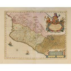
Nova Hispania et Nova Galicia.
From the first edition of the last part of the Latin "Atlas maior" dedicated to America, and based on Ortelius's map of 1579 which became the basis for many of ...
Date: Amsterdam, 1662
Selling price: ????
Please login to see price!
Sold in 2010
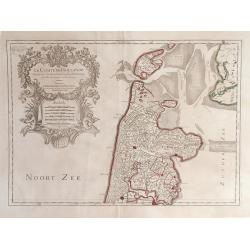
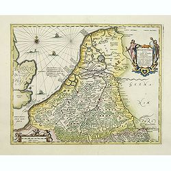
Le Comte de Hollande.
Map of northern Holland by Jaillot after Sanson; shows Amsterdam at the very bottom.
Date: Paris, 1662
Selling price: ????
Please login to see price!
Sold in 2010
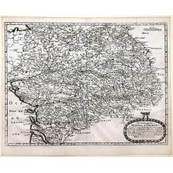
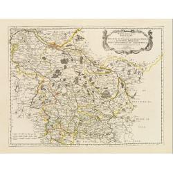
Government General d'Orleans.
Map of Orleans in northern central France, along the Loire River in the Loire Valley from the atlas "Topographia Galliae". This map also shows many regions of F...
Date: Frankfurt, 1662
Selling price: ????
Please login to see price!
Sold in 2010
Cenomanorum Galliae regionis typus Vulgo Le Mans.
Beautifully colored map of the region surrounding Le Mans, in northwest France, published by the Blaeu firm. Accompanying Dutch text on verso.Born in Alkmaar, Holland, Wi...
Date: Amsterdam, 1662
Selling price: ????
Please login to see price!
Sold in 2010

Tractus Borysthenis vulgo Dniepr et Niepr Dicti, à Chortika Ostro ad Urbem Oczakow . . .
This superb map shows the upper part of the Dnieper River in two horizontal strips, the upper map with a compass rose orienting the map, west to the top. It is richly emb...
Date: Amsterdam, 1662
Selling price: ????
Please login to see price!
Sold
Belgii Veteris Typus ex Conatibus Geographicis Abrahami Ortelii. . . Petrus Kaerius Caelavit.
Ancient map of present Netherlands, Belgium and Luxemburg. Title cartouche on the upper right corner, giving credit to Abraham Ortelius. Engraved by Petrus Kaerius.
Date: Amsterdam, 1662
Selling price: ????
Please login to see price!
Sold in 2011
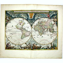
Nova et Accuratissima Totius Terrarum Orbis Tabula.
Since its appearance as an Appendix in 1630, the atlas launched by Willem Blaeu and continued by his son Joan had expanded greatly. But in spite of many new regional maps...
Date: Amsterdam, 1662
Selling price: ????
Please login to see price!
Sold in 2011
Tabula Itineraria ex illustri Peutingerorum Bibliotheca. . .
Eight maps (on 4 sheets) making up the famous Peutinger Table, or a Roman road map of the world. The map depicts the imperial roads and posts within the Roman Empire thro...
Date: Amsterdam, 1662
Selling price: ????
Please login to see price!
Sold in 2011