Browse Listings

Interior de la Catedral de México, . . .
Two-shades plate taken from : México y sus alrededores (Mexico, Decaen, Portal del Coliseo Viejo, 1855-1856). With a key in English, Spanish and French.
Date: Mexico,1855-1856
Selling price: ????
Please login to see price!
Sold in 2011
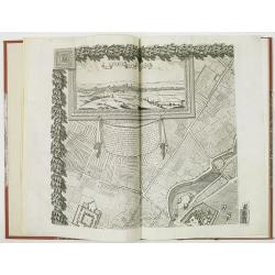
Plan de Paris - Paris
PRINTED ON VELLUM. Large nine panel plan of Paris, if joined height: 52 inches (1321 mm). width: 58 inches (1473 mm). This is the 1856 edition etched by E.Lebel for "...
Date: Paris, Société des Bibliophiles, 1856
Selling price: ????
Please login to see price!
Sold

Road from Tacubaya to Chapultepec. Dresses of Mexivan Indians. - Camino de Tacubaya a Chapultepec. Trajes de Indios Mexicanos.
The plate has caption title in English, Spanish and French, from the rare publication MEXICO Y SUS ALREDEDORES, the most elaborate and important Mexican lithographic book...
Date: Mexico, Establecimiento Litografico de Decaen, 1855-1856
Selling price: ????
Please login to see price!
Sold in 2020
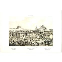
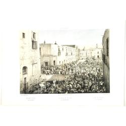
Iturbide Market Old St. John square. - El Mercado de Iturbide Antiqua plaza de San Juan.
The plate has caption title in English, Spanish and French, from the rare publication MEXICO Y SUS ALREDEDORES, the most elaborate and important Mexican lithographic book...
Date: Mexico, Establecimiento Litografico de Decaen, 1855-1856
Selling price: ????
Please login to see price!
Sold in 2016
College of miners. - Collegio de mineria.
College of miners. The plate has caption title in English, Spanish and French, from the rare publication MEXICO Y SUS ALREDEDORES, the most elaborate and important Mexica...
Date: Mexico, Establecimiento Litografico de Decaen, 1855-1856
Selling price: ????
Please login to see price!
Sold in 2012
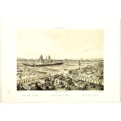
Public square of Mexico. - Plaza de armas de México.
The plate has caption title in English, Spanish and French, from the rare publication MEXICO Y SUS ALREDEDORES, the most elaborate and important Mexican lithographic book...
Date: Mexico, Establecimiento Litografico de Decaen, 1855-1856
Selling price: ????
Please login to see price!
Sold

Square of Ste. Domingo. - Plaza de Santo Dimingo.
The plate has caption title in English, Spanish and French, from the rare publication MEXICO Y SUS ALREDEDORES, the most elaborate and important Mexican lithographic book...
Date: Mexico, Establecimiento Litografico de Decaen, 1855-1856
Selling price: ????
Please login to see price!
Sold in 2020
Public square of Mexico. - Plaza de armas de México.
The plate has caption title in English, Spanish and French, from the rare publication MEXICO Y SUS ALREDEDORES, the most elaborate and important Mexican lithographic book...
Date: Mexico, Establecimiento Litografico de Decaen, 1855-1856
Selling price: ????
Please login to see price!
Sold in 2020
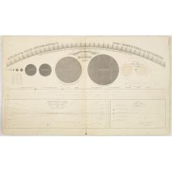
Atlas designed to illustrate Burritt's Geography of the Heavens. . .
Star Atlas with 8 charts, partially hand-colored. By the beginning of the nineteenth century more than one hundred thousand stars had been discovered.The Atlas designed t...
Date: Shendon, New York, 1856
Selling price: ????
Please login to see price!
Sold in 2013
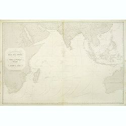
Carte générale de la Mer des Indes dressée apres les derniers documents Anglais Publiée par Robiquet . . .
A of the Indian Ocean, with its islands and adjacent coasts in detail. The chart stretches from the Congo coast, around Africa, Arabia, India and South East Asia, includ...
Date: Paris, 1856
Selling price: ????
Please login to see price!
Sold in 2011
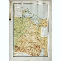
Percement de l'isthme de Suez. Atlas des cartes, plans, sondages, profils et forages à l'appuie du projet de la commission internationale. . .
Atlas from the third series only illustrated with 12 plates, maps, plans, sections and elevations, most folding.Surveys carried out in 1855 and 1856 in the Suez Isthmus f...
Date: Paris, aux bureaux de L'Isthme de Suez, Henri Plon, 1856
Selling price: ????
Please login to see price!
Sold in 2020
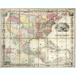
United States of America the British Provinces, Mexico...
Large engraved folding map surrounded by a decorative grapevine border interspersed with twelve insets and a large American eagle in front of a port. The map's coverage ...
Date: New York, 1856
Selling price: ????
Please login to see price!
Sold in 2019
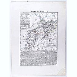
Impero di Marocco.
An interesting and uncommon detailed and large-scale Italian map of Morocco. The Italian text below provides historical, political and commercial information. Published i...
Date: Naples, 1856
Selling price: ????
Please login to see price!
Sold in 2021
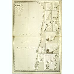
Carte des entrées de la Mer D'Irlande et du Canal de Bristol. . .
A large sea-chart of southern Ireland and parts of Cornwall and Wales. With numerous old pencil notes. colored yellow dots indicate the fire signals along the coasts. Wit...
Date: Paris, 1856
Selling price: ????
Please login to see price!
Sold in 2020

Whampoa Pagoda & Anchorage.
A lithographic illustration from the Narrative of The Expedition of an American Squadron to the China Seas and Japan, Performed in the Years 1852, 1853 and 1854, under th...
Date: New York, 1856
Selling price: ????
Please login to see price!
Sold in 2020
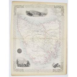
Van Diemen's Island or Tasmania.
Double page steel engraved map of Tasmania. Three vignette including one of Hobart Town. Decorative scrolling and title cartouche to the edges of the image. For the Great...
Date: London & New York: John Tallis & Company, 1856
Selling price: ????
Please login to see price!
Sold in 2020
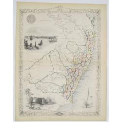
New South Wales.
Double page steel engraved map. With vignette illustrations of Sydney Cove and The Murray. Two other illustrations of the Seal of New South Wales and the plant XanthorrÃ...
Date: London & New York: John Tallis & Company, 1856
Selling price: ????
Please login to see price!
Sold in 2020
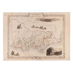
Victoria or Port Phillip.
24.5 x 32.5 cm. Original outline color. Steel engraved map. Five vignette illustrations including Melbourne. Decorative scrolling and title cartouche to the edges of the ...
Date: London & New York: John Tallis & Company, 1856
Selling price: ????
Please login to see price!
Sold in 2023

Jesuit Convent in Macao.
In the August of 1853, Commodore Perry departed Lew Chew for China. His first stop was in Macao, where he took a house for an extended stay. This lithograph is a view of ...
Date: New York, 1856
Selling price: ????
Please login to see price!
Sold in 2020
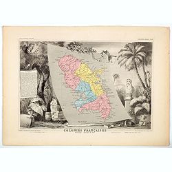
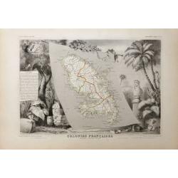
Colonies Francaises - Martinique Amerique du Sud.
A beautiful map from one of the finest decorative atlases of the nineteenth century. The map is surrounded with engravings depicting the countryside with trade goods incl...
Date: Paris, 1856
Selling price: ????
Please login to see price!
Sold in 2020

China Girl. Sycee head Dress.
A lithograph taken from a daguerreotype from Commodore M.C. Perry's' Narrative of the Expedition of an American Squadron to the China Seas and Japan, Performed in the Yea...
Date: Philadelphia, ca 1856
Selling price: ????
Please login to see price!
Sold in 2020
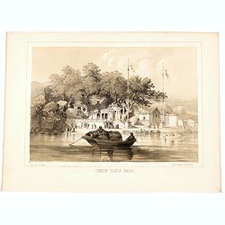
Chinese Temple, Macao.
A pleasant view of the important Chinese Temple in Macao.
Date: Philadelphia, 1856
Selling price: ????
Please login to see price!
Sold in 2020
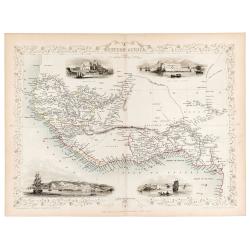
Western Africa.
Original steel engraved map of Western Africa. Map accompanied by vignette scenes of Christiansborg, Cape Coast Castle, Sierra Leone and Bakel. Decorative scrolling and t...
Date: London & New York: John Tallis & Company, 1856
Selling price: ????
Please login to see price!
Sold in 2023
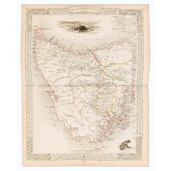
Van Diemen's Island or Tasmania.
Original steel engraved map of Tasmania. Three vignettes including one of Hobart Town. Decorative scrolling and title cartouche to the edges of the image. (Map 22 x 29.5 ...
Date: London / New York: J. / F. Tallis, 1856
Selling price: ????
Please login to see price!
Sold in 2023
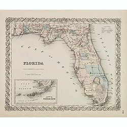
FLORIDA.
First edition. Issue with decorative borders. Fine map of Florida with smaller inset map "Plan of the Florida Keys". Of particular interest is the Arredondo Gra...
Date: New York, c. 1856
Selling price: ????
Please login to see price!
Sold in 2014
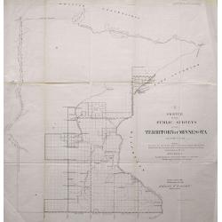
LOT OF 2: SKETCH OF THE PUBLIC SURVEYS IN THE TERRITORY OF MINNESOTA & SKETCH OF THE PUBLIC SURVEYS IN WISCONSIN AND TERRITORY OF MINNESOTA
Pair of lithographed maps of Minnesota and Wisconsin showing the Township boundaries for 1856. Included are rivers and towns.
Date: 1856
Selling price: ????
Please login to see price!
Sold in 2013
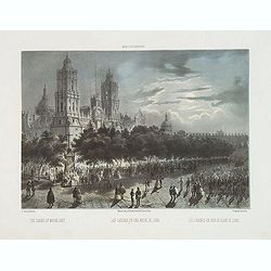
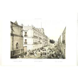
Las Cadenas en una noche de luna. - The Chains by Moonlight.
The Chains by Moonlight. The plate has caption title in English, Spanish and French, from the rare publication México y sus alrededores, the most elaborate and important...
Date: Mexico, Establecimiento Litografico de Decaen, 1855-1856
Selling price: ????
Please login to see price!
Sold in 2015
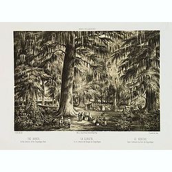
La Glorieta, en el interior del bosque de Chapultepec. - The Bower. In the interior of the Chapultepec Park.
The Bower. In the interior of the Chapultepec Park. The plate has caption title in English, Spanish and French, from the rare publication México y sus alrededores, the m...
Date: Mexico, Establecimiento Litografico de Decaen, 1855-1856
Selling price: ????
Please login to see price!
Sold in 2013
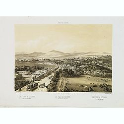
La villa de Tacubaya, Tomada desde Chapultepec. - The town of Tacubaya. Taken from Chapultepec.
The town of Tacubaya, seen from Chapultepec. The plate has caption title in English, Spanish and French, from the rare publication México y sus alrededores, the most ela...
Date: Mexico, Establecimiento Litografico de Decaen, 1855-1856
Selling price: ????
Please login to see price!
Sold in 2013
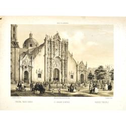
Principal Parish Church - El Sagrario de México. - Paroisse principale.
Fine lithographed plate of the Metropolitan Cathedral of the Assumption of Mary of Mexico City. The plate has caption title in English, Spanish and French, from the rare ...
Date: Mexico, Establecimiento Litografico de Decaen, 1855-1856
Selling price: ????
Please login to see price!
Sold in 2020
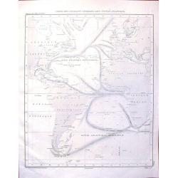
Carte des Courants Generaux dans L'Ocean Anlantique.
Fine lithographed sea chart by Depot des Cartes et Plans de la Marine featuring the sea currents in the Atlantic Ocean. It was engraved by Jacobs from drawings by Charles...
Date: Paris, 1856
Selling price: ????
Please login to see price!
Sold in 2016

A set of 15 humorous prints from the Russian Empire's war with the French and British Empire's.
This set of 15 are from 1847 - 1856. Mostly engraved by Joseph Swain. Joseph Swain was one of the most important woodblock engravers. Punch was responsible for the word s...
Date: London 1847 - 1856
Selling price: ????
Please login to see price!
Sold in 2015

A set of 15 humorous prints from the Russian Empire's war with the French and British Empire's.
This set of 15 are from 1846 - 1856. Mostly engraved by Joseph Swain. Joseph Swain was one of the most important woodblock engravers. Punch was responsible for the word s...
Date: London 1846 - 1856
Selling price: ????
Please login to see price!
Sold in 2015

A set of 16 humorous woodblock prints from the Russian Empire's war with the French and British Empire's.
This set of 16 are from 1853 - 1856, mostly engraved by Joseph Swain. Joseph Swain was one of the most important woodblock engravers.Punch was responsible for the word se...
Date: London, 1853 - 1856
Selling price: ????
Please login to see price!
Sold in 2015
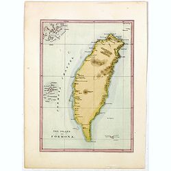
The island of Formosa.
This is the first American lithograph of Taiwan. Published by Ackerman. More about Taiwan or Ilha-Formosa maps. [+]
Date: New York, 1856
Selling price: ????
Please login to see price!
Sold in 2016
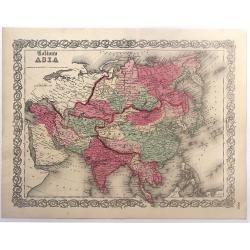
Colton's Asia.
Colton's map of Asia. The map covers the entire continent from the Mediterranean to Siberia and from the Arctic to Singapore. Tibet, Korea and Ladak within the borders o...
Date: New York, 1856
Selling price: ????
Please login to see price!
Sold in 2017
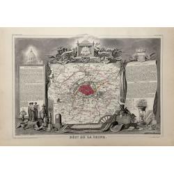
Dépt. De La Seine. - Paris.
A Decorative map of Paris, including the region of Versailles.Beautiful map from one of the finest decorative atlases of the nineteenth century. This attractive map is fr...
Date: Paris, 1856
Selling price: ????
Please login to see price!
Sold in 2017
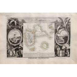
Colonies Françaises. Martinique. Amérique du Sud.
Beautiful map from one of the finest decorative atlases of the nineteenth century. The map is surrounded with engravings depicting the countryside with trade goods includ...
Date: Paris 1856
Selling price: ????
Please login to see price!
Sold in 2016
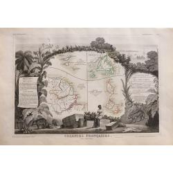
Colonies Françaises (en Amérique).
Beautiful map from one of the finest decorative atlases of the nineteenth century. A highly decorative 19th century map showing the islands of St Martin, St Pierre et Miq...
Date: Paris 1856
Selling price: ????
Please login to see price!
Sold in 2016
Colonies Francaises en Amérique: Guadeloupe, Marie-Galante, St Martin, La Désirade, Les Saintes, Anguilla.
Beautiful map from one of the finest decorative atlases of the nineteenth century. A highly decorative 19th century map showing the islands of Guadeloupe, Marie-Galante, ...
Date: Paris 1856
Selling price: ????
Please login to see price!
Sold in 2016
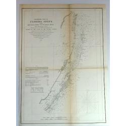
Preliminary Chart of Florida Keys from Key Biscayne to Pickles Reef
Detailed chart of Florida reefs with soundings. From a Trigonometrical Survey under the direction of A.D. Bache, Superintendent of the Survey of the coast of the United S...
Date: New York, 1856
Selling price: ????
Please login to see price!
Sold in 2018
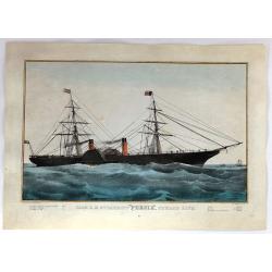
Iron R.M. Steamship “Persia”_ Cunard Line - Currier
Fine colored lithograph or chromolithograph featuring the steamship Persia of the Cunard Line. It was produced in about 1838 by Currier & Ives and is signed in print ...
Date: New York, 1856
Selling price: ????
Please login to see price!
Sold in 2017
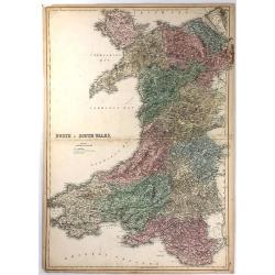
North & South Wales.
This large map is of NORTH & SOUTH WALES. The map is from the 1856 edition of Black's “General Atlas of the World”. The map displays the provinces (of that time) ...
Date: Edinburgh, 1856
Selling price: ????
Please login to see price!
Sold in 2016
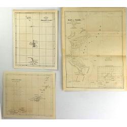
(Three Perry Maps) Bay of Yedo, Chart of the Bonin Group of Islands & Great Lew Chew.
These are quaint original antique maps from "Narrative of an Expedition of an American Squadron to the China Seas and Japan" by Commodore M.C. Perry.
Date: Washington, 1854-1856
Selling price: ????
Please login to see price!
Sold in 2016
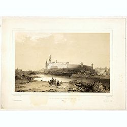
Vue du château de Cracovie, le 17 mars 1840. (Wawel Castle)
Fine depiction of Wawel Castle.Lithographed by Barthélémy Lauvergne and printed by Lemercier. Published by Arthus Bertrand of Paris who worked together with Ackermann i...
Date: Paris, Lemercier, 1852-1856
Selling price: ????
Please login to see price!
Sold in 2021
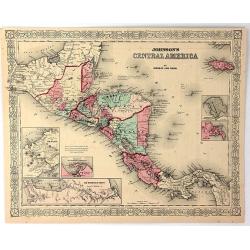
Johnson's Central America
A very pleasing map of Central America and Jamaica. Original hand colors surrounded by the usual fretwork border. From "Johnson's Atlas" by Johnson & Ward.
Date: New York, 1856
Selling price: ????
Please login to see price!
Sold in 2017

Four lithographic scenes from the Crimean War.
Four lithographic scenes from the Crimean War, based on sketches by William Simpson, which were published in London by Paul and Dominic Colnaghi & Co.- The Charge of ...
Date: London, 1856
Selling price: ????
Please login to see price!
Sold in 2017
A set of 8 maps from The Crimea War.
A set of 8 maps from The Crimea War 1856. By W. & A.K Johnston, published by W & R Chambers London 1856. The titles: 'Portion of The Crimea Forming Chief Scene of...
Date: London, 1856
Selling price: ????
Please login to see price!
Sold in 2016
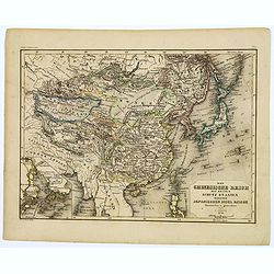
Das Chinesische Reich mit seinen Schutz Staaten...Japanischen Insel Reiche.
A map of the Chinese and Japanese Empires published during the middle of the nineteenth century by Grassl, a German cartographer and engraver, who part worked in collabor...
Date: Hildburghausen, 1856
Selling price: ????
Please login to see price!
Sold in 2017
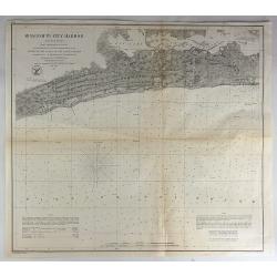
Reconnaissance of Steilacoom Harbor, Washington Ter.
Original lithograph of the U.S. Coast Survey map of Steilacoom Harbor, Washington Territory from 1856. It is from a trigonometrical survey under the direction of A.D. B...
Date: Washington, 1856
Selling price: ????
Please login to see price!
Sold in 2018
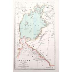
The Aral Sea according to Khanikoff. . .
An interesting map of the former Aral Sea between Kazakhstan and Uzbekistan has dried up since 2014. Published in the very influential Petermanns geographische Mitteilung...
Date: London, ca. 1856
Selling price: ????
Please login to see price!
Sold in 2018
A New Map of the United States of America By J.H. Young.
Uncommon 1856 edition of Charles Desilver's map of the United States, illustrating the evolving American West. Includes explanation and notes. Shows capital of states and...
Date: Philadelphia, 1856
Selling price: ????
Please login to see price!
Sold in 2018
The vilage of Ixtacalco. Taken from a balloon. El pueblo de Ixtacalco Tomado en globo. Le village d'Ixtacalco Pris en ballon.
The village of Ixtacalco, taken from a balloon. The plate has caption title in English, Spanish and French, from the rare publication MEXICO Y SUS ALREDEDORES, the most e...
Date: Mexico, Establecimiento Litografico de Decaen, 1855-1856
Selling price: ????
Please login to see price!
Sold in 2018
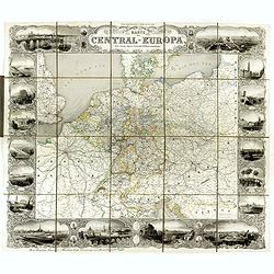
Karte von Central-Europa.
Steel engraved wall map printed from 4 plates by Albert Henry Payne, active in Leipzig and Dresden, dated 1856.Showing The Low Countries, Germany, Prussia, Poland, Denmar...
Date: Leipzig, Dresden, 1856
Selling price: ????
Please login to see price!
Sold in 2018
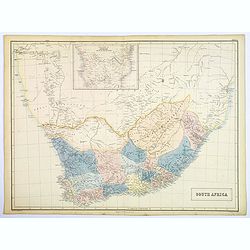
South Africa.
A large map of South Africa with considerable detail; it includes modern day Botswana, Namibia and Mozambique.
Date: Edinburgh, 1856
Selling price: ????
Please login to see price!
Sold in 2018
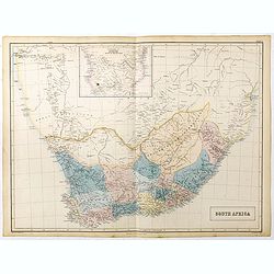
South Africa.
A large map of South Africa with considerable detail, it includes modern day Botswana, Namibia and Mozambique. Inset map at upper centerfold of 'Continuation of Africa so...
Date: Edinburgh, 1856
Selling price: ????
Please login to see price!
Sold in 2023

Cruxbay (St. Jan).
A beautiful view of Crux bay on the island St. John. This view shows much of the town and surrounding area. One of a series of six lithographs of St. Thomas produced by t...
Date: Copenhagen, Baerentzen & Co, 1856
Selling price: ????
Please login to see price!
Sold in 2019
St. Jan.
A beautiful view on the island St. John. This view shows a planter and 2 locals cooking on a fire. One of a series of six lithographs of St. Thomas produced by the publis...
Date: Copenhagen, Baerentzen & Co, 1856
Selling price: ????
Please login to see price!
Sold in 2019
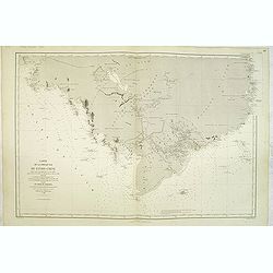
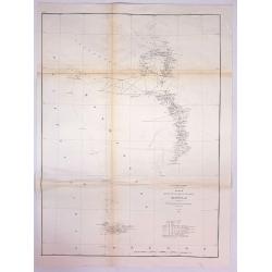
Carte des côtes du Chili et de la Bolivie dressée d'après les Traveux du Cap.e Fitz-Roy par Robiquet . . .
Large chart of the coast of Chili, with 11 detailed insets. Engraved by Louis A. Sengteller.
Date: Paris, 1857
Selling price: ????
Please login to see price!
Sold in 2012
Carte de la presque'ile de L'Indo-Chine. . . jusqu'à l'entrée de la Rivière de Bang-Kok dans le Golfe de Siam. . .
Large chart of the southern tip of Cambodia, including the region of present-day Ho Chi Mihn City, etc. Engraved by Louis A. Sengteller.Two light houses colored in red an...
Date: Paris, 1857
Selling price: ????
Please login to see price!
Sold in 2012
![Environs Of London [. . .] Windsor Castle to Gravesend.](/uploads/cache/92787-250x250.jpg)
Environs Of London [. . .] Windsor Castle to Gravesend.
Engraved by John Dower. An extremely detailed map of the vicinity of London, as it was in 1855 when this map was published. Many vignettes showing scenes in and around Lo...
Date: London, 1857
Selling price: ????
Please login to see price!
Sold in 2014

A set of 16 humorous woodblock prints from the Russian Empire's war with the French and British Empire's.1853 - 1857.
This set of 16 are from This set of 16 are from 1853 - 1857, mostly engraved by Joseph Swain. Joseph Swain was one of the most important woodblock engravers. Punch was re...
Date: London, 1853 -1857
Selling price: ????
Please login to see price!
Sold in 2015
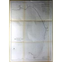
Preliminary Chart of Monterey Bay California.
Antique Electrotype Map, published in 1857 in Washington for the "Report of the Superintendent of the U.S. Coast Survey..." Published under the supervision and ...
Date: Washington, 1857
Selling price: ????
Please login to see price!
Sold in 2016
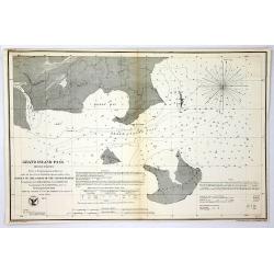
Grand Island Pass, Mississippi.
Antique Electrotype Map Published 1843-65, Washington for "Report of the Superintendent of the U.S. Coast Survey..." Published under the supervision and directi...
Date: Wahsington, 1857
Selling price: ????
Please login to see price!
Sold in 2016
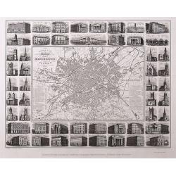
Illustrated Plan of Manchester and Salford.
Uncommon "carte à figures"- city plan of Manchester. Very detailed with street names, and a legend naming 51 buildings with their building date. The map is sur...
Date: Manchester, 1857
Selling price: ????
Please login to see price!
Sold in 2016
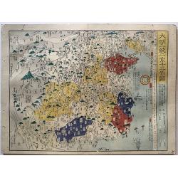
Historical atlas of China throughout the successive dynasties Or Sina rekidai enkaku zu.
A beautiful woodblock atlas of China. Maps were originally made by the great Japanese cartographer, Nagakubo Sekisui, with this edition published by Ninomiya. There are...
Date: Osaka,1857
Selling price: ????
Please login to see price!
Sold in 2017
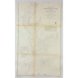
Preliminary Chart of Rappahannock River Virginia From Entrance to Deep Creek.
An informative large U.S. Coast Survey nautical chart of Virginia's Rappahannock River. It covers the course of the Rappahannock River from the Chesapeake Bay to Deep Cre...
Date: Washington, 1857
Selling price: ????
Please login to see price!
Sold in 2018
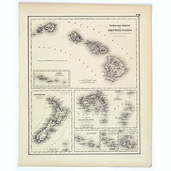
Hawaiian Group or Sandwich Islands.
This is Colton's map of Hawaii, New Zealand, and several Polynesian island groups. The sheet has seven separate maps. The top map,which occupies the top half of the sheet...
Date: New York, ca. 1857
Selling price: ????
Please login to see price!
Sold in 2017
Sketch K Showing the Progress of the Survey in Section No. XI (Upper Sheet) from Tillamook Bay to the Boundary.
A fine 1857 US Costal Survey map, or triangulation chart, of Washington State, from Tillamook Head to Vancouver Island, including Juan De Fuca Strait, the Puget Sound, Ol...
Date: Washington, 1857
Selling price: ????
Please login to see price!
Sold in 2017
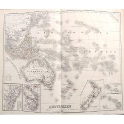
Australien.
Richly detailed map of Australia and the Pacific. Extends from Indonesia until California and names hundreds of islands in the Great Ocean. Australia is called Austral As...
Date: Weimar, 1857
Selling price: ????
Please login to see price!
Sold in 2017
Mississippi Harbor.
Original lithograph of the U.S. Coast Survey map of Mississippi Harbor, Mississippi from 1857. It is from a trigonometrical survey under the direction of A.D. Bache Supe...
Date: Washington, 1857
Selling price: ????
Please login to see price!
Sold in 2018
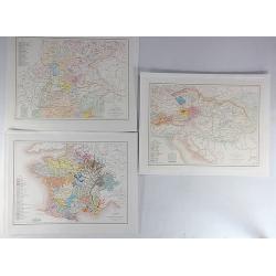
Carte de L'Empire D'Autriche Pour Servir a L'Histoire des Races Bovines (3 Maps.)
An interesting set of three maps showing the species of cow in France, Austria and Germany. Each map has a legend with a color code representing each species. Published b...
Date: Paris, 1857
Selling price: ????
Please login to see price!
Sold in 2019
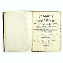
Atlante della Guida generale per la navigazione delle coste settentrionali ed orientali dell' America de Sud dal Rio della Plata al Parà...
A good example of the first edition, extra illustrated. The Atlante is a rare and important collection of lithographed charts, plans, and city views of the Atlantic coast...
Date: Naples, Caro Batelli, 1857
Selling price: ????
Please login to see price!
Sold in 2018
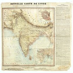
Nouvelle carte de l'Inde pour suivre les opérations militaires dans les possessions anglaises .
Very detailed map of India, printed on very thin paper. With inset plan of Delhi. In dedicate original hand colors. In lower right inset map of the Western Hemisphere, &q...
Date: Paris, ca. 1857
Selling price: ????
Please login to see price!
Sold in 2021

Provincie Limburg
Decorative and uncommon costume plate lithographed by R. de Vries and published by Frans Buffa & Zonen in Amsterdam. Published in Bing, Nederlandsche kleederdragten .
Date: Amsterdam 1857
Selling price: ????
Please login to see price!
Sold
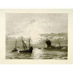
Shipping scene.
Attractive lithography showing Dutch vessels off the Dutch coast, by A.A.Nunnink after a painting by L.Meijer. Published in Kunst Kroniek .
Date: The Hague, 1857
Selling price: ????
Please login to see price!
Sold in 2024
Carta dell' America settentrionale.
Uncommon Italian map with the Republic of Texas, the United States extending into present-day Canada, Russia in control of Alaska. Map is in outlined color.Many Indian na...
Date: Turin 1857
Selling price: ????
Please login to see price!
Sold
Carta dell' Oceania 1857
Uncommon Italian map of Australia, New Zealand, Indonesia and the Pacific till Mexico. Map is in outlined color.Many Indian names and settlements.From Geografia Storica a...
Date: Turin, 1857
Selling price: ????
Please login to see price!
Sold in 2012
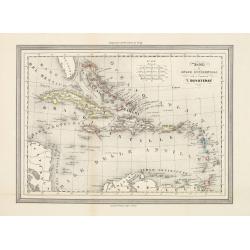
Antille od Indie Occidentali per il geografo T.Duvoteney.
Uncommon Italian map of Caribbean. Map is in outlined color.Many Indian names and settlements.From Geografia Storica and published by Fratelli Doyen in Turin.
Date: Turin, 1857
Selling price: ????
Please login to see price!
Sold in 2023
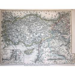
Die Asiatische Türkey 1854.
A superbly steel-engraved map from the rare German Atlas: Meyer's Zeitungs-Atlas, considered to be the finest German Atlas of the mid 19th century! Revised edition for th...
Date: Hildburghausen, 1857
Selling price: ????
Please login to see price!
Sold