Browse Listings
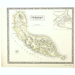
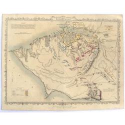
A detailed map of the island of Curaçao.
A detailed map of the island of Curaçao showing settlements, roads, and the topography. An inset shows Fort Amsterdam with the battery, gallows, and fortifications.
Date: Liverpool, George Philip and Son, 1853
Selling price: ????
Please login to see price!
Sold in 2022
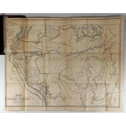
Map of the Valley of the Amazon To Accompany Lt. Herndon's Report.
This is one of three maps that accompanied Herndon's report, “Exploration of the Valley of the Amazon”. In 1851, Lieutenant Herndon was commissioned to lead the first...
Date: Baltimore, 1853
Selling price: ????
Please login to see price!
Sold in 2018
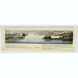
Stretto di Gibilterra.
The bottom half of a two view sheet by Corbetta. (The missing view is that of the Dardanelles in Turkey.) This colored view is that of the Strait of Gibraltar. With Itali...
Date: Milano, 1853
Selling price: ????
Please login to see price!
Sold in 2020
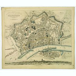
Frankfort.
A detailed plan of the German city of Frankfort, published by the Society for the Diffusion of Useful Knowledge. Streets and prominent buildings shown in great detail, to...
Date: London, 1853
Selling price: ????
Please login to see price!
Sold in 2020

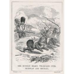
A set of 10 humorous prints from the Russian Empire's war with French and British Empire's. c1854.
Ten humorous prints with the following titles: 1.The United Service 18542. The Soldiers Dream 18543. The Shooting Season 18544. God Defend The Right 18545. You Are reques...
Date: London, 1854
Selling price: ????
Please login to see price!
Sold in 2012

A set of 15 humorous prints from the Russian Empire's war with French and British Empire's. c1854.
Mostly engraved by Joseph Swain. Joseph Swain was one of the most important wood engravers of his time. Punch was responsible for the word sense "cartoon" as a ...
Date: London, 1854
Selling price: ????
Please login to see price!
Sold in 2012
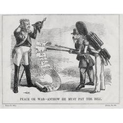
A set of 10 humorous prints from the Russian Empire's war with French and British Empire's. c1854
1.Peace or War – Anyhow he Must Pay the Bill 18542.Brothers in Arms 18543.Smoke 1854 4.A Struggle Between Duty and Inclination 1854 5.The Holiday Letter 18546.Sebastopo...
Date: London, 1854
Selling price: ????
Please login to see price!
Sold in 2012
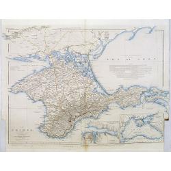
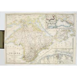
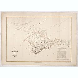
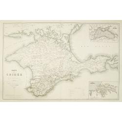
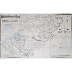
The Crimea, chiefly from surveys made by order of the Russian government. . .
Map of Crimea and the Sea of Azov. In lower right corner two inset maps showing Sebastopol inlet and harbour and a second one with the Black Sea. This second maps shows t...
Date: London, 1854
Selling price: ????
Please login to see price!
Sold in 2012
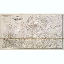
Carte des voies de cummunication de la Russie d'Erope et des etats voisins dressée par ordre se s.m. L'Empereur. . .
Detailed folding map of Northern part of Russia, prepared by L. Sagansan. The map is engraved on stone by the brothers Avril and printed by Kaeppelin in Paris.
Date: Paris, 1854
Selling price: ????
Please login to see price!
Sold in 2015
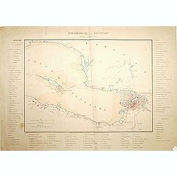
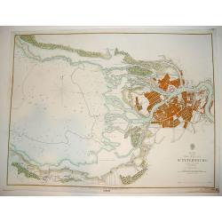
St.Petersbourg et Kronstadt.
Detailed map of the region with Kronstadt and St. Petersburg. Published by J. Correard, Directeur du journal des Sciences Militaires, R. Christine Dauphine a Paris . In l...
Date: Paris, 1854
Selling price: ????
Please login to see price!
Sold in 2013
The Crimea by James Wyld Geographer to the Queen & H.R.H. Prince Albert.
The second edition of this folding map of Crimea. In the upper right corner, an inset map of the areas around the Black Sea, "The Town & Harbor of Sevastopol wit...
Date: London, 1854
Selling price: ????
Please login to see price!
Sold in 2017
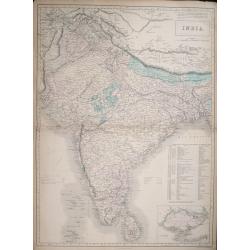
India.
Large detailed map of India by Sidney Hall published by A. &. C. Black in Edinburgh Steel engraving with original color Relief shown by hachures. States shown by tint...
Date: Edinburgh, 1854
Selling price: ????
Please login to see price!
Sold in 2014
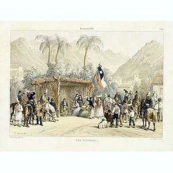
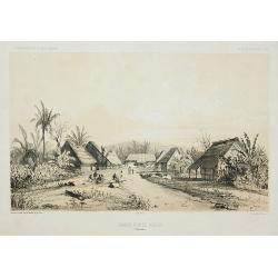
Historia de Chile. No. 20. Una chingana.
From "Historia de Chile." by Claudio Gay, a French naturalist, who was working under contract to the Chilean government between 1830-1833. Upon his return to Fr...
Date: Paris, 1854
Selling price: ????
Please login to see price!
Sold in 2014
The Russian & Ottoman Empires, Sweden, Denmark, Prussia & Austria.
Detailed map of Russia, Scandinavia, Turkey, Crimea and Black Sea and Caspian Sea. Including railway from Moscow to St. Petersburg.James Wyld (the younger) was geographer...
Date: London, 1854
Selling price: ????
Please login to see price!
Sold in 2017
Cronstadt in the Baltic with the fortifications, batteries's & range of the guns &c.
A rare map showing the area around Cronstadt, which was an island defense for St Petersburg. The map includes the range of guns in addition to the position of the fortifi...
Date: London, 1854
Selling price: ????
Please login to see price!
Sold in 2015
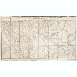
Carte pour suivre la marche de la guerre en Orient, dressée d'après les ordres de l'empereur: par L. Sagansan.
Detailed folding map of the theatre of war in the Balkans, Ukraine and around the Black Sea, indicating the Austrian, Russian and Turkish spheres of influence, prepared b...
Date: Paris, ca. 1854
Selling price: ????
Please login to see price!
Sold in 2019
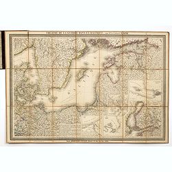
Theatre de la guerre dans la Baltique, par Mr. le Colonel LAPIE.
Excellent detailed folding map of the Baltic Sea. With inset map of Finland in lower right (195x185mm.) and inset plans of "Environs de Riga", "Plan de la ...
Date: Paris, 1854
Selling price: ????
Please login to see price!
Sold in 2014
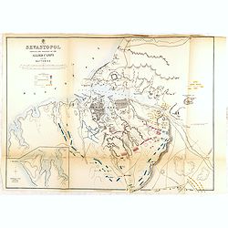
SEVASTOPOL showing the positions of the allied camps and the batteries. . . 5th edition.
Fifth edition of this fine and important single sheet lithographed plan in a scale of ca. 1:21 500 of Sevastopol. With some soundings and seabed contours. Scales in yards...
Date: London, 1854
Selling price: ????
Please login to see price!
Sold in 2014
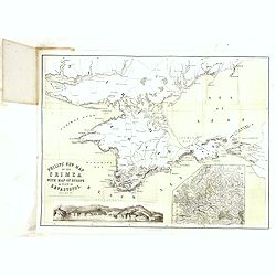
Philips' new map of the Crimea with map of Europe and view of Sevastopol.
A well-preserved copy of this charming folding map of Russia. In lower part an inset with a panoramic view of Sevastopol. To the lower right a map of Europe.
Date: London, 1854
Selling price: ????
Please login to see price!
Sold in 2014
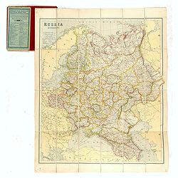
Philips' new map of the Crimea with map of Europe and view of Sevastopol.
A well-preserved copy of this charming folding map of Russia, Poland and the Baltic States. With charming original hardcover red wrapper richly decorated with flower desi...
Date: London, 1854
Selling price: ????
Please login to see price!
Sold in 2014
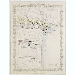
Plan of the battle of Alma.
An antique plan drawn and engraved by John Rapkin "from English and French Official Documents" Published 1858 by the London Printing and Publishing Co., London....
Date: London, 1854
Selling price: ????
Please login to see price!
Sold in 2020
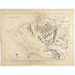
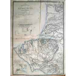
Siege of Sebastopol.
A detailed map of the Siege of Sebastopol. After the Battle of the Alma, the Allies proceeded to Sebastopol and commenced the Siege on September 26th, 1854. A steel engra...
Date: London, 1854
Selling price: ????
Please login to see price!
Sold in 2020
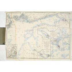
The Gulf of Finland and Baltic Sea with the fortified places from Stockholm to St.Petersburg. . . / Gulf of Bothia. / Cronstadt and St. Petersburg. . . / The harbour & entrances of Sweaborg and Helsingfors. . . Cronstadt. . .
Folding map of Gulf of Finland with several inset maps. James Wyld (the younger) was geographer to the Queen and H.R.H. Prince Albert. Joined his father's business in 183...
Date: London, 1854
Selling price: ????
Please login to see price!
Sold in 2015
Siege of Sebastopol.
Detailed steel engraving map of the Siege of Sebastopol. After the Battle of the Alma, the Allies proceeded to Sebastopol and commenced the Siege on September 26th, 1854....
Date: London, 1854
Selling price: ????
Please login to see price!
Sold in 2019
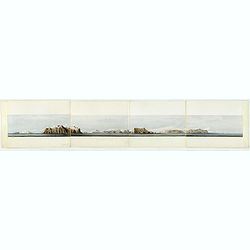
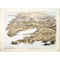
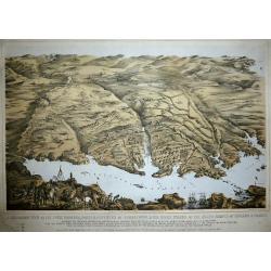
Panoramic view of the southern coast of the Crimea.
Panorama on 4 joint sheets. Impressive panorama showing the South-East coastline of Crimea from Kara-Dag and Koktebel to Feodosia, after a drawing by Captain W. H. Parker...
Date: London Dickinson, 1854
Selling price: ????
Please login to see price!
Sold in 2016
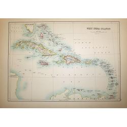
West India Islands
A superb map of the West Indies and the tip of Florida - Venezuela, drawn and engraved by William Hughes – Sidney Hall steel engraved. Published by Adam & Charles B...
Date: Edinburgh, 1854
Selling price: ????
Please login to see price!
Sold in 2016
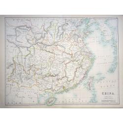
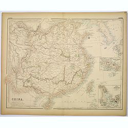
China
A highly detailed and attractive map of China drawn and engraved by William Hughes – Sidney Hall, steel engraved.Published by Adam & Charles Black in the ‘General...
Date: Edinburgh, 1854
Selling price: ????
Please login to see price!
Sold in 2016
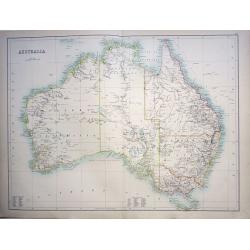
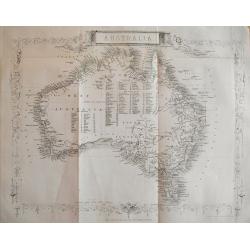
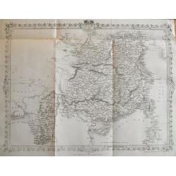
Australia
A highly detailed and attractive map of Australia drawn and engraved by William Hughes – Sidney Hall, steel engraved.Published by Adam & Charles Black in the ‘Gen...
Date: Edinburgh, 1854
Selling price: ????
Please login to see price!
Sold in 2016
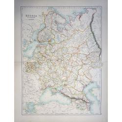
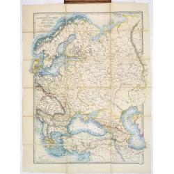
Russia in Europe
A highly detailed and attractive map of European Russia engraved by William Hughes – Sidney Hall, steel engraved.Published by Adam & Charles Black in the ‘General...
Date: Edinburgh, 1854
Selling price: ????
Please login to see price!
Sold in 2019
Carte de la Crimée dressée par D. RAMÉE, auteur du Plan de Sévastopol - 1854.
Uncommon map of Crimea, printed by Trinocq in Paris. Extensive legends in lower right corner.
Date: Paris, Garnier Frères Libraires, 1854
Selling price: ????
Please login to see price!
Sold in 2016
China.
A lovely, large map of China, with insets the Island of Chusan, and the Estuary of the Canto River from Hong Kong to Canton. Korean peninsula shown. Good detail and excel...
Date: Edinburgh, 1854
Selling price: ????
Please login to see price!
Sold in 2018
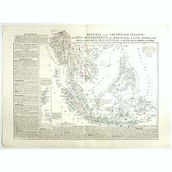
Malesia ossia Arcipelago Indiano, ed India-Transgangetica.
Attractive map of the Southeast Asia with inset map: Arcipelago di Andaman, Arcipelago di Nicobar. A wealth of information listing his cartographic sources and giving pol...
Date: Naples, 1848-1854
Selling price: ????
Please login to see price!
Sold in 2017
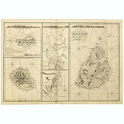
A New chart of Island of France or MAURITIUS by J.N. Norie, 1832. The island of Bourbon, called also Mascarenthas.
Five charts on one sheet, including " A New chart of Island of France or MAURITIUS", "The island of Bourbon, called also Mascarenthas", "Plan of ...
Date: London, 1854
Selling price: ????
Please login to see price!
Sold in 2018
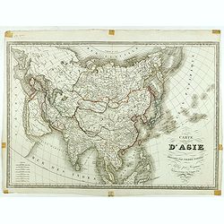
Carte d'Asie dressée par Pierre Tardieu . . .
Large map of Asia published by Édouard-Auguste-Patrice Hocquart (1789-1870?)He succeeded the print dealer Basset at rue Saint-Jacques before 1836. Engraver, he invents i...
Date: Paris, Hocquart, 1854
Selling price: ????
Please login to see price!
Sold in 2024
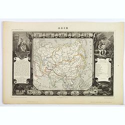
Asie.
A decorative 19th-century map of the continent. The map is surrounded by numerous steel engraved vignettes, all depicting costumes of the various peoples of Asia, Adam an...
Date: Paris, 1854
Selling price: ????
Please login to see price!
Sold in 2021
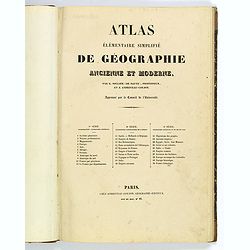
Atlas elementaire simplifie de geographie ancienne et moderne.
French school atlas, with title page, complete with 30 double page maps: Maps 1-10 Cosmographie, Geographie Generale. Maps 11-20 Geographie Particulaire de l'Europe. Maps...
Date: Paris, ca 1854
Selling price: ????
Please login to see price!
Sold in 2020

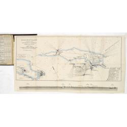
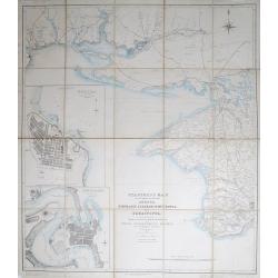
The town & harbour of Sevastopol with the batteries & approaches. . .
Rare colored linen backed map showing the harbour and town of Sevastopol, with soundings. In upper left corner a inset map (65x150mm) of the Black Sea. In bottom part a l...
Date: London, March 27th, 1854
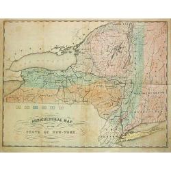
Agricultural Map of the State of New York.
A thematic map of New York State.
Date: New York, c. 1854
Selling price: ????
Please login to see price!
Sold in 2013
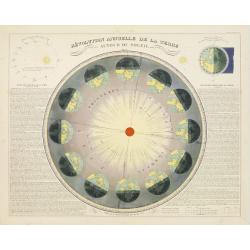
Revolution Annuelle De La Terre.
Colorful astronomical chart showing the annual succession of seasons, from winter to spring. Notes the positions of the earth during the Solstices and Equinoxes. Closer t...
Date: Paris, 1854
Selling price: ????
Please login to see price!
Sold in 2009
The Bay of St. Petersburg
A very rare British Admiralty nautical chart of the Bay of St. Petersburg, engraved by J & C Walker. Licensed to J. D. Potter as agent for the British Admiralty Char...
Date: Dated 1854
Selling price: ????
Please login to see price!
Sold

Théatre de la Guerre en Orient 1854.
Detailed map depicting the progress of the war in the Ukraine, the Crimea and the Black Sea. Including Istanbul lower left. Centered on the Black Sea area, with the north...
Date: Paris, 1854
Selling price: ????
Please login to see price!
Sold in 2009
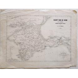
Kaart van de Krim of Taurië, (oudtijds Chersonesus Taurica).
Map of the southern part of Ukrain, between the Sea of Azov, The Black Sea, Karkinyts'ka Gulf and the Nogaic desert. After H.J.N. Huot.With the capitals, towns, villages,...
Date: Utrecht, 1854
Selling price: ????
Please login to see price!
Sold in 2013

Village d\'Umata (Ile Gouaham).
Two-shades plate engraved for the "Atlas Pittoresque - Voyage au Pôle Sud et dans l'Océanie, sur les corvettes l'Astrolabe et la Zélée, exécuté par ordre du Ro...
Date: Paris, 1841-1854
Selling price: ????
Please login to see price!
Sold in 2011
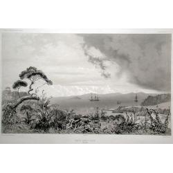
Baie de Sarah's Bosom (Iles Auckland)
Plate engraved for the "Atlas Pittoresque - Voyage au Pôle Sud et dans l'Océanie, sur les corvettes l'Astrolabe et la Zélée, exécuté par ordre du Roi pendant l...
Date: Paris, 1841-1854
Selling price: ????
Please login to see price!
Sold in 2008

Vue de l'Observatoire.
Two-shades plate engraved for the "Atlas Pittoresque - Voyage au Pôle Sud et dans l'Océanie, sur les corvettes l'Astrolabe et la Zélée, exécuté par ordre du Ro...
Date: Paris, 1841-1854
Selling price: ????
Please login to see price!
Sold in 2010
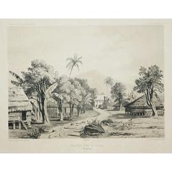
Grande rue d\'Umata.
Two-shades plate engraved for the "Atlas Pittoresque - Voyage au Pôle Sud et dans l'Océanie, sur les corvettes l'Astrolabe et la Zélée, exécuté par ordre du Ro...
Date: Paris, 1841-1854
Selling price: ????
Please login to see price!
Sold in 2011

Mouillage d'Otago.
Two-shades plate engraved for the "Atlas Pittoresque - Voyage au Pôle Sud et dans l'Océanie, sur les corvettes l'Astrolabe et la Zélée, exécuté par ordre du Ro...
Date: Paris, 1841-1854
Selling price: ????
Please login to see price!
Sold in 2010
Grande rue de Merizo.
Two-shades plate engraved for the "Atlas Pittoresque - Voyage au Pôle Sud et dans l'Océanie, sur les corvettes l'Astrolabe et la Zélée, exécuté par ordre du Ro...
Date: Paris, 1841-1854
Selling price: ????
Please login to see price!
Sold in 2011
Carte de la Crimée pour suivre les opérations de la Guerre d'Orient.
Uncommon map showing the Crimea region, published to follow the Crimean war. With inset maps "Carte des pays riverains de la Mer Noire" et "Port de Sevasto...
Date: Paris, Ernest Bourdin, 1854
Selling price: ????
Please login to see price!
Sold in 2010
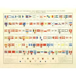
Pavillons et cocardes des principales puissances du globe d'après des Documents Officiels.
Very decorative originally hand colored chart of flags and rosettes of all sea fearing nations, prepared by J. Andriveau-Goujon and published in his "Atlas Universel...
Date: Paris, ca. 1854
Selling price: ????
Please login to see price!
Sold in 2012
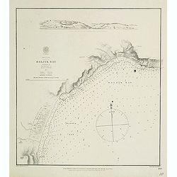
Black Sea - Baljik Bay surveyed by the officers of H.S.M.V. Spitfire 1854
of the Baljik Bay with in top a panoramic view of the town seen from the anchorage. The Baljik Bay is located in Southeastern Europe, bordering the Black Sea, between Ro...
Date: London, after 1854
Selling price: ????
Please login to see price!
Sold in 2017
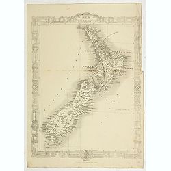
New Zealand.
Map of New Zealand, published by "The London Printing and Publishing Company". Drawn and engraved by John Rapkin.
Date: London, 1854
Selling price: ????
Please login to see price!
Sold in 2022
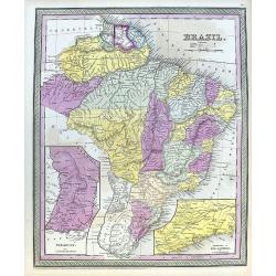
Brazil.
A fine map of Brazil, from Guiana and Venezuela in the north to Uruguay and Buenos Aires in the south. Filled with places names and also some reference to Indians. Two in...
Date: Philadelphia, 1854
Selling price: ????
Please login to see price!
Sold in 2020
Asie
A decorative 19th century map of the continent. The map is surrounded by steel engraved vignettes depicting costumes of the various peoples of Asia, Adam and Eve, and sev...
Date: Paris, 1854
Selling price: ????
Please login to see price!
Sold in 2020
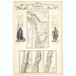
West Coast of South America including Chile & part of Bolivia & Peru.
A decorative regional map of South America, which contains 4 maps. The top map shows Peru and the neighboring Bolivian Table Lands, while and the 3 maps at the bottom dep...
Date: Edinburgh, 1854
Selling price: ????
Please login to see price!
Sold in 2020
Map of the Punjab: western Himalaya and adjoining parts of Tibet from recent Surveys, and based upon the Trigonometrical survey of India, . . .
Rare separately published map of the Western Himalayas, Tibet and part of Punjab, published as part of the Great Trigonometrical Survey of India. The map was issued by th...
Date: London, W.H. Allen & Co., 1854
Selling price: ????
Please login to see price!
Sold in 2021

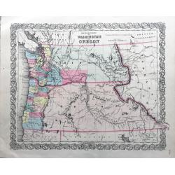
Map of the States of California, Washington, Utah, New Mexico, & Oregon Territories
This map by one of the leading U.S. cartographic firms of the period, is an excellent example of American mapping at an important time in the development of the western U...
Date: Philadelphia, 1854
Selling price: ????
Please login to see price!
Sold in 2023
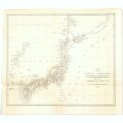
Map of the Japan Islands. . .complied by order of Commodore M.C. Perry, USN.
A map of Japan by Maury and Bent under the orders of Commodore Perry, 1855. Very good detail of the many islands with cities marked and with decent topographical informat...
Date: New York, 1855
Selling price: ????
Please login to see price!
Sold in 2020
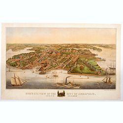
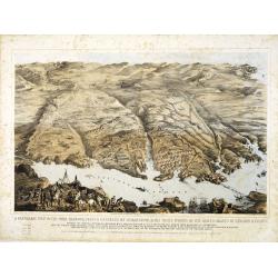
Bird's Eye View of the City of Annapolis, the Capitol of Maryland.
A wonderful large colored lithograph, by E. Sachse & Co., one of two important lithography companies operating in Baltimore during the mid nineteenth century, showing...
Date: Baltimore, ca 1855
Selling price: ????
Please login to see price!
Sold in 2020
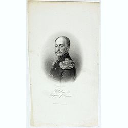
Nicholas I. Emperor of Russia.
Steel engraved portrait of Nicholas I (1796–1855), tsar and emperor of Russia from 1825 to 1855. Engraved by G.Cook and published by Regan Paul Trench.
Date: London, ca.1855
Selling price: ????
Please login to see price!
Sold in 2020
The Territories of Washington and Oregon.
Rare and early map of this region, in nice conditions.
Date: New York, 1855
Selling price: ????
Please login to see price!
Sold in 2022
Seat of War in the Krimea.
Steel engraved folding map of the Krimea with original hand color. With panoramic views of Sevastopol, Balaklava and Eupatoria from Anchorage. Maps of the Black Sea and a...
Date: London, 1855
Selling price: ????
Please login to see price!
Sold in 2012
Stanford's Map of the Roads &c. Between Odessa, Nikolaief, Perekop, Simfieropol, and Sebastopol.
Folding map of south-eastern Ukraine, focusing on the region between Odessa and just east of Balaklava. Large inset maps of Odessa and Nikolayev to left edge. The whole d...
Date: London, 1855
Selling price: ????
Please login to see price!
Sold in 2012

A set of 10 humorous prints from the Russian Empire's war with French and British Empire's.
Ten humoorous prints with the following titles: - Another Russian Victory!!! July 8th 1854. - The Russian Frankenstein and His Monster July 15th 1854. - The Real ...
Date: London 1854-1855
Selling price: ????
Please login to see price!
Sold in 2012
The Environs of Sevastopol with the Batteries & Approaches.
Large lithographed plan of the Siege of Sevastopol. Shows the surroundings of the city in great topographical detail, and all the troop locations. Also indicates roads, t...
Date: London, c1855
Selling price: ????
Please login to see price!
Sold in 2012
A set of 9 humorous prints from the Russian Empire's war with French and British Empire's.
Nine humorous prints with the following titles: - The Queen visiting the Imbeciles of the Crimea,1855- Cruel Treatment of Russian Prisoners in England,1854.- Bursting of ...
Date: London, 1854-1855
Selling price: ????
Please login to see price!
Sold in 2012

A set of 10 humorous prints from the Russian Empire's war with French and British Empire's.
Ten humorous prints with the following titles: 1.Tightening the Grip2.A Water Party3.Sir Edmund Lyons going in his Brougham to the Opera at Sebastopol4.Cruel Treatment of...
Date: London, 1854-1855
Selling price: ????
Please login to see price!
Sold in 2012
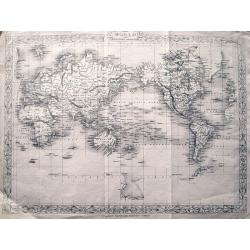
The World on Mercator's Projection.
Detailed map of the world. With suggested Antarctica! This is the uncommon and slightly later edition by Rapkin based on Tallis' maps. The vignettes have been removed....
Date: London, c.1855
Selling price: ????
Please login to see price!
Sold in 2013
A panoramic view of the town, harbour, forts & defences of Sebastopol & the siege works of the allied armies of England & France. . .
A panoramic town-plan of the town, harbour, forts and defenses of Sevastopol in Ukraine.Chromolithographed and designed by Thomas Packer, and published by Stannard and Di...
Date: London, 1855
Selling price: ????
Please login to see price!
Sold in 2013
![A Panoramic View of the Position now occupied by the Allied Armies before Sebastopol [. . .] sketched by command of the Emperor Louis Napoleon by an eminent officer of the French Imperial Engineers](/uploads/cache/33753-250x250.jpg)
A Panoramic View of the Position now occupied by the Allied Armies before Sebastopol [. . .] sketched by command of the Emperor Louis Napoleon by an eminent officer of the French Imperial Engineers
A panoramic view of the position occupied by the Allied Armies before Sevastopol in Ukraine.Chromolithographed and designed by Thomas Parker, and published by Read & ...
Date: London, 1855
Selling price: ????
Please login to see price!
Sold in 2013
Panoramic view of the Present Extended Position of the Allied Armies of England, France, Turkey and Sardinia. - Panorama de la position presente des armées alliées, Anglaise, Française, Turque et Sarde. . .
Panoramic view of the position of the Allied Armies of England, France, Turkey and Sardinia at the south side of Sevastopol in Ukraine.Chromolithographed and designed by ...
Date: London, 1855
Selling price: ????
Please login to see price!
Sold in 2013

Cavaliere Yuto e Capo Arrapohe & Capo Sioux Yanctons e Capo Ponkas. (2 prints)
Two chromolithograph prints of Native Americans including those from the Arrapoho and Ponka tribes. They are from an unidentified source by an anonymus artist. The publis...
Date: Rome, c.1855
Selling price: ????
Please login to see price!
Sold in 2016
Australia.
Very detailed and up-to-date map, including tables of counties in Victoria, West Australia, and NSW. This is the uncommon and slightly later edition by Rapkin based on T...
Date: London, c1855
Selling price: ????
Please login to see price!
Sold in 2013
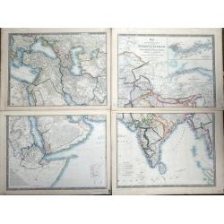
Map of the Countries lying between Turkey & Birmah, comprising Asia Minor, Persia, India, Egypt & Arabia, and including the Black, Caspian & Red seas by James Wyld, Geographer to the Queen, Charing Cross East. Model of the Earth, Leicester Square, London.
Map of the Countries lying between Turkey & Birmah, comprising Asia Minor, Persia, India, Egypt & Arabia, and including the Black, Caspian & Red seas by James...
Date: London, 1855
Selling price: ????
Please login to see price!
Sold in 2013
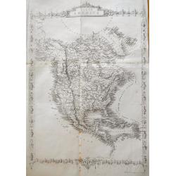
North America.
Very detailed and up-to-date map of North America, from Russian America (Alaska) to Panama, including the West Indies. With numerous place names and Indian tribes! This ...
Date: London, ca. 1855
Selling price: ????
Please login to see price!
Sold in 2013
China and Birmah.
Very detailed and up-to-date map, from the Bay of Bengal to Formosa (Taiwan). Includes also a part of Luzon. Filled with place names! This is the uncommon and slightly l...
Date: London, ca. 1855
Selling price: ????
Please login to see price!
Sold in 2013
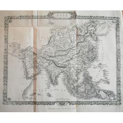
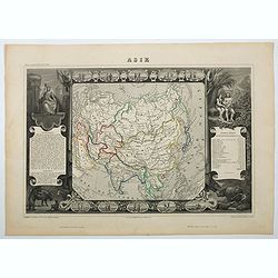
Asia.
Very detailed and up-to-date map, reaching from the Ural mountains until New Guinea. Locating tribes, mountains, rivers, cities,... This is the uncommon and slightly lat...
Date: London, c1855
Selling price: ????
Please login to see price!
Sold in 2013
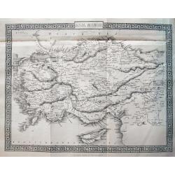
Asia Minor.
Very detailed and up-to-date map of Turkey including Cyprus. With numerous place names, roads connecting the towns, rivers, mountains, and regions. This is the uncommon ...
Date: London, c1855
Selling price: ????
Please login to see price!
Sold in 2013
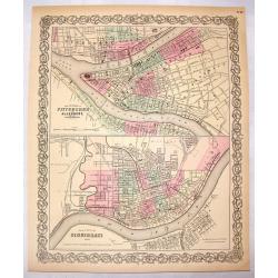
The Cities of Pittsburgh & Allegheny & The City of Cincinnati.
A hand-colored first edition of Colton's interesting two part map of Pittsburgh Pennsylvania and Cincinnati, Ohio. Interestingly, both maps are drawn to the same scale.
Date: New York, 1855
Selling price: ????
Please login to see price!
Sold in 2016
A Panoramic View of the Town, Harbour, Forts & Defences of Sebastopol & The Siege Works of The Allied Armies of England & France.
Printed & Published April 18th 1855 by Stannard & Dixon 7, Poland St London. A large panoramic plan of the town, harbour, forts and defenses of Sevastopol in Ukra...
Date: London, 1855
Selling price: ????
Please login to see price!
Sold in 2014