Browse Listings
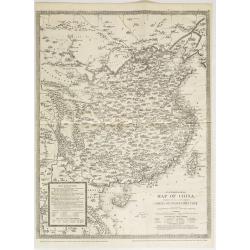
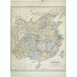
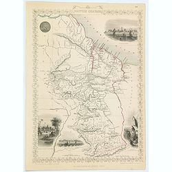
Panoramic map of China. Published with No.16, new series of Cassell's illustrated family paper.
Uncommon map of China and Taiwan with relief shown pictorially. Published with No. 16, new series, of Cassell's illustrated family paper. In an inset lower left "Use...
Date: London, John Cassel, March 20,1857
Selling price: ????
Please login to see price!
Sold in 2009
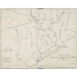
Tracé d'une partie du Chemin de Fer de Galveston à Houston et Henderson. Texas Etats Unis D'Amerique.
Hand colored map of the area between Galveston, Harrisburg, Richmond and Houston, showing "Galveston, Houston & Henderson railroad", also "Buffalo Bayo...
Date: Paris, ca. 1857
Selling price: ????
Please login to see price!
Sold in 2010
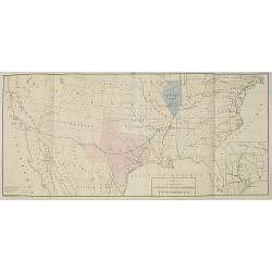
Carte du Chemin de Fer de Galveston Houston & Henderson. Texas Etats Unis D'Amerique.
Hand colored map of the United States showing the "Galveston, Houston & Henderson" railroad system. The state of Texas is colored in pink and Illinois in bl...
Date: Paris, Imp. Kaeppelin, 17 Quai Voltaire, ca 1857
Selling price: ????
Please login to see price!
Sold in 2010
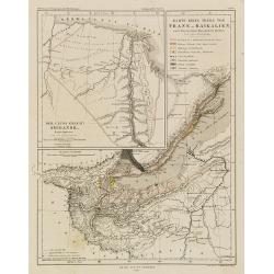
Der Uluss (Chant) Shigansk. Nach Chitrov. - Gez. von A. Petermann - Karte eines Theils von Trans-Baikalien nach den neuesten Russischen Quellen. Gez. von A. Petermann.
Detailed map centered on the Baikal Sea in Siberia, Russia. With inset map of the Lena River. From "Petermann's Geographische Mittheilungen".Lithographed by C.H...
Date: Justus Pertus, Gotha, 1857
Selling price: ????
Please login to see price!
Sold in 2010
![[untitled map of Japan]](/uploads/cache/99952-250x250.jpg)
[untitled map of Japan]
Superb 19th century woodblock printed map of Japan. Ansei 4 = 1857. Edo period. Also with parts of Korea (Chosen) and Hokkaido (Ezo). Shows the entire island, with much d...
Date: Japan, c1857
Selling price: ????
Please login to see price!
Sold in 2011

Private Signals of the Whaling Vessels Belonging to the Port of New Bedford.
Smaller (and maybe later?) edition of this important and rare publication, showing numerous flags of shipping companies, with the ships names. Lithograph with color, pub...
Date: New Bedford, c.1857
Selling price: ????
Please login to see price!
Sold in 2011
Carte de la Chine dressée d'après les matériaux Chinois les plus authentiques par J. Klaproth avec l'indication des cinq ports ouverts aux Européens. . .
Detailed map of China east of Tibet and including the islands of Tonkin and Taiwan. According to the title the map indicated the five ports open to the European traders a...
Date: Paris, Benjamin Dupart, 1857
Selling price: ????
Please login to see price!
Sold
London And Its Environs.
Folding map of London and the surrounding regions. The extents cover the area from Potters Bar down to Epsom and Gravesend across to Windsor. Uncolored except for the pri...
Date: Southampton, 1857
Selling price: ????
Please login to see price!
Sold in 2023
Chart showing the track of the Flagships of the US-Japan Expedition to the eastward of the Cape of Good Hope 1853 & 1854.
A simple sea chart showing the track of the US Steam Frigate Mississippi.
Date: New York, 1857
Selling price: ????
Please login to see price!
Sold in 2020
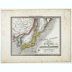
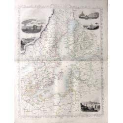
La Corea La Manciuria L' Impero del Giappone e le Isole Kurille.
Uncommon map of Korea, Japan and part of China, prepared by Francesco Costantino Marmocchi. Above the map "Geografia Commerciale". From "Il Globo Atlante d...
Date: Genova, Paolo Rivara fu Giacomo, 1858
Selling price: ????
Please login to see price!
Sold in 2022
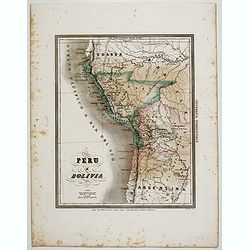
Peru e Bolivia.
Uncommon map of Peru and Bolivia prepared by Francesco Costantino Marmocchi. Above the map "Geografia Commerciale". From "Il Globo Atlante di carte Geograf...
Date: Genova, Paolo Rivara fu Giacomo, 1858
Selling price: ????
Please login to see price!
Sold in 2020
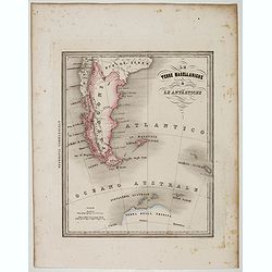
Le Terre Magellanighe e Le Antartiche.
Uncommon map of Patagonia and part of Antarctica, prepared by Francesco Costantino Marmocchi. Above the map "Geografia Commerciale". From "Il Globo Atlante...
Date: Genova, Paolo Rivara fu Giacomo, 1858
Selling price: ????
Please login to see price!
Sold in 2022
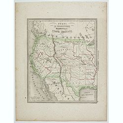
Stati e territorii Occidentali della Unione Americana.
Rare map of the Transmississippi West, with an oversized California, Oregon, Nebraska, Kansas, New Mexico and Utah and a totally eclipsing Washington, Idaho, North & ...
Date: Genova, Paolo Rivara fu Giacomo, 1858
Selling price: ????
Please login to see price!
Sold in 2020
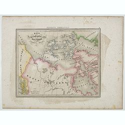
Mari e Arcipelaghi Polari Artici dalla Baia d'Hudson all' America Russa.
Uncommon map of Canada prepared by Francesco Costantino Marmocchi. Above the map "Geografia Commerciale". From "Il Globo Atlante di carte Geografiche compi...
Date: Genova, Paolo Rivara fu Giacomo, 1858
Selling price: ????
Please login to see price!
Sold in 2020
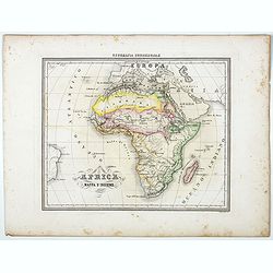
Africa Mappa d'Insieme.
Uncommon map of the African continent prepared by Francesco Costantino Marmocchi. Above the map "Geografia Commerciale". From "Il Globo Atlante di carte Ge...
Date: Genova, Paolo Rivara fu Giacomo, 1858
Selling price: ????
Please login to see price!
Sold in 2021
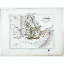
La Nubia E l'Abissinia . . .
Uncommon map of East coast of Africa with Sudan, Nubia and lower Nile, prepared by Francesco Costantino Marmocchi. Above the map "Geografia Commerciale". From &...
Date: Genova, Paolo Rivara fu Giacomo, 1858
Selling price: ????
Please login to see price!
Sold in 2021
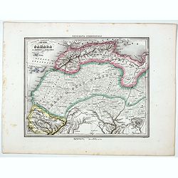
Il Gran Deserto di Sahara . . .
Uncommon map of the Sahara Dessert, Senegal, Morocco and Tunisia, prepared by Francesco Costantino Marmocchi. Above the map "Geografia Commerciale". From "...
Date: Genova, Paolo Rivara fu Giacomo, 1858
Selling price: ????
Please login to see price!
Sold in 2020
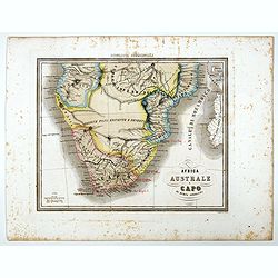
Africa Australe E Capo di buona Speranza.
Uncommon map of Southern Africa and islands prepared by Francesco Costantino Marmocchi. Above the map "Geografia Commerciale". From "Il Globo Atlante di ca...
Date: Genova, Paolo Rivara fu Giacomo, 1858
Selling price: ????
Please login to see price!
Sold in 2021
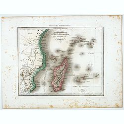
Madagascar e le Isole E le Coste Circonvicine Dell' Africa nel Mar Delle Indie.
Uncommon map of Madagascar, Seychelles, La Réunion and Mauritius and East Coast of Africa around Mozambique, prepared by Francesco Costantino Marmocchi. Above the map &q...
Date: Genova, Paolo Rivara fu Giacomo, 1858
Selling price: ????
Please login to see price!
Sold in 2022
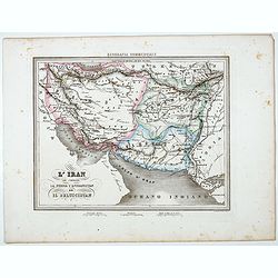
L'Iran che comprende La Persia l'Afghanistan ed Il Beluscistan.
Uncommon map of Greater Iran, showing the regions of the Caucasus, West Asia, Central Asia, and South Asia, prepared by Francesco Costantino Marmocchi. Above the map &quo...
Date: Genova, Paolo Rivara fu Giacomo, 1858
Selling price: ????
Please login to see price!
Sold in 2022

Le Isole della sonda Borneo, Sumatra, Giava Celebes e Le Molucche.
Uncommon map of Southeast Asia including Singapore, much of Indonesia, Bali, Timor, Borneo, the island of Mindanao in the Philippines, and the northern coast of Australia...
Date: Genova, Paolo Rivara fu Giacomo, 1858
Selling price: ????
Please login to see price!
Sold in 2021
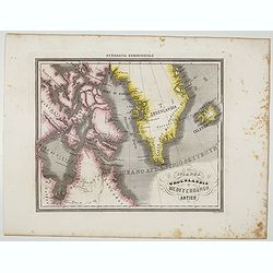
Islanda Groenlandia e Mediterraneo Artico.
Uncommon map of Canada, Greenland and Iceland prepared by Francesco Costantino Marmocchi. Above the map "Geografia Commerciale". From "Il Globo Atlante di ...
Date: Genova, Paolo Rivara fu Giacomo, 1858
Selling price: ????
Please login to see price!
Sold in 2021
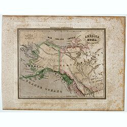
America Russa.
Uncommon map of Alaska prepared by Francesco Costantino Marmocchi. Above the map "Geografia Commerciale". From "Il Globo Atlante di carte Geografiche compi...
Date: Genova, Paolo Rivara fu Giacomo, 1858
Selling price: ????
Please login to see price!
Sold in 2020
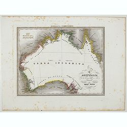
L'Australia con la divisione delle sue coste proposta dal Capit° Vetch.
Uncommon map of Australia after James Vetch, a military engineer by training, Vetch was commissioned into the Royal Engineers and served with distinction in the Peninsula...
Date: Genova, Paolo Rivara fu Giacomo, 1858
Selling price: ????
Please login to see price!
Sold in 2020
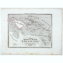
La Melanesia ossla Le Isole de Meri Oceanici . . .
Uncommon map of New Guinea, Solomon Islands prepared by Francesco Costantino Marmocchi. Above the map "Geografia Commerciale". From "Il Globo Atlante di ca...
Date: Genova, Paolo Rivara fu Giacomo, 1858
Selling price: ????
Please login to see price!
Sold in 2021
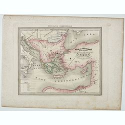
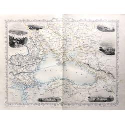
Bacino del Mediterraneo ( Parte orientale) . . .
Uncommon map with the Mediterranean Sea, centered on Greece. With a key to tracks of different streamline routes, prepared by Francesco Costantino Marmocchi. Above the ma...
Date: Genova, Paolo Rivara fu Giacomo, 1858
Selling price: ????
Please login to see price!
Sold in 2021
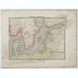
Mar Batilco sur isole e Paesi Circonstanti . . .
Uncommon map of Baltic Sea prepared by Francesco Costantino Marmocchi. Above the map "Geografia Commerciale". From "Il Globo Atlante di carte Geografiche c...
Date: Genova, Paolo Rivara fu Giacomo, 1858
Selling price: ????
Please login to see price!
Sold in 2020

Egitto.
Uncommon map of Egypt prepared by Francesco Costantino Marmocchi. Above the map "Geografia Commerciale". From "Il Globo Atlante di carte Geografiche compil...
Date: Genova, Paolo Rivara fu Giacomo, 1858
Selling price: ????
Please login to see price!
Sold in 2021
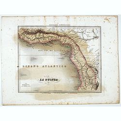
La Guinea.
Uncommon map of Guinea prepared by Francesco Costantino Marmocchi. Above the map "Geografia Commerciale". From "Il Globo Atlante di carte Geografiche compi...
Date: Genova, Paolo Rivara fu Giacomo, 1858
Selling price: ????
Please login to see price!
Sold in 2021
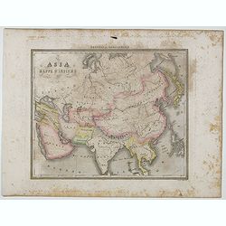
Asia Mappa d'Insieme.
Uncommon map of Asia prepared by Francesco Costantino Marmocchi. Above the map "Geografia Commerciale". From "Il Globo Atlante di carte Geografiche compila...
Date: Genova, Paolo Rivara fu Giacomo, 1858
Selling price: ????
Please login to see price!
Sold in 2020
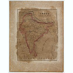
L'India e L'Isola di Seilan.
Uncommon map of India prepared by Francesco Costantino Marmocchi. Above the map "Geografia Commerciale". From "Il Globo Atlante di carte Geografiche compil...
Date: Genova, Paolo Rivara fu Giacomo, 1858
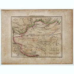
Asia Centrale ( Tibet, Thian-Scian-Nan-Lu, Mongolia, Gran Deserto, &)
Uncommon map of Tibet prepared by Francesco Costantino Marmocchi. Above the map "Geografia Commerciale". From "Il Globo Atlante di carte Geografiche compil...
Date: Genova, Paolo Rivara fu Giacomo, 1858
Selling price: ????
Please login to see price!
Sold in 2020
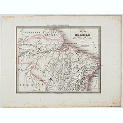
Impero del Brasile Parte Nord.
Uncommon map of Brazil northside prepared by Francesco Costantino Marmocchi. Above the map "Geografia Commerciale". From "Il Globo Atlante di carte Geograf...
Date: Genova, Paolo Rivara fu Giacomo, 1858
Selling price: ????
Please login to see price!
Sold in 2022
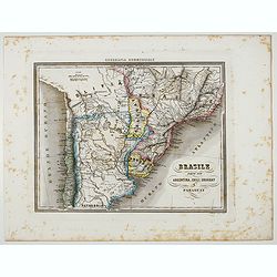
Brasile Parte Sud Argentina, Chili, Uruguay e Paraguay.
Uncommon map of Brasile Southside, Argentina, Chili, Uruguay and Paraguay. northside prepared by Francesco Costantino Marmocchi. Above the map "Geografia Commerciale...
Date: Genova, Paolo Rivara fu Giacomo, 1858
Selling price: ????
Please login to see price!
Sold in 2022

Le Vie Ferrate e le Postali della Francia Meridionale . . .
Uncommon map of South of France and part of Spain prepared by Francesco Costantino Marmocchi. Above the map "Geografia Commerciale". From "Il Globo Atlante...
Date: Genova, Paolo Rivara fu Giacomo, 1858
Selling price: ????
Please login to see price!
Sold in 2020
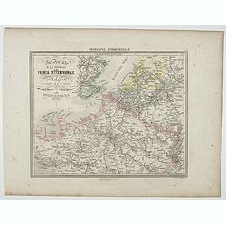
Le Vie Ferrate e le Postali della Francia Settentrionale . . .
Uncommon map of North of France and part of Belgium and England prepared by Francesco Costantino Marmocchi. Above the map "Geografia Commerciale". From "Il...
Date: Genova, Paolo Rivara fu Giacomo, 1858
Selling price: ????
Please login to see price!
Sold in 2020
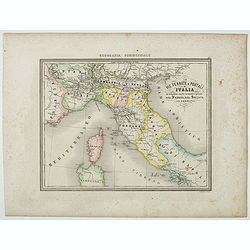
Le Vie Ferrate e Postali d'Italia . . .
Uncommon map of central Italy and part of Switzerland and France prepared by Francesco Costantino Marmocchi. Above the map "Geografia Commerciale". From "I...
Date: Genova, Paolo Rivara fu Giacomo, 1858
Selling price: ????
Please login to see price!
Sold in 2023
Coast of Syera Lykanderin Latakiah & marshal. 1858
Map showing the Gulf of İskenderun, at the foot of the Nur Mountains (Amanos Mountains).. The town of İskenderun in lower right. The map is dated 1858 ...
Date: ca. 1858
Selling price: ????
Please login to see price!
Sold in 2020
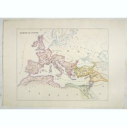
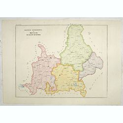
Patriarcati Antichi (Tav II)
This large-format Europe map is finely engraved and beautifully colored and was prepared by Girolamo Petri, a lawyer who served as a senior official within the Vatican’...
Date: Rome, 1858
Selling price: ????
Please login to see price!
Sold in 2020
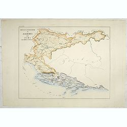
Province ecclesiastiche di Zagrabia e di Zara nell' Impero Austriaco (Tav LXXIII)
This large-format Zagrabia and Zara map is finely engraved and beautifully colored and was prepared by Girolamo Petri, a lawyer who served as a senior official within the...
Date: Rome, 1858
Selling price: ????
Please login to see price!
Sold in 2020
Provincie ecclesiastiche di Leopoli e Fogaras ed Altre Diocesi di Rito Greco (Tav LXXV)
This large-format Romania map is finely engraved and beautifully colored and was prepared by Girolamo Petri, a lawyer who served as a senior official within the Vatican�...
Date: Rome, 1858
Selling price: ????
Please login to see price!
Sold in 2025

Circoscrizione delle province ecclesiastiche Diocesi e missioni nella Germania (Tav LXXVI)
This large-format Germany map is finely engraved and beautifully colored and was prepared by Girolamo Petri, a lawyer who served as a senior official within the Vatican�...
Date: Rome, 1858
Selling price: ????
Please login to see price!
Sold in 2021
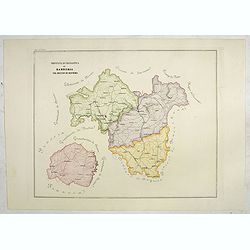
Province ecclesiastica di Monaco nel regno di Baviera (Tav LXXVII)
This large area of southern Germany, centered on Regensburg and western Austria, with the tip of Lake Constance to the left.The map is finely engraved and beautifully col...
Date: Rome, 1858
Selling price: ????
Please login to see price!
Sold in 2021
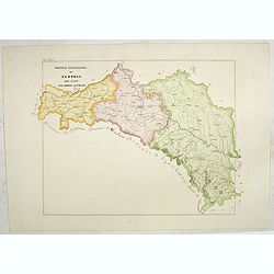
Provincia ecclesiastica di Bamberga nel regno di Baviera (Tav LXXVIII)
This large-format Bamberg map is finely engraved and beautifully colored and was prepared by Girolamo Petri, a lawyer who served as a senior official within the Vatican�...
Date: Rome, 1858
Selling price: ????
Please login to see price!
Sold in 2020
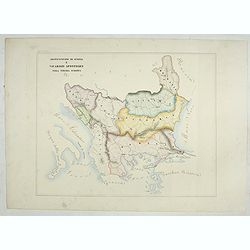
Provincia ecclesiastica di Leopoli rito latino nell' Impero Austriaco (Tav LXXIV)
This large-format south Poland map is finely engraved and beautifully colored and was prepared by Girolamo Petri, a lawyer who served as a senior official within the Vati...
Date: Rome, 1858
Selling price: ????
Please login to see price!
Sold in 2021
Arcivescovato di Scopia e vicariati Apostolici nella Turchia Europea. (Tav XCVIII)
This large-format map of Eastern Europe, including Bosnia, Herzegovina, Albania, Montenegro, Servia, Bulgaria, Romania and Molavia. The map is finely engraved and beautif...
Date: Rome, 1858
Selling price: ????
Please login to see price!
Sold in 2025
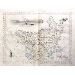
British Guayana.
A decorative steel engraved map of British Guyana. The last Tallis map of the region, published circa 1858 by The London Printing and Publishing Company (the partnership ...
Date: London, 1858
Selling price: ????
Please login to see price!
Sold in 2020
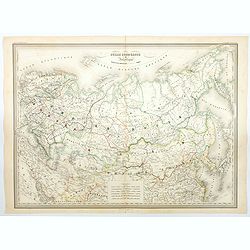
Russie Europeenne et Asiatique.
A large detailed map of the entirety of the Russian Empire, as it was under Czar Alexander II in the middle of the nineteenth century. Also shown as part of the map are F...
Date: Paris, 1858
Selling price: ????
Please login to see price!
Sold in 2020
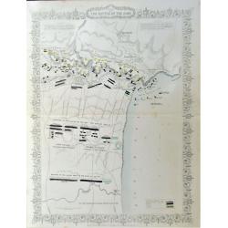
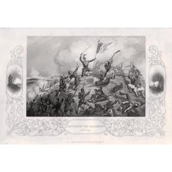
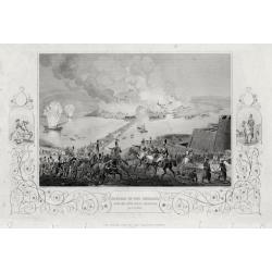
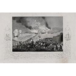
Plan of the Battle of the Alma.
A detailed steel engraved map of the Battle of Alma The map includes a hand colored key as to the positions of the English, French, Turks, and Russians. Inscription: Draw...
Date: London, 1858
Selling price: ????
Please login to see price!
Sold in 2020
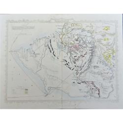
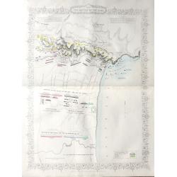
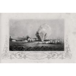
Siege of Sebastopol.
A detailed steel engraved map of Sebastopol. The map includes a hand colored key as to the positions of the English, French, Turks, Russians, and Sardinians. Dates and po...
Date: London, 1858
Selling price: ????
Please login to see price!
Sold in 2020
(Crimea) A complete set of 26 engravings depicting The Crimea war, the Battles between the Russian Empire ...
A complete set of 26 engravings depicting The Crimea war, the Battles between the Russian Empire and several European powers for influence over territories of the declini...
Date: London, 1858
Selling price: ????
Please login to see price!
Sold in 2015

Japan.
The Empire of Japan with part of the continent of Asia and the New Boundary between the Russian and Chinese borders. From the Weekly Dispatch Atlas.
Date: London, 1858
Selling price: ????
Please login to see price!
Sold in 2013
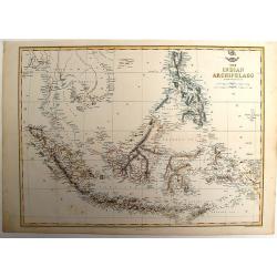
The Indian Archipelago.
A detailed map of the Indian Archipelago including The Philippines, Sumatra, Java and most of Papua & New Guinea. Has a small cartouche "The Dispatch Atlas"...
Date: London, 1858
Selling price: ????
Please login to see price!
Sold in 2013
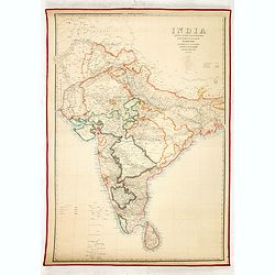
India shewing the post roads and dawk stationsby James Wyld, geographer to the Queen and H.R.H. Prince Albert.
Decorative post road map also showing railways. A color key is showing British possessions, subsidiary states, and protected and independent areas. Scale [ca. 1:4,400,000...
Date: London, ca. 1858
Selling price: ????
Please login to see price!
Sold in 2016
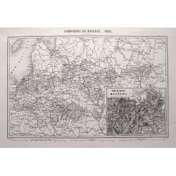
CAMPAGNE DE RUSSIE 1812.
Highly detailed map showing the area from Poland and the Baltics to Moscow, including the cities of Kiev, Minsk, Smolensk, Riga, and many more. An inset map shows the are...
Date: Paris, 1858
Selling price: ????
Please login to see price!
Sold in 2015

A complete set of 30 engravings depicting The Crimea war, the Battles between the Russian Empire and several European powers for influence over territories of the declining Ottoman Empire, Nicholas I. Emperor of Russia and the Military Leaders of the Euro
A complete set of 28 engravings depicting The Crimea war, the Battles between the Russian Empire and several European powers for influence over territories of the declini...
Date: London, 1858
Selling price: ????
Please login to see price!
Sold in 2016
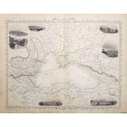
Black Sea.
A highly detailed and decorative map with six vignette illustrations. One of the John Tallis maps published around the time of the Crimea War by The London Printing and P...
Date: London, 1858
Selling price: ????
Please login to see price!
Sold in 2016
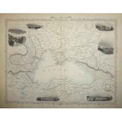
Black Sea
A highly detailed and decorative map of the Black Sea and surrounding areas. The map is enhanced by vignette illustrations of Sebastopol, Varna, Odessa, Sinope, Silistra...
Date: London, 1858
Selling price: ????
Please login to see price!
Sold in 2017
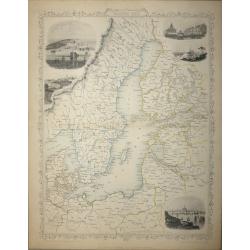
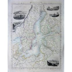
Baltic Sea - John Tallis
A highly detailed and decorative map of the Baltic Sea and surrounding countries with five vignette illustrations.One of the John Tallis maps published around the time of...
Date: London, 1858
Selling price: ????
Please login to see price!
Sold in 2015
(Crimea) A set of 24 engravings depicting The Crimea war, the Battles between the Russian Empire and several European powers for influence over territories of the declining Ottoman Empire.
A set of 24 engravings depicting The Crimea war, the Battles between the Russian Empire and several European powers for influence over territories of the declining Ottoma...
Date: London, 1858
Selling price: ????
Please login to see price!
Sold in 2015
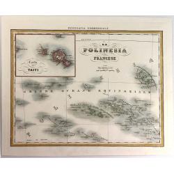
La Polinesia Francese.
A pleasant map featuring the Polynesian Islands, with an insert of Tahiti (Carta di Taiti). It is from the atlas "Geografia Commerciale", engraved by G. Bonatti...
Date: Torino, 1858
Selling price: ????
Please login to see price!
Sold in 2016
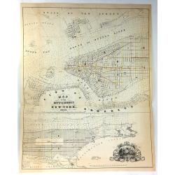
Map of the City & County of New York.
Detailed lithograph plan in two joined parts. The upper map details lower Manhattan up to 39th Street, and the lower map continuing the chart up to King's Bridge. There a...
Date: New York, 1858
Selling price: ????
Please login to see price!
Sold in 2017
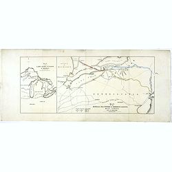
Map of lakes Huron, superior & Michigan, on a smaller scale. / Map of the Buffalo, Brantford & Goderich railway west Canada with its connections
Two maps on one sheets. First map of "Map of lakes Huron, superior & Michigan, on a smaller scale." measuring 227 x 150mm. The map to the right "Map of...
Date: London, after 1858
Selling price: ????
Please login to see price!
Sold in 2020
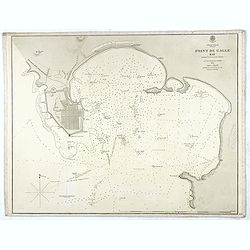
Indian Ocean Ceylon - Point de Galle Bay.
Showing the bay of Galle, surveyed by Mr TH Twynham Master Attendent at Pt de Galle. Also with surveys by Sir. Edward Belcher, and Alexander Dalrymple, first hydrographer...
Date: London, 1858
Selling price: ????
Please login to see price!
Sold
A set of 18 engravings ‘The Crimea War' the Battles between the Russian Empire and the European powers for influence over territories of the declining Ottoman Empire, Nicholas I. Emperor of Russia and the Military Leaders of the European powers.
A collection of 18 steel engravings, depicting The Crimea war, those Battles between the Russian Empire and several European powers for influence over territories of the ...
Date: London, 1858
Selling price: ????
Please login to see price!
Sold in 2016
Baltic Sea - John Tallis
A highly detailed and decorative map of the Baltic Sea and surrounding countries with five vignette illustrations.One of the John Tallis maps published around the time of...
Date: London, 1858
Selling price: ????
Please login to see price!
Sold in 2016
Plan of The Battle of The Alma
A highly detailed battle plan depicting the 'Battle of the Alma River in Crimea', one of the first battles of the Crimean War.The Battle of the Alma was fought September ...
Date: London, 1858
Selling price: ????
Please login to see price!
Sold in 2016
Black Sea
A map of the Black Sea and the surrounding lands, including Turkey, Russia, Georgia, Azerbaijan, Bulgaria, Crimea and Armenia, with six decorative vignettes views of Seba...
Date: London, 1858
Selling price: ????
Please login to see price!
Sold in 2018
'Turkey in Europe'
A highly decorative and detailed mid-19th century map of 'Turkey in Europe' The Balkans: northern Greece, Macedonia, Bulgaria, Albania, Serbia, Bosnia-Herzogovina, southe...
Date: London, 1858
Selling price: ????
Please login to see price!
Sold in 2016
‘The Crimea War' 18 engravings depicting the Battles between the Russian Empire and the European powers for influence over territories of the declining Ottoman Empire, and the Military Leaders of the European powers.
‘The Crimea War.’ 18 engravings depicting the Battles between the Russian Empire and the European powers for influence over territories of the declining Ottoman Empir...
Date: London, 1858
Selling price: ????
Please login to see price!
Sold in 2016
Baltic Sea
A highly detailed and decorative map of the Baltic Sea and surrounding countries with five vignette illustrations.One of the John Tallis maps published around the time of...
Date: London, 1858
Selling price: ????
Please login to see price!
Sold in 2016
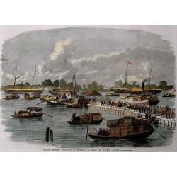
Sick and wounded embarking at Hong-Kong on Board the Steamer.
Large view of the harbour with numerous ships and people. From the Illustrated London News, October 23, 1858.
Date: London, 1858
Selling price: ????
Please login to see price!
Sold in 2016
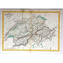
Carte de la Suisse, or Helvetie, par Delamarche, 1858.
Unusual map of Switzerland that has been boldly engraved to feature the remarkable mountainous topography of Switzerland. Charles-François Delamarche (1740 - 1817) was a...
Date: Paris , 1858
Selling price: ????
Please login to see price!
Sold in 2017
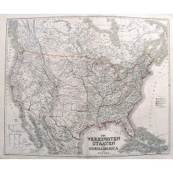
Die Vereinigten Staaten von Nord America nebst Canada.
A fascinating map of the United States, also parts of Canada and Mexico. Names several Territories and also Indian Territory. One of the most detailed maps of its time.
Date: Weimar, 1858
Selling price: ????
Please login to see price!
Sold in 2017
20 engravings depicting The Crimea war, the Battles between the Russian Empire and several European powers for influence over territories of the declining Ottoman Empire, Nicholas I. Emperor of Russia and Military Leaders of the European Powers.
An interesting set of 20 engravings depicting The Crimea war, the Battles between the Russian Empire and several European powers for influence over territories of the dec...
Date: London, 1858
Selling price: ????
Please login to see price!
Sold in 2017
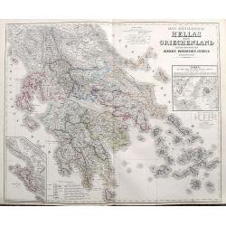
Das Königreich Hellas oder Griechenland und die Republik der sieben Ionischen Inseln (Ephtánisos).
Large and highly detailed map extending from Corfu to Santorini. With Peloponnese, Euboia, Mykonos, Kythira, Zakynthos, and many others. Includes two inset maps of Athens...
Date: Weimar, 1858
Selling price: ????
Please login to see price!
Sold in 2017
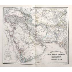
Vorder-Asien oder Iran, Turan, Arabien, Kleinasien und die Kaukasus Länder.
A great map filled with details including travel routes, and interesting borders and names. Centered on Iran it shows the area from Turkey to Mumbai in India. Includes Ar...
Date: Weimar, 1858
Selling price: ????
Please login to see price!
Sold in 2017
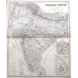
Vorder Indien.
An excellent map of India with nice coloring indicating colonial occupations. With two insets of upper Assam, and Ceylon.
Date: Weimar, 1858
Selling price: ????
Please login to see price!
Sold in 2017
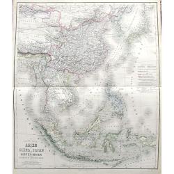
Das südöstliche Asien oder China, Japan, und Hinter-Indien mit dem Indischen Archipelagus.
Superb map from Mongolia until Timor. Includes Korea, Japan, China, the Philippines, Thailand, Singapore, Indonesia, etc. Richly detailed filled with place names. The col...
Date: Weimar, 1858
Selling price: ????
Please login to see price!
Sold in 2017
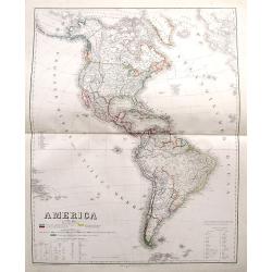
America.
A large map of the Americas with remarkable detail. Includes many early Territories shortly before statehood such as Utah, Oregon, Washington, Nebraska, etc. Shows Americ...
Date: Weimar, 1858
Selling price: ????
Please login to see price!
Sold in 2017