Browse Listings
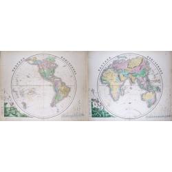
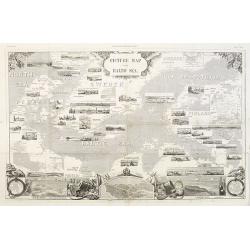
(Pair of 2 maps): Western Hemisphere & Eastern Hemisphere
Impressive size maps of the hemispheres, with comparisons of mountain hights and river lengths. Filled with place names and many interesting geographical features: -larg...
Date: Edinburgh, c1855
Selling price: ????
Please login to see price!
Sold in 2014
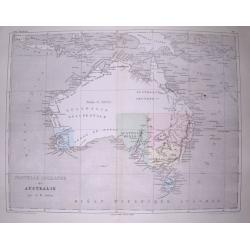
Nouvelle Hollande ou Australie.
Very interesting and detailed map of Australia, with the border of "Australie heureuse" along the Lachlan River. With numerous bays, rivers, hills, islands, etc...
Date: Paris, c1855
Selling price: ????
Please login to see price!
Sold in 2014
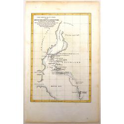
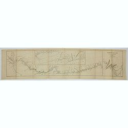
Chart Exhibiting the Discoveries of the Second American Grinnell Exhibition in Search of Sir John Franklin.
The expedition searching for Sir Franklin resulted in important advances in the exploration of Greenland and other previously unexplored Arctic regions.
Date: New York, 1855
Selling price: ????
Please login to see price!
Sold in 2016
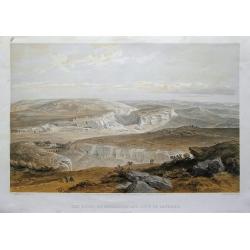
The ruins of Inkermann and city of caverns.
A spectacular view of the area of Inkerman in the Ukraine, now under Russian control (Crimean peninsula). Original colored lithograph by Day & Son. Published May 22nd...
Date: London, 1855
Selling price: ????
Please login to see price!
Sold in 2015
Chart of the Coast of China and of the Japan Islands including the Marianes and a Part of the Philippines.
Commodore Perry’s Sailing Directions for China and Japan with large map of Asian waters including the Mariana Islands and a part of the Philippines. Compiled by order o...
Date: Washington, 1855
Selling price: ????
Please login to see price!
Sold in 2015
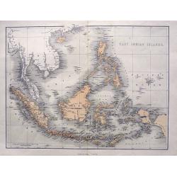
East Indian Islands.
Superb map of Indonesia, filled with many place names. Shows the area from Birma and Thailand to Papua New Guinea, including the Philippines, Singapore, Malaysia, Borneo,...
Date: London, ca. 1855
Selling price: ????
Please login to see price!
Sold in 2015
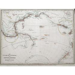
Der Vulkan-Gürtel und die Central-Gruppen des grossen Oceans.
Map shows the volcano's around the Pacific Ocean, China, Indonesia, Hawaii, and the Americas. Active volcano's are underlined in orange. Two circled areas show the main g...
Date: Hildburghausen, ca. 1855
Selling price: ????
Please login to see price!
Sold in 2015
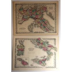
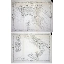
Northern Italy & Southern Italy (Two Maps)
A matched pair of maps that cover all of Italy. These beautifully engraved, hand-colored maps were published in Colton's monumental world atlas “Illustrated Atlas of th...
Date: New York, 1855
Selling price: ????
Please login to see price!
Sold in 2017

Colton's China
A map of China, Korea, Taiwan, Hong Kong and Macao. Surrounded by Colton's typical spiral motif border. From Colton's "ALAS OF THE WORLD".Joseph Hutchins Colton...
Date: New York, 1855
Selling price: ????
Please login to see price!
Sold in 2016
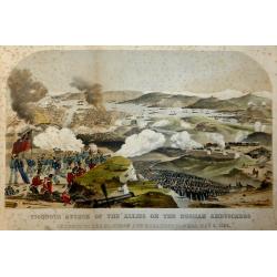
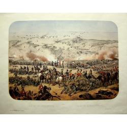
Vigorous Attack of the Allies on the Russian Ambuscades In front of the Mamelon and Malakoff Towers, May 9, 1855.
A highly detailed lithograph showing the battle to silence the Malakoff Towers. In the distance a view of Sebastopol looking towards the Dockyard Harbour... The Malakoff ...
Date: London, 1855
Selling price: ????
Please login to see price!
Sold in 2017
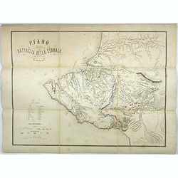
Plano della battaglia della Cernaia.
Large lithographed map showing the Battle of the Chernaya. Decorative title with numbered key (1-17) and a color key indicating the French, English, Italian, Turkish and ...
Date: Milan, 1855
Selling price: ????
Please login to see price!
Sold in 2017
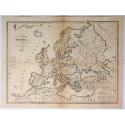
Carte Generale dell Europa Divisa ne Suoi Principali Stati.
A pleasing map of Europe by Cassella, published in Turin in 1855.
Date: Turin, 1855
Selling price: ????
Please login to see price!
Sold in 2017
Creta Insula sec. Stadiasmum Maris Magni.
Delicate map of ancient Crete, according to the "Stadiasmus Maris Magni", prepared by Karl Wilhelm Ludwig Muller (1813-1894) and published in "Geographi Gr...
Date: Paris, Ambrosio Firmin Didot, 1855
Selling price: ????
Please login to see price!
Sold in 2017
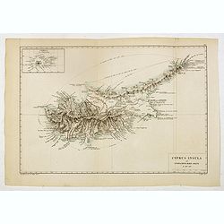
Cyprus Insula ad Stadiasmum Maris Magni S. 297-317
Delicate map of ancient Crete according to the "Stadiasmus Maris Magni", prepared by Karl Wilhelm Ludwig Muller (1813-1894) and published in "Geographi Gra...
Date: Paris, Ambrosio Firmin Didot, 1855
Selling price: ????
Please login to see price!
Sold in 2017
Scylacis Periplus. . .
Delicate map of ancient Greece and the West coast of Turkey according to the "Stadiasmus Maris Magni", prepared by Karl Wilhelm Ludwig Muller (1813-1894) and pu...
Date: Paris, Ambrosio Firmin Didot, 1855
Selling price: ????
Please login to see price!
Sold in 2017
Sinus Arabici pars borealis secundum Agatharchidem, Artimidorum, Plinium, Ptolemaeum. (Northern part of the Red Red Sea)
Seven maps on one sheet showing the Northern part of the Red Sea according to the "Stadiasmus Maris Magni", prepared by Karl Wilhelm Ludwig Muller (1813-1894) a...
Date: Paris, Ambrosio Firmin Didot, 1855
Selling price: ????
Please login to see price!
Sold in 2020
Sinus Arabici pars meridionalis secundum Agatharchidem, Artimidorum, Plinium, Ptolemaeum. (Southern part of the Red Red Sea)
Eight maps on one sheet showing the Southern part of the Red Sea according to the "Stadiasmus Maris Magni", prepared by Karl Wilhelm Ludwig Muller (1813-1894) a...
Date: Paris, Ambrosio Firmin Didot, 1855
Selling price: ????
Please login to see price!
Sold in 2020
Sinus Arabici pars media secundum Agatharchidem, Artimidorum, Plinium, Ptolemaeum. (Center part of the Red Red Sea)
Nine maps on one sheet showing the center part of the Red Sea according to the "Stadiasmus Maris Magni", and prepared by Karl Wilhelm Ludwig Muller (1813-1894) ...
Date: Paris, Ambrosio Firmin Didot, 1855
Selling price: ????
Please login to see price!
Sold in 2020
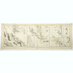
Ora regionis aromatiferae a ras gulvainy adbasHafoun. / Libye oraorientalissecundum Periplum maris Erythraei. (The United Arab Emirates)
Four maps on one sheet. The right hand map showing The United Arab Emirates, the other maps the larger region including Oman. These ancient maps are according to the &quo...
Date: Paris, Ambrosio Firmin Didot, 1855
Selling price: ????
Please login to see price!
Sold in 2020
Arabiae Ora australis secundum Periplum maris Erythraei. (Oman)
Three maps on one sheet. The larger map showing Oman, the other maps the larger region including Oman. These ancient maps are according to the "Stadiasmus Maris Magn...
Date: Paris, Ambrosio Firmin Didot, 1855
Selling price: ????
Please login to see price!
Sold in 2020
Dachinabadae ora Maritima secundum anonymi periplum maris erythrei. (India)
Two ancient maps on one sheet showing India, prepared by Karl Wilhelm Ludwig Muller (1813-1894) and published in "Geographi Graeci Minores". Muller wrote in Lat...
Date: Paris, Ambrosio Firmin Didot, 1855
Selling price: ????
Please login to see price!
Sold in 2017
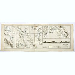
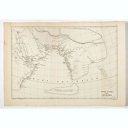
Nearchi Navigatio ab indo ad Euphratem secundum arriani historiam Indicum. . .
Three maps showing the coastline of Iran and Pakistan according to the "Stadiasmus Maris Magni", and prepared by Karl Wilhelm Ludwig Muller (1813-1894) and publ...
Date: Paris, Ambrosio Firmin Didot, 1855
Selling price: ????
Please login to see price!
Sold in 2019
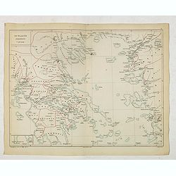
Ponti Euxini Periplus secundum Arrianum.
Two ancient maps on one sheet showing the Black Sea and Ukraine, prepared by Karl Wilhelm Ludwig Muller (1813-1894) and published in "Geographi Graeci Minores"....
Date: Paris, Ambrosio Firmin Didot, 1855
Selling price: ????
Please login to see price!
Sold in 2017
Anonymi auctoris periplus Maris Erythraei.
Delicate map showing the Indian Ocean during ancient times according to the "Stadiasmus Maris Magni", and prepared by Karl Wilhelm Ludwig Muller (1813-1894) and...
Date: Paris, Ambrosio Firmin Didot, 1855
Selling price: ????
Please login to see price!
Sold in 2017
Russia in Europe showing the Territorial Acquisitions since the time of Peter the Great.
"Russia in Europe showing the Territorial Acquisitions since the time of Peter the Great" This map shows the acquisitions from Turkey, Sweden, Poland and Persia...
Date: London, 1855
Selling price: ????
Please login to see price!
Sold in 2019
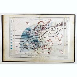
Atlas de physique et de meteorologie agricoles.
Rare atlas of meteorology and agronomy of France, Europe and the world printed by Hayet in Versailles. Illustrated with frontispiece and 13 maps lithographed in colors. T...
Date: Paris, Bachelier / Versailles, Hayet, 1855
Selling price: ????
Please login to see price!
Sold in 2019
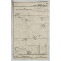
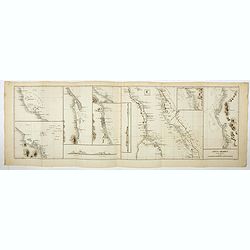
A Chart of the Cape Verde Islands, Drawn from the Latest Authorities by J.W. Norie, Hydrogrpher.
An original and striking, mariners chart of the Cape Verde Islands in the Atlantic Ocean, off the coast of Africa. It is by J. W. Norie one of the most important chart ma...
Date: London, 1855
Selling price: ????
Please login to see price!
Sold in 2018
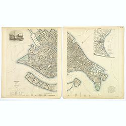
Venice.
A lovely steel engraved plan, on 2 sheets, of Venice by the Society for the Diffusion of Useful Knowledge (SDUK). This English philanthropic enterprise was entirely devot...
Date: London, 1855
Selling price: ????
Please login to see price!
Sold in 2018
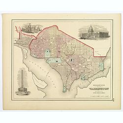
Georgetown and the City of Washington, the Capital of the United States of America.
An excellent 1855 example of Colton's plan of Washington D.C. and Georgetown. It covers the city in detail from Georgetown (Georgetown University, then College, shown) in...
Date: New York, 1855
Selling price: ????
Please login to see price!
Sold in 2018
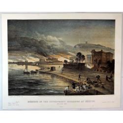
Burning of the Government buildings at Kertch.
A fine hand colored lithograph from "THE SEAT OF WAR IN THE EAST". By the illustrator William Simpson (1823-1899). Published in London in 1855 by Paul and Domin...
Date: London, 1855
Selling price: ????
Please login to see price!
Sold in 2018
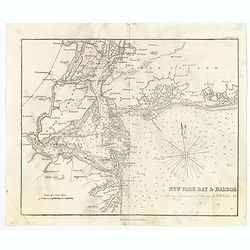
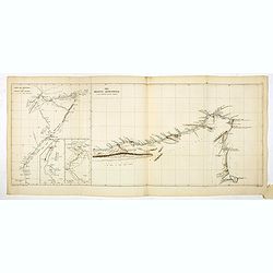
New York Bay & Harbor. . .
The chart provides a fantastically detailed look at the Harbor of New York and environs. The chart includes detailed depth soundings, and has a directional rose.The chart...
Date: London, ca 1855
Selling price: ????
Please login to see price!
Sold in 2018
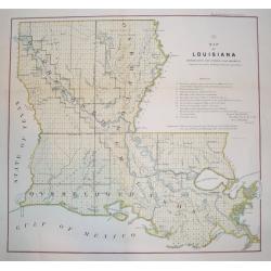
Map of Louisiana Representing the Several Land Districts
A handsome and very uncommon map of Louisiana. The work is a detailed survey of the State's various land divisions. A 12 point reference table provides letter coding and ...
Date: Donoldsonville, Louisiana, dated 1855
Selling price: ????
Please login to see price!
Sold
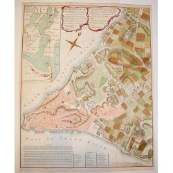
A Plan of the City of New York & its Environs to Greenwich.
A marvelous re-issue of Major John Montresor's famous and exceedingly scarce official plan of New York. This plan was specially commissioned by George Hayward in 1854 fo...
Date: New York, 1855
Selling price: ????
Please login to see price!
Sold
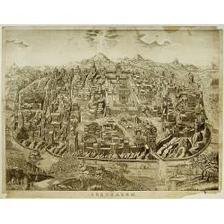
Jerusalem.
Very rare bird's eye view of the Holy City of Jerusalem. Engraved in stone by C.Bruder.The town plan is very detailed and has 159 numbers referring to the most important ...
Date: Germany, c. 1855
Selling price: ????
Please login to see price!
Sold
Grand atlas Universel physique, historique et politique geographie ancienne et moderne.
Atlas with 40 maps of the old and modern world, prepared by CH. Dyonnet . Each map measures about 55x74cm.
Date: Paris 1855
Selling price: ????
Please login to see price!
Sold

New Jersey.
From: System of Geography for the use of schools , published by Harper and brothers, 329 Pearl Street, New York.Page 37/38 from Sidney E. Morse's: System of Geography for...
Date: New York, 1855
Selling price: ????
Please login to see price!
Sold in 2015
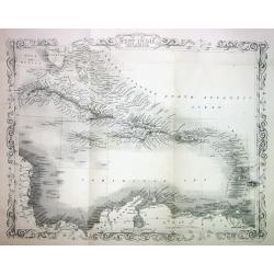
West India Islands.
This is the uncommon and slightly later edition by Rapkin based on Tallis' maps. The vignettes have been removed and the map is issued in black and white. The map extends...
Date: London 1855
Selling price: ????
Please login to see price!
Sold
Etats-Unis. . .
Very detailed map of the United States of America, prepared by Auguste Henri Dufour (1798-1865). From La Terre Atlas Historique et Universel de Geographique. Published in...
Date: Paris, 1855
Selling price: ????
Please login to see price!
Sold in 2020
LOT OF 2: Northern Italy & Southern Italy
Lot of 2 maps of the the uncommon and slightly later edition by Rapkin based on Tallis' maps. The vignettes have been removed and the map is issued in black and white. Wi...
Date: London 1855
Selling price: ????
Please login to see price!
Sold
CHINA and BIRMAH
This is the uncommon and slightly later edition by Rapkin based on Tallis' maps. The vignettes have been removed and the map is issued in black and white.A rare and desir...
Date: London, 1855
Selling price: ????
Please login to see price!
Sold
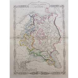
RUSSIA in EUROPE
This is the uncommon and slightly later edition by Rapkin based on Tallis' maps. The vignettes have been removed and the map is issued in black and white. A rare and desi...
Date: London, 1855
Selling price: ????
Please login to see price!
Sold in 2008
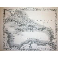
West India Islands
This is the uncommon and slightly later edition by Rapkin based on Tallis' maps. The vignettes have been removed and the map is issued in black and white. The map extends...
Date: London 1855
Selling price: ????
Please login to see price!
Sold
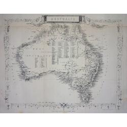
Australia.
This is the uncommon and slightly later edition by Rapkin based on Tallis' maps. The vignettes have been removed and the map is issued in black and white. With decorative...
Date: London 1855
Selling price: ????
Please login to see price!
Sold
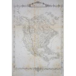
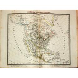
North America.
Important and uncommon later edition by Rapkin based on Tallis' maps. The vignettes have been removed and the map is issued in black and white. With decorative borders an...
Date: London 1855
Selling price: ????
Please login to see price!
Sold
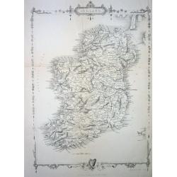
Ireland
This is the uncommon and slightly later edition by Rapkin based on Tallis' maps. The vignettes have been removed and the map is issued in black and white. With decorative...
Date: London 1855
Selling price: ????
Please login to see price!
Sold
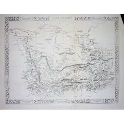
Cape Colony
This is the uncommon and slightly later edition by Rapkin based on Tallis' maps. The vignettes have been removed and the map is issued in black and white.With decorative ...
Date: London, 1855
Selling price: ????
Please login to see price!
Sold in 2008
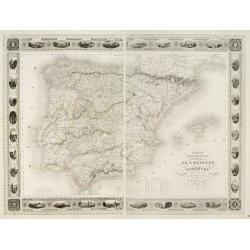
Carte Administrative, Physique et Routière De l'Espagne et du Portugal..
Steel engraving in 2 sheets representing the Iberian peninsula. Surrounded by a decorative frame composed by 32 views of Spanish towns.Title engraved by Ch. Simon.
Date: Paris, 1855
Selling price: ????
Please login to see price!
Sold
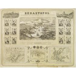
Sébastopol Vue Générale des Fortifications, du Port et de la Ville.
View of Sebastopol and its harbor, from the newspaper Le Siècle whose first issue was published in 1836. Surrounded by 2 views of Istanbul and St. Petersburg in the top ...
Date: Paris ca. 1855
Selling price: ????
Please login to see price!
Sold
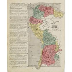
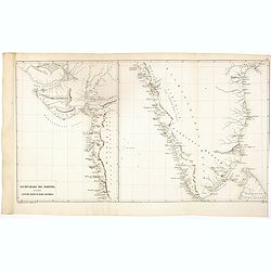
South America western part.
Map of western part of South America. From Sidney E. Morse''s: System of Geography for the use of schools , published by Harper and brothers, 329 Pearl Street, New York.A...
Date: New York, 1855
Selling price: ????
Please login to see price!
Sold in 2009
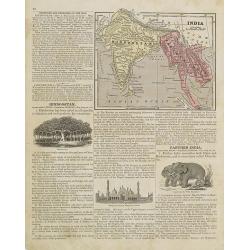
Persia and Arabia. / India and Malaysia.
Map of India and Malaysia. On the verso a map of Persia and Arabia (110x140mm.) . From Sidney E. Morse''s: System of Geography for the use of schools , published by Harpe...
Date: New York, 1855
Selling price: ????
Please login to see price!
Sold in 2011
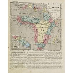
Africa.
Map of Africa. From Sidney E. Morse''s: System of Geography for the use of schools , published by Harper and brothers, 329 Pearl Street, New York.An 150 years old map wit...
Date: New York, 1855
Selling price: ????
Please login to see price!
Sold in 2008
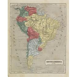
South America.
Map of the South American continent. From Sidney E. Morse''s: System of Geography for the use of schools , published by Harper and brothers, 329 Pearl Street, New York.An...
Date: New York, 1855
Selling price: ????
Please login to see price!
Sold in 2009
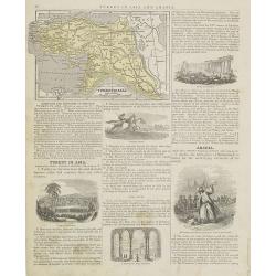
Turkey in Asia.
Map of Turkey. From Sidney E. Morse''s: System of Geography for the use of schools , published by Harper and brothers, 329 Pearl Street, New York.An 150 years old map wit...
Date: New York, 1855
Selling price: ????
Please login to see price!
Sold in 2009
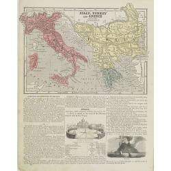
Italy, Turkey and Greece. / Holland and Belgium.
Map of Italy, Turkey and Greece. From Sidney E. Morse''s: System of Geography for the use of schools , published by Harper and brothers, 329 Pearl Street, New York.An 150...
Date: New York, 1855
Selling price: ????
Please login to see price!
Sold in 2009
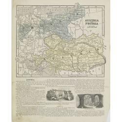
Austria and Prussia.
Map of Austria and Prussia. From Sidney E. Morse''s: System of Geography for the use of schools , published by Harper and brothers, 329 Pearl Street, New York.An 150 year...
Date: New York, 1855
Selling price: ????
Please login to see price!
Sold in 2008
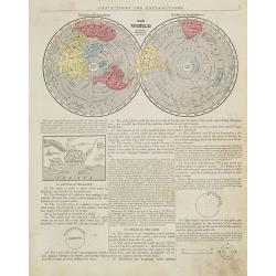
The World Northern & Southern hemisphere.
Map of the world presented in two northern and southern hemispheres. From Sidney E. Morse''''''''s: System of Geography for the use of schools , published by Harper and b...
Date: New York, 1855
Selling price: ????
Please login to see price!
Sold

New England Southern Part.
Map of the southern part of New England specifically of Massachusetts, Connecticut and Rhode Island and Boston and its vicinities. On the verso, a world map of North and ...
Date: New York, 1855
Selling price: ????
Please login to see price!
Sold in 2015
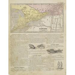
Canada.
Map of Canada. On the verso, a world map of North and South America with its northern and southern hemispheres. From Sidney E. Morse''s: System of Geography for the use o...
Date: New York, 1855
Selling price: ????
Please login to see price!
Sold in 2015
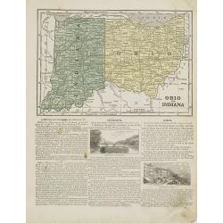
Ohio and Indiana.
Map of Ohio and Indiana. On verso a map of Iowa, Illinois and Missouri. From Sidney E. Morse''s: System of Geography for the use of schools , published by Harper and brot...
Date: New York, 1855
Selling price: ????
Please login to see price!
Sold in 2011
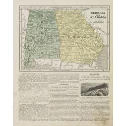
Georgia and Alabama.
Map of Georgia and Alabama. On verso a map of Louisiana, Mississippi and Arkansas. From Sidney E. Morse''s: System of Geography for the use of schools , published by Harp...
Date: New York, 1855
Selling price: ????
Please login to see price!
Sold in 2010
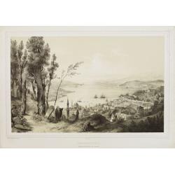
Constantinople - Vue prise de la tour du Séraskir.
Lithography on tinted grounds, with a panoramic view of the Bosphorus, with on foreground Istanbul. Printed by Wild, after a design of Bouquet and drawn on stone by Champ...
Date: Paris, ca 1855
Selling price: ????
Please login to see price!
Sold in 2013
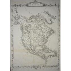
North America.
Important and uncommon later edition of Tallis map. The vignettes have been removed and the map is issued in black and white. Very detailed with numerous place names and ...
Date: London, c.1855
Selling price: ????
Please login to see price!
Sold in 2011
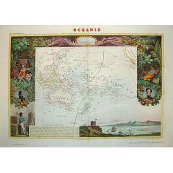
Oceania.
Beautiful steel plate map of the Oceania region. A very decorative work featuring depictions of indigenous peoples pursuing various activities, foliage and geographic sce...
Date: Paris, ca. 1855
Selling price: ????
Please login to see price!
Sold in 2010

Vista de la iglesia mayor y de la ermita del buenviaje.
Decorative view of the High Church and the Hermitage of Good Voyages at San Juan de los Remedios, by un unknown lithographer after Frederico Mialhe (1810-1881).He is know...
Date: Havana, ca. 1855
Selling price: ????
Please login to see price!
Sold in 2010
Siége de Sébastopol; Siege of Sebastopol.
Panoramic lithograph view of the city and port of Sevastopol (Crimea) being attacked by British and French troops during the war of 1854/1855.A very detailed and dramatic...
Date: Paris / Lyon, c1855
Selling price: ????
Please login to see price!
Sold in 2011
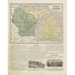
Michigan and Wisconsin
Map of Michigan and Wisconsin. Page 35/36 from Sidney E. Morse's: System of Geography for the use of schools , published by Harper and brothers, 329 Pearl Street, New Yor...
Date: New York 1855
Selling price: ????
Please login to see price!
Sold in 2011
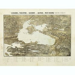
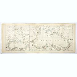
Panorama du théatre de la guerre sur les bords de la Mer Noir vu a vol d'oiseau.
Scarce plan and panoramic view of the Black Sea. With a numbered key (1-60) in lower part. Edited by Lémérey and E.Gratier. Printed with Gabiller and Molenaars.
Date: Paris, c.1855
Selling price: ????
Please login to see price!
Sold in 2011
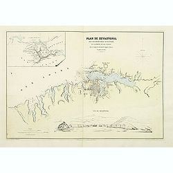
Plan de Sevastopol avec ses fortifications ses batteries et la portée de ses canons.
Map of the area around Sevastopol, engraved by Erhard and prepared by D.Ramee. Printed by Caillet. In the upper left corner is an inset plan of the Crimea. (380x555mm.). ...
Date: Paris, Caillet, 1855
Selling price: ????
Please login to see price!
Sold in 2011
Picture map of the Baltic sea.
Large wood block engraved map of the Baltic Sea and adjacent countries (Denmark, Sweden, Finland, Estonia, Latvia, Lithuania, Poland, Germany) with numerous vignettes to ...
Date: London, 1856
Selling price: ????
Please login to see price!
Sold in 2014
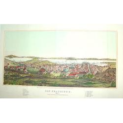
San Francisco
From Henry Bill's History of the World, a justly famous and sought after bird's-eye view of San Francisco published within seven years of the Gold Rush. It contains a leg...
Date: New York, 1856
Selling price: ????
Please login to see price!
Sold
Atlas Geográfico Universal.
Folio, hlf. leath., damaged.. With 42 double-page maps. Some staining, mainly in marges.A Spanish atlas with 42 maps ( a.o. 2 world maps, 7 maps of (parts of) the America...
Date: Barcelona, 1856
Selling price: ????
Please login to see price!
Sold
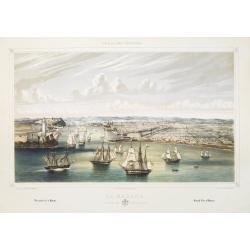
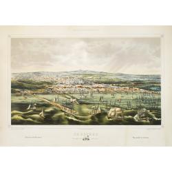
La Habana: vista general tomada desde la entrada del puerto.
A splendid, large lithographed view of the city of Havana as seen from the north, beautifully and subtly colored. The viewer is situated above the sea, looking into the m...
Date: Havana, Sergio Martin, 1856
Selling price: ????
Please login to see price!
Sold
Cardenas Vista general tomada desde la Bahia.
A splendid, large lithographed view of the city of Cardenas, beautifully and subtly colored. The viewer is situated above the sea, looking to the harbour. Dozens of boats...
Date: Havana, Sergio Martin, 1856
Selling price: ????
Please login to see price!
Sold

Trinidad Vista general tomada desde la loma de la Vijia.
A splendid, large lithographed view of the city of Trinidad, beautifully and subtly colored. The town is seen from above with in the background the Ocean. People in local...
Date: Havana, Gobierno, 1856
Selling price: ????
Please login to see price!
Sold
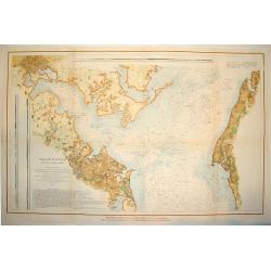
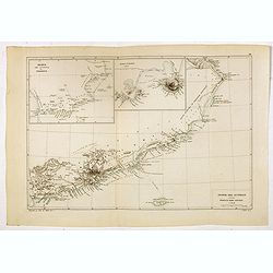
PATAPSCO RIVER AND THE APPROACHES
A large and wonderfuly detailed U. S. government chart of the Patapsco River and shoreline areas, including a finely engraved plan of Baltimore. The work contains a wealt...
Date: Washington D. C. , dated 1856
Selling price: ????
Please login to see price!
Sold
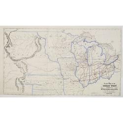
A New Map of the Great West Published by Miller, Orton & Mulligan, New York and Auburn. E. F. Beadle, Buffalo.
This map extends from Ohio to the Rocky Mountains, north of the Ohio River and Indian Territory, taken from "The States and Territories of the Great West", by J...
Date: Buffalo, 1856
Selling price: ????
Please login to see price!
Sold

La Glorieta, en el interior del bosque de Chapultepec.
Two-shades plate taken from : México y sus alrededores (Mexico, Decaen, Portal del Coliseo Viejo, 1855-1856). With a key in English, Spanish and French.
Date: Mexico,1855-1856
Selling price: ????
Please login to see price!
Sold in 2011

La villa de Tacubaya, Tomada desde Chapultepec.
Two-shades plate taken from : México y sus alrededores (Mexico, Decaen, Portal del Coliseo Viejo, 1855-1856). With a key in English, Spanish and French.
Date: Mexico,1855-1856
Selling price: ????
Please login to see price!
Sold in 2011

Las Cadenas en una noche de luna.
Two-shades plate taken from : México y sus alrededores (Mexico, Decaen, Portal del Coliseo Viejo, 1855-1856). With a key in English, Spanish and French.
Date: Mexico,1855-1856
Selling price: ????
Please login to see price!
Sold in 2011

Parti af St. Thomas.
A beautiful view of the capital town of St. Thomas on the island St. Thomas. This view shows much of the town and surrounding area. One of a series of six lithographs of ...
Date: Copenhagen, Baerentzen & Co, 1856
Selling price: ????
Please login to see price!
Sold in 2020