Browse Listings
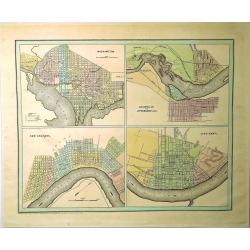
Washington, Louisville & Jefferson, New Orleans & Cincinnati.
Four city maps in full color. The map of Washington includes numbered locations including the Capitol, the State Department, Departments of War, Navy, and the Treasury, a...
Date: New York, 1838
Selling price: ????
Please login to see price!
Sold in 2019
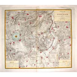
Batailles de Biberach Livrees Entre les Armees Francaises et Autricheinnes en 1796 et 1800.
Fine military map depicting the details of the battlefield of Biberach. It features fortifications and troop placements. Three plain block cartouches and unique compass r...
Date: Paris, 1839
Selling price: ????
Please login to see price!
Sold in 2015
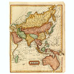
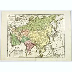
Asia.
Uncommon map of Asia and Australia, published in Boston for "Mitchill's School Atlas". Relief shown by hachure's.The map is of interest for the use of Gulf of C...
Date: Boston, Cummings & Hilliard, 1839
Selling price: ????
Please login to see price!
Sold in 2016
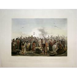
Scalp Dance of the Minatarris/ Scalptanz der Moennitarris/ Danse du Scalp des Indiens Meunitarris.
Print from: 'Reise in das innere Nord-America in den Jahren 1832 - 1834' by Prince Maximilian of Wied-Neuwied, after paintings by Karl Bodmer, engraved by Ch. Vogel, prin...
Date: London, 1839
Selling price: ????
Please login to see price!
Sold in 2015
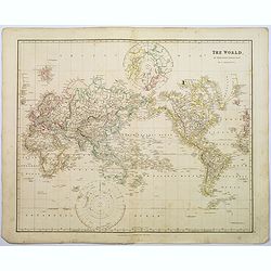
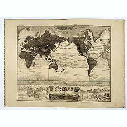
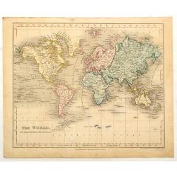
The World on Mercator's Projection.
A detailed steel engraved map of the World, as laid on Mercator's Projection. Each continent has a different color. Lands contiguous to both poles are shown. The map is w...
Date: London, 1839
Selling price: ????
Please login to see price!
Sold in 2018
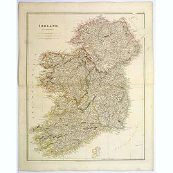
Ireland.
An attractive steel engraved map of Ireland, with each county divided by a different color. A pleasing amount of detail is provided. Also with a small inset map naming th...
Date: London, 1839
Selling price: ????
Please login to see price!
Sold in 2023
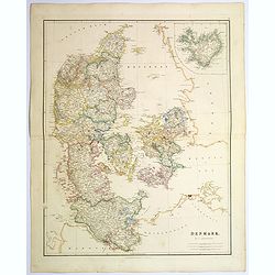
Denmark.
An attractive steel engraved map of Denmark, with an inset map of Iceland, which was then a Danish dependency. Many place names and physical features shown.The Arrowsmith...
Date: London, 1839
Selling price: ????
Please login to see price!
Sold in 2017
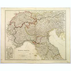
North Italy &c. . .
A large steel engraved map of Northern Italy, to include Switzerland, inset of the Italian Mediterranean island of Sardinia. Map extends as far south as the isle of Elba....
Date: London, 1839
Selling price: ????
Please login to see price!
Sold in 2017
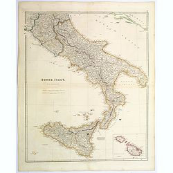
South Italy.
A large steel engraved map of South Italy, with an inset of the Maltese Islands. Map extends from Perugia, southward through Naples, continuing south to 'the boot', and i...
Date: London, 1839
Selling price: ????
Please login to see price!
Sold in 2020
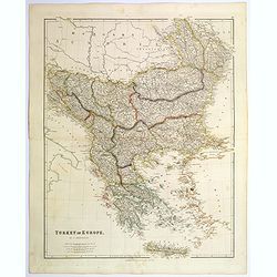
Turkey in Europe.
A large steel engraved map of Turkey in Europe, stretching from Croatia and Bosnia in the west across to the countries bordering the Black sea, southwards through mainlan...
Date: London, 1839
Selling price: ????
Please login to see price!
Sold in 2020
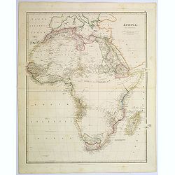
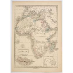
Africa.
A lovely looking steel engraved map of the mighty continent of Africa. The map highlights vividly how much exploration was carried on around the coastline, and how the va...
Date: London, 1839
Selling price: ????
Please login to see price!
Sold in 2017
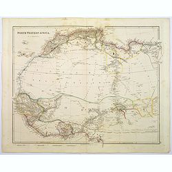
North Western Africa.
A lovely looking steel engraved map of the north western portion of Africa. The map highlights vividly how much exploration was carried on around the coastline, and how t...
Date: London, 1839
Selling price: ????
Please login to see price!
Sold in 2018
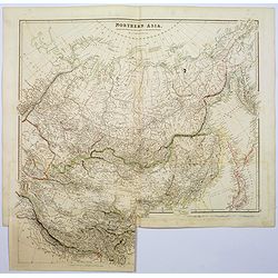
Northern Asia, from the Himalaya Mountains to the Arctic Ocean.
A lovely looking steel engraved map of Northern Asia, taking in Mongolia, Tibet, Bhutan, Tartary, Siberia and Manchuria. Part of Japan engraved also. Many place names and...
Date: London, 1839
Selling price: ????
Please login to see price!
Sold in 2018
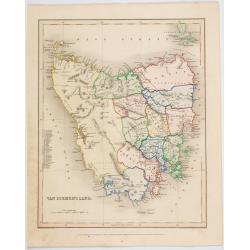
![Van Diemans Land [Tasmania].](/uploads/cache/38942-250x250.jpg)
Van Diemans Land [Tasmania].
A superb, large scale steel engraved map of what is today called Tasmania, an island to the far south off the Australian Mainland. Then, as now, the west coast is largely...
Date: London, 1839
Selling price: ????
Please login to see price!
Sold in 2017
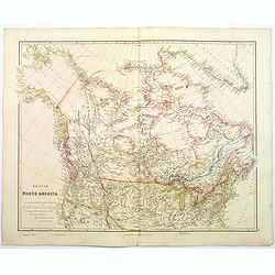
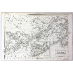
British North America.
A beautiful, large scale map of Canada, and the northern most states of America. Dedicated to the Hon. Hudsons Bay Company. It clearly shows the vastness of this fascinat...
Date: London, 1839
Selling price: ????
Please login to see price!
Sold in 2020
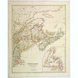
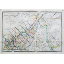
Lower Canada, New Brunswick, Nova Scotia, Prince Edward Island. . .
The prefix "lower" in its name refers to its geographic position farther downriver from the headwaters of the St. Lawrence River than its contemporary Upper Can...
Date: London, 1839
Selling price: ????
Please login to see price!
Sold in 2020
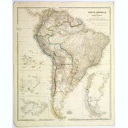
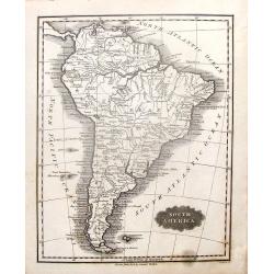
South America.
A striking steel engraved map of South America, with large, uncolored inset maps of The Galapagos Islands, Port San Carlos, Falkland Islands, and Patagonia. A tremendous ...
Date: London, 1839
Selling price: ????
Please login to see price!
Sold in 2017
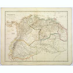
Colombia.
A large, detailed steel engraved map of the South American state of Colombia. This map of Colombia extends into modern day Venezuela to the east, and Ecuador to the south...
Date: London, 1839
Selling price: ????
Please login to see price!
Sold in 2020
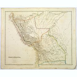
Peru & Bolivia.
A large, detailed steel engraved map of the South American states of Peru & Bolivia. Peru gained its independence from Spain in 1821. Bolivia was named after Simon Bo...
Date: London, 1839
Selling price: ????
Please login to see price!
Sold in 2017
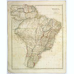
Brazil.
A large, detailed steel engraved map of the vast South American state of Brazil. The only Portuguese speaking colony in The Americas. It is the largest state in Latin and...
Date: London, 1839
Selling price: ????
Please login to see price!
Sold in 2017
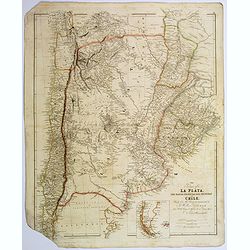
The Provinces of La Plata...and Chile.
A large, detailed steel engraved map of Chile and Argentina, together with Uruguay. Small inset map of Patagonia and Falkland Islands. Despite some map loss, the map is w...
Date: London, 1839
Selling price: ????
Please login to see price!
Sold in 2017
Exposition géographique en XIV tableaux, composés et expliqués par A. Legrand... Deuxième degré d'enseignement . . .
A series of 14 double-page plates with geographic representations, some with movable volvelles, followed by maps, each plate ca. 340 x 460mm, dark impressions and a few m...
Date: Paris, 1839
Selling price: ????
Please login to see price!
Sold in 2018

Magic Pile erected by the Assiniboin Indians.
This evocative and deeply spiritual engraving by Bodmer shows a cairn (human made stack, or pile of stones, rocks) topped with the skull of a buffalo, made by the Assinib...
Date: Pars, Coblenz, London, 1839
Selling price: ????
Please login to see price!
Sold in 2017
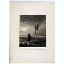
Offrande des Indiens Mandans.
This bleak, evocative and deeply spiritual engraving by Bodmer shows a Mandan skull shrine in 1833, located near the burial ground of Mih-Tutta-Hang-Kusch.Titles in Germa...
Date: Pars, Coblenz, London, 1839
Selling price: ????
Please login to see price!
Sold

Magic Pile erected by the Assiniboin Indians.
This evocative and deeply spiritual engraving by Bodmer shows a cairn (human made stack, or pile of stones, rocks) topped with the skull of a buffalo, made by the Assinib...
Date: Pars, Coblenz, London, 1839
Selling price: ????
Please login to see price!
Sold in 2019
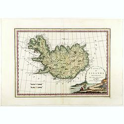
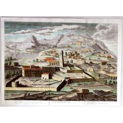
L'Isola d'Islanda Delineata Sulle ultime osservazioni.
Cassini’s splendid map depicts Iceland at the end of the eighteenth century. Though Iceland was geographically isolated from the European continent, for centuries it wa...
Date: Rome, 1796- before 1839
Selling price: ????
Please login to see price!
Sold in 2018
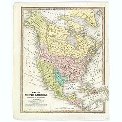
Map of North America. . .
An uncommon schoolboy map of North America, showing TX as a republic, and Alaska as "Russian Possessions." Mexico still extends well into today's California and...
Date: Hartford, ca 1839
Selling price: ????
Please login to see price!
Sold in 2018
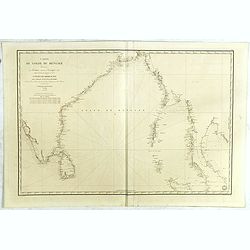
Carte du Golfe du bengale dressée par Mr daussy, ingénieur hydrographe en chef, d'après les travaux les plus récents. . .
Large sea chart showing the Gulf of Bengal with India, Ceylon and Thailand with the Gulf of Siam to the right. The chart was engraved by E. Collin and Chassant for the D�...
Date: Paris, 1839
Selling price: ????
Please login to see price!
Sold in 2020
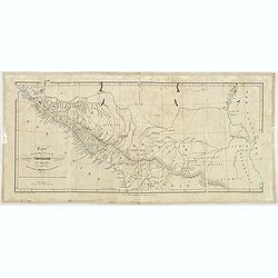
Carte itinéraire du Prince Maximilien..
Engraved map of the interior of the Northern U.S., from Atlantic seaboard to the Rocky Mountains with outline coloring indicating the route of travels and Indian nations....
Date: Paris, Coblenz, or London, 1839
Selling price: ????
Please login to see price!
Sold

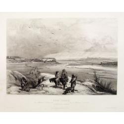
Cutoff-River - Branch of the Wabash.
Original aquatint engraving for Travels in the Interior of North America between 1832-34 . Engraved by L.Weber. The finest work on American Indian life and the American F...
Date: London / Paris / Coblenz, 1839
Selling price: ????
Please login to see price!
Sold in 2009

Cave in Rock- view on the Ohio.
Original aquatint engraving for Travels in the Interior of North America between 1832-34 . Engraved by Lucas Weber. The finest work on American Indian life and the Americ...
Date: London/Paris/Coblenz, 1839
Selling price: ????
Please login to see price!
Sold in 2020
![[Manuscript] Asie - Janvier 1839.](/uploads/cache/23276-250x250.jpg)
[Manuscript] Asie - Janvier 1839.
Fine manuscript map of Asia with relief shown pictorially. The Oceans in wash color and the borders in different colors. Dated 1839 and signed by the author in the lower ...
Date: France, 1839
Selling price: ????
Please login to see price!
Sold in 2009
Amérique - Fevrier 1839
Fine manuscript map of America with relief shown pictorially. The Oceans in wash color and the borders in different colors. Dated 1839 and signed by the author ShuardLowe...
Date: Paris, 1839
Selling price: ????
Please login to see price!
Sold in 2016
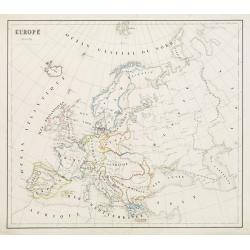
Europe - Mars 1839
Fine manuscript map of Europe with relief shown pictorially. The Oceans in wash color and the borders in different colors. Dated 1839 and signed by the author in the lowe...
Date: Paris, 1839
Selling price: ????
Please login to see price!
Sold in 2009
![[Manuscript] Afrique - Janvier 1839.](/uploads/cache/23282-250x250.jpg)
[Manuscript] Afrique - Janvier 1839.
Fine manuscript map of Africa with relief shown pictorially. The Oceans in wash color and the borders in different colors. Dated 1839, and signed by the author in the low...
Date: Paris 1839
Selling price: ????
Please login to see price!
Sold
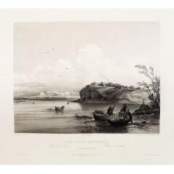
Fort Clark on the Missouri (February 1834)
Original aquatint engraving for Travels in the Interior of North America between 1832-34 . Engraved by Lucas Weber. The finest work on American Indian life and the Americ...
Date: London/Paris/Coblenz, 1839
Selling price: ????
Please login to see price!
Sold
Mih-Tutta-Hangkusch a Mandan Village.
Original aquatint engraving for Travels in the Interior of North America between 1832-34 . Engraved by Lucas Weber. The finest work on American Indian life and the Americ...
Date: London/Paris/Coblenz, 1839
Selling price: ????
Please login to see price!
Sold
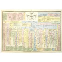
Tableau chronologique de l'histoire de France par P.J Ferrand.
An extensive timetable of France with a wealth of historical information until the year 1811. Prepared by P.J.Ferrand, engraved by Ch. Simon and published by Auguste Loge...
Date: Paris, c.1839
Selling price: ????
Please login to see price!
Sold in 2020
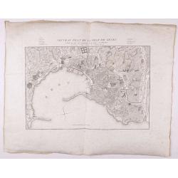
Nouveau Plan de la ville de Gênes corrigé de tous les changements faits jusqu'à ce jour.
Detailed plan of Genova., with in top a numbered key. Large margins.
Date: Genova, 1839
Selling price: ????
Please login to see price!
Sold in 2021
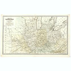
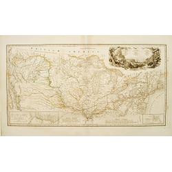
Map of the Western States designed to accompany Smith's Geography for Schools.
A detailed map of the American Midwest, published before the formation of Minnesota. It depicts individual counties, towns, roads, rivers, mountains, etc. Worth noting is...
Date: Chicago, 1839
Selling price: ????
Please login to see price!
Sold in 2020
![[BALKANS 1839] HARTIS TIS TOYRKIAS KAI ELLADOS. . . BIENNI 1839.](/uploads/cache/85299-250x250.jpg)
[BALKANS 1839] HARTIS TIS TOYRKIAS KAI ELLADOS. . . BIENNI 1839.
A very rare copper engraved map of the southern Balkans - European Turkey and Greece, by K.M.Koyma, for the Greek edition of the Geography by A.Balbi, 1839 in Vienna. Cov...
Date: Vienna, 1839
Selling price: ????
Please login to see price!
Sold in 2021
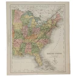
Eastern Division of the United States.
A fine chromolithograph map of the Eastern United States and parts of Canada. The Sioux, Fox, Chippewa and Algonquin Indian tribes are all mentioned. The capital of Arkan...
Date: London, 1840
Selling price: ????
Please login to see price!
Sold in 2021
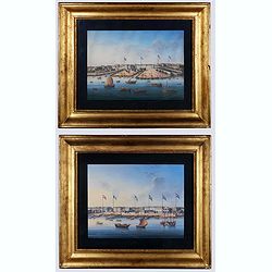
Canton. (Two gouaches).
Two so-called export paintings of the Thirteen Factories at Canton (Guangzhou). The flags of Denmark, France, the U.S., Sweden, Britain, and the Netherland are visible on...
Date: China, ca. 1840
Selling price: ????
Please login to see price!
Sold in 2020
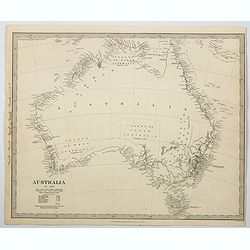
Australia.
An uncolored map of the continent of Australia in 1839, but published a year later in 1840, from the S.D.U.K. publication in London. The map identifies the years and name...
Date: London, 1840
Selling price: ????
Please login to see price!
Sold in 2023
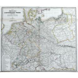
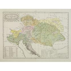
Map of the Germanic Confederated States, including the Kingdom of Prussia, as Settled by the Act of Congress at Vienna, June 9th 1815.
Large and detailed map of central Europe. From France until Poland, Russia, Lithuania and Hungary. And from Denmark until Venice and Belgrade. With areas, roads, rivers, ...
Date: London, c1840
Selling price: ????
Please login to see price!
Sold in 2020
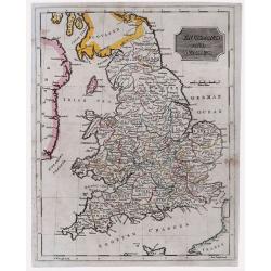
England & Wales.
Highly detailed map of England & Wales. The map provides good topographic details. The title is inside a frame-style cartouche. By F.W. Topham in London in 1840.
Date: London, 1840
Selling price: ????
Please login to see price!
Sold in 2021
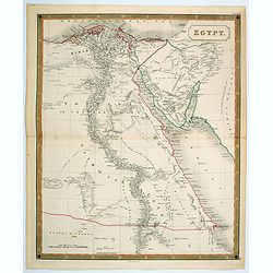
Egypt.
A nice, large scale map of Egypt, published by Longman & Co. toward the middle of the 19th century. Unsurprisingly, most of the cartographic detail centers around the...
Date: London, 1840
Selling price: ????
Please login to see price!
Sold in 2021
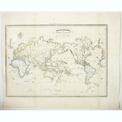
Mappamondo sulle Projezione di Mercator…da Diaz, Gama, Colombo, e Magellano.
An Italian 'Mercator's Projection' map of the world, published around the middle of the 19th-century. As the title indicates, the map highlights the routes taken by vario...
Date: Italy, ca 1840
Selling price: ????
Please login to see price!
Sold in 2023
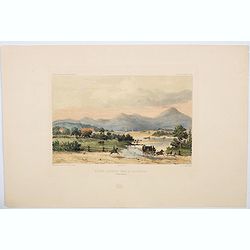
Riviere Derwent pres de Richemont.
An attractive hand colored lithograph showing the River Derwent at Richmond, which lies about 25 kms north-east of Hobart in Tasmania. The lithograph depicts a beautiful,...
Date: Paris, ca 1840
Selling price: ????
Please login to see price!
Sold in 2023
Africa.
Sidney Hall's general map of the continent of Africa, published during the first half of the 19th century by A & C Black in Edinburgh. The map features two inset maps...
Date: Edinburgh, ca 1840
Selling price: ????
Please login to see price!
Sold in 2023
Van Diemen's Land.
A map of Van Diemen's Land (Tasmania) beautifully drawn and engraved by Joshua Archer in London for Grattan & Gilbert's "Modern Atlas".A small numbered tabl...
Date: London, 1840
Selling price: ????
Please login to see price!
Sold in 2023
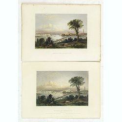
Boston, and Bunker Hill.
Two views of Boston and Bunker Hill. The artist was W. H. Bartlett (1809-1854), the English landscape painter who traveled widely in his short life, producing images of l...
Date: London, George Virtue, 1840
Selling price: ????
Please login to see price!
Sold in 2013
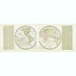
( Double hemisphere world map)
A rare and detailed double hemisphere world map. According to the title cartouche, prepared by A de La Sage for l'Atlante Storico, Letterario, Biografico, Archeologico. ....
Date: Venice, 1840
Selling price: ????
Please login to see price!
Sold in 2016
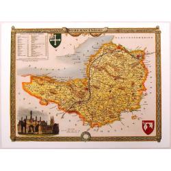
Somersetshire.
Nice hand-colored map of Somersetshire with a fine engraving cartouche of Glastonbury Cross. It also has two coats of arms. Thomas Moule (1784 - January 1851) was an Eng...
Date: London, 1840
Selling price: ????
Please login to see price!
Sold in 2013
Carte pour l'intelligence du journal d'une résidence en Circassie during the years 1837, 1838 and 1839.
Map of Circassia prepared by James Stanislaus Bell. Engraved by Barriére, 57 rue de la Harpe, Paris. James Stanislaus Bell was a British merchant. In his work Journal of...
Date: Paris, Arthus Bertrand, after 1840
Selling price: ????
Please login to see price!
Sold in 2013
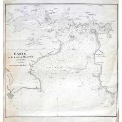
Carte de la rade de Plymouth avec le Môles excuté par l. ingénieur John Renie.
Rare sea-chart of the Plymouth Sound, engraved by Edler. With numerous depth soundings, shoals, buoys, and important landmarks including relevant buildings such as: Tarpo...
Date: unknown, c1840
Selling price: ????
Please login to see price!
Sold in 2018
L'Impero Austriaco . . .
A rare and detailed double-page map of Austrian Empire, including Northern Italy, Hungary, Czech Republic, etc. From l'Atlante Storico, Letterario, Biografico, Archeologi...
Date: Venice, 1840
Selling price: ????
Please login to see price!
Sold in 2014

S.Marco.
Lithography in original colors of the basilica San Marco in Venice. The Patriarchal Cathedral Basilica of Saint Mark (officially known in Italian as the Basilica Cattedra...
Date: Venise, c. 1840
Selling price: ????
Please login to see price!
Sold in 2017
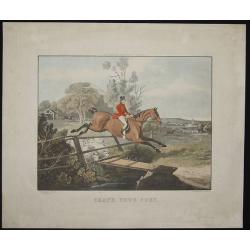
That's your sort.
Copper engraved hunting scene.
Date: London, 1840
Selling price: ????
Please login to see price!
Sold in 2014
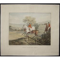
Yooi - over he goes!
Copper engraved hunting scene.
Date: London, 1840
Selling price: ????
Please login to see price!
Sold in 2014
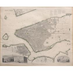
NEW YORK.
A detailed mid-19th century plan of the City of New York including Manhattan, Brooklyn, Governor's Island with parts of Jersey City and Williamsburg which was published u...
Date: London, 1840
Selling price: ????
Please login to see price!
Sold in 2016
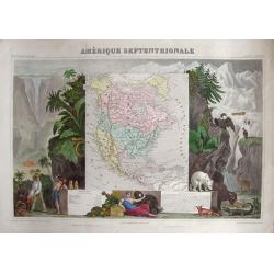
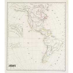
Amérique Septentrionale.
Very attractive map of America. To the left we find traders negotiating home-made products and a Maya pyramid. To the right we find plants and animals that are common for...
Date: Paris, 1840
Selling price: ????
Please login to see price!
Sold in 2014
(Manuscript) Plan du port de Bombay.
French manuscript map of Bombay harbor complete with anchorage point at Bombay. The map is likely based on Jean B.N.D. D'Apres de Mannevillette: "Plan du Port de Bom...
Date: France or India, c. 1840
Selling price: ????
Please login to see price!
Sold in 2015
The World on Mercators Projection.
Fine hand-colored world map by
Date: London, 1840
Selling price: ????
Please login to see price!
Sold in 2016
South America.
Pleasing map featuring "South America". Engraved by G. Boynton and published in Boston by Samuel Walker in about 1840.
Date: Boston, c1840
Selling price: ????
Please login to see price!
Sold in 2014
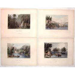
(Four hand-colored Bartlett Engravings of Canadian Country Scenes.)
Included are four scenes of Canada including:- "Indian Scene" engraved by J.C. Armatage,- "A First Settlement" engraved by J.C. Bentley,- "A Lake...
Date: New York, ca. 1840
Selling price: ????
Please login to see price!
Sold in 2019
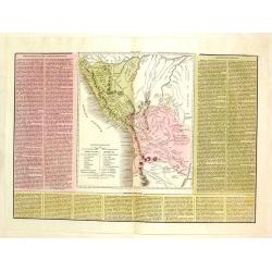
Le Due Repubbliche cioe La Confederazione Peruvian et Bolivia.
A rare, detailed map of Peru and Bolivia. The map is surrounded by explanatory historical text. Tasso's map was prepared by J.A. Buchon and A de la Sage for "L'ATLAN...
Date: Venice, 1840
Selling price: ????
Please login to see price!
Sold in 2017
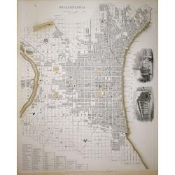
Philadelphia SDUK
A highly detailed mid-19th century plan of the city of Philadelphia by the Society for the Diffusion of Useful Knowledge.It depicts the entire city in remarkable detail, ...
Date: London, 1840
Selling price: ????
Please login to see price!
Sold in 2018
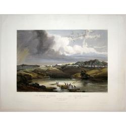
The White Castles on the Upper Missouri/ Die Weissen Schloesser am oberen Missouri/ Les Chateaux Blancs Missouri superior.
Aquatint from: 'Reise in das innere Nord-America in den Jahren 1832 - 1834' by Prince Maximilian of Wied-Neuwied, after paintings by Karl Bodmer, engraved by Himely, prin...
Date: London, 1840
Selling price: ????
Please login to see price!
Sold in 2015
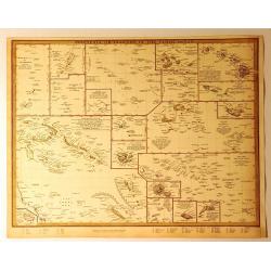
Polynesia or Islands in the Pacific Ocean.
A 1840 S.D.U.K. map of the islands of the Pacific Ocean or Polynesia. It has a total of 19 miniature maps on one sheet covering the Mariana Islands, the Pelew Islands, G...
Date: Chicago, 1840
Selling price: ????
Please login to see price!
Sold in 2018
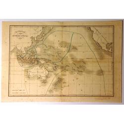
Oceanie
Interesting map of Oceania featuring Australia, Micronesia, Malaysia and Polynesia. It also has the south-west coast of America with a strange looking California. There i...
Date: Paris, 1840
Selling price: ????
Please login to see price!
Sold in 2015
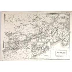
Canada, New Brunswick & c.
Fine map of Maritime part of Canada from Adam & Black's "General Atlas" published in Edinburgh in 1840.It includes Upper (Ontario) & Lower (Quebec) Cana...
Date: Edinbugh. 1840
Selling price: ????
Please login to see price!
Sold in 2015
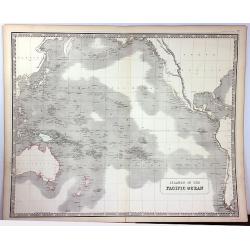
Islands of the Pacific Ocean
A detailed map of the Pacific Ocean that identifies hundreds of islands. The map includes Australia, North America, and parts of Asia and South America. Detail is confine...
Date: Edinburgh, 1840
Selling price: ????
Please login to see price!
Sold in 2016
Canada, New Brunswick & c.
A fine example of Adam and Charles Black's map of Canada. It covers from Malden to Cape Breton Island in Nova Scotia. The continuation of Nova Scotia is included in an in...
Date: Edinburgh, 1840
Selling price: ????
Please login to see price!
Sold in 2016
Plan de la Ville de Nazareth
A fine map of the city of Nazareth by P. Bellier in Paris in about 1840.Taken from his "GEOGRAPHIC ATLAS & ICONOGRAPHIC FULL COURSE OF SCRIPTURE". There is ...
Date: Paris, ca. 1840
Selling price: ????
Please login to see price!
Sold in 2016
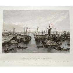
Entrance of the Hoang-ho, or Yellow River.
Superb view of the mouth of the Yellow River or Huáng Hé in the Bohai Sea (a gulf of the Yellow Sea). With numerous very detailed boats and ships shown. Engraved by Adl...
Date: London, ca. 1840
Selling price: ????
Please login to see price!
Sold in 2016
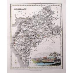
Cumberland.
Highly detailed map of the county, with a nice view of Carlisle shown from the North East. The map shows towns and villages, streets, lakes, rivers, forests, hills, etc. ...
Date: Glasgow, c1840
Selling price: ????
Please login to see price!
Sold in 2016
Quebec or Province of Lower Canada, Describing all the Seigneuries, Townships, Grants of Land, &c...
A large and important map of lower Canada, by or after Wyld, illustrating the land grants on either side of the St. Lawrence River. The boundary line of the United States...
Date: London, ca 1840
Selling price: ????
Please login to see price!
Sold in 2017
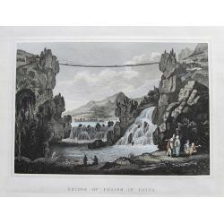
Bridge of Chains in China.
An interesting scene with a rope bridge over waterfalls. In the front several people are seen, including one angling.With nice hand color.
Date: London, ca 1840
Selling price: ????
Please login to see price!
Sold in 2017
L'Asia . . .
A rare and detailed double-page map of Asia. According to the title cartouche, prepared by A de La Sage for l'Atlante Storico, Letterario, Biografico, Archeologico. . . ...
Date: Venice, 1840
Selling price: ????
Please login to see price!
Sold in 2017