Browse Listings
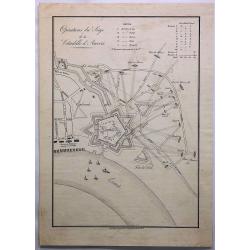
Operations du Siege de la Citadelle d'Anvers.
A fine engraving of the siege of Antwerp, Belgium in 1832. The citadel of Antwerp, also known as the South Castle, is a citadel and fortress which was located to the sout...
Date: Amsterdam, ca. 1840
Selling price: ????
Please login to see price!
Sold in 2019
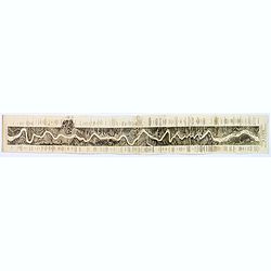
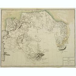
Panoramic Map of the Rhine from Cologne to Meyence.
A lovely long panoramabird's eye viewshowing the route from Cologne to Meyence, engraved to accompany Tombleson's view books on the Upper Rhine. Panorama is flanked on ei...
Date: London, ca. 1840
Selling price: ????
Please login to see price!
Sold in 2018
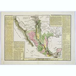
Confederazione Messicana . . .
A rare and detailed double-page map of Mexico. Map is surrounded by an explanatory historical text about the regions in a yellow background color.According to the title c...
Date: Venice, 1840
Selling price: ????
Please login to see price!
Sold in 2018
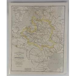
Carte Generale des Etats de la Republique Polonaise.
Original map on steel, engraved by A. Marcinkiewicz after Léonard Chodzko. It shows the expeditions of Varles XII at the beginning of the 18th century.Leonard Chod&#...
Date: Paris, 1840
Selling price: ????
Please login to see price!
Sold in 2018

Captain James Cook.
Fine steel engraved portrait of Captain Cook one of the most famous explorers and cartographers. It is from the original picture by Dance in the Gallery of Greenwich Hosp...
Date: London, 1840
Selling price: ????
Please login to see price!
Sold in 2017
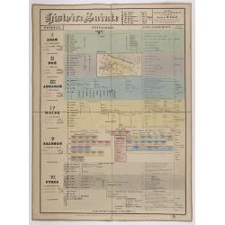
Histoire Sainte, 1840, Cours encyclopédiques - 28e Année - Méthode de Mr Colart . . .
Fine genealogic sheet for educational purpose, about Jewish history. From Adam to Cyrus. In top a map of "Palestine ou Terre Promise en 12 Tribes" 135 x 70mm.
Date: Paris, 1840
Selling price: ????
Please login to see price!
Sold in 2017

Südlicher theil des Heidelberg schlosses . . . Façade du midi du château de Heidelberg . . .
Early aquatint after Louis Charles François de Graimberg-Belleau. Lithographed by Hibon and Paul Legrand.French artist. Son of Gilles-François Belleau Graimberg. Louis ...
Date: Graimberg, Heidelberg, ca. 1840
Selling price: ????
Please login to see price!
Sold in 2018

Westlicher theil des Heidelberg schlosses . . . Façade de l'ouest du château de Heidelberg . . .
Earlyaquatint after Louis Charles François de Graimberg-Belleau. Lithographed by Hibon and Paul Legrand.French artist. Son of Gilles-François Belleau Graimberg. Louis C...
Date: Graimberg, Heidelberg, ca. 1840
Selling price: ????
Please login to see price!
Sold in 2018
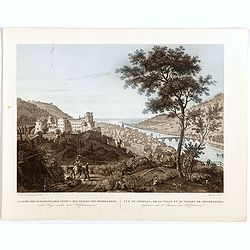
Ansicht des schlosses, der stradt u. des thales von Heidelberg . . . Vue du château, de la ville et du vallon de Heidelberg . . .
Early aquatint after Louis Charles François de Graimberg-Belleau. Lithographed by Salathé.French artist. Son of Gilles-François Belleau Graimberg. Louis Charles Franç...
Date: Graimberg, Heidelberg, ca. 1840
Selling price: ????
Please login to see price!
Sold in 2018
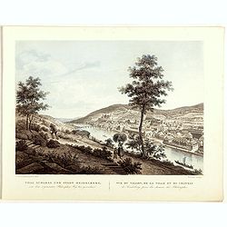
Thal schloss und stadt Heidelberg . . . Vue du vallon, de la ville et du château de Heidelberg . . .
Early lithographs after Louis Charles François de Graimberg-Belleau. Lithographed by Salathé.French artist. Son of Gilles-François Belleau Graimberg. Louis Charles Fra...
Date: Graimberg, Heidelberg, ca. 1840
Selling price: ????
Please login to see price!
Sold in 2018
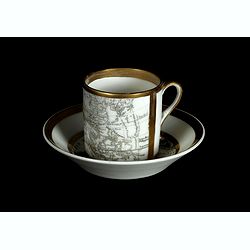
Coffee cup and plate with map design.
The coffee cup has a map of the eastern part of the globe from Europe up to Asia, including China and Korea with a "Mer de Cor(ée)" for the sea between Japan a...
Date: England, ca.1840
Selling price: ????
Please login to see price!
Sold in 2018
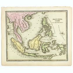
East India Isles.
Somewhat later but very finely engraved and detailed map of south-east Asia, including modern day Myanmar (Burma), Thailand, Cambodia, Vietnam, Singapore, Malaysia, Indon...
Date: 1840
Selling price: ????
Please login to see price!
Sold in 2018
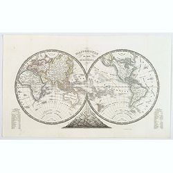
Mappemonde en deux Hemispheres.
A nice mid nineteenth century French twin hemisphere map of the world, published in by Monin. Continent boundaries in different colors, tables of comparative world mounta...
Date: Paris, 1840
Selling price: ????
Please login to see price!
Sold in 2018
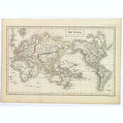
The World on Mercator's Projection.
A fine example of Adam and Charles Black's 1840 map of the world on Mercator's Projection. An interesting map of the world issued just as most of the earth's non-polar sh...
Date: London, 1840
Selling price: ????
Please login to see price!
Sold in 2018
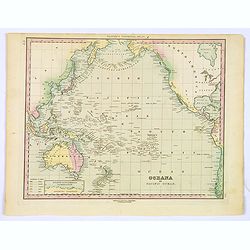
Oceana or Pacific Ocean.
A lovely detailed map of the Pacific, centered on Hawaii, from an early edition of Tanner's New Universal Atlas.
Date: Philadelphia, ca 1840
Selling price: ????
Please login to see price!
Sold in 2019
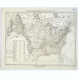
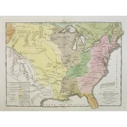
Vereinigte Staaten von Nord-America.
This handsome German map highlights the United States and her Territories, as numbered and outlined in yellow. The Republic of Texas (an independent nation until joining ...
Date: Glogau, ca 1840
Selling price: ????
Please login to see price!
Sold in 2020
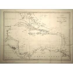
Carta Delle Indie Occidentali, per Servire Viaggi di Christoforo Colombo.
Interesting and informative map of the West Indies including the detailed voyages of Christopher Columbus. The map is by Francesco Marmocchi and is in Italian text. Fran...
Date: Italy 1840
Selling price: ????
Please login to see price!
Sold in 2019

In congress, July 4, 1776. The unanimous declaration of the thirteen united Styates of America.
Scarce French reproduction based on William J. Stone’s official copperplate facsimile done by order of Congress. This French edition of the Declaration of Independance ...
Date: Paris, Kaeppelin & Cie, 1840
Selling price: ????
Please login to see price!
Sold in 2019
![The dissolution; or the Alchymist producing an Aetherial Representation. (150). [with] JOHN BULL & his Dog Faithfull. . .](/uploads/cache/44192-250x250.jpg)
The dissolution; or the Alchymist producing an Aetherial Representation. (150). [with] JOHN BULL & his Dog Faithfull. . .
Caricature after James. Gillray. Plate 148 and 150, an original James Gillray copper engraving (1847-1851) from "The Works of James Gillray from the Original 18th Ce...
Date: Henry G. Bohn, London, 1840
Selling price: ????
Please login to see price!
Sold in 2022

Doctor Sangrado curing John Bull of repletion-with the kind offices of young Clysterpipe & little Boney- a hint from Gil Blas. (pl 274) / verso: A Phantasmagoria - scene conjuring up an armed skeleton.
Caricature by Gillray based on a character from the novel 'Gil Blas' by Alain-Rene Lesage where Dr Sangrado prescribes warm water and bleeding for every ailment. Dr Sangr...
Date: Henry G. Bohn, London, 1840
Selling price: ????
Please login to see price!
Sold in 2019
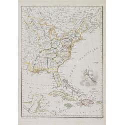
États Unis et Grandes Antilles.
America's east coast, the Great Lakes, Florida and the Caribbean.
Date: Paris, 1840
Selling price: ????
Please login to see price!
Sold in 2017
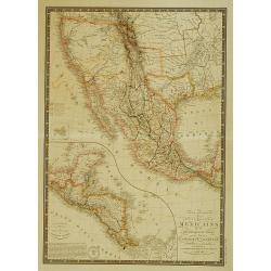
Carte générale des États-Unis Mexicains, de la République du Texas..
Map of Texas, Mexico and the South-West. Rare mention of the Republic of Texas in the title.Excellent pre-Fremont cartography in Upper or New California, although the 3 r...
Date: Paris 1840
Selling price: ????
Please login to see price!
Sold
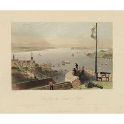
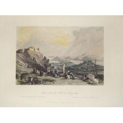
View from the Citadel of Quebec.
Fine view of the city of Quebec. Engraved by R.Wallis, published by G.Virtne.
Date: London, 1840
Selling price: ????
Please login to see price!
Sold in 2012
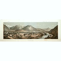
Interlaken.
Decorative panoramic view of the town of Interlaken, with in left hand corner the mountain Jung-Frau.Lithographed by Deroy.
Date: Paris, ca. 1840
Selling price: ????
Please login to see price!
Sold
Kust Van Afrika van de Tafel Baay aan Kaap de Goede Hoop tot de Saldanha Baay.
Detailed map of the coast of South Africa from Saldanha Bay till Tafel Bay. Including the islands Robben Island and Dassen Island. Engraved by Daniel Veelwaard and publis...
Date: Haarlem c. 1840
Selling price: ????
Please login to see price!
Sold
Militair plan van de Kaapsche Landengte?
Detailed map of the Cape of Good Hope. Engraved by Daniel Veelwaard and published by F.Bohn.
Date: Haarlem c.1840
Selling price: ????
Please login to see price!
Sold
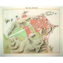
Rio de Janeiro
A handsome, seldom seen early 19th century plan of Rio de Janeiro and its famous bay. The map identifies the city's major thoroughfares, expanses and important points of ...
Date: Paris, ca. 1840
Selling price: ????
Please login to see price!
Sold in 2008

Washington.
Steel engraved portrait of Georges Washington, engraved by Ballin. Published by Dufour, Mulat et Boulanger Imp. Gilquin et Dupain, r. de la Calandre, 19, Paris.
Date: Paris ca 1840
Selling price: ????
Please login to see price!
Sold
Macao from the Forts of Heang-shan.
A finely delineated view of the city of Macao as seen from one of its fortification areas. The foreground contains a group of religious worshipers. Engraved by S. Fisher....
Date: London, ca. 1840
Selling price: ????
Please login to see price!
Sold in 2011
![[Irises].](/uploads/cache/26089-250x250.jpg)
[Irises].
Plate from William Curtis (1746-1799) "The Botanical Magazine". The publication began in February 1787 and was immediately successful, and the early volumes wer...
Date: London, 1840
Selling price: ????
Please login to see price!
Sold in 2019
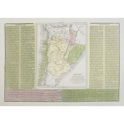
Confederazione del Chili, Stati Uniti Sulrio Plata, dittatorato del Paraguai, Repubblica Orientale dell'Urugai.
A rare and detailed double-page map of Chili, Paraguay and Uruguay. The map is surrounded by an explanatory historical text about the countries in green, yellow and pink ...
Date: Venice, 1840
Selling price: ????
Please login to see price!
Sold in 2019
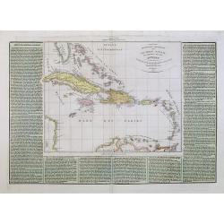
Arcipelago Colombiano cioe Le Isole Lucaje Le Grandi e Piccole Antille.
A rare and detailed double-page map of the Caribbean. The map is surrounded by an explanatory historical text about the countries in a green hand colored background color...
Date: Venice, 1840
Selling price: ????
Please login to see price!
Sold in 2021
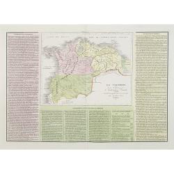
La Colombia . . .
A rare and detailed double-page map of Colombia, Bolivia and Venezuela. The map is surrounded by an explanatory historical text about the countries in pink, yellow and gr...
Date: Venice, 1840
Selling price: ????
Please login to see price!
Sold in 2011
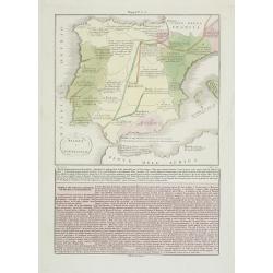
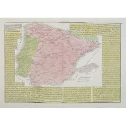
Spagna e Portugallo . . .
A rare map of ancient Spain and Portugal.From l'Atlante Storico, Letterario, Biografico, Archeologico. . . with attributions by Giambatista Albrizzi.Engraved by P.Zulian...
Date: Venice, 1840
Selling price: ????
Please login to see price!
Sold in 2009
La Spagna ed il Portugallo. . .
A rare map of ancient Spain and Portugal.From l'Atlante Storico, Letterario, Biografico, Archeologico. . . with attributions by Giambatista Albrizzi.Engraved by P.Zulian...
Date: Venice, 1840
Selling price: ????
Please login to see price!
Sold in 2009
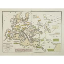
Transmigrazioni ed invasioni de\' Barbari . . .
A rare double-page map of Barbarian invasion.According to the title cartouche, prepared by A de La Sage for l\'Atlante Storico, Letterario, Biografico, Archeologico. . . ...
Date: Venice, 1840
Selling price: ????
Please login to see price!
Sold in 2009

Tour d'Observation et siège de police dans la grande Morskoi. (2 Juillet 1839).
A view of Observation Tower and police headquarters in the Morskoi in Saint Petersburg on August 9 1839. Plate taken from the first illustrated account of Russian archite...
Date: Paris, 1840
Selling price: ????
Please login to see price!
Sold in 2013
Stati-Uniti Dell'America settentrionale . . .
A rare and detailed double-page map of eastern part of the United States of America, including Great Lakes, Florida, engraved by G.V.Pasquali. According to the title cart...
Date: Venice, 1840
Selling price: ????
Please login to see price!
Sold in 2016
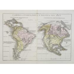
L'America Storica, Fisica e Politica nel 1825.
A rare and detailed double-page map of North and South America. From l'Atlante Storico, Letterario, Biografico, Archeologico. . . with attributions by Giambatista Albriz...
Date: Venice, 1840
Selling price: ????
Please login to see price!
Sold in 2014

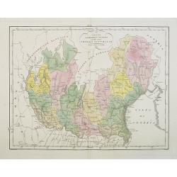
America Settentrionale disegnata dopi i viaggi di Lewis, Clarke, Parry e Franklin. . .
A rare and detailed double-page map of eastern part of the United States of America, including Great Lakes, Florida, engraved by G.V.Pasquali.According to the title carto...
Date: Venice, 1840
Selling price: ????
Please login to see price!
Sold in 2018
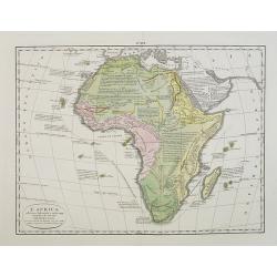
L'Africa. . .
A rare double-page map of the African continent. According to the title cartouche, prepared by A de La Sage for l'Atlante Storico, Letterario, Biografico, Archeologico. ....
Date: Venice, 1840
Selling price: ????
Please login to see price!
Sold in 2009
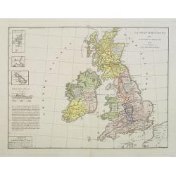
La Gran Brettagna . . . .
A rare and detailed double-page map of Great Britain with three inset maps upper left of the Shetland Mainland Islands, the Helgoland Island (occupied by the English in 1...
Date: Venice, 1840
Selling price: ????
Please login to see price!
Sold in 2011
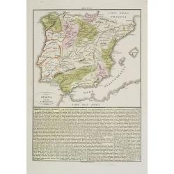
Spagna e Portogallo.
A rare and detailed double-page map of Spain and Portugal, showing the battlefields during the years 1817 until 1814. The map is surrounded by an explanatory historical t...
Date: Venice, 1840
Selling price: ????
Please login to see price!
Sold in 2009
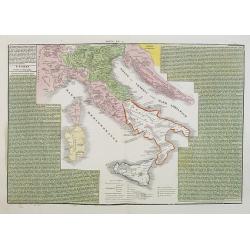
L'Italia ripartita a diversi dominii, in forza delli trattati di pace ottenuti dall' impero francese, conquiso al 1815.
A rare and detailed double-page map of Italy around the year 1815. The map is surrounded by an explanatory historical text about the country in a yellow background color....
Date: Venice, 1840
Selling price: ????
Please login to see price!
Sold in 2017
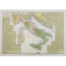
L'Italia dopo le prime guerre del secolo XVIII, eipartita dal vantato equilibrio europeo, sino al 1789.
A rare and detailed double-page map of Italy during the years 1748 - 1795. The map is surrounded by an explanatory historical text about the country in a yellow backgroun...
Date: Venice, 1840
Selling price: ????
Please login to see price!
Sold in 2023
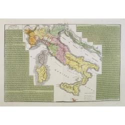
L'Italia suddivisa ne'varii stati che la dominavano circa al 1700.
A rare and detailed double-page map of Italy around the year 1700. The map is surrounded by an explanatory historical text about the country in a green background color.F...
Date: Venice, 1840
Selling price: ????
Please login to see price!
Sold in 2017
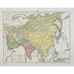
L\'Asia . . .
A rare and detailed double-page map of Asia. According to the title cartouche, prepared by A de La Sage for l\'Atlante Storico, Letterario, Biografico, Archeologico. . . ...
Date: Venice, 1840
Selling price: ????
Please login to see price!
Sold in 2009
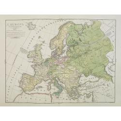
L'Europa colle politiche divisioni nel 1827.
A rare and detailed double-page map of Europe. From l'Atlante Storico, Letterario, Biografico, Archeologico. . . with attributions by Giambatista Albrizzi.Upper left a k...
Date: Venice, 1840
Selling price: ????
Please login to see price!
Sold in 2009
Regno Lombardo-Veneto parte dell' Impero Austriaco.
A rare and detailed double-page map of Northern Italy. From l'Atlante Storico, Letterario, Biografico, Archeologico. . . with attributions by Giambatista Albrizzi.Engrav...
Date: Venice, 1840
Selling price: ????
Please login to see price!
Sold in 2009
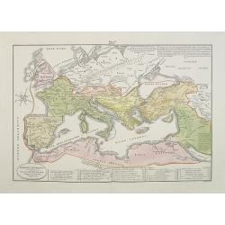
Impero Romano . . .
A rare double-page map of the Roman Empire. From l'Atlante Storico, Letterario, Biografico, Archeologico. . . with attributions by Giambatista Albrizzi.Lower part a key....
Date: Venice, 1840
Selling price: ????
Please login to see price!
Sold in 2009
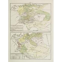
La Germania Legislativa . . . / La Germania ne' suoi principali dominii . . .
Two rare maps of Germany: Top map: 160 x 235mm. Bottom map: 155 x 230mm.Prepared by Las Casas for l'Atlante Storico, Letterario, Biografico, Archeologico. . . with attri...
Date: Venice, 1840
Selling price: ????
Please login to see price!
Sold in 2022
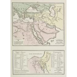
Divisione della Terra . . . / Viaggio . . .
Two rare maps on one sheet. Top map of the Arabian peninsula, Turkey, Europe and part of Africa (200 x 240mm.), and the other of the Holy Land and Egypt (113 x 230mm.)Fro...
Date: Venice, 1840
Selling price: ????
Please login to see price!
Sold in 2009

Château de Rustephan. (Bretagne).
A view of the ruin of Rustephan Castle. Made "after nature" by Serda in 1837.
Date: Paris, ca. 1840
Selling price: ????
Please login to see price!
Sold in 2009

Eglise et cimetière a St. Marc. (Bretagne).
A view of the cemetery of St. Marc in Bretagne. Made "after nature" by Serda in 1837. Lithographed by Vulleneuve.
Date: Paris, ca. 1840
Selling price: ????
Please login to see price!
Sold in 2009

Capitulation de Cornwallis. Washington, Rochambeau, Lafayette - 19 Septembre 1781.
The plate, engraved by Delignon, shows a full-lentg figure of Washington in uniform, in company with Lafayette, Rochambeau and his officers, in the act of receiving the s...
Date: Paris, c.1840
Selling price: ????
Please login to see price!
Sold in 2009
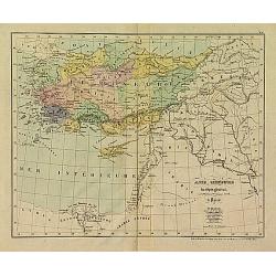
Carte du pays occupé par les Kirghiz-Kazaks ou Kirghiz-Kaïssaks. . .
Map representing Kazakhstan, Uzbekistan, Turkmenistan, northern part of Afghanistan, with the Caspian Sea in the west.
Date: Paris, 1840
Selling price: ????
Please login to see price!
Sold in 2011
Asie Mineure..
Uncommon map of Turkey, Cyprus and Palestine. Lithography in very delicate hand colors with ,Route de Xenophon, marked in red.
Date: Paris, 1840
Selling price: ????
Please login to see price!
Sold

Le Perroquet gris / Le Perroquet vert.
Decorative lithography from a later edition of ,Histoire naturelle, by Georges-Louis Leclerc, comte de BUFFON, this great naturalist (1707-88) spent the greater part of h...
Date: Paris, 1840
Selling price: ????
Please login to see price!
Sold in 2017
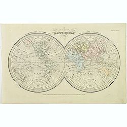
Mappe-Monde.
Finely engraved double hemisphere world map prepared by A.H.Dufour and engraved by Giraldon-Bovinet. Published by Jules Renouard in his uncommon atlas "Le globe Atla...
Date: Paris, Jules Renouard, ca.1840
Selling price: ????
Please login to see price!
Sold in 2013
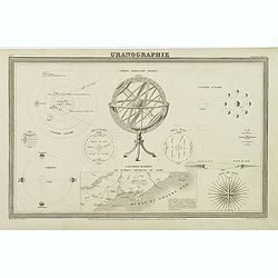
Uranographie.
Finely engraved Uranography plate with an armillary sphere in the center. Uranography is the branch of astronomy concerned with mapping the stars, galaxies, or other cele...
Date: Paris, Jules Renouard, ca.1840
Selling price: ????
Please login to see price!
Sold in 2011
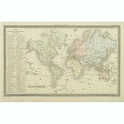
Mappe-Monde.
Finely engraved world map in Mercator projection prepared by A.H.Dufour and engraved by Giraldon-Bovinet. Published by Jules Renouard in his uncommon atlas "Le globe...
Date: Paris, Jules Renouard, ca.1840
Selling price: ????
Please login to see price!
Sold in 2012
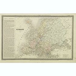
Europe.
Finely engraved map of Europe prepared by A.H.Dufour and engraved by Giraldon-Bovinet. Published by Jules Renouard in his uncommon atlas "Le globe Atlas classique Un...
Date: Paris, Jules Renouard, ca.1840
Selling price: ????
Please login to see price!
Sold in 2015
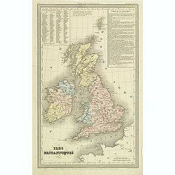
Iles Britanniques.
Finely engraved map of British Isles prepared by A.H.Dufour and engraved by Giraldon-Bovinet. Published by Jules Renouard in his uncommon atlas "Le globe Atlas class...
Date: Paris, Jules Renouard, ca.1840
Selling price: ????
Please login to see price!
Sold in 2011
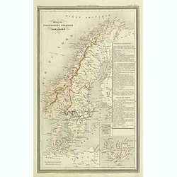
Monarchie Norvegieno Suedoise et Danemark.
Finely engraved map of Scandinavia, including Norway, Sweden, Denmark with insets of Iceland and Faroe Islands, prepared by A.H.Dufour and engraved by Giraldon-Bovinet. P...
Date: Paris, Jules Renouard, ca.1840
Selling price: ????
Please login to see price!
Sold in 2012
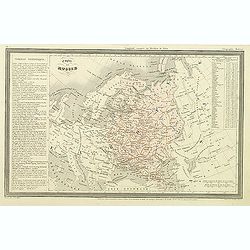
Empire de Russie.
Finely engraved map of Russia prepared by A.H.Dufour and engraved by Giraldon-Bovinet. Published by Jules Renouard in his uncommon atlas "Le globe Atlas classique Un...
Date: Paris, Jules Renouard, ca.1840
Selling price: ????
Please login to see price!
Sold in 2012
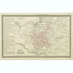
Royaume de Pologne.
Finely engraved map of Poland prepared by A.H.Dufour and engraved by Giraldon-Bovinet. Published by Jules Renouard in his uncommon atlas "Le globe Atlas classique Un...
Date: Paris, Jules Renouard, ca.1840
Selling price: ????
Please login to see price!
Sold in 2011
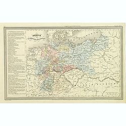
Prusse et confédération Germanique.
Finely engraved map of Prussia and part of Poland prepared by A.H.Dufour and engraved by Giraldon-Bovinet. Published by Jules Renouard in his uncommon atlas "Le glob...
Date: Paris, Jules Renouard, ca.1840
Selling price: ????
Please login to see price!
Sold in 2011
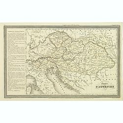
Empire d'Autriche.
Finely engraved map of Austria prepared by A.H.Dufour and engraved by Giraldon-Bovinet. Published by Jules Renouard in his uncommon atlas "Le globe Atlas classique U...
Date: Paris, Jules Renouard, ca.1840
Selling price: ????
Please login to see price!
Sold in 2011
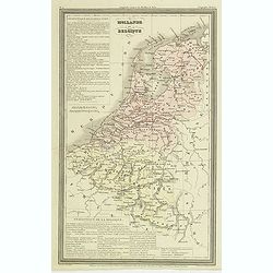
Hollande et Belgique.
Finely engraved map of the Netherland, Belgium and Luxemburg, prepared by A.H.Dufour and engraved by Giraldon-Bovinet. Published by Jules Renouard in his uncommon atlas &...
Date: Paris, Jules Renouard, ca.1840
Selling price: ????
Please login to see price!
Sold in 2011
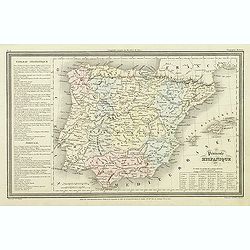
Péninsule hispanique.
Finely engraved map of Spain and Portugal, including Majorca, Menorca and Ibiza, prepared by A.H.Dufour and engraved by Giraldon-Bovinet. Published by Jules Renouard in h...
Date: Paris, Jules Renouard, ca.1840
Selling price: ????
Please login to see price!
Sold in 2018
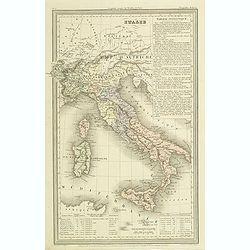
Italie.
Finely engraved map of Italy, including Sardinia and Corsica prepared by A.H.Dufour and engraved by Giraldon-Bovinet. Published by Jules Renouard in his uncommon atlas &q...
Date: Paris, Jules Renouard, ca.1840
Selling price: ????
Please login to see price!
Sold in 2012
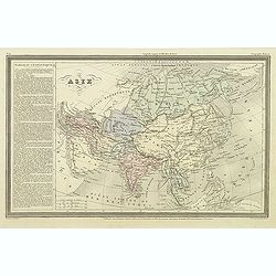
Asie.
Finely engraved map of Asia prepared by A.H.Dufour and engraved by Giraldon-Bovinet. The map is of interest for the use of East Sea, the sea between Korea and Japan, here...
Date: Paris, Jules Renouard, ca.1840
Selling price: ????
Please login to see price!
Sold in 2012
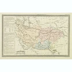
Perse, Kaboul et confédération des Beloutchi.
Finely engraved map of Persia, Iran, Iraq, etc. prepared by A.H.Dufour and engraved by Giraldon-Bovinet. Published by Jules Renouard in his uncommon atlas "Le globe ...
Date: Paris, Jules Renouard, ca.1840
Selling price: ????
Please login to see price!
Sold in 2023
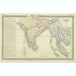
Inde.
Finely engraved map of India, Thailand, Malaysia, including Singapore prepared by A.H.Dufour and engraved by Giraldon-Bovinet. Published by Jules Renouard in his uncommon...
Date: Paris, Jules Renouard, ca.1840
Selling price: ????
Please login to see price!
Sold in 2015
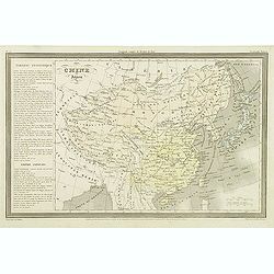
Chine et Japon.
Finely engraved map of China, Korea, Formosa and Tibet, prepared by A.H.Dufour and engraved by Giraldon-Bovinet. Published by Jules Renouard in his uncommon atlas "L...
Date: Paris, Jules Renouard, ca.1840
Selling price: ????
Please login to see price!
Sold in 2015
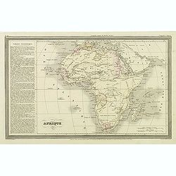
Afrique.
Finely engraved map of Africa prepared by A.H.Dufour and engraved by Giraldon-Bovinet. Published by Jules Renouard in his uncommon atlas "Le globe Atlas classique Un...
Date: Paris, Jules Renouard, ca.1840
Selling price: ????
Please login to see price!
Sold in 2011
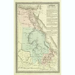
Egypte Nubie et Abyssinie.
Finely engraved map of Egypt prepared by A.H.Dufour and engraved by Giraldon-Bovinet. Published by Jules Renouard in his uncommon atlas "Le globe Atlas classique Uni...
Date: Paris, Jules Renouard, ca.1840
Selling price: ????
Please login to see price!
Sold in 2012
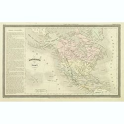
Amerique du nord.
The map depicts the short lived "Republic of Fredonia," a reference to the Fredonia Rebellion, the first attempt to create a separate independent Republic in Te...
Date: Paris, Jules Renouard, ca.1840
Selling price: ????
Please login to see price!
Sold in 2012
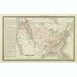
Etats-Unis.
Finely engraved map prepared by A.H.Dufour and engraved by Giraldon-Bovinet, shortly before Texas became part of the United States. After gaining independence from Spain ...
Date: Paris, Jules Renouard, ca.1840
Selling price: ????
Please login to see price!
Sold in 2012
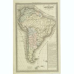
Amerique du sud.
Finely engraved map of South America, prepared by A.H.Dufour and engraved by Giraldon-Bovinet. Published by Jules Renouard in his uncommon atlas "Le globe Atlas clas...
Date: Paris, Jules Renouard, ca.1840
Selling price: ????
Please login to see price!
Sold