Browse Listings
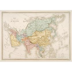
Carte de L'Asie.
Detailed map of Asia.From Malte-Brun's Atlas Géographie Universelle.."., revised by Jean Jacques Nicolas Huot.This very fine executed map has been printed...
Date: Paris 1837
Selling price: ????
Please login to see price!
Sold
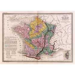
Carte physique et minéralogique de la France.
Thematical map of France with inset map of Corsica and Paris.From Malte-Brun's Atlas Géographie Universelle.."., revised by Jean Jacques Nicolas Huot.This...
Date: Paris 1837
Selling price: ????
Please login to see price!
Sold
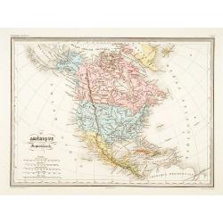
Amérique Septentrionale.
Fine map of North America.From Malte-Brun's Atlas Géographie Universelle.."., revised by Jean Jacques Nicolas Huot.This very fine executed map has been printed by F...
Date: Paris, 1837
Selling price: ????
Please login to see price!
Sold in 2011
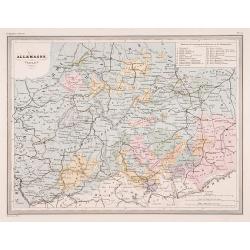
Allemagne centrale.
"Map of Germany.From Malte-Brun's Atlas Géographie Universelle..""., revised by Jean Jacques Nicolas Huot.This very fine executed map has been p...
Date: Paris 1837
Selling price: ????
Please login to see price!
Sold
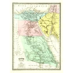
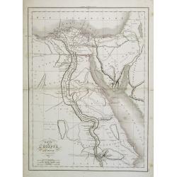
Egypte Ancienne.
Fine map of ancient Egypt.From Malte-Brun's Atlas Géographie Universelle.. ., revised by Jean Jacques Nicolas Huot.This very fine executed map has been printed by Fosset...
Date: Paris 1837
Selling price: ????
Please login to see price!
Sold
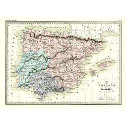
Éspagne Ancienne.
Detailed map of ancient Spain and Portugal.From Malte-Brun's Atlas Géographie Universelle.., revised by Jean Jacques Nicolas Huot.This very fine executed map has been pr...
Date: Paris 1837
Selling price: ????
Please login to see price!
Sold
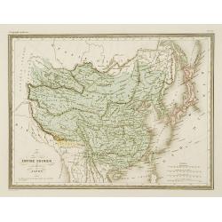
Empire Chinois et Japon.
Detailed map of China, Korea, Taiwan and Japan.From Malte-Brun's Atlas Géographie Universelle.., revised by Jean Jacques Nicolas Huot.This very fine executed map has bee...
Date: Paris 1837
Selling price: ????
Please login to see price!
Sold
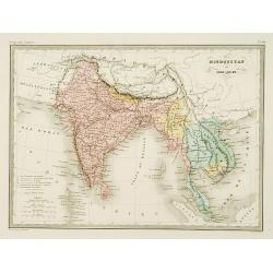
Hindoustan et Indo-Chine.
Detailed map of India, Pakistan, Thailand, Malaysia, Vietnam, etc.From Malte-Brun's Atlas Géographie Universelle..., revised by Jean Jacques Nicolas Huot.This very fine ...
Date: Paris 1837
Selling price: ????
Please login to see price!
Sold
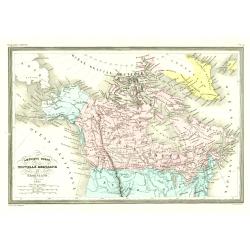
Amérique Ruse, Nouvelle Bretagne et Groenland.
Detailed map of Canada and Alaska.From Malte-Brun's Atlas Géographie Universelle.., revised by Jean Jacques Nicolas Huot.This very fine executed map has been printed by ...
Date: Paris 1837
Selling price: ????
Please login to see price!
Sold
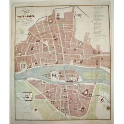
Plan de la Ville de Paris, sous Phillipe de Bel...
An uncommon, large scale, decorative early 19th century plan of Paris. The work was commissioned by architect Albert Lenoir. Important buildings are highlighted and stree...
Date: Paris, 1837
Selling price: ????
Please login to see price!
Sold
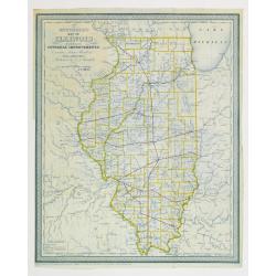
Mitchell's map of illinois exhibiting its internal improvements,
Detailed book illustration map of Illinois with railroads in red on crisp paper in blue print. Shows roads and stage roads. Very scarce map from Mitchell's Illinois in 18...
Date: Philadelphia 1837
Selling price: ????
Please login to see price!
Sold
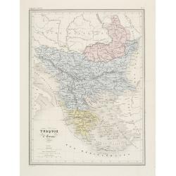
Turquie d' Europe. (Greece)
Detailed map of Greece.From Malte-Brun's Atlas Géographie Universelle.. ., revised by Jean Jacques Nicolas Huot.This very fine executed map has been printed by Fosset an...
Date: Paris, 1837
Selling price: ????
Please login to see price!
Sold in 2013
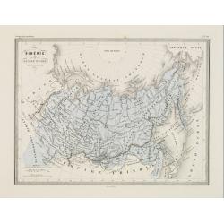
Sibérie ou Russie d'asie.
Fine map of the Siberia and Northern part of China.From Malte-Brun's Atlas Géographie Universelle.. ., revised by Jean Jacques Nicolas Huot.This very fine executed map h...
Date: Paris 1837
Selling price: ????
Please login to see price!
Sold
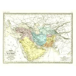
Carte de la Turquie d'asie, de la Perse. . .
Fine map of the Turkish Empire.From Malte-Brun's Atlas Géographie Universelle.., revised by Jean Jacques Nicolas Huot.This very fine executed map has been printed by Fos...
Date: Paris, 1837
Selling price: ????
Please login to see price!
Sold in 2016
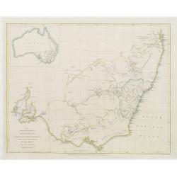
Map of the South East portion of Australia..
Prepared by Major Mitchell and published by J.Murray. Engraved by J.Arrowsmith.Map of New South Wales with in top left inset map of the complete continent.The maps of Aus...
Date: London 1837
Selling price: ????
Please login to see price!
Sold
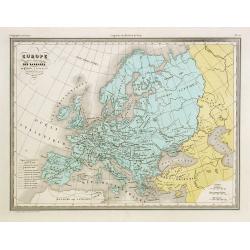
Europe aprés l'invasion des Barbares..
Ancient map of Europe in the 5th and 6th century.From Malte-Brun's Atlas G�ographie Universelle.., revised by Jean Jacques Nicolas Huot.This very fine executed map h...
Date: Paris 1837
Selling price: ????
Please login to see price!
Sold in 2008
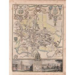
'CITY AND UNIVERSITY OF OXFORD'.
A highly detailed, finely engraved, hand colored plan of the University City of Oxford, embellished with the heraldic shields, arms of the Town, the University, and its c...
Date: London, 1837
Selling price: ????
Please login to see price!
Sold in 2019
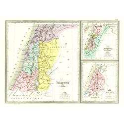
Palestine .. Romains/ .. David et Salomon./ Douze tribes
3 Maps on one sheet of Holy Land during Roman times, during David and Salomon and one divided into 12 tribes.From Malte-Brun's Atlas Géographie Universelle.., revised by...
Date: Paris, 1837
Selling price: ????
Please login to see price!
Sold
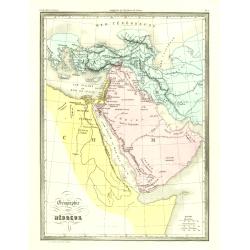
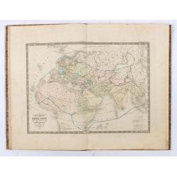
Géographie des Hébreux.
Fine map of the Arabian Peninsula, Egypt and the Near East.From Malte-Brun's Atlas Géographie Universelle.. ., revised by Jean Jacques Nicolas Huot.This very f...
Date: Paris, 1837
Selling price: ????
Please login to see price!
Sold in 2009
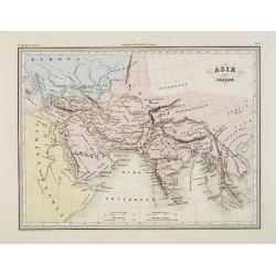
Asie ancienne.
Fine map of ancient Asia.From Malte-Brun's Atlas Géographie Universelle.., revised by Jean Jacques Nicolas Huot.This very fine executed map has been printed by...
Date: Paris, 1837
Selling price: ????
Please login to see price!
Sold in 2009
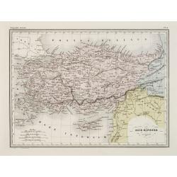
Asie mineure Ancienne.
Fine map of ancient Turkey with Cyprus.From Malte-Brun's Atlas Géographie Universelle.., revised by Jean Jacques Nicolas Huot.This very fine executed map has been printe...
Date: Paris, 1837
Selling price: ????
Please login to see price!
Sold
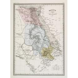
Égypte Nubie & Abyssinie.
Fine map of Egypt.From Malte-Brun's Atlas Géographie Universelle.., revised by Jean Jacques Nicolas Huot.This very fine executed map has been printed by Pierre Sarrazin ...
Date: Paris, 1837
Selling price: ????
Please login to see price!
Sold
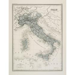
Italie.
Fine map of Italy.From Malte-Brun's Atlas Géographie Universelle.. ., revised by Jean Jacques Nicolas Huot.This very fine executed map has been printed by Fosset and was...
Date: Paris, 1837
Selling price: ????
Please login to see price!
Sold in 2011
![Carte de la Mer de Chine.. [Together with] Carte des Cotes orientales de Chine.. [Together with] Carte générale de la Mer des Indes..](/uploads/cache/24291-250x250.jpg)
Carte de la Mer de Chine.. [Together with] Carte des Cotes orientales de Chine.. [Together with] Carte générale de la Mer des Indes..
A set of 3 printed charts of the China Sea added in manuscripts the tracks of the French frigate "Cleopatre" under command of Adm. Cecille in the years 1846 - 1...
Date: Paris, 1838, 1842, 1837
Selling price: ????
Please login to see price!
Sold in 2009
![[untitled plan of Osaka]](/uploads/cache/99163-250x250.jpg)
[untitled plan of Osaka]
Rare Japanese colored woodcut printed map of Osaka. Very large size and scale, with excellent detail. Dated from the Tenpo era which was from 1830-44!It indicates the Osa...
Date: Japan, c. 1837
Selling price: ????
Please login to see price!
Sold in 2009
Carte de L'Egypte Ancienne par Delamarche.
Steel engraved map of ancient Egypt.
Date: Paris, 1837
Selling price: ????
Please login to see price!
Sold in 2016
![[untitled Atlas of Japan]](/uploads/cache/91044-250x250.jpg)
[untitled Atlas of Japan]
Very attractive early Japanese Atlas, containing 68 detailed woodblock maps/plans. Tempo 8 = 1837. The book measures 20x28cms when closed and has 76 pages. With excellen...
Date: Japan, Tempo 8 = 1837
Selling price: ????
Please login to see price!
Sold in 2009

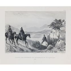
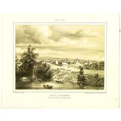
Pont de Santiago sur le Rio Mapocho.
Drawn by V. Adam and engraved by Benard and Frey. From Bougainville's "Journal de la navigation autour du globe de la fregate la Thetis et de la corvette l'Esperance...
Date: Paris, 1837
Selling price: ????
Please login to see price!
Sold in 2011
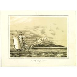
Guasos des environs de Valparaiso et de Santiago.
Drawn by V. Adam and engraved by Benard and Frey. From Bougainville's "Journal de la navigation autour du globe de la fregate la Thetis et de la corvette l'Esperance...
Date: Paris, 1837
Selling price: ????
Please login to see price!
Sold in 2010
![[Title page] Flora's dictionary by Mrs. E.W. Wirt of Virginia.](/uploads/cache/31045-250x250.jpg)
[Title page] Flora's dictionary by Mrs. E.W. Wirt of Virginia.
Charming title page from "Flora's dictionary by Mrs. E.W. Wirt of Virginia. Embellished by miss Ann Wish".Hand-colored lithographic plates after Ann Smith.The w...
Date: Baltimore, Fielding jnr, L.,1837
Selling price: ????
Please login to see price!
Sold in 2011

(Title page) Album venitien composé de douze vues. . .
Beautiful title page from "Album venitien composé de douze vues" with in center Venice's famous Bridge of Sighs, which was designed by Antonio Contino and was ...
Date: Venice, J. Kier, 1837
Selling price: ????
Please login to see price!
Sold in 2019
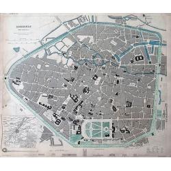
Brussels (Bruxelles)
Highly detailed town plan of Brussels, with profile views of 8 principal buildings and a smaller map of the environs of Brussels. With street names, buildings, parks, etc...
Date: London, 1837
Selling price: ????
Please login to see price!
Sold in 2011
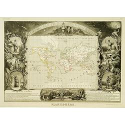
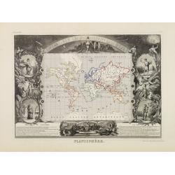
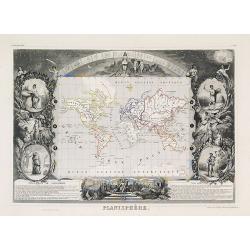
Planisphére.
One of the last decorative maps of the area. In side panels representations of the four seasons.From his Atlas Universel Illustré.
Date: Paris 1838
Selling price: ????
Please login to see price!
Sold
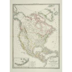
Carte de l'Amérique Septentrionale ..
Prepared by Alexandre Emile Lapie, a Colonel de l'Etat Major and first geographer to the King. Published by P.C.Lehuby, Rue de Seine 48, Paris. Engraved by Tardieu. Givin...
Date: Paris 1838
Selling price: ????
Please login to see price!
Sold
Planisphére.
One of the last decorative maps of the area. In side panels representations of the four seasons. A very popular and decorative 19th century map. From his Atlas Universel ...
Date: Paris 1838
Selling price: ????
Please login to see price!
Sold
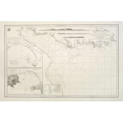
Carta esférica del Rio de la Plata...
Large nautical chart.
Date: Madrid 1812-1838
Selling price: ????
Please login to see price!
Sold
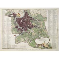
Pianta topografica della citta di Roma.
Uncommon and decorative plan of Rome. With a numbered key. 1-264. Engraved by Marco di Pietro.
Date: Florence 1838
Selling price: ????
Please login to see price!
Sold
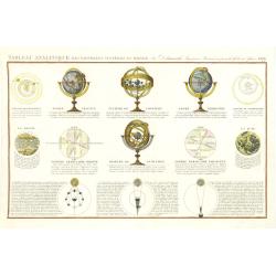
Tableau Analitique des différens systemes du monde. . .
The illustrated globes and spheres are similar to the ones sold by Delamarche. Also depicting Sun, Moon and several positions. Engraved by Pelicier.Uncommon, with the dat...
Date: Paris, 1838
Selling price: ????
Please login to see price!
Sold in 2011
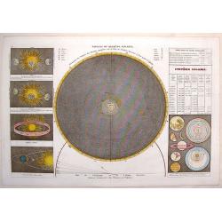
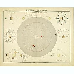
Tableau du Systeme Solaire.
An interesting celestial chart showing the movement of the planets including a comet's trajectory within its solar system.
Date: Paris, 1838
Selling price: ????
Please login to see price!
Sold in 2013
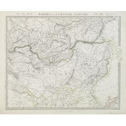
Siberia and Chinese Tartary.
Steel engraved map of Mongolia, Manchuria, Siberia, Korea, Sakhalin and part of Japan.Published by the Society for the Diffusion of Useful Knowledge, 59 Lincolns Inn Fiel...
Date: London, SDUK, 1838
Selling price: ????
Please login to see price!
Sold in 2014
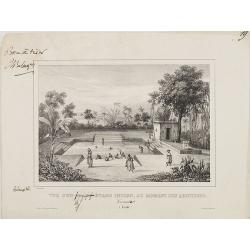
Vue d'un grand étang Indien, au moment des ablutions Carnate. (Inde)
After a drawing by Charles Bélanger. Charles Bélanger (1805-1881), French naturalist and explorer in Asia and the East Indies. Lithography taken most probably from 7 vo...
Date: Paris, ca 1834-1838
Selling price: ????
Please login to see price!
Sold in 2013
Planisphère.
One of the last decorative maps of the area. In side panels representations of the four seasons. From his "Atlas Universel Illustré".Very fine.
Date: Paris, 1838
Selling price: ????
Please login to see price!
Sold in 2009

Vue de la Pagode de Shoe Dagon. Prise des environs de Rangoun (Pégou.).
View different pagodas after a drawing by Paquet and Charles Bélanger. Charles Bélanger (1805-1881), French naturalist and explorer in Asia and the East Indies. Lithogr...
Date: Paris, ca 1834-1838
Selling price: ????
Please login to see price!
Sold in 2009
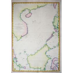
Carte de la mer de Chine...
Highly decorative and scarce large-scale seachart of the South China Sea. Extending from China to Borneo with the Philippines and surroundings countries and islands! Ext...
Date: Paris, 1838
Selling price: ????
Please login to see price!
Sold in 2011
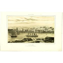
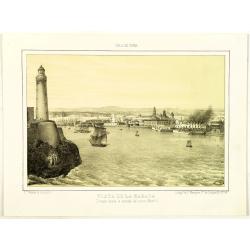
Habana. 2a Vista tomada desde Casa-Blanca.
Decorative view of Havana harbor, by Frederico Mialhe (1810-1881), with his signature on stone lower right. Lithographed by L. Marquier Ce de Lamparillo No. 96. From the ...
Date: Havana, 1838
Selling price: ????
Please login to see price!
Sold in 2010
Habana. 2a Vista tomada desde Casa-Blanca.
Decorative view of Havana harbor, by Frederico Mialhe (1810-1881), with his signature on stone lower right. Lithographed by L. Marquier Ce de Lamparillo No. 96. From the ...
Date: Havana, 1838
Selling price: ????
Please login to see price!
Sold in 2010
Habana. 2a Vista tomada desde Casa-Blanca.
Decorative view of Havana harbor, by Frederico Mialhe (1810-1881), with his signature on stone lower right. Lithographed by L. Marquier Ce de Lamparillo No. 96. From the ...
Date: Havana, 1838
Selling price: ????
Please login to see price!
Sold in 2010
Habana. 2a Vista tomada desde Casa-Blanca.
Decorative view of Havana harbor, by Frederico Mialhe (1810-1881), with his signature on stone lower right. Lithographed by L. Marquier Ce de Lamparillo No. 96. From the ...
Date: Havana, 1838
Selling price: ????
Please login to see price!
Sold in 2010
Habana. 2a Vista tomada desde Casa-Blanca.
Decorative view of Havana harbor, by Frederico Mialhe (1810-1881), with his signature on stone lower right. Lithographed by L. Marquier Ce de Lamparillo No. 96. From the ...
Date: Havana, 1838
Selling price: ????
Please login to see price!
Sold in 2010

Habana. 2a Vista tomada desde Casa-Blanca.
Decorative view of Havana harbor, by Frederico Mialhe (1810-1881), with his signature on stone lower right. Lithographed by L. Marquier Ce de Lamparillo No. 96. From the ...
Date: Havana, 1838
Selling price: ????
Please login to see price!
Sold in 2010
Carte des routes de poste de France dressée par Tardieu Graveur 1838.
This post road maps map of France is showing incredible detail of the postal roads, stations (or "stages"), and the distances from town to town. Lower left an i...
Date: Paris, 1838
Selling price: ????
Please login to see price!
Sold
Carte Generale du Monde Connu des Anciens. . .
A map of the known world in ancient times, from the Canary Islands in the west, Estonia in the north, Thailand in the east, and Somalia in the south. Relief is shown by h...
Date: Paris, 1838
Selling price: ????
Please login to see price!
Sold in 2021
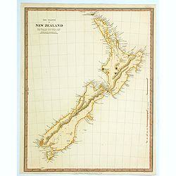
The Islands of New Zealand.
This is a map of New Zealand produced by the Society for the Diffusion of Useful Knowledge (S.D.U.K.). It covers the entire island country from Cape Reinga (C. Maria Van ...
Date: London, 1838
Selling price: ????
Please login to see price!
Sold in 2021
Atlas historique ancien et moderne renfermant toutes les cartes anciennes, du Moyen Age, et Modernes....
This comprehensive atlas includes 33 maps of the known World as described by sources from Antiquity, the Middle Ages, the Rennaissance and Age of Discovery, the Early Mo...
Date: Paris, chez l'Auteur, 1838
Selling price: ????
Please login to see price!
Sold in 2024
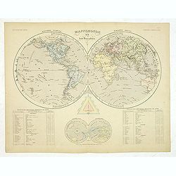
Mappemonde en deux Hemisphères.
Double hemisphere world map with two polar insets. Prepared by J. Andriveau-Goujon and included in his "Atlas Elémentaire simplifié". Prime meridian to Paris.
Date: Paris, E.Soulier,1838
Selling price: ????
Please login to see price!
Sold in 2012
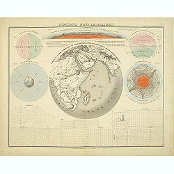
Notions preleminaires.
Shows map projections, symbols, longitude, latitude, and molten core of the earth. The graphic on the mapis most unusual. Prepared by J. Andriveau-Goujon and included in ...
Date: Paris, E.Soulier,1838
Selling price: ????
Please login to see price!
Sold in 2012
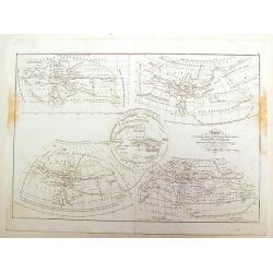
Systeme Planetaire.
Several diagrams showing planetary relationships. Prepared by J. Andriveau-Goujon and included in his "Atlas Elémentaire simplifié".
Date: Paris, E.Soulier, 1838
Selling price: ????
Please login to see price!
Sold in 2012
Carte de la Geographie Primative des Grecs d'apres Homere et Hesiode
This map of primitive geographie by Delamarche was some of the bet quality for the time and depicts how the Greeks saw their world. Charles Francois Delamarche (1740-18...
Date: Paris, 1838
Selling price: ????
Please login to see price!
Sold in 2013

3 Portraits of Christopher Columbus, Queen Isabella and King Ferdinand.
Three hand-colored, steel engravings of the three individuals responsible for discovering America - Christopher Columbus and his investment bankers, Isabella and Ferdinan...
Date: London, 1838
Selling price: ????
Please login to see price!
Sold in 2013

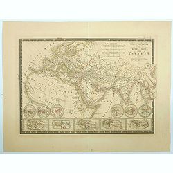
Carte generale de L'Asia.
Detailed steel engraving of Dufour's map of Asia dated 1838. Adolphe Hippolyte Dufour (1798 - 1865), also known as Auguste-Henri Dufour, was a Paris based map and atlas...
Date: Paris, 1838
Selling price: ????
Please login to see price!
Sold in 2013
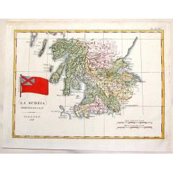
La Scozia Meridionale.
Striking Marmocco map with his signature map (Southern Scotland) added. Francesco Costantino Marmocchi (1805 - 1858 ) was an Italian geographer . His other writings de...
Date: Florence, 1838
Selling price: ????
Please login to see price!
Sold in 2014
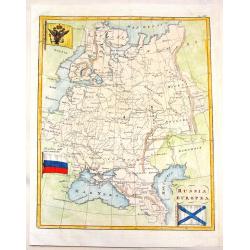
Russia Europa.
Pleasing map of Russia with three pertinant flags. Includes Russian flag as well as flags of war and mercantile marine. The flags covers Russia, poland, Lithuania, Estoni...
Date: Florence, 1838
Selling price: ????
Please login to see price!
Sold in 2013
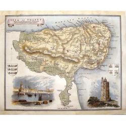
Isle of Thanet.
Decorative map oF the Island of Thanet, Kent with two views and 2 coats of arms. This is a map from "ENGLISH COUNTIES DELINEATED" by Thomas Moule who combined a...
Date: London, 1838
Selling price: ????
Please login to see price!
Sold in 2014
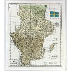
La Svezia e la Gotia.
A fine map of Sweden by Francesco Constantino Marmocchi. It is from the atlas "Atlante di Geogrfia Universale" published in Florence in 1838. The map features a...
Date: Florence, 1838
Selling price: ????
Please login to see price!
Sold in 2016
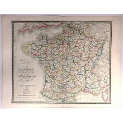
The Kingdom of France describing the New Limits according to the Treaty of Paris.
A large, beautifully detailed, and colorful map of France divided into 86 departments, with Corsica as an inset. No cartouche but very decorative calligraphy in the title...
Date: London, 1838
Selling price: ????
Please login to see price!
Sold in 2016
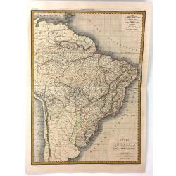
Carte du Bresil
A fine, detailed map of Brazil from Columbia to the Atlantic Ocean. The map also includes parts of the neighbouring countries of Chile, Peru and the Caribbean. Engraved b...
Date: Paris, 1838
Selling price: ????
Please login to see price!
Sold in 2016
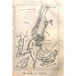
Plan der Bai von New=York.
Unusual map of early New York City. Only southern Manhattan is shown populated, with a few buildings in Brooklyn. Long Island and Staten Island appear almost uninhabited....
Date: Stuttgart, 1838
Selling price: ????
Please login to see price!
Sold in 2017
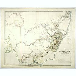
The South Eastern portion of Australia compiled from the Colonial surveys, and from details furnished by exploratory expeditions by John Arrowsmith.
Early 1838 state of this important map of the South Eastern portion of Australia. By 1839 John Arrowsmith had produced one of his replacement maps, "The South Easter...
Date: London, 1838
Selling price: ????
Please login to see price!
Sold in 2017
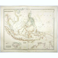
Asiatic Archipelago.
Map of the Asiatic Archipelago with very good detail on the Philippines. In the lower-left corner inset of Singapore Island. This map by the nephew of Aaron Arrowsmith fi...
Date: London, 1838
Selling price: ????
Please login to see price!
Sold in 2017
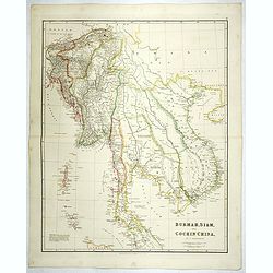
Burmah, Siam, and Cochin China.
Large-scale map of Burma, Siam and Cochin China with the current political divisions in the region. This map by the nephew of Aaron Arrowsmith first appeared in 1832 and ...
Date: London, 1838
Selling price: ????
Please login to see price!
Sold in 2018
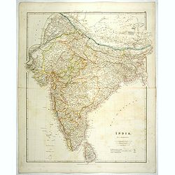
India.
Detailed map of India and Ceylon. This map by the nephew of Aaron Arrowsmith first appeared in 1832 and was reissued several times. The present issue appeared in Arrowsmi...
Date: London, 1838
Selling price: ????
Please login to see price!
Sold
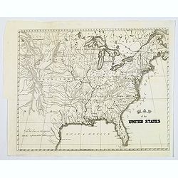
Map of the United States.
General map of the United States, dated around 1838 and shows Texas. Some place names, but mostly rivers and tributaries, lakes, territories mountains and some Indian tri...
Date: America, 1838
Selling price: ????
Please login to see price!
Sold in 2017
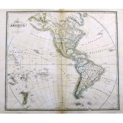
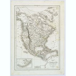
Map of America.
A large map of the Americas and the Pacific. With many interesting details, such as Russian Possessions in Alaska. Mexico seems to extend well into today's California, Ar...
Date: London, 1838
Selling price: ????
Please login to see price!
Sold in 2017
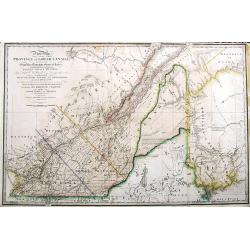
A New Map of the province of Lower Canada, describing all the Signeuries, Townships, Grants of Land, &c. . .
A large and important map of lower Canada, illustrating the land grants on either side of the St. Lawrence River. The disputed boundary line with the United States (with ...
Date: London, 1838
Selling price: ????
Please login to see price!
Sold in 2017
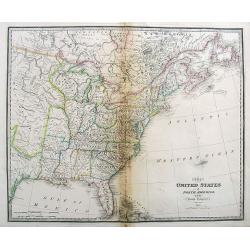
The United States of North America, with the British Territories.
A highly detailed map of the United States, extending from Missouri and Texas to New Found Land and the Bahamas.With some early names of regions, and several interesting ...
Date: London, 1838
Selling price: ????
Please login to see price!
Sold in 2017
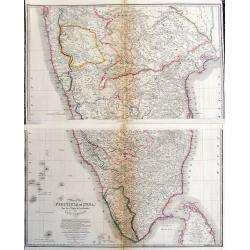
Map of the Peninsula of India, from the 19th Degree of North Latitude to Cape Comorin.
Large and detailed map of Southern India from Bomba/Mumbai and Aurangabad, until a part of of Sri Lanka/Ceylon. Original outline color indicated the British Possessions, ...
Date: London, 1838
Selling price: ????
Please login to see price!
Sold in 2017
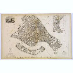
Venice.
A lovely steel engraved plan of Venice by the Society for the Diffusion of Useful Knowledge (SDUK). This English philanthropic enterprise was entirely devoted to the spre...
Date: London, 1838
Selling price: ????
Please login to see price!
Sold in 2018
Carte de l'Amerique Septentrionale.
French map of North America showing Oregon Territory extending north into British Columbia in Canada, Missouri Territory extends from the shores of Lake Michigan across t...
Date: Paris, 1838
Selling price: ????
Please login to see price!
Sold in 2017

Carte Generale de L'Asie.
A nice general map of the continent of Asia by Brue, from his Atlas Universel.Lots of map detail, a set of ten mileage scales, and a color key as to which countries belon...
Date: Paris, ca. 1838
Selling price: ????
Please login to see price!
Sold in 2017
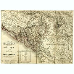
Carte du pays de Montenegro dressée d'après les opérations géodétiques . . .
A rare map of Montenegro, prepared by Mr. le Comte Fedor de Karacsay (1787-1859) and engraved by Pietro Allodi. The title is in Russian, Arabic, and French.In the lower-l...
Date: Vienna, ca. 1838
Selling price: ????
Please login to see price!
Sold in 2018