Browse Listings
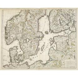
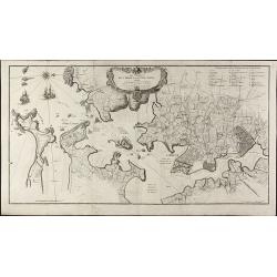
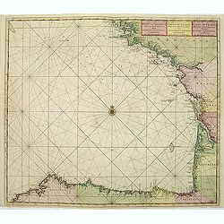
Mer Baltique - Golfe de Bothnie.
The map is centered on the Baltic Sea, including Denmark, Finland, a part of Poland, and southern parts of Norway and Sweden. Engraved by Liébaux le fils.
Date: Paris, 1750
Selling price: ????
Please login to see price!
Sold in 2009
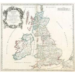
Britannicae, Insulae in quibus Albion sen Britannia Major, ...
British Isles by de Vaugondy.
Date: Paris, 1750
Selling price: ????
Please login to see price!
Sold in 2009
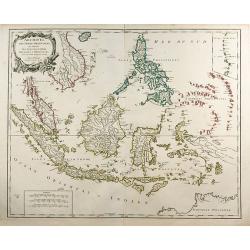
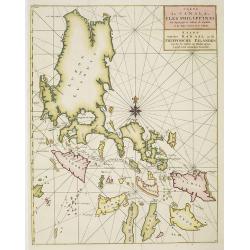
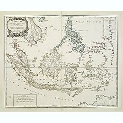
Archipel Des Indes Orientales, qui comprend Les Isles De La Sonde ... Philippines ...
An attractive and detailed view of the Indonesian islands in large format. Decorative title cartouche.
Date: Paris, 1750
Selling price: ????
Please login to see price!
Sold in 2009
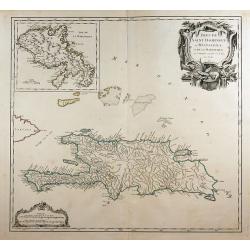
Isles de Saint Domingue ou Hispaniola, ...
A large map of Santo Domingo, with an inset showing the island of Martinique.
Date: Paris, 1750
Selling price: ????
Please login to see price!
Sold in 2011

Lilio Narcissus Hemerocalli disfacie.
Copper engraving. Issue with the text on verso, handcolored very skillfully at a later date.Plate 14 published in the Hortus Eystettensis . Without doubt one of the great...
Date: Eichstätt ca. 1713-1750
Selling price: ????
Please login to see price!
Sold in 2009
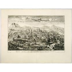
Jerusalem comme elle est a present.
A very decorative and extremely rare of Jerusalem, including a numbered (1-36) key in lower part. Published by Jacques Chéreau, (1688 - 1776). Engraved by Aveline and f...
Date: Paris, ca.1750
Selling price: ????
Please login to see price!
Sold in 2013
Florence. Florence Ville d'Tialie, capitale de Toscane. . .
A very decorative and extremely rare town-view of Florence, in Tuscany. Including a 4-line text in lower part. Published by Jacques Chéreau, (1688 - 1776). Engraved by A...
Date: Paris, ca.1750
Selling price: ????
Please login to see price!
Sold in 2016
Genes. Ville Capitale de la Republique de meme nom seituée sur la mer méditerranée en Italie.
A very decorative and extremely rare of Genoa, including a numbered key ( 1-30 ) in lower part. Published by Jacques Chéreau, (1688 - 1776). Engraved by Aveline and fir...
Date: Paris, ca.1750
Selling price: ????
Please login to see price!
Sold in 2012
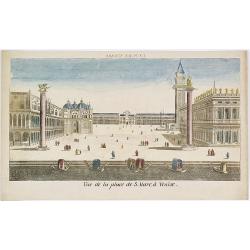
Vue de la Place de S.Marc à Venise.
Showing the St.Marco Square in Venice. Mondhard was a well-known publisher of optical prints, established in rue St.Martin in Paris. In the eighteenth and nineteenth cent...
Date: Paris, ca. 1750
Selling price: ????
Please login to see price!
Sold in 2009
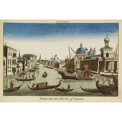
Venise vue du côté du g(rann)d canal.
Showing the Grand Canal in Venice. Likely published by Mondhard, a well-known publisher of optical prints, established in rue St.Martin in Paris. In the eighteenth and ni...
Date: Paris, ca. 1750
Selling price: ????
Please login to see price!
Sold in 2009
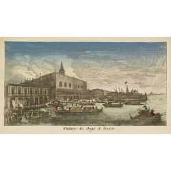
Palais du Doge à Venise.
Showing the Doge's Palace in Venice. Likely published by Mondhard, who was a well-known publisher of optical prints, established in rue St.Martin in Paris. In the eightee...
Date: Paris, ca. 1750
Selling price: ????
Please login to see price!
Sold in 2012
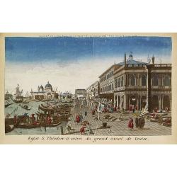
Eglise S.Théodore et entrée du grand canal de Venise.
Showing the entrance of the Grand Canal in Venice. Likely published by Mondhard, who was a well-known publisher of optical prints, established in rue St.Martin in Paris. ...
Date: Paris, ca. 1750
Selling price: ????
Please login to see price!
Sold in 2013
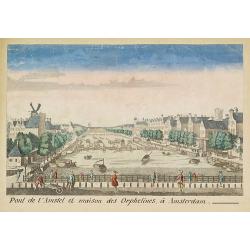
Pont de l'Amstel et maison des orphelines à Amsterdam.
Showing the Amstel bridge in Amsterdam. Likely published by Mondhard, who was a well-known publisher of optical prints, established in rue St.Martin in Paris. In the eigh...
Date: Paris, ca. 1750
Selling price: ????
Please login to see price!
Sold in 2011
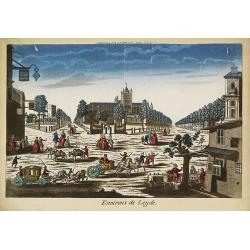
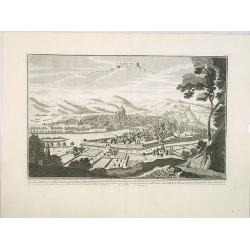
Environs de Leijde. (Vue des environs de Leyden)
Showing the market square in Leiden. J. Chereau was a publisher of optical prints, established in Paris, rue St.Jacques.In the eighteenth and nineteenth centuries there w...
Date: Paris, ca. 1750
Selling price: ????
Please login to see price!
Sold in 2012
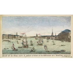
Bords de la Neva entre le palais d'hiver et les bâtiments de l'Acad.ie des Sciences à S.Pétersbourg.
Showing the Neva with the Winter Palace in St. Peterburg. J. Chereau was a publisher of optical prints, established in Paris, rue St.Jacques.In the eighteenth and ninetee...
Date: Paris, ca. 1750
Selling price: ????
Please login to see price!
Sold in 2012
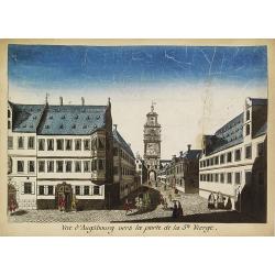
Vue d'Augsbourg vers la porte de la St. Vierge.
Showing a lively scene in 18th century Augsburg. J. Chereau was a publisher of optical prints, established in Paris, rue St.Jacques.In the eighteenth and nineteenth centu...
Date: Paris, ca. 1750
Selling price: ????
Please login to see price!
Sold in 2015

Intérieur de l'Eglise St.Marc à Venise.
Showing the interior of Saint Mark's Basilica in Venice. J. Chereau was a publisher of optical prints, established in Paris, rue St.Jacques.In the eighteenth and nineteen...
Date: Paris, ca. 1750
Selling price: ????
Please login to see price!
Sold in 2013
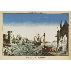
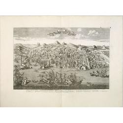
Port de Constantinople.
Showing a fanciful presentation of the harbor of Constantinople (Istanbul). J. Chereau was a publisher of optical prints, established in Paris, rue St.Jacques.In the eigh...
Date: Paris, ca. 1750
Selling price: ????
Please login to see price!
Sold in 2009
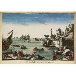
Ile de Malte, du côté du fort.
Showing to the right part of Fort St. Elmo at Valletta, with a lively foreground and a sea battle in the bay. The mirror-image title reads "Vue de Malthe du côté d...
Date: Paris, ca. 1750
Selling price: ????
Please login to see price!
Sold in 2009
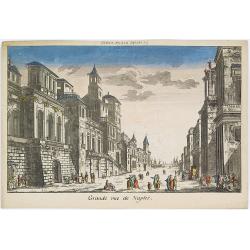
Grande rue de Naples.
Showing a street scene in Naples. J. Chereau was a publisher of optical prints, established in Paris, rue St.Jacques.In the eighteenth and nineteenth centuries there were...
Date: Paris, ca. 1750
Selling price: ????
Please login to see price!
Sold in 2016

Péristijle d'un palais de S. Pétersbourg.
Showing an arcade at the Royal Palace of Saint Petersburg. J. Chereau was a publisher of optical prints, established in Paris, rue St.Jacques.In the eighteenth and ninete...
Date: Paris, ca. 1750
Selling price: ????
Please login to see price!
Sold in 2018
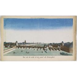
Vue de la ville et du pont de Francfort.
Showing the Medieval bridge over the river Main at Frankfurt am Main. J. Chereau was a publisher of optical prints, established in Paris, rue St.Jacques.In the eighteenth...
Date: Paris, ca. 1750
Selling price: ????
Please login to see price!
Sold in 2010
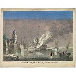
Vaisseau en feu dans le port de Messine.
Showing a fanciful depiction of the harbor of Messina on the island of Sicily and a burning vessel. J. Chereau was a publisher of optical prints, established in Paris, ru...
Date: Paris, ca. 1750
Selling price: ????
Please login to see price!
Sold in 2010
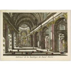
Intérieur de la Basilique de Saint Pierre.
Showing the Papal Basilica of Saint Peter, officially known in Italian as the Basilica Papale di San Pietro in Vaticano in Rome. J. Chereau was a publisher of optical pri...
Date: Paris, ca. 1750
Selling price: ????
Please login to see price!
Sold in 2013
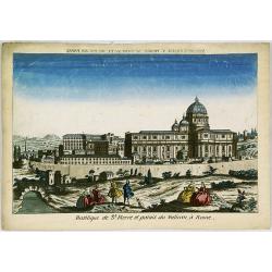
Basilique de St.Pierre et Palais du Vatican à Rome.
Showing the Papal Basilica of Saint Peter, and the Papal Palace in Vatican in Rome. J. Chereau was a publisher of optical prints, established in Paris, rue St.Jacques.In ...
Date: Paris, ca. 1750
Selling price: ????
Please login to see price!
Sold in 2013
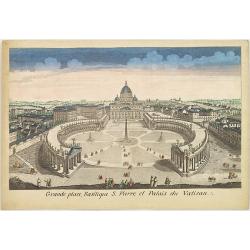
Grande place, Basilique S. Pierre et Palais du Vatican.
Showing the Papal Basilica of Saint Peter, and its square in the Vatican in Rome. J. Chereau was a publisher of optical prints, established in Paris, rue St.Jacques.In th...
Date: Paris, ca. 1750
Selling price: ????
Please login to see price!
Sold in 2013
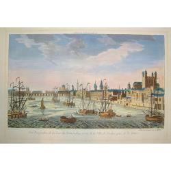
Vue Perspective...Ville de Londres prise de la Temise
A "vue optique" view of London on the River Thames. Major monuments are depicted, including the Tower of London, St. James and Westminster Bridge. Numerous mari...
Date: Paris, ca. 1750
Selling price: ????
Please login to see price!
Sold in 2010
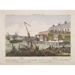
Vuë de Salem. (reversed) Salem - eine stadt in Engelländischen America, in der Grafschafft Essex, ... Salem - une ville de l'Amerique Angloise dans le Comte d'Essex, ... / gravé par Balth. Frederic Leizelt..
A so-called optical print. A lively and harbor scene of Salem, Massachusetts, with many people loading a vessel. Engraved by Balthazar Frederic Leizelt.This view is said...
Date: Augsburg, c. 1750
Selling price: ????
Please login to see price!
Sold
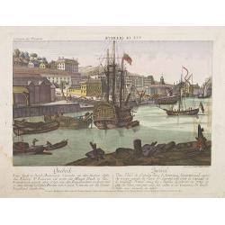
Quebeck.
A so-called optical print showing a decorative imaginary of Québec seen from the harbour, with a large vessel in the foreground. Engraved by Balthasar Frederic Leizelt....
Date: Augsburg, 1750
Selling price: ????
Please login to see price!
Sold in 2016
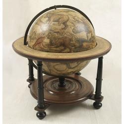
Celestial globe 15 inch, only 3 other copys known.
Title below Cetus in a cartouche : Uranographia Caelum omne hic Complectens, Illa pro ut aucta et ad annum 1750 Completum MAGNO ab HEVELIO correcta est: ita, ejus ex Prot...
Date: Amsterdam, after 1750
Selling price: ????
Please login to see price!
Sold
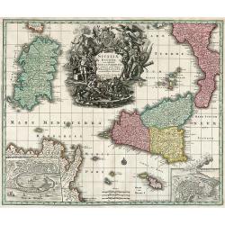
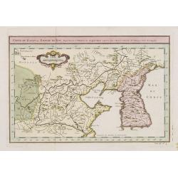
Siciliae Regnum cum adjacente Insula Sardinia et maxima parte Regni Neapolitani.
Map of Sicily, Sardinia, Malta and parts of Corsica, South Italy and North Africa. Inset map of Messina and Cartana.
Date: Augsburg, 1750
Selling price: ????
Please login to see price!
Sold in 2010
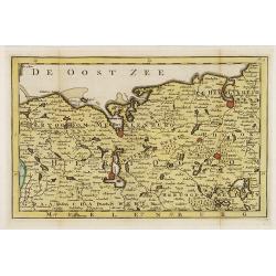
Hertogdom Meklenburg aan de Oostzee.
Uncommon and detailed map of Mecklenburg, including the towns of Rostock, Wismar Swerin and Gustrow. Included in "Zak en reis Atlas van Duitsland". Engraved by ...
Date: Amsterdam, N.T. Gravius, 1750
Selling price: ????
Please login to see price!
Sold in 2017
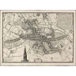
A Plan of the City of Coventry Surveyed in MDCCXLVIII & IX by Samuel Bradford and Engraved by Thos. Jefferys
Rare and important plan of Coventry by T. Jefferys.A large and detailed plan of Coventry, engraved and published by Thomas Jefferys in 1750 after a survey of Samuel Bradf...
Date: London, 1750
Selling price: ????
Please login to see price!
Sold in 2010
A Plan of the City of York Survey'd By Peter Chassereau / Plan de la Ville et foubourgs de York. Capitale de le Comté du meme Nom levé par le Sr. P: Chassereau & Publié par Rocque a Charing Cross 1750
Rare plan of York by J. RocqueA large and detailed copper engraved plan of York, published by John Rocque in 1750 after a survey of Peter Chassereau. Surrounded by 10 ins...
Date: London, 1750
Selling price: ????
Please login to see price!
Sold in 2010
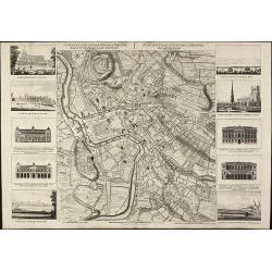
A Survey of the City and Suburbs of Bristol Survey'd by John Rocque Land Surveyor at Charing Cross, 1750 / Plan de la Ville et Faubourgs de Bristol Leve par Jean Rocque a Charing Cross a Londres 1750
Rare map of Bristol by J. RocqueA large and detailed copper engraved map of the city and suburbs of Bristol, draw, serveyed and published by John Rocque in 1750. Surround...
Date: London, 1750
Selling price: ????
Please login to see price!
Sold in 2010
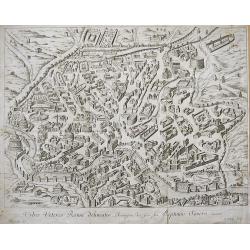
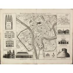
URBIS VETERIS ROMAE DELINEATIO...
Nice engraved bird's-eye plan view of ancient Rome with great detail of the buildings, streets, and monuments... Very decorative engraving by P. Philip. Rare to appear o...
Date: ca. 1750
Selling price: ????
Please login to see price!
Sold in 2010
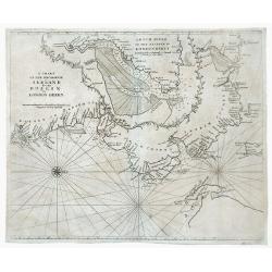
A Chart of the Seacoasts of Ireland from Dublin to London Derry.
Map showing the Irish coast from Dublin heading northeast to the city of Londonderry. The inset, partitioned with a leafy garland, details the passageway leading to Londo...
Date: London, 1750
Selling price: ????
Please login to see price!
Sold in 2010
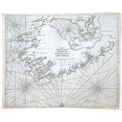
The Southwest Coast of Ireland from Dungarvan to the River Shannon.
Map showing the southwest coast of Ireland and cities within Waterford, Cork and Kerry counties. An inset at the top of the map, divided with a leafy garland, details the...
Date: London, 1750
Selling price: ????
Please login to see price!
Sold in 2010
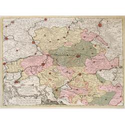
Nova et Accurata Hannonia Comitatus.
Detailed map of Belgium region centered around the city of Bergen Mons (Mons) in the center area of map. Also includes the cities of Douay (Douai), Valencienne and Brusse...
Date: Antwerp, 1720-1750
Selling price: ????
Please login to see price!
Sold in 2010
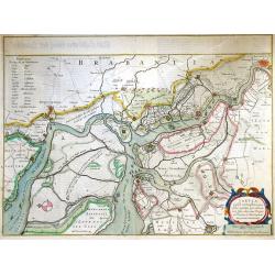
Tabula Castelli ad Sanflitam, qua fimul inundati agri, alluvio nes, fossae, alvei, quae Bergas ad Zomam et Anverpiam interjacent, annotantur. . .
Fine, beautifully colored map of the Antwerp region of Belgium. Fleets of ships are depicted sailing in and out of the city of Antwerp. The city of Bergen op Zoom is also...
Date: Amsterdam, c. 1750
Selling price: ????
Please login to see price!
Sold in 2010
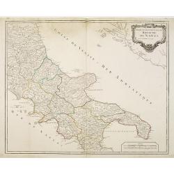
Partie septentrionale du Royaume de Naples.
Map of the southern part of Italy with Naples.
Date: Paris, c.1750
Selling price: ????
Please login to see price!
Sold in 2011
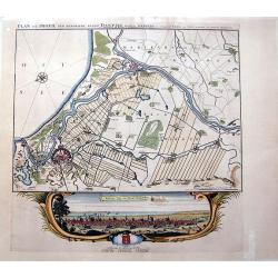
PLAN EN PROFIL DER BEROEMDE STADT DANTZIG derselver WERDERS, en omleggende Landen,...
SCARCE map of Danzig (Gdansk) in Poland. Superbly engraved and very detailed map of the city and its surroundings, showing small towns with single buildings, fields, woo...
Date: Amsterdam, ca. 1750
Selling price: ????
Please login to see price!
Sold in 2010
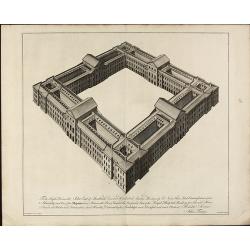
To the Right Honourable John Earl of Sandwich ... View of the Royal Hospital Building for Sick, and Hurt Seamen at Hasler near Portsmouth
A perspective view of the Royal Hospital Building for Sick and Hurt Seamen at Haslar, near Portsmouth. It is inscribed Theodore Jacobsen Esqr. Architect-Fourdrinier Sculp...
Date: London, 1750
Selling price: ????
Please login to see price!
Sold in 2010
Les Environs de l'orient et du Port Louis. Dédiés à Monseigneur le comte d'Argençon Ministre et Secretaire d'Etat de la Guerre
A very large and rare map of Port Louis and Lorient by Le RougeThe copper engraved map published by G. L. le Rouge in 1750 and printed from two plate. It shows the area a...
Date: Paris, 1750
Selling price: ????
Please login to see price!
Sold in 2010
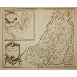
La Judée ou Terre Sainte divisé en ses douze Tribus, ...
A finely engraved and uncommon map depicting the division of the Holy Land into twelve tribes. In upper left hand corner inset map of land of Canaan. Decorative title car...
Date: Paris, 1750
Selling price: ????
Please login to see price!
Sold in 2011
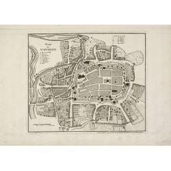
Plan de Schweidniz.
A rare plan of Schweidnitz (today Swidnicaat) in Silesia by Le Rouge. Showing the fortified city. With a key from A to H. We only could locate one copy of this plan in th...
Date: Paris, 1750
Selling price: ????
Please login to see price!
Sold in 2015
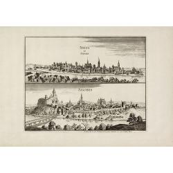
Neiss en Silesia / Teschen.
Very rare city views of Neisse (today Nysa) and Teschen (today Cieszyn) in Silesia after Merian by Le Rouge. Showing the prospects of both cities on one sheet. We only co...
Date: Paris, 1750
Selling price: ????
Please login to see price!
Sold in 2010
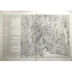
Carte Géometrique de la Ville et des Environs de Gene, ou on voit l'Expedition des Imperiaux et Piemontois contre les Genois et leurs alliez, avec les differents Postes, Retranchements, attaques, déffenses, et Mouvements des deux Parties, le tout desine s
RARE and unidentified map of the area around Genoa (Genova) in Italy. Large map, superbly engraved. With an extensive key to the right, identifying numerous fortification...
Date: ca. 1750
Selling price: ????
Please login to see price!
Sold in 2011
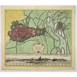
Stadt und Vestung Strasburg samt dem Fort Kehl.
Scarce decorative town-plan of Strasbourg with fine panoramic view of the city.
Date: Nuremberg, 1750
Selling price: ????
Please login to see price!
Sold in 2011
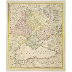
Tabula Geographica qua pars Russiae Magnae. . .
Homann's map is based upon the works of George von Mengden (1628-1702) a Livonian cartographer who worked for Peter the Great and Count Jacob Bruce [Graf Jakov Villimovic...
Date: Nuremberg, after 1750
Selling price: ????
Please login to see price!
Sold in 2010
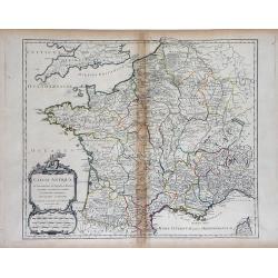
Gallia Antiqua in Provincias et Populos divisa. . .
Large map of Ancient France, divided into provinces, published in de Vaugondy's Atlas Universal. Includes towns, mountains, rivers, lakes and other details. Decorative ti...
Date: Paris, 1750
Selling price: ????
Please login to see price!
Sold in 2010
Carte du Canal des Iles Philippines. . . / Kaart van het kanaal in de Filippynsche eilanden waar door het galjoen van Manilla passeert te gelyk met de naastgelegen eilanden.
Splendid chart of the Philippines illustrating the track of the Manila galleon route. The coasts of the islands are fairly accurately charted but there are no details inl...
Date: Amsterdam, ca. 1750
Selling price: ????
Please login to see price!
Sold in 2015
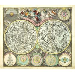
Planisphaerium Coeleste.
A very decorative double hemisphere celestial chart, centered on the North and South Poles, with smaller circular diagrams illustrating the theories of Tycho, Ptolemy, La...
Date: Augsburg, 1750
Selling price: ????
Please login to see price!
Sold in 2010
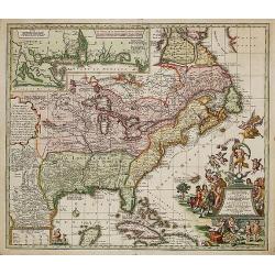
Accurata delineatio Regionis Ludovicianae.
Map of the eastern part of North America focusing on the Mississippi River and the Graet Lakes. Copper engraving with original wash color by M. Rhein, published by Matth�...
Date: Augsburg, c. 1745/1750
Selling price: ????
Please login to see price!
Sold
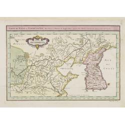
Carte du Katay ou Empire de Kin, Pour servir a l'histoire de Jenghiz Khan. raportée dans l'histoire generale des voyages. Tirée de l'Anglois.
Fine map of Korea and China's Yellow Sea. Complete title in top: Carte du Katay ou Empire de Kin, pour servir de l'Histoire de Jenghiz Khan. Raportée dans histoire Gén�...
Date: Paris, 1750
Selling price: ????
Please login to see price!
Sold in 2011
Carte du Katay ou Empire de Kin. . .
Fine map of Korea and China's Yellow Sea. Complete title in top: Carte du Katay ou Empire de Kin, pour servir de l'Histoire de Jenghiz Khan. Raportée dans histoire Gén�...
Date: Paris, 1750
Selling price: ????
Please login to see price!
Sold
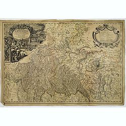
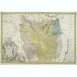
Tabulae principatus Brandenburgico culmbacensis sive baruthini. . .
Decorative map of Upper Franconia. The map was prepared by J. A. Riediger. From Graefental to Lauf, from Eger to Lichtenfels. Very decorative title cartouche with allegor...
Date: Nuremberg, 1750
Selling price: ????
Please login to see price!
Sold in 2023
Principatus silesiae Schwidnicencis. . .
Detailed map centered on Swidnica, south-west of Breslau (Wroclaw). Published in Atlas Silesiae Id Est Ducatus Silesiae Generaliter Quatuor Mappis Nec Non Specialiter XVI...
Date: Nuremberg, 1750
Selling price: ????
Please login to see price!
Sold in 2011
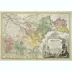
Principatus silesiae Bregensis. . .
Detailed map centered on Brzeg, south east of Breslau (Wroclaw). Published in Atlas Silesiae Id Est Ducatus Silesiae Generaliter Quatuor Mappis Nec Non Specialiter XVI Ma...
Date: Nuremberg, 1750
Selling price: ????
Please login to see price!
Sold in 2011
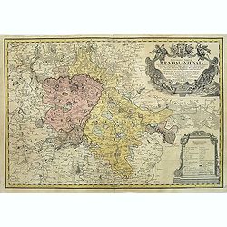
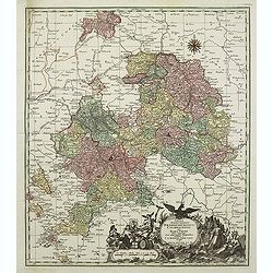
Principatus Silesiae Wratislaviensis exactissima tabula geographica. . .
Beautiful large scale map of Silesia, centered around Breslau (Wroclaw) with the River Oder. Published in Atlas Silesiae Id Est Ducatus Silesiae Generaliter Quatuor Mappi...
Date: Nuremberg, 1750
Selling price: ????
Please login to see price!
Sold in 2011
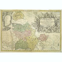
Principatus Silesiae GLOGOVIENSIS novissima Tabula Geographica sistens VI ejusdem Circulos Glogau Freystadt Guhrau Sprottau Grünberg et Schwiebus cum Districtu Polckwitz nee non Liberam Dynastiam Beuthen et Carolath. . .
Detailed map of principality of Grünberg, with an impressive oversized title cartouche depicting the principal coat of arms, gun, spear and game hinting on an area of am...
Date: Nuremberg, 1750
Selling price: ????
Please login to see price!
Sold in 2011
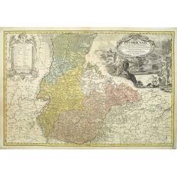
Carte du Diocese de Breslau avec fes IV Arcbidiaco- riats, subdivises en fes cercles archipresbyteriales. . .
Detailed map centered on Breslau (Wroclaw). Beautiful title cartouche in the lower left corner. With a key to the right. Number 4 in left and right lower corners.Publishe...
Date: Nuremberg, 1750
Selling price: ????
Please login to see price!
Sold in 2011
Silesiae Iavoriensis in IV Circulos, Iaver, Hirschberg, Lemberg und Buntzlau divisi ac. . .
Detailed map centered on Jelenia Góra ( Hirschberg), in southwestern Poland. The Sudeten (Sudety) mountains near the Czech border, pictorarily shown.Published in Atlas S...
Date: Nuremberg, 1750
Selling price: ????
Please login to see price!
Sold in 2011
Nieuwe Generale Paskaart van de Bocht van Vrankryk Biscaia en Gallissia tussen I. de Ouessant en C. de Finisterre.
Rare of the Gulf of Biscay including all the south-west coast of France from Brest to the south and continuing along the Spanish coast, including Bilbao, until Ferrol. I...
Date: Amsterdam, ca. 1750
Selling price: ????
Please login to see price!
Sold in 2011
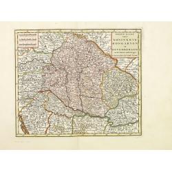
Nieuwe kaart van.. Hongaryen en Sevenbergen. . .
Detailed map of Hungary in attractive full original colors. Isaak Tirion was born in Utrecht ca. 1705. He came to Amsterdam ca. 1725. Tirion published a number of importa...
Date: Amsterdam, 1750
Selling price: ????
Please login to see price!
Sold in 2023
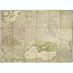
Carte du théatre de la guerre presente entre les Russes, les Polonois et les Turcs. . .
Map of region between the Baltic sea and the Black Sea, published by Jean Lattré and prepared by R. Bonne. The map allowed the French public to follow the Russo-Turkish ...
Date: Bordeaux, c.1750
Selling price: ????
Please login to see price!
Sold in 2011
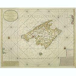
Nieuwe Afteekening van het Eyland Maiorca
So called "Blue-back" sea- of Majorca.Latitude scale, compass rose and system of rhumb lines, soundings, anchorage's, etc. A wealth of cities and information ap...
Date: Amsterdam, 1750
Selling price: ????
Please login to see price!
Sold in 2011

(Title page) Trofées de chasse dessinez par C. Hüet et gravez par Guélard. . .
Decorative title page from the series "Trofées de chasse dessinez" with designs by C. Hüet and engraved by Guélard, published by Jacques Chereau. A very rare...
Date: Paris, c. 1750
Selling price: ????
Please login to see price!
Sold in 2012
Archipel Des Indes Orientales, qui comprend Les Isles De La Sonde.. Philippines..
An attractive and detailed view of the Indonesian islands in large format. Decorative title cartouche.
Date: Paris, 1750
Selling price: ????
Please login to see price!
Sold in 2011
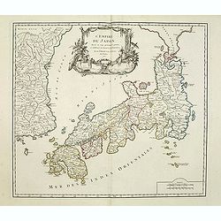
L'Empire du Japon divisé en sept principales parties. . .
Large map of Japan with a distinctively French style title cartouche containing two small landscapes.The map draws heavily on the previous work of Bellin, but includes a ...
Date: Paris, 1750
Selling price: ????
Please login to see price!
Sold in 2011

Per telecopium exhibitio partis inferioris armamentarii.
RARE.
Date: Augsburg, 1750
Selling price: ????
Please login to see price!
Sold in 2011
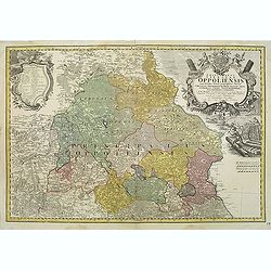
Schlesien Oppeln- 'Principatus Silesiae Oppoliensis exactissima Tabula geographica, sistens Circulos Oppoliensem, Ober-Glogau Gros Strehliz, Cosel, Tost, Rosenberg, Falckenberg & Lubleniz. . .
Detailed map of Southern Poland region of Oppeln. Published in Atlas Silesiae Id Est Ducatus Silesiae Generaliter Quatuor Mappis Nec Non Specialiter XVI Mappis Tot Princi...
Date: Nuremberg 1736 / 1750
Selling price: ????
Please login to see price!
Sold
Principatus Silesiae Teschinensis nova et accurata delineatio distincte insimul exhibens Status minores. . .
Detailed map centered on the Duchy Teschen in Austrian Silesia. Published in Atlas Silesiae Id Est Ducatus Silesiae Generaliter Quatuor Mappis Nec Non Specialiter XVI Map...
Date: Nuremberg, 1736 / 1750
Selling price: ????
Please login to see price!
Sold in 2012
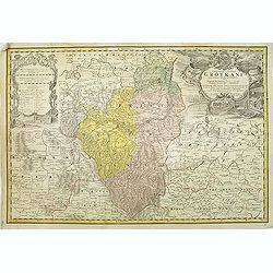
Principatus Silesiae Grotkani exactissima tabula geographica exhibens terram Nissensem simul. . .
Detailed map centered on the region Neisse (Nysa), Grottkau, Ottmachau and Ziegenhals in Poland. Published in Atlas Silesiae Id Est Ducatus Silesiae Generaliter Quatuor M...
Date: Nuremberg, 1736 / 1750
Selling price: ????
Please login to see price!
Sold
![[SET OF 7 MAPS OF CHINA, ca. 1750]](/uploads/cache/91735-250x250.jpg)
[SET OF 7 MAPS OF CHINA, ca. 1750]
Interesting set of seven regional copper-engraved maps and plans of China by or after Bellin, dating to around 1750. List of the maps: 1: Carte des isles qui sont a l'en...
Date: Paris, 1750
Selling price: ????
Please login to see price!
Sold in 2011
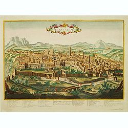
Ierusalem.
A rare, beautifully engraved and richly detailed panoramic view of Jerusalem. Numbered key (1-36) on the lower part with description of most important buildings of Jerusa...
Date: France, c.1750
Selling price: ????
Please login to see price!
Sold in 2011
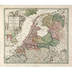
Belgii Pars Septentrionalis Communi Nomine vulgo Hollandia ... / Batavorum Coloniae Occidential Indiis Septentrionalis Americae implantate / India Orientalis Batavorum Commerciis, Potentia & Coloniis celeberrima. / Batavia / Niew Amsterdam.
Original old colored map of the Netherlands by JB Homann. Large inset maps of the Northeastern US from the Chesapeake to Massachusetts and Southeast Asia and additional v...
Date: Nuremberg, c.1750
Selling price: ????
Please login to see price!
Sold in 2011
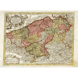
Flandria maximus et pulcherrimus. . .
Flanders: the liberty of Bruges with the island of Cadzand. A decorative map including the towns of Gent, Sluis, Bruges, Ostend, Brussels, Lille, Dunkerque and many other...
Date: Augsburg 1750
Selling price: ????
Please login to see price!
Sold in 2023
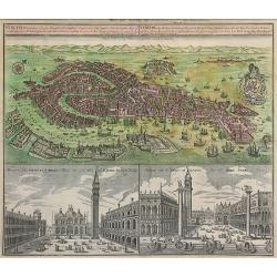
Venetia Potentissima e la più Magnifica...
Striking hand-colored bird's town-plan of Venice with two views of St. Mark's Square (Piazza San Marco), one showing the famous "Gondolas". The detailed plan in...
Date: Augsburg, c.1750
Selling price: ????
Please login to see price!
Sold in 2011
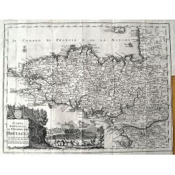
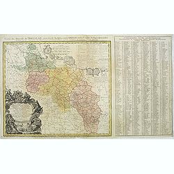
Carta Geografica del Governo della Bretagna.
Attractive and detailed map, showing Brittany divided into its bishoprics and with all towns and cities. Extending to Jersey. With a decorative title cartouche and a view...
Date: Venice, c1750
Selling price: ????
Please login to see price!
Sold in 2011