Browse Listings
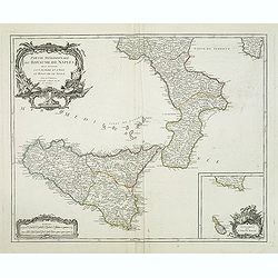
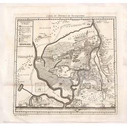
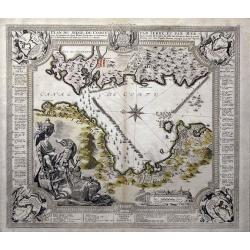
Partie méridionale du royaume de Naples où se trouvent la Calabre et l'isle et royaume de Sicile. . .
Detailed map of Calabria and Sicily, and inset map with Malte Islands. Dated 1750.Ornated with a large title cartouche and a scale cartouche in the left corners. Inset ma...
Date: Paris, 1750
Selling price: ????
Please login to see price!
Sold in 2011
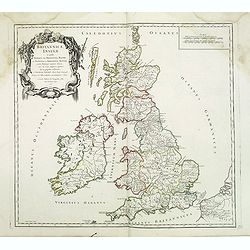
Britannicae, Insulae in quibus Albion sen Britannia Major, . . .
British Isles from his "Atlas Universel".Gilles Robert de Vaugondy (1688–1766), also known as Le Sieur or Monsieur Robert, and his son, Didier Robert de Vaugo...
Date: Paris, 1750
Selling price: ????
Please login to see price!
Sold in 2016
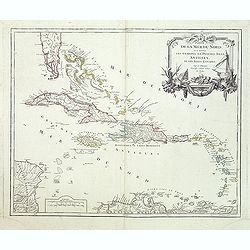
Partie de la Mer du Nord, ou se trouvent les Grandes et Petites Isles Antilles, et les Isles Lucayes.
The coast of Venezuela from Cartagena to Cumana is also included. The tip of Florida and the Bahamas in the upper left corner. In the right upper corner a decorative titl...
Date: Paris, 1750
Selling price: ????
Please login to see price!
Sold in 2011
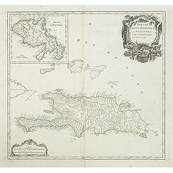
Isles de Saint Domingue ou Hispaniola, et de la Martinique.
A large map of Santo Domingo, with an inset showing the island of Martinique from his "Atlas Universel".Gilles Robert de Vaugondy (1688–1766), also known as L...
Date: Paris, 1750
Selling price: ????
Please login to see price!
Sold in 2011
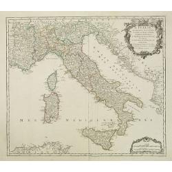
L'Italie qui comprend les états de Piémont. . .
Detailled map of Italy, including the island of Corsica, Sardaigna and Sicily from his "Atlas Universel".Gilles Robert de Vaugondy (1688–1766), also known as ...
Date: Paris, 1750
Selling price: ????
Please login to see price!
Sold in 2018
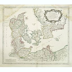
Royaume de Danemark. . .
Detailed map of Denmark, including the Baltic Sea and part of Sweden. Showing towns, rivers, mountains, ports, islands, etc. Large title cartouche, with erased date and p...
Date: Paris, c.1750
Selling price: ????
Please login to see price!
Sold in 2013
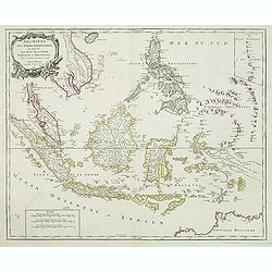
Archipel Des Indes Orientales, qui comprend Les Isles De La Sonde.. Philippines..
An attractive and detailed view of the Indonesian islands in large format and Malacca and Southern China to the Philippines, New Guinea and Northern Australia. Includes a...
Date: Paris, 1750
Selling price: ????
Please login to see price!
Sold in 2013
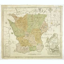
Charta öfwer Skåne. Med Kongl. Maj.ts. nådigste privilegio utgifven af Kongl. Landtmäteri Contoiret.
A scarce map of the district of Skåne in Sweden. A large title cartouche lower right and a key in the lower left corner. The map is a part of a work by Kongl. Landtmäte...
Date: Stockholm, c.1750
Selling price: ????
Please login to see price!
Sold in 2013
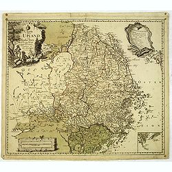
Charta öfwer Upland och Söder Törn. Med Kong. Maj.ts. Nådigste privilegio utgifven af Kongl. Landtmäteri Contoir.
A scarce map of the district of Upland in Sweden. A large title cartouche upper left and a key in the upper right corner. The map is a part of a work by Kongl. Landtmäte...
Date: Stockholm, c.1750
Selling price: ????
Please login to see price!
Sold in 2012
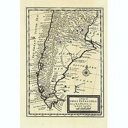
A map of Chili. Patagonia. Part of La Plata & C.
Detailed map showing the southern most part of South America's coastlines, including details of the Falkland Islands.
Date: London, c.1750
Selling price: ????
Please login to see price!
Sold in 2012
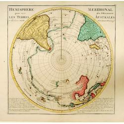
Hemisphere Meridional pour voir plus distinctement..
Uncommon edition of a map of the South Pole prepared De l'Isle and re-issued by De Leth brother's. De l'Isle approach was much more scientific than that of his predecesso...
Date: Amsterdam, 1750
Selling price: ????
Please login to see price!
Sold in 2013
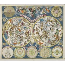
Planisphaerium Coeleste.
A very decorative double hemisphere celestial chart, centered on the North and South Poles, with smaller circular diagrams illustrating the theories of Tycho, Ptolemy, La...
Date: Augsburg, 1750
Selling price: ????
Please login to see price!
Sold in 2013
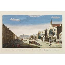
A View of the grand Palace of Westminster. / Vüe du Palais Episcopal de Westminster.
So-called optical print illustrating a perspective view of the old Palace of Westminster where the Lords and Commons met and the square facing it.In the eighteenth and ni...
Date: London, c.1750
Selling price: ????
Please login to see price!
Sold in 2019
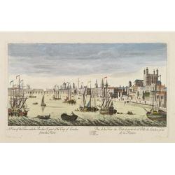
A View of the Tower with the Bridge & part of the City of London from the River. Vue de la Tour du Pont et partie de la Ville de Londres prise de la Riviere.
So-called optical print illustrating part of the city of London, taken from the river Thames. With numbered key list. Engraved by Charpentier.In the eighteenth and ninete...
Date: London, c.1750
Selling price: ????
Please login to see price!
Sold in 2013
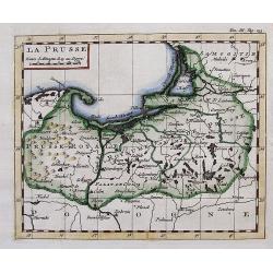
LA PRUSSE.
Interesting small map with parts of today Poland, Kaliningrad Oblast, and Lithuania. Detailed map, includes the cities of Gdansk, Konigsberg (Kaliningrad), Memel (Klaiped...
Date: ca. 1750
Selling price: ????
Please login to see price!
Sold in 2012
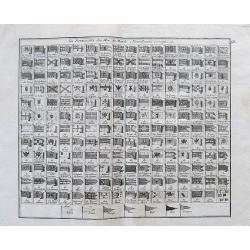
Les Pavillons des Mer du Monde Nouvellement Corriges.
Rare sheet with 192 maritime flags of nations and provinces with French names. With many interesting flags, like the one of Mallorca, Corsaires, Constantinople, Ragusa, W...
Date: Paris, c1750
Selling price: ????
Please login to see price!
Sold in 2012
A Survey of the City and Suburbs of Bristol Survey'd by John Rocque Land Surveyor at Charing Cross, 1750 / Plan de la Ville et Faubourgs de Bristol Leve par Jean Rocque a Charing Cross a Londres 1750
Rare "carte à figures"- map of Bristol by J. Rocque.A large and detailed copper engraved map of the city and suburbs of Bristol, draw, surveyed and published b...
Date: London, 1750
Selling price: ????
Please login to see price!
Sold in 2012
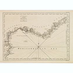
13th Chart including the coast of France, in the mediterranean sea.
Engraved chart of the coast of Provence and Languedoc, France, engraved by Thomas Jeffery's.
Date: London, ca.1750
Selling price: ????
Please login to see price!
Sold
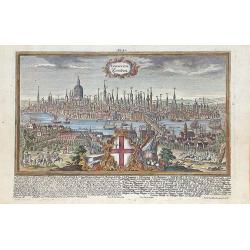
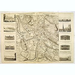
Londinum Londen.
Rare view of London, in nice hand coloring.
Date: Augsburg, 1750
Selling price: ????
Please login to see price!
Sold in 2012
Amplissima Ucraniae Regio, Palatinatus Kioviensem et Braclaviensem...
An uncommon and attractive map of the Ukraine. With excellent detail of the topography, including rivers, hills, etc. Decorated with two attractive cartouches showing...
Date: Augsburg, c1750
Selling price: ????
Please login to see price!
Sold in 2012
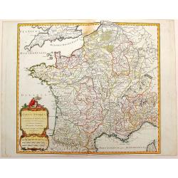
Gallia Antiqua in Provincias et Populos Divisa
This large map of the Roman time Gauls (Gallia) dated 1750, was incorporated in the 1st edition of "Atlas Universel" in 1757. With significant portions of Belgi...
Date: Paris, 1750
Selling price: ????
Please login to see price!
Sold in 2015
![[No tittle] Folding map centered on the Bodensee, Zurichersee](/uploads/cache/30634-250x250.jpg)
[No tittle] Folding map centered on the Bodensee, Zurichersee
Beautiful and detailed map of the area around the Bodensee, including Konstanz, Liechtenstein, Zurich and Fussen in the east, etc More about folding maps. [+]
Date: Germany, ca. 1750
Selling price: ????
Please login to see price!
Sold in 2013
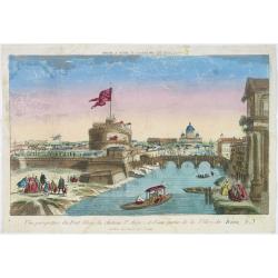
Vue perspective du pont Elian, du château St Ange, et d'une partie de la ville de Rome.
A view of the Castle of St.Angelo and Elian Bridge, with part of the city of Rome. Published by Jacques Chereau, who was a well-known publisher of optical prints, establi...
Date: Paris, ca. 1750
Selling price: ????
Please login to see price!
Sold in 2016
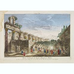
Ruine du Temple de Jupiter Olimpien à Athênes les Turcs en sont aujour d'huy une rue quil leur sert de Marché aux fruits et aux legumes.
Optical print of the ruins of the Temple of Jupiter Olympius in Athenes. This famous temple was build by Antiochus. Published by Jacques Chereau, who was a well-known pub...
Date: Paris, ca. 1750
Selling price: ????
Please login to see price!
Sold in 2016
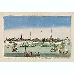
Hambourg, ville d'Allemagne dans le duché de Holstein. . .
Showing the town of Hamburg seen from the river Elbe. Optical print published by Mondhare, who was a well-known publisher of optical prints, established in rue St. Jacque...
Date: Paris, ca. 1750
Selling price: ????
Please login to see price!
Sold in 2015
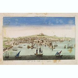
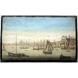
Vue de la ville de Naples. . .
A decorative view of Naples with a busy harbour, published by Basset, who was a well-known publisher of optical prints, established in rue St. Jacques in Paris. In the ei...
Date: Paris, ca. 1750
Selling price: ????
Please login to see price!
Sold in 2014
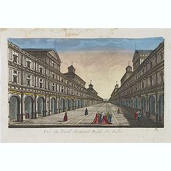
Vue du serail du grand Mogol, des Indes.
Optical print of a Mogul Palace in India. Published by Jacques Chereau, who was a well-known publisher of optical prints, established in rue St. Jacques in Paris. In the ...
Date: Paris, ca. 1750
Selling price: ????
Please login to see price!
Sold in 2019
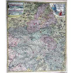
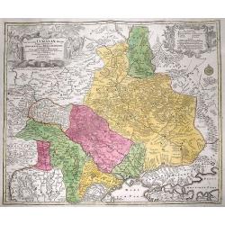
TABULA GEOGRAPHICA CAMPANIAE...
Decorative copper engraved map of Champagne. Very detailed, covering the region Champagne-Ardenne with Reims, Troyes, Châlons, Vitry, and Épernay. With an allegoric tit...
Date: Nuremberg, 1750
Selling price: ????
Please login to see price!
Sold in 2013
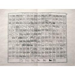
Les Pavillons des Mer du Monde Nouvellement Corriges.
Rare sheet with 192 maritime flags of nations and provinces with French names. With many interesting flags, like the one of Mallorca, Corsaires, Constantinople, Ragusa, W...
Date: Paris, c1750
Selling price: ????
Please login to see price!
Sold in 2013
Accurata delineatio celeberrimae Regionis Ludovicianae ...
Includes the area from the Great Lakes to the Caribbean, and the basin of the river Mississippi in the centre of the map. Part of Louisiana in the top left inset. A very ...
Date: Augsburg, 1750
Selling price: ????
Please login to see price!
Sold in 2013
Nieuwe kaart van Parys en Versailles met de nabygelegen Landstreek en Plaatsen.
Very detailed map covering the vicinity of Paris from Versailles to Vincennes. Nice detail around Boid de Boulogne and St.Cloud
Date: Amsterdam, 1750
Selling price: ????
Please login to see price!
Sold in 2013
![Kaart van den loop der Rivieren de RHYN, de MAAS de MERWE, en de LEK. . . [together with] Kaart van de beneden Rivier de Maas. . . [together with] Nieuwe kaart van 't Kwartier Nijmegen . . .](/uploads/cache/33462-250x250.jpg)
Kaart van den loop der Rivieren de RHYN, de MAAS de MERWE, en de LEK. . . [together with] Kaart van de beneden Rivier de Maas. . . [together with] Nieuwe kaart van 't Kwartier Nijmegen . . .
1./ Kaart van den loop der Rivieren de RHYN, de MAAS de MERWE, en de LEK... (352x450mm.) A detailed map of the center of the Netherlands, with the rivers Rhine, Maas, de ...
Date: Amsterdam, 1750
Selling price: ????
Please login to see price!
Sold in 2013
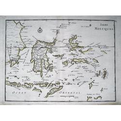
ISLES MOLUQUES.
Highly detailed map of the famous Spice Islands (Maluku Islands or the Moluccas). Includes also Sulawesi, Bali, Timor, part of Borneo, New-Guinea with unfinished coast li...
Date: Paris, c1750
Selling price: ????
Please login to see price!
Sold in 2013
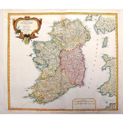
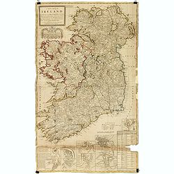
Royaume D'Irelande, Divisee en Ses Quatre Provinces.
A very precise and detailed map of Ireland by "Le Sieur". With large fancy title cartouche and scale table. One of the most beautiful maps of Ireland. Gilles R...
Date: Paris, 1750
Selling price: ????
Please login to see price!
Sold in 2013
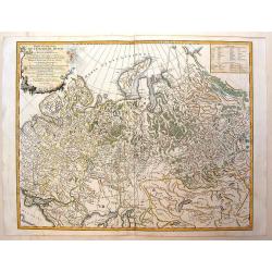
Partie Occidentale de L'Empire de Russie
Detailed map of the western part of the Russian Empire, north of the Black & Caspian Seas, Nova Zembla and including most of Finland. Gilles Robert de Vaugondy (168...
Date: Paris, 1750
Selling price: ????
Please login to see price!
Sold in 2014
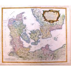
Royaume de Danemarck
Lovely map of Denmark that includes Schleswig-Holstein, the Pomeranian coast and Southern Sweden. Includes a fancy ribboned title cartouche.Gilles Robert de Vaugondy (168...
Date: Paris, 1750
Selling price: ????
Please login to see price!
Sold in 2014
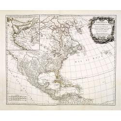
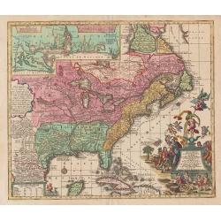
L\'AMERIQUE SEPTENTRIONALE Dressée sur les Relations les plus modernes des Voyageurs. . .
North America with inset of the Northwest including Nouvelle Albion, Strait of Anian, and other various fantastic possibilities of a Northwest Passage (Partie Nord-Ouest ...
Date: Paris, 1750
Selling price: ????
Please login to see price!
Sold in 2013
Vue du petit Voorhout une des promenades de La Haye prise du coté du pont Coucamp.
Showing the Voorhout in The Hague. Likely published by J. Chereau, who was a well-known publisher of optical prints, established in rue St.Jacques in Paris. In the eighte...
Date: Paris, ca. 1750
Selling price: ????
Please login to see price!
Sold in 2013

View of Godston Nunnery Near Oxford.
Pleasant hand-colored print of the famous "Godston Nunnery" close to Oxford in Oxfordshire. The print was by Samuel & Nathaniel Buck who sketched the ruins ...
Date: London, c1750
Selling price: ????
Please login to see price!
Sold in 2013
Carte générale des costes de l'Europe sur l'Ocean comprises depuis Dronthem en Norvege jusques au Detroit de Gibraltar.
General chart of the Atlantic coasts of Europe, from Trondheim in Norway to the Straits of Gibraltar. Prepared by Nicolas Bellin and engraved by H. van Loon.
Date: Paris, 1750
Selling price: ????
Please login to see price!
Sold in 2013
Vue de Deux des Iles des Larrons & Vue de la Cote du N.O. Saypan, une des Iles des Larons.
Views of several of the Mariana Islands in the Philippines Sea in the South Pacific. From George Anson's "Voyage Aurout du Monde". George Anson, 1st Baron Anson...
Date: Paris, 1750
Selling price: ????
Please login to see price!
Sold in 2015
Vue de L'entree de Chequetan ou Seguataneo & Vue de L'Entree du Port d'Acapulco.
Two Mexican coastal views including Zihuatanejo at the top and Acapulco on the bottom vue. From Anson's "Voyage Autour de Monde".George Anson, 1st Baron Anson, ...
Date: Paris, 1750
Selling price: ????
Please login to see price!
Sold in 2015
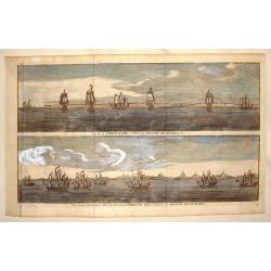
Vue de la Cote du N.E. de L'Isle de Ste. Catherine Sur la Cote du Bresil & Vue de L'Entre Septentionale du Port de Ste. Catherine
Two copper engraved views of the Port of Ste. Catherine off the coast of Bresil. Each shows seven two and three masted ships. George Anson, 1st Baron Anson, PC, FRS, RN ...
Date: Paris, 1750
Selling price: ????
Please login to see price!
Sold in 2015
Cap de la Vierge Marie a L'Entre du Detroit de Magellan & Vue d'Une Partie de la Cote du N.E. de la Terre de Fue a L'Entree du Detroit de la Maire
Hand colored views of two costal areas of Magellan Straight off the coast of Terre del Fuega. Each view has seven two and three masted ship. George Anson, 1st Baron Anso...
Date: Paris, 1750
Selling price: ????
Please login to see price!
Sold in 2013
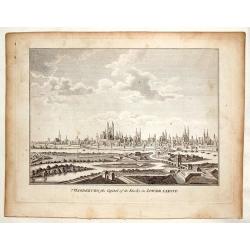
Magdenburg, the Capital of its Duchy in Lower Saxony.
This is a fine copper engraved view of Magdenburg featuring 19 churches with spires, several fortifications and a river system with 10 ships and boats.
Date: Nuremberg, c. 1750
Selling price: ????
Please login to see price!
Sold in 2016
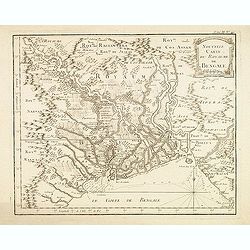
Nouvelle carte du Royaume de Bengale.
Detailed regional map of the Gulf of Bengal and the lower Ganges River.
Date: Paris, c.1750
Selling price: ????
Please login to see price!
Sold in 2015
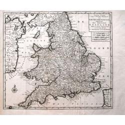
Nieuwe Kaart van 't Zuider Gedeelte van Groot Britannie behelzende Het Koningryk Engeland...
Detailed map of England and Wales, including parts of Ireland. Shows the Picts Wall (Hadrian's Wall)! With a wealth of place names, rivers, roads, areas, etc.
Date: Amsterdam, c1750
Selling price: ????
Please login to see price!
Sold in 2013
Carte du District de Tranquebar.
Decorative, detailed plan of Tharangambadi India, on the Coromandel Coast. It was founded by the Danish East India Company in 1620 and was sold to England in 1845. The ma...
Date: Paris, 1750
Selling price: ????
Please login to see price!
Sold in 2015
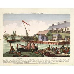
Salem - Eine stadt in Engelländischen America, in der Grafschafft Essex, ... Salem - Une ville de l'Amerique Angloise dans le Comte d'Essex. . .
A so-called optical print. A lively town-view and harbor scene of Salem, Massachusetts, with many people loading a vessel. Engraved by Balthazar Frederic Leizelt.This vie...
Date: Augsburg, 1750
Selling price: ????
Please login to see price!
Sold in 2015

Representation du feu terrible à nouvelle york.
So-called optical print of New York, showing several buildings along street engulfed in flames during fire on September 19, 1776, citizens being beaten by Redcoats, and l...
Date: Augsburg, c. 1750
Selling price: ????
Please login to see price!
Sold in 2013
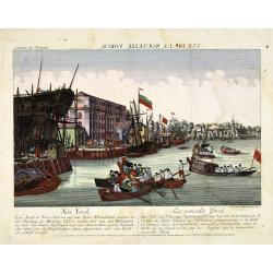
Neu Yorck - Na Nouvelle York.
A so-called optical print engraved by B.F. Leizelt, with underneath captions in German and French. Below the image, Augsburg, "au Negoce commun de l'Academie Imperia...
Date: Augsburg, ca. 1750
Selling price: ????
Please login to see price!
Sold in 2013

Vue Perspective de L'Interieur de L'Eglise des Invalides Prise Dessous les Orgues.
A Vue Optique featuring the interior of the Church of the Invalids in Paris. Jacques Chéreau (1688–1776) was a portrait engraver, printmaker and publisher of optical...
Date: Paris, 1750
Selling price: ????
Please login to see price!
Sold in 2018
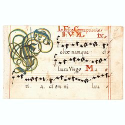
Swiss Gradual Leaf.
A small but attractive music page hand written in Switzerland in the 1700?s with a large opening colored initial.
Date: Switzerland, ca. 1750
Selling price: ????
Please login to see price!
Sold in 2016
![Vue de la Basse Ville a Quebec gegen St. Laurenz Fluss. [together with] Quebeck.](/uploads/cache/34213-250x250.jpg)
Vue de la Basse Ville a Quebec gegen St. Laurenz Fluss. [together with] Quebeck.
Two so-called optical prints showing a decorative imaginary town-view of Québec seen from the harbour, with a large vessel in the foreground. Engraved by François Xavie...
Date: Augsburg, 1750
Selling price: ????
Please login to see price!
Sold
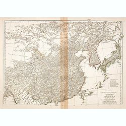
(Map of China, Korea and Japan)
A large detailed map of China, Korea and Japan prepared and published by Jean Baptiste Bourguignon d’Anville. This is the upper part of his two-sheet map of the Far Eas...
Date: Paris, c. 1750
Selling price: ????
Please login to see price!
Sold in 2014

Femmes de Kazegut en differens habits.
The engraving depicts a typical Woman of Kazegut in different costumes, from "Histoire des Voyages.." by Prevost. Below title in Dutch "Vrouwen van Kazegut...
Date: Paris, Didot, ca. 1750
Selling price: ????
Please login to see price!
Sold in 2015
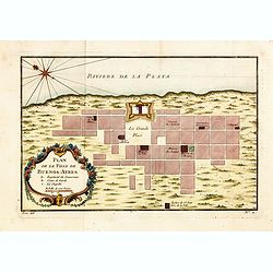
Plan de la Ville de Buenos Ayres.
The early layout of the town of Buenos Aires is shown in blocks, with a few of the important buildings named. Rococo title cartouche at lower left.Jacques Nicolaas Bellin...
Date: Paris, 1750
Selling price: ????
Please login to see price!
Sold in 2014
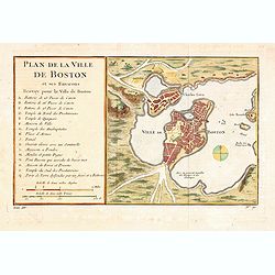
Plan de la Ville de Boston et ses Environs.
One of the earliest obtainable town plans of Boston and Charlestown, with an extensive index of 16 specific sites at left, each located on the map. Shows Boston 13 years ...
Date: Paris, 1750
Selling price: ????
Please login to see price!
Sold in 2014
ACCURATA ET NOVISFIMA REPRAEFENTATIO ICHNOGRAPHIEA HANNOVERAE.
Double-page engraved plan of Hanover by Tobias Conrad Lotter.Showing all the churches and notable places, with an inset decorative shield in the top right with details ab...
Date: Augsburg, 1750
Selling price: ????
Please login to see price!
Sold in 2014

Carte des Isles Voisines des Moluques.
Map of the province of Moluccas, Indonesia including Ceram, Bouro, Amboine and Neyra. Published by Pierre de Hondt for Prevost's "L'HISTOIRE GENERALE DES VOYAGES&quo...
Date: Paris, ca.1750
Selling price: ????
Please login to see price!
Sold in 2016
Plan du siege de Corfu par Terre et par Mer...
This uncommon map depicts the western coast of Corfu, including Kérkira at the time of the siege on July 5th, 1716 against the Turkish marine. Part the Greek coast (prov...
Date: Nuremberg, 1750
Selling price: ????
Please login to see price!
Sold in 2015
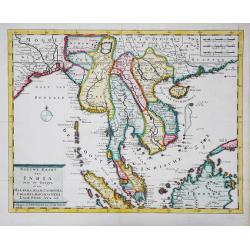
Nieuwe kaart van India over de Ganges, of van Malakka, Siam, Cambodia, Chiampa, Kochinchina, Laos, Pegu, Ava, enz.
Isaac Tirion's attractive map of Indochina, the Malaysian Peninsula and the northern parts of Sumatra and Borneo. The mythical Lac Chaamay is still shown in Acham. Isaak ...
Date: Amsterdam, c. 1750
Selling price: ????
Please login to see price!
Sold in 2016
Isles de Banda.
Striking map of the Indonesian Islands of Banda including Pulorin, Puloway, Gunnanapi, Labetak, Nera etc. It was engraved by Didot in Paris in 1750.
Date: Paris, 1750
Selling price: ????
Please login to see price!
Sold in 2014
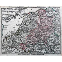
Vereinigte Niederlande, Spanische Niederlande, Herzogt. Brabant, Herzogt. Luxemburg, Graefsch. Flandern.
Detailed miniature map published by Tobias Conrad Lotter and Tobias Lobeck in their "Atlas Geographicus portatilis...".
Date: Augsburg, ca. 1750
Selling price: ????
Please login to see price!
Sold in 2014
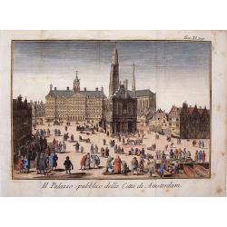
Il Palazzo Publico Della Citta di Amsterdam.
Very pleasing hand colored copper engraving of Amsterdam featuring the Palace.
Date: Venice, 1750
Selling price: ????
Please login to see price!
Sold in 2019
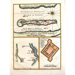
Riviere du Senegal / Isle saint Louis / Petit du Fort St. Joseph.
This 1747 nautical three charts on one page by J.C.Bellin, depicts the Senegal River and the area surrounding Fort St. Joseph & Fort St. Louis. This region was part o...
Date: Paris, 1750
Selling price: ????
Please login to see price!
Sold in 2017
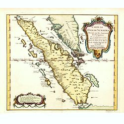
Carte de L'Isle de Sumatra Dressee sur les Journaux des Navigateurs . . .
Detailed map of Sumatra and Malacca, centered on Singapore and including the southern portion of the Malaysian peninsula. With "Detroit de Sincapour" and severa...
Date: Paris, ca. 1750
Selling price: ????
Please login to see price!
Sold in 2014
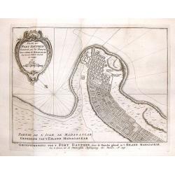
Plan de Fort Dauphin.
A striking plan of the Fort of Dauphin on the southeastern point of Madagascar. It was engraved by J. van Schley and has a fancy decorative title cartouche.
Date: Paris, 1750
Selling price: ????
Please login to see price!
Sold in 2016
A new map of Ireland divided into its provinces, counties and baronies, wherein are distinguished the bishopricks, borroughs, barracks, bogs, passes, bridges &c. with the principal roads, and the common reputed miles
A magnificent and highly detailed late 18th century map of Ireland, with in lower right corner inset town plans of Dublin, Cork, Limerick, Waterford and Gallway, with pla...
Date: London, 1726-1750
Selling price: ????
Please login to see price!
Sold in 2015
The South East prospect of London, from the Tower to London Bridge.
Optical vue of the River Thames, looking to the west from the Tower of London to London Bridge and St Paul's; animated with a number of boats on the water.
Date: Londo, circa 1750
Selling price: ????
Please login to see price!
Sold in 2022
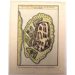
Plan de L'Isle et Ville de Quiloa.
Copper engraved plan of the fortified town of Quiloa on the east coast of Africa. This town was the center of the Portuguese slave trade.
Date: Paris, c. 1750
Selling price: ????
Please login to see price!
Sold in 2016
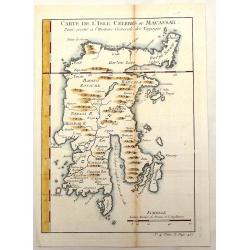
Carte de L'Isle Celebes ou Macassar.
Fine little copper engraved map of Celebes Island, Makassar (Buginese-Makassar language:– sometimes spelled Macassar, Mangkasara) – It is the provincial capital of So...
Date: Paris, 1750
Selling price: ????
Please login to see price!
Sold in 2015
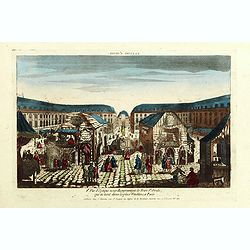
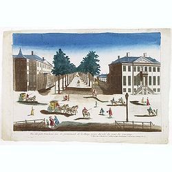
8e Vue d'optique nouvelle représentant la Foire St Ovide qui se tient dans la place Vendôme, à Paris.
Showing the St Ovide fair at the Vendôme Place in Paris. Likely published by J. Chereau, who was a well-known publisher of optical prints, established in rue St.Jacques ...
Date: Paris, ca. 1750
Selling price: ????
Please login to see price!
Sold in 2015
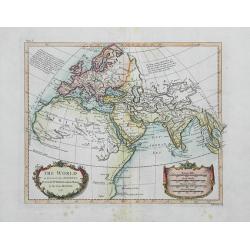
The World as known to the Antients...
Interesting map of the ancient world with notes of Ptolemy. Shows place names, rivers, islands, and mountains. Drawn for Rollin by D'Anville. Decorated with nice colorin...
Date: London, c1750
Selling price: ????
Please login to see price!
Sold in 2016
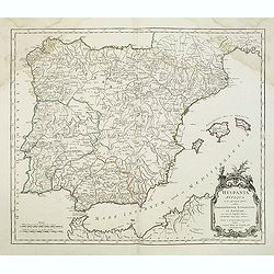
Hispania Antiqua.
Map of ancient Spain and Portugal. Engraved by G. Delahaye. From his "Atlas Universel".Gilles Robert de Vaugondy (1688–1766), also known as Le Sieur or Monsie...
Date: Paris, 1750
Selling price: ????
Please login to see price!
Sold in 2015
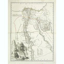
Carte d' l'Egypte ancienne et moderne. . .
Detailed map of the entire Nile Valley from Assouan (Syene) to Damiette from his "Atlas Universel".Gilles Robert de Vaugondy (1688–1766), also known as Le Sie...
Date: Paris, 1750
Selling price: ????
Please login to see price!
Sold in 2015
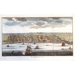
Samboupo.
Detailed view of Samboupo on the island of Celebes (Sulawesi) Indonesia. Over one dozen ships are sailing in the harbour and river. By Jacob van der Schley in 1750.
Date: Paris, 1750
Selling price: ????
Please login to see price!
Sold in 2019

Vue Perspective de L'Universite d'Augsbourg Fonde par L'Eveque Julien.
Original antique print published by Chereau in Paris in c1750. This is an optical print, also called “Vue Optique” or “Vue d'Optique”, which were made to be viewe...
Date: Paris, c1750
Selling price: ????
Please login to see price!
Sold in 2019
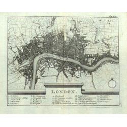
London.
Small French map of London with a key below naming 24 important places within the city. Numerous streets are indicated. Uncommon map, probably dating to around 1700-1750.
Date: Paris, ca. 1700-1750
Selling price: ????
Please login to see price!
Sold in 2016
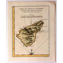
Carte de l'Isle de Teneriffe, Suivant les Observations Astronomiques
A attractive map of the island of Tenerife (Canary Isles) which was produced by Jacques Nicolas Bellin (1703-1772) and published in Prevost's “L'Histoire Générale d...
Date: Paris, 1750
Selling price: ????
Please login to see price!
Sold in 2015