Browse Listings
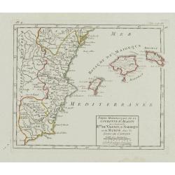
Partie Méridionale de la Couronne d'Aragon.. R.mes de Valence, de Maiorque et de Murcie..
RARE. Small detailed map encompassing the Valencian Community, the region of Murcia and the Balearic Islands.From Atlas Portatif Universel, by Robert de Vaugondy. Page 4 ...
Date: Paris, later than 1749
Selling price: ????
Please login to see price!
Sold in 2010
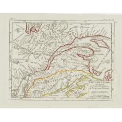
Partie du Canada où se trouvent le Fleuve St. Laurent et la Nouvelle Ecosse.
Nice small map of Canada which shows the last stretch of the Saint Lawrence River, passing Quebec City before draining into the Gulf of Saint Lawrence.Tom 2. Page 184 out...
Date: Paris, later than 1749
Selling price: ????
Please login to see price!
Sold
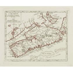
L'Acadie.
Nice small map of Nova Scotia. From Atlas Portatif Universel, by Robert de Vaugondy.Number 100 outside border top right. Mary Sponberg Pedley does not mention a state wit...
Date: Paris, later than 1749
Selling price: ????
Please login to see price!
Sold
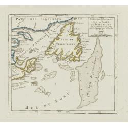
Golfe de St. Laurent, Isle et Bancs de Terre Neuve.
Nice small map showing the Gulf of Saint Lawrence as well as the islands of Newfoundland, Cape Breton and Prince Edward.Number 101 outside border top right. Mary Sponberg...
Date: Paris, later than 1749
Selling price: ????
Please login to see price!
Sold in 2010
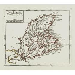
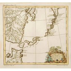
Isle Royale.
Nice small map of Cape Breton Island. From Atlas Portatif Universel, by Robert de Vaugondy.Number 102 outside border top right. Mary Sponberg Pedley does not mention a st...
Date: Paris, later than 1749
Selling price: ????
Please login to see price!
Sold in 2010
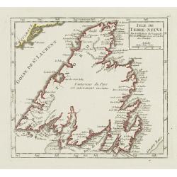
Isle de Terre-Neuve.
Nice small map of Newfoundland. Showing good detail along the coasts. The inland is left blank except for a writing which says that the interior of the Island is complete...
Date: Paris, later than 1749
Selling price: ????
Please login to see price!
Sold in 2015
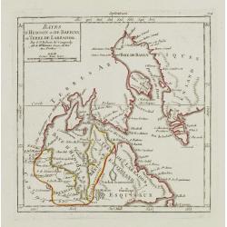
Bayes d'Hudson et de Baffins, et Terre de Labrador.
Very attractive, small map focusing on Labrador, Baffin Bay, Hudson Bay and Greenland.The latter is represented with the three island configuration that began with Sanson...
Date: Paris, later than 1749
Selling price: ????
Please login to see price!
Sold in 2018
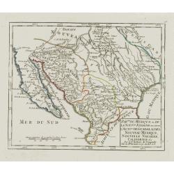
Partie du Mexique où de la Nouv.le Espagne.. Californie &c.
Nice small map showing the northern part of Mexico, from Lower California to Guadalajara.Pedley, Bel et utile, map 461, not mentioning this state.Number 91 outside border...
Date: Paris, later than 1749
Selling price: ????
Please login to see price!
Sold
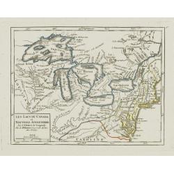
Les Lacs du Canada et Nouvelle Angleterre.
Charming small map showing the Great Lakes region from Superior to Ontario and including the northern part of Pennsylvania below Lake Erie, although the state is not name...
Date: Paris, later than 1749
Selling price: ????
Please login to see price!
Sold
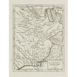
Cours du Mississipi et la Louisiane.
Nice small map showing the course of the Mississippi River, from Minnesota to the Gulf of Mexico.Number 92 outside border top right. Mary Sponberg Pedley does not mention...
Date: Paris, later than 1749
Selling price: ????
Please login to see price!
Sold in 2022
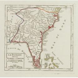
La Floride divisee en Floride et Caroline.
Nice small map representing the southeastern part of the United States, centred on Florida. It shows the Bahamas at the bottom.Number 93 outside border top right. Mary Sp...
Date: Paris, later than 1749
Selling price: ????
Please login to see price!
Sold
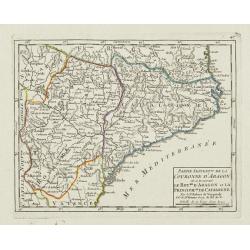
Partie Septent.le de la Couronne d'Aragon où se trouvent le Roy.me d'Aragon.. Catalogne.
Small detailed map of Aragon and Catalonia. From Atlas Portatif Universel, by Robert de Vaugondy.Page 47 outside border top left. Mary Sponberg Pedley does not mention a ...
Date: Paris, later than 1749
Selling price: ????
Please login to see price!
Sold
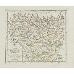
Royaume de Pologne divisé en Haute et Basse Pologne..
Small detailed map showing the southern part of Poland. From Atlas Portatif Universel, by Robert de Vaugondy.Unrecorded state with erased date. Page 37 outside border top...
Date: Paris, later than 1749
Selling price: ????
Please login to see price!
Sold in 2017
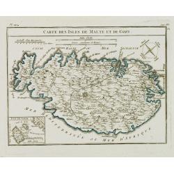
Carte des Isles de Malte et de Goze.
Detailed small map of Malta, with a compass rose in the upper right corner and an inset map of Gozo in the lower left. From Atlas Portatif Universel, by Robert de Vaugond...
Date: Paris, later than 1749
Selling price: ????
Please login to see price!
Sold in 2008
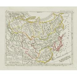
Carte Générale de l'Empire des Russes Contenant la Siberie.. le Kamtchatka.
Small detailed map of Russia. Extending southwards and eastwards to show Korea, Japan, Mongolia and part of China. The title has been reworked from the plate described by...
Date: Paris, later than 1749
Selling price: ????
Please login to see price!
Sold
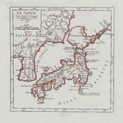
Le Japon.
Small detailed map of Japan and Korea. Dated 1749. A note next to island "Fatsisio ou l'Empereur envoye en exil les Grands".From Atlas Portatif Universel, by Ro...
Date: Paris, later than 1749
Selling price: ????
Please login to see price!
Sold in 2008
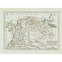
Partie Occidentale de la Terre Ferme.
Small detailed map showing the nor westernmost tip South America. Centered on Venezuela. From Atlas Portatif Universel, by Robert de Vaugondy.Page 106 outside border top ...
Date: Paris, later than 1749
Selling price: ????
Please login to see price!
Sold in 2011
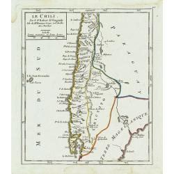
Le Chili.
Deatailed small map showing most part of Chile. Centered on Santiago. From Atlas Portatif Universel, by Robert de Vaugondy. 110 outside border top right. Mary Sponberg Pe...
Date: Paris, later than 1749
Selling price: ????
Please login to see price!
Sold in 2014
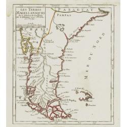
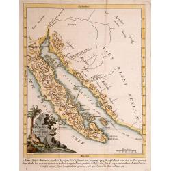
Les Terres Magéllaniques.
Nice small map of the southernmost tip of South America. The Falkland Islands have only partial coastlines.From Atlas Portatif Universel, by Robert de Vaugondy. 111 outsi...
Date: Paris, later than 1749
Selling price: ????
Please login to see price!
Sold in 2009
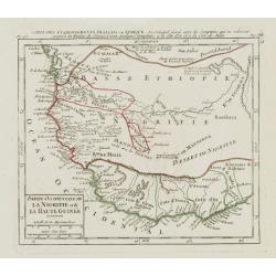
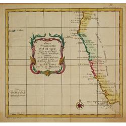
Partie Occidentale de la Nigritie et de la Haute Guinée.
Nice small map illustrating the West African shores between Mauritania and Benin. From Atlas Portatif Universel, by Robert de Vaugondy. 78, Pag.566 outside border top rig...
Date: Paris, later than 1749
Selling price: ????
Please login to see price!
Sold in 2013
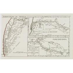
Cours de la Riviere de Sénégal. Depuis le Rocher Gouinea jusqu'à la Mer.
3 small maps in one plate. Illustrating the stretch of the Senegal River constituting the natural border between Senegal and Mauritania. Dated 1749.From Atlas Portatif Un...
Date: Paris, later than 1749
Selling price: ????
Please login to see price!
Sold in 2013
Théatre historique géographique et chronologique du règne de Louis XV Dit le Bien-Aimé. Dedié et présenté au Roy. . .
Uncommon issue of this decorative map showing the Empire of Louis XV (1715-1774). In upper right corner an inset map of the east coast of America, indicating the French p...
Date: Paris, 1749
Selling price: ????
Please login to see price!
Sold in 2008
Regnorum Magnae Britanniae et Hiberniae ...
A General Map of Great Britain and Ireland with Part of Holland, Flanders and France.
Date: Nuremberg, 1749
Selling price: ????
Please login to see price!
Sold in 2011
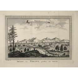
Gezigt van Peking, getrokken uit Nieuhof
This view of Peking is based on an engraging from the publication ''''Het Gezantschap der Neêrlandtsche Oost-Indische Compagnie, aan den grooten Tartarischen Cham, den t...
Date: 1749
Selling price: ????
Please login to see price!
Sold in 2008
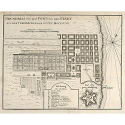
Grundriss von dem Fort und der Stadt auf dem Vorgebirge der Guten Hoffnung
Engraved map of Cape Town in South Africa by Nicolas Bellin. From the German edition of Prévost's "L'Histoire Générale des Voyages" by J. J. Schwabe in Leipz...
Date: Leipzig, 1749
Selling price: ????
Please login to see price!
Sold in 2008
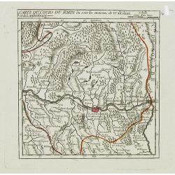
II. Cours du Rhin ou sont les environs de Basle, et de Rhinfelden.
Small detailed map illustrating the stretch of the Rhine which flows between Basel and Rheinfelden.From Atlas Portatif Universel, by Robert de Vaugondy.Unrecorded state w...
Date: Paris, later than 1749
Selling price: ????
Please login to see price!
Sold in 2021
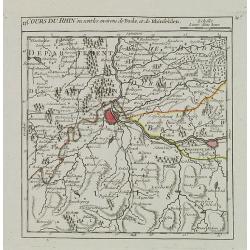
I. Carte du Cours du Rhin où sont les environs de Waltshut, et de Laufenburg.
Small detailed map centered on Laufenburg, illustrating the first stretch of the Rhine which flows between Germany and Switzerland.From Atlas Portatif Universel, by Rober...
Date: Paris, later than 1749
Selling price: ????
Please login to see price!
Sold in 2013
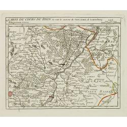
VI. Carte du Cours du Rhin où sont les environs du Fort, Louis, de Lauterburg d'Haguenau.
Small detailed map illustrating the stretch of the Rhine which flows between Fort-Louis and Hochstetten.From Atlas Portatif Universel, by Robert de Vaugondy.Unrecorded st...
Date: Paris, later than 1749
Selling price: ????
Please login to see price!
Sold in 2019
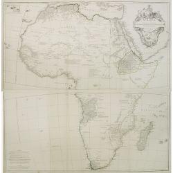
Afrique publiée sous les auspices de Monseigneur le Duc d'Orléans. . .
Very fine engraved wall map of Africa with a very decorative title cartouche. Giving good detail along the coast. Uncommon.
Date: Paris, 1749
Selling price: ????
Please login to see price!
Sold in 2008
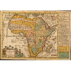
Africa verfertiget von J. G. Schreibern in Leipzig
Small scale map of Africa by J. G. Schreiber, from his Atlas Selectus in 1749, first published in 1740. Nice cartouche with elephant, lion and palm trees.
Date: Leipzig, 1749
Selling price: ????
Please login to see price!
Sold in 2009
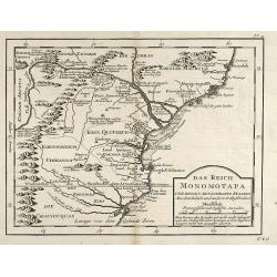
Das Reich der Monomotapa und dessen benachbarte Staaten.
Engraved map of Mozambique in Southeast Africa by Nicolas Bellin. From the German edition of Prévost's "L'Histoire Générale des Voyages" by J. J. Schwabe in ...
Date: Leipzig, 1749
Selling price: ????
Please login to see price!
Sold in 2009
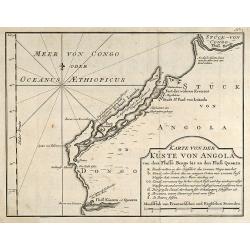
Karte von der Küste von Angola von dem Flusse Bengo bis an den Fluß Quanza.
Engraved map of the coastal line of Angola in Southwest Africa by Nicolas Bellin. From the German edition of Prévost's "L'Histoire Générale des Voyages" by J...
Date: Leipzig, 1749
Selling price: ????
Please login to see price!
Sold in 2010
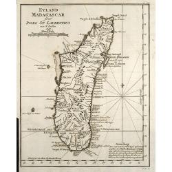
Eyland Madagascar sonst Insel St Laurentius
Engraved map of the Island of Madagascar in the Indian Ocean by Nicolas Bellin. From the German edition of Prévost's L'Histoire Générale des Voyages by J. J. Schwabe i...
Date: Leipzig, 1749
Selling price: ????
Please login to see price!
Sold in 2009
Das gantze Russische Kaeyserthum mit allen seinen Laendern verfertiget von J. G. Schreibern in Leipzig.
Small scale map of Russia by J. G. Schreiber, from his "Atlas Selectus" from 1749, first published in 1740. Showing the area between Reval; Novaja Semlja; Japan...
Date: Leipzig, 1749
Selling price: ????
Please login to see price!
Sold in 2014

Carte du Katay, ou Empire de Kin : pour servir a l'Histoire de Jenghiz Khan, raportée dans l'Histoire generale des voyages, tirée de l'Angloise.
The map is of interest for the use of East Sea, the sea between Korea and Japan, here called "Mer de Corée".Fine map of Korea and China's Yellow Sea. Complete ...
Date: Paris, 1750
Selling price: ????
Please login to see price!
Sold in 2023

L'Empire de la Chine. . .
Detailed map of China, Korea and Taiwan. The large title cartouche is resplendent in the French style with musicians, a dancer, and various accouterments representative o...
Date: Paris, dated 1750
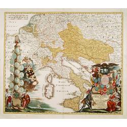
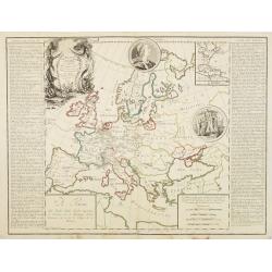
Tabula Geographica Europae Austriacae generalis..
Johann Baptist Homann's well-engraved map has a large decorative cartouche at bottom right and left showing a throned ruler, showing the Austrian possessions in Europe.
Date: Nuremberg 1750
Selling price: ????
Please login to see price!
Sold
Royaume d'Irlande divisé en ses quatre Provinces
Fine map of Ireland, engraved by the master Delahaye. Fine title cartouche.
Date: Paris 1750
Selling price: ????
Please login to see price!
Sold
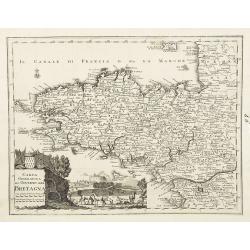
Carta geografica del governo della Bretagna. . .
From Volume II of Albrizzi's "Atlante Novissimo" after Guillaume de L'Isle. Showing Brittany divided into its Bishoprics and with all towns and cities marked, w...
Date: Venise, 1750
Selling price: ????
Please login to see price!
Sold
't Land Kanaan..
This map depicts Palestine divided into the twelve tribes. It is finely engraved and shows towns, villages and rivers. Decorated with a title cartouche, a bible scene and...
Date: Amsterdam 1750
Selling price: ????
Please login to see price!
Sold

Het West Indisch Huys.
"A decorative print of the ""West Indian House"", the headquarters of the WIC (West Indian Company), a place for meeting, trading and storage of ...
Date: Amsterdam 1750
Selling price: ????
Please login to see price!
Sold
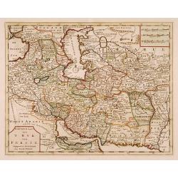
Nieuwe kaart van 't Ryk van Persie.
A detailed map of Persia and its adjoining countries.
Date: Amsterdam 1750
Selling price: ????
Please login to see price!
Sold
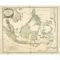
Archipel Des Indes Orientales, qui comprend Les Isles De La Sonde.. Philippines..
Good condition. Some marginal water stains. Paper very slightly age toned. Very good.
Date: Paris, 1750
Selling price: ????
Please login to see price!
Sold in 2015
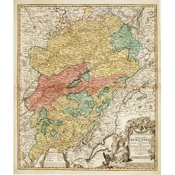
Comitatus Burgundiae tam in primarias ejus ..
A good map of Burgundy orientated with north at the top. Decorative title cartouche with three figures, scale cartouche, coat of arms and putti holding grapes.Lower part ...
Date: Augsburg 1750
Selling price: ????
Please login to see price!
Sold
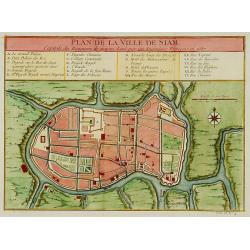
Plan de la ville de Siam.
Early plan of Siam, Thailand. Across the top is an extensive list of 22 important sites and locations keyed to the plan with tiny letters and numbers.Jacques Nicolaas Bel...
Date: Paris 1750
Selling price: ????
Please login to see price!
Sold
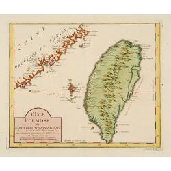
L'Isle Formose et Partie des Costes de la Chine.
This well-known map of Taiwan is based on Jesuit information. The text along the island's east-coast claims: Of this coast little is known .Jacques Nicolaas Bellin (1703-...
Date: Paris 1750
Selling price: ????
Please login to see price!
Sold
Tierra del Fuogo.
An attractive map centred on the extreme part of South America, including the Horn Cape.
Date: Venice 1750
Selling price: ????
Please login to see price!
Sold
TERRE de CANAAN à présent la PALESTINE.
Uncommon map of the Holy Land oriented to the west.
Date: France, c.1750
Selling price: ????
Please login to see price!
Sold
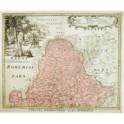
Circuli Olomucensis pars Borealis.
Beautiful decorative cartouche upper right with the legend and very beautiful figurative scene upper left corner.
Date: Nurimberg, c.1750
Selling price: ????
Please login to see price!
Sold
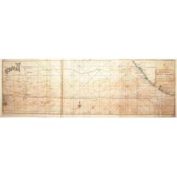
A chart of the Pacific Ocean from the Equinoctial to the ..
Chart detailing the route of Spanish galleons between the Philippines and Acapulco. The tracks of British Navy Commodore George Anson and Spanish Nostra Seigniora de Caba...
Date: London 1750
Selling price: ????
Please login to see price!
Sold
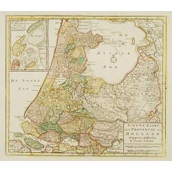
Nieuwe kaart der Provincie van Holland.
In upper left hand corner inset map of Kaartje van de Helder Texel Vlieland en Wieringen . Including the province of Utrecht and the Veluwe.
Date: Amsterdam 1750
Selling price: ????
Please login to see price!
Sold
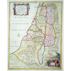
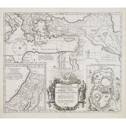
La Judée ou Terre Sainte divisé en sous..
A finely engraved and uncommon map depicting the division of the Holy Land into twelve tribes. In upper left hand corner inset map of land of Canaan. Decorative title car...
Date: Paris 1750
Selling price: ????
Please login to see price!
Sold in 2008
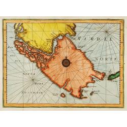
CALIFORNIA per P.Ferdinandum Con sak S.I. et alias.
Map of Mexico and the peninsular of California. Underneath the print a note about the region. Lower left a monogram E.V. of the engraver.
Date: c. 1750
Selling price: ????
Please login to see price!
Sold
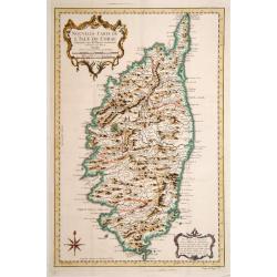
Nouvelle Carte de L'Isle de Corse..
Fine map of Corsica.
Date: Paris 1750
Selling price: ????
Please login to see price!
Sold
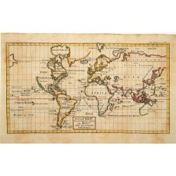
Richtige Charte von allen bekannten theilen der Welt ..
Uncommon map of the world in Mercator projection. Title cartouche centered on the lower part of the document. Showing the track of Anson. With an incomplete coastline of ...
Date: Germany 1750
Selling price: ????
Please login to see price!
Sold
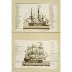
A first rate ship hoisting the Vice Admirals flag./ A first rate ship carrying a flag at the main top mast head.
Two decorative prints of a first rate ship, with title and on each side a numbered keys (A-UUU, 1-51) in English and French.Engraved by G.Scotin. Very decorative.
Date: London 1750
Selling price: ????
Please login to see price!
Sold
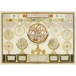
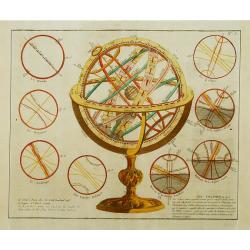
Introduction a la géographie carte des diverses positions de la sphere. . .
A charming and large print showing a terrestrial, celestial and an armillary globe with smaller circular diagrams illustrating the theories of Ptolemy, Copernicus, Brahe ...
Date: Paris, 1750
Selling price: ????
Please login to see price!
Sold in 2019
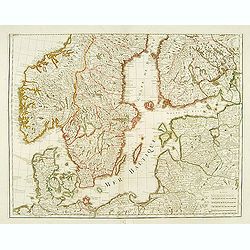
(Map of Scandinavia).
Engraved by "Liébaux, le fils".
Date: Paris, 1750
Selling price: ????
Please login to see price!
Sold in 2008
Carte du Katay ou Empire de Kin..
Fine map of Korea and China's Yellow Sea. Complete title in top: Carte du Katay ou Empitre de Kin, pour servir de l'Histoire de Jenghiz Khan. Raportée dans histoire Gene...
Date: Paris 1750
Selling price: ????
Please login to see price!
Sold
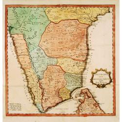
..Karte von der halb=Insil Indiens diesseits dem Ganges.
Fine map of India and northern part of Sri-Lanka. Text is in German. The map is decorated with small elephants, Lions, trees, etc.RARE. Engraved by Christian Liebe, engra...
Date: Halle c. 1750
Selling price: ????
Please login to see price!
Sold
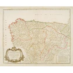
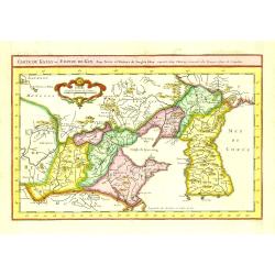
Partie septentrionale de la Couronne de Castille
Detailed map of the north-western part of Spain. Also depicting a small part of southern France.
Date: Paris 1750
Selling price: ????
Please login to see price!
Sold
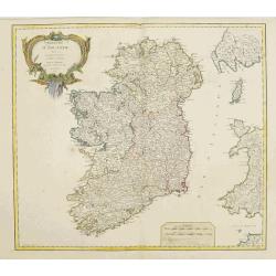
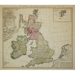
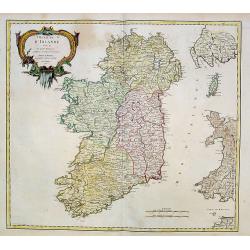
Royaume d'Irlande.
Nice large map of the kingdom of Ireland,divided in the 4 provinces and subdivided in counties,also showing a part of England and of Scotland, fully colored by hand. From...
Date: Paris, 1750
Selling price: ????
Please login to see price!
Sold
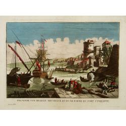
Première vue de l'Isle minorque et d'une partie du Fort St Philippe.
A so-called optical print of the harbour of Majorcal.In the eighteenth and nineteenth centuries there were many popular speciality establishments in Paris, Augsburg and L...
Date: Paris 1750
Selling price: ????
Please login to see price!
Sold
Sphères..
Rare print of an armillary sphere, which is basically a skeletal celestial sphere with a model of the Earth or, later, of the Sun placed in the center. It is useful as a ...
Date: Paris 1750
Selling price: ????
Please login to see price!
Sold
Carte des Isles Kouriles.
A good impression of a detailed, finely engraved map of the north of Honshu. Derived from Russian maps resulting from the expeditions of Bering, Cherikov and others, one ...
Date: Paris 1750
Selling price: ????
Please login to see price!
Sold
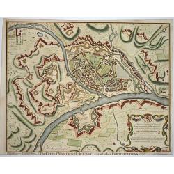
The city of Namur..
Nice fortification plan of the city Namur, with houses churches and even the gardens are visible. A decorative cartouche in the corner. Engraved by J. Basire.
Date: London ca. 1750
Selling price: ????
Please login to see price!
Sold
Coste Occidentale d' Afrique depuis le XIe. Degré jusqu'au Cap de Bonne Esperance.
Jaques Nicolas Bellin (1702-720) was the most important French hydrographer of the 18th century. Sea-atlas 'Hydrographique Français' , 1756-65, atlas to accompany Prévo...
Date: Paris, c. 1750
Selling price: ????
Please login to see price!
Sold
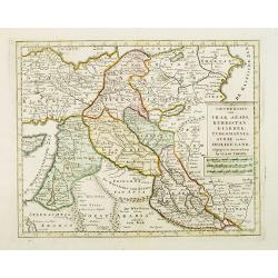
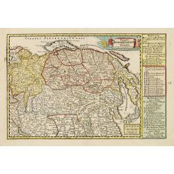
Nieuwe kaart van Irak Arabi, Kurdistan, Diarbek. . .
Detailed map including the northern part of the Arabian peninsular, Palestine, Iraq, Iran and the eastern part of Cyprus.
Date: Amsterdam, 1750
Selling price: ????
Please login to see price!
Sold in 2017
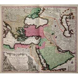
Magni Turcarum dominatoris Imperium
A fine decorative map of the Turkish Empire by Seutter.
Date: Germany, c. 1750
Selling price: ????
Please login to see price!
Sold
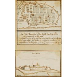
Die Stadt Frankenbar and fort Dansburg.
Charming 18th water color on paper depicting the fortification and town plan of the Danish East India Company Trading post Dansburg on the Indian west coast.In top the ci...
Date: c.1750
Selling price: ????
Please login to see price!
Sold
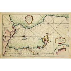
Nouvelle Carte de la Mer Pacifique.
A map in two parts depicting the west coast of South America. Curious is a second coast line of the Chilian coast delineated between 45o S and 50o S in a southwestern dir...
Date: Paris, c. 1750
Selling price: ????
Please login to see price!
Sold
An Essay of a new and compact map containing .. The known parts of the Terrestriale Globe..
A very large world chart on Mercator's projection with English title cartouche (the map has French text). North America is shown with a Fl. de L'Ouest connecting through ...
Date: The Hague 1750
Selling price: ????
Please login to see price!
Sold
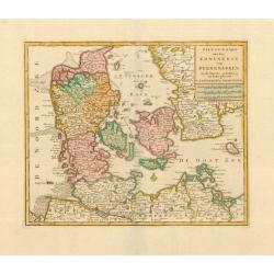
Nieuwe Kaart van het Koninkryk van Deenemarken. 1734.
Izaak Tirion (d. 1769) Amsterdam publisher. His ' Nieuwe en beknopte handatlas' saw 6 editions between before 1740 and after 1784. Also ' Tegenwoordige staat van alle vol...
Date: Amsterdam, c. 1750
Selling price: ????
Please login to see price!
Sold
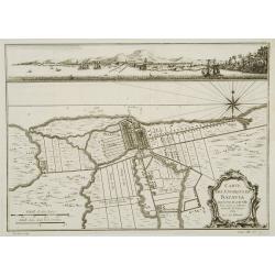
Carte des environs de Batavia avec la vuë de cette ville.
Map of Jakarta and surroundings with a separate view on top.From Prévost's important Collection of Voyages.
Date: Paris, 1750
Selling price: ????
Please login to see price!
Sold
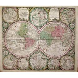
Diversi Globi Terr-Aquei, Statione Variante et Visu Intercendente
The magnificent, highly detailed world map from Seutter's set of world and continental maps features the world in two hemispheres, surrounded by windheads that recall 16t...
Date: Nuremberg 1750
Selling price: ????
Please login to see price!
Sold
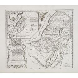
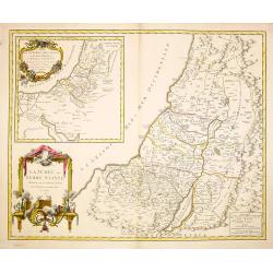
La monarchie des hébreux sous Salomon, ou le royaume d'Israël distingué en douze préfectures ou gouvernements / par le Sr. Moullart-Sanson. . .
Scarce map of Kingdom of Israel. Published by Pierre Moullart-Sanson, who was the grandson of Nicolas the elder.Very decorative title cartouche. On the upper left corner,...
Date: Paris, ca. 1750
Selling price: ????
Please login to see price!
Sold in 2015
Les Voiages de notre Seigneur Jesus Christ et des ..
Scarce map of the travels of Jesus, St Peter and St Paul. Published by Pierre Moullart-Sanson, who was the grandson of Nicolas the elder. Engraved by De la Haye.Very deco...
Date: Paris, ca. 1750
Selling price: ????
Please login to see price!
Sold in 2019
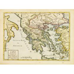
Carte de l'Ancienne Grece ..
Uncommon map of ancient Greece. For Introduction à l'Histoire Universelle du Baron de Puffendorf.
Date: Paris c.1750
Selling price: ????
Please login to see price!
Sold
Amerique meridionale pour servir à l'Histore Generale des Voyages.
Bellin's distinctive map of the continent, from Prevost d'Exiles' influential travel book, Histoire Générale des Voyages, features a charming decorative cartouche.
Date: Paris 1750
Selling price: ????
Please login to see price!
Sold
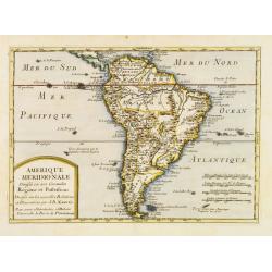
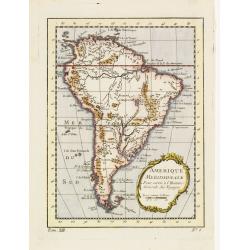
Amèrique Méridionale divisée en ses Grandes Régions et Possessions.
Uncommon map of South America after J.B.Nolin for Introduction à l'Histoire Universelle du Baron de Puffendorf.
Date: Paris c.1750
Selling price: ????
Please login to see price!
Sold