Browse Listings
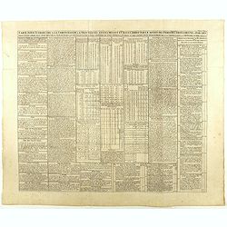
Carte pour introduire à la chronologie et à trouver les années devant et après Jésus Christ par le moyen des périodes Iulienne, Dionysienne et par les trois cycles comme aussi pour trouver la fête de Pasque. . .
An engraved table showing the years before and after Jesus Christ through the Julian and Gregorian calendars. Henri Abraham Chatelain (1684 – 1743) was a Huguenot pasto...
Date: Amsterdam, 1720-1732
Selling price: ????
Please login to see price!
Sold in 2020
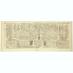
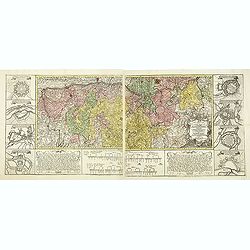
Carte genealogique des Ducs et Rois de Boheme et de Hongrie qui ont regné ou gouverné ces differents etats avec des instructions pour conduire à l'histoire de POLOGNE. . .
A genealogical tree of the Bohemian Duchess and Kings, from Chatelain's monumental 7 volume "Atlas Historique". This two sheet print features two small maps (11...
Date: Amsterdam, 1719-1732
Selling price: ????
Please login to see price!
Sold in 2018
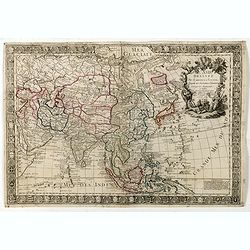
L'Asie dressée sur de nouveaux memoires Assujetis. . .
Decorative and separately issued map of Asia with engraved border composed of the coats of arms of Asian nations and is embellished with a large allegorical title cartouc...
Date: Paris, 1732
Selling price: ????
Please login to see price!
Sold in 2022
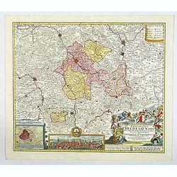
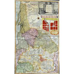
Episcopatus Hildesiensis nen non vicinorum Statuum delineatio Geographica. . .
Johann Baptist Homann's well-engraved map of the Bishopric of Hildesheim has a large decorative cartouche and a plan and profile inset of Hildesheim. The map has a tremen...
Date: Nuremberg 1732
Selling price: ????
Please login to see price!
Sold in 2020
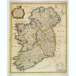
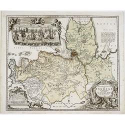
A Map of the Kingdom of Ireland.
A nice example of Seale's general map of Ireland produced for Tindal's "Continuation of Rapin's History." This map is quite detailed, accurate, and easy to read...
Date: London, ca 1732
Selling price: ????
Please login to see price!
Sold in 2019
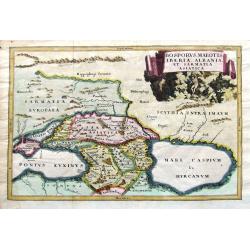
Bosporus, Maeotis, Iberia, Albania, et Sarmatia Asiatica.
An historical map of the Black Sea and the Caspian Sea, including todays Crimea, Armenia, Georgia, Azerbaijan, parts of Turkey and Russia. With cities, rivers, mountains,...
Date: Leipzig, 1732
Selling price: ????
Please login to see price!
Sold in 2019
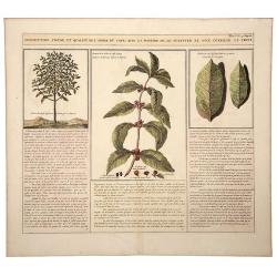
Description, Figure, et Qualite de L' Arbre du CAFÉ; Avec la Maniere de le Cultiver et d'en Cueiller le Fruit.
A large, old colored engraving showing the coffee plant and bean. Descriptive text in French below the images. Originates from: "Atlas Historique..." (Historic ...
Date: Amsterdam, 1732
Selling price: ????
Please login to see price!
Sold in 2020
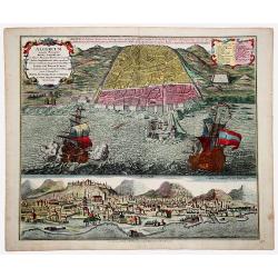
ALGERUM munita Metropolis REGNI ALGERIANI in littore Africano Barbariae in monte delici Amphitheatri instar quadrata forma... SEDES EST BASSAE TURCICI... (ALGIERS)
An impressive, originally colored sheet with two views of the town of Alger. A bird-eye view of the town and its harbor with two large galleons and a panoramic view, from...
Date: Ausburg 1732
Selling price: ????
Please login to see price!
Sold in 2021
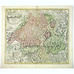
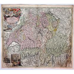
Potentissimae Helvetiorum Reipublicae Cantones Trediecim cum Foederatis et Subjectis Provinciis . . .
A wonderful map of Switzerland, showing the 13 Cantons, by Johann Baptiste Homann, head of one of the most prolific German map publishing houses of the entire 18th Centur...
Date: Nuremberg, 1732
Selling price: ????
Please login to see price!
Sold in 2019
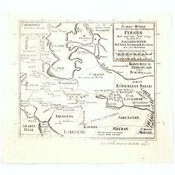
Schau-Buhne des Letzern Kriegs in dem Konigreich Persien. . .
Judasz Tadeusz Krusinski (1675 –1756) was a Polish Jesuit who lived in the Safavid Empire from 1707 to 1725/1728. He acted as an intermediary between the Papacy and the...
Date: Germany, ca 1732
Selling price: ????
Please login to see price!
Sold in 2020
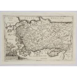
Asia Minore.
An interesting map of the region of Asia Minor originally by Cellarius in 1732. It features a decorative cartouche.Christoph (Keller) Cellarius (1638–1707) was a Germa...
Date: Venice, 1732
Selling price: ????
Please login to see price!
Sold in 2021
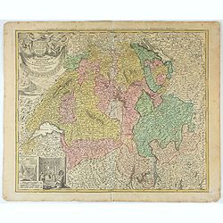
Potentissimae Helvetiorum Reipublicae Cantones Trediecim cum Foederatis et Subjectis Provinciis . . .
Detailed map of Switzerland, showing the 13 Cantons, by Johann Baptiste Homann, head of one of the most prolific German map publishing houses of the entire 18th Century. ...
Date: Nuremberg, 1732
Selling price: ????
Please login to see price!
Sold in 2025
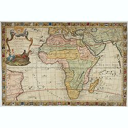
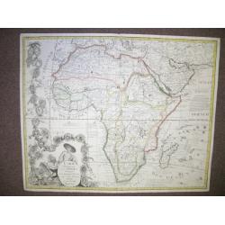
L'Afrique Dressée Sur les Relations et nouvelles decouvertes . . .
Decorative map of Africa with a large allegorical cartouche featuring a female Europe and a male Africa, both holding manacles, representing the valuable slaves trade...
Date: Paris, 1732
Selling price: ????
Please login to see price!
Sold in 2022
![[Recueil de Voyages au Nord].](/uploads/cache/48310-250x250.jpg)
[Recueil de Voyages au Nord].
Extract from volume III of the "Recueil de Voyages au Nord", containing the reports of Linschoten's voyages, the first to the North through the Strait of Nassau...
Date: Amsterdam, Bernard, 1732
Selling price: ????
Please login to see price!
Sold in 2022
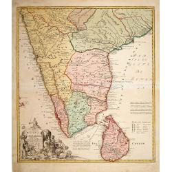
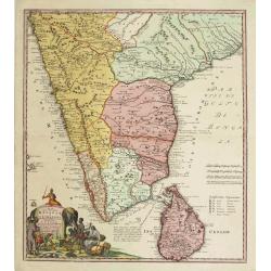
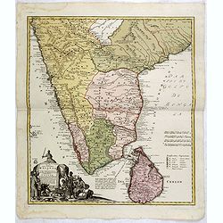
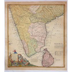
Peninsula Indiae Malabar Coromandel Ceylon.
Johann Baptist Homann's well-engraved map of southern India and Ceylon.Johann Baptist Homann (1663-1724) was a German engraver and publisher, who established himself and ...
Date: Nuremberg, 1733
Selling price: ????
Please login to see price!
Sold in 2020
A Map of the British Empire in America (Southeastern Section of Popple Map Sheet 10)
>A Map of the British Empire in America with the French, Spanish and the Dutch Settlements adjacent thereto. Henry Popple's Map of the British Empire in America ma...
Date: London, 1733
Selling price: ????
Please login to see price!
Sold in 2023
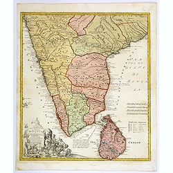
Peninsula Indiae Malabar Coromandel Ceylon.
Johann Baptist Homann's well-engraved map of southern India and Ceylon.Johann Baptist Homann (1663-1724) was a German engraver and publisher, who established himself and ...
Date: Nuremberg 1733
Selling price: ????
Please login to see price!
Sold
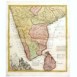
Peninsula Indiae Malabar Coromandel Ceylon.
Johann Baptist Homann's well-engraved map of southern India and Ceylon.Johann Baptist Homann (1663-1724) was a German engraver and publisher, who established himself and ...
Date: Nuremberg 1733
Selling price: ????
Please login to see price!
Sold
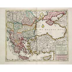
Nieuwe Kaart van Europisch Turkyen.
Izaak Tirion (d. 1769) Amsterdam publisher. His ' Nieuwe en beknopte handatlas' saw 6 editions between before 1740 and after 1784. Also ' Tegenwoordige staat van alle vol...
Date: Amsterdam, 1733
Selling price: ????
Please login to see price!
Sold
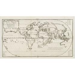
Mappe-monde pour servir a l'histoire des decouvertes et conquestes des Portugais dans le nouveau monde.
Oval world map showing some of the tracks of early Portuguese voyagers, prepared by Joseph Francois Lafitau (1681-1746), included in: "Histoire des decouvertes et co...
Date: Paris, 1733
Selling price: ????
Please login to see price!
Sold in 2008
Nouvelle Histoire Abregée de la Vie des Roys de France.
A listing of all the French Kings from 418 until 1715 from an Atlas Carte générale de la Monarchie Française 1730-1733 published by the French cartographer La Jaisse. ...
Date: Paris, 1733
Selling price: ????
Please login to see price!
Sold in 2009
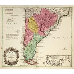
Typus Geographicus Chili Paraguay Freti Magellanici &c ?
An attractive map with much information and engraved notes. With inset map of the Strait of Magellan.
Date: Nuremberg, 1733
Selling price: ????
Please login to see price!
Sold in 2010
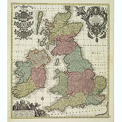
Tabula Novissima Accuratissima Regnorum Angliae, Scotiae, Hiberniae. . .
Decorative map of the British Isles, with 5 large coats of arms, portrait and two large decorative allegorical cartouches. The garlanded cartouche features a portrait of ...
Date: Augsburg, ca.1733
Selling price: ????
Please login to see price!
Sold in 2013
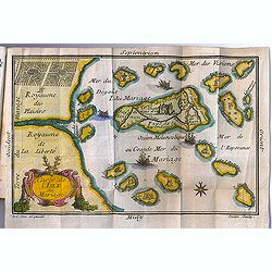
Carte de l'Isle du Mariage. (included in Almanach du Mariage Pour l'Année 1733
This guide book includes a very fine cartographic curiosity: "Carte de l'Isle du Mariage" (map of the wedding island.)Love and marriage have always been among t...
Date: Paris, C. Guillaume, 1733
Selling price: ????
Please login to see price!
Sold in 2012
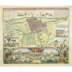
Der Hollaendisch-Ostindianischen Compagnie Weltberühmte Haupt - Handels und Niederlags stadt BATAVIA..
Very fine decorative town-plan of Batavia (Jakarta) showing the City and its immediate environs, the surrounding rice fields intersected by a network of waterways, canals...
Date: Nuremberg, 1733
Selling price: ????
Please login to see price!
Sold in 2012
Peninsula Indiae Malabar Coromandel Ceylon.
Johann Baptist Homann's well-engraved map of southern India and Ceylon. Colonial possessions are represented by little flags to which a lettered key has been added.Johann...
Date: Nuremberg 1733
Selling price: ????
Please login to see price!
Sold in 2015
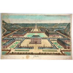
Glinike.
Striking print showing a panoramic view of Gliencke Palace just outside of Berlin, Germany. Published by Johann Georg Merz (1694-1762). Etched by Jean Baptiste Broebes (...
Date: Augsburg, 1733
Selling price: ????
Please login to see price!
Sold in 2016
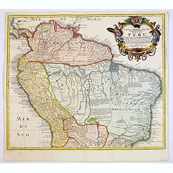
![Tabula Americae Specialis Geographica Regni Peru, Brasiliae, Terra Firmae & Reg: Amazonum, Secundum relationes de Herrera . . . [together with]](/uploads/cache/37397-250x250.jpg)
Tabula Americae Specialis Geographica Regni Peru, Brasiliae, Terra Firmae & Reg: Amazonum, Secundum relationes de Herrera . . . [together with]
A good and clean copy of Homann's map of the northern part of South America. The map is on the Valley of the Amazon and delineates the Amazon and its labyrinth of tributa...
Date: Nuremberg, 1733
Selling price: ????
Please login to see price!
Sold in 2016
![[JESUIT PARAGUAY], - PARAQUARIA in qua R.R. P.P Soc. Jesu suas Missiones promovere, 1733](/uploads/cache/98366-250x250.jpg)
[JESUIT PARAGUAY], - PARAQUARIA in qua R.R. P.P Soc. Jesu suas Missiones promovere, 1733
This map depicts the Jesuit missions in Paraguay and Uruguay with parts of Brazil, Bolivia, Argentina and Chile. The Parana and Paraguay Rivers are well defined, with the...
Date: Vienna, 1733
Selling price: ????
Please login to see price!
Sold in 2022
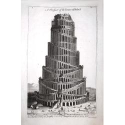
A Prospect of the Tower of Babel.
A Prospect of the Tower of Babel, engraved by J Mynde. The inscription beneath reads: To the right reverend Father in God John Lord Bishop of Oxford this plate is most hu...
Date: London, 1733
Selling price: ????
Please login to see price!
Sold in 2017
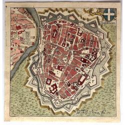
Stat Wienn.
Uncommon little bird's eye view of Vienna, Austria by Adam Desing in 1733. It features a decorative cartouche of the Austrian cross. Desing was an eighteenth century Bene...
Date: Ensdorf, 1733
Selling price: ????
Please login to see price!
Sold in 2018
Tabula Americae Specialis Geographica Regni Peru, Brasiliae, Terra Firmae & Reg: Amazonum, Secundum relationes de Herrera. . .
A good and clean copy of the top half of Homann's map of the northern part of South America. The map is on the Valley of the Amazon and delineates the Amazon and its laby...
Date: Nuremberg, 1733
Selling price: ????
Please login to see price!
Sold in 2017
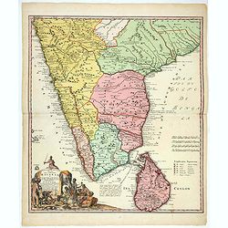
Peninsula Indiae Citra Gangem Hoc est Orae Celeberrimae Malabar & Coromandel...
A large and attractive map of Sri Lanka and the southern part of the Indian Peninsula, with an elaborate cartouche showing an elephant and elaborately clothed indigenous ...
Date: Nuremberg, 1733
Selling price: ????
Please login to see price!
Sold in 2018
Peninsula Indiae Malabar Coromandel Ceylon.
Johann Baptist Homann's well-engraved map of southern India and Ceylon.
Date: Nuremberg 1733
Selling price: ????
Please login to see price!
Sold in 2018
Peninsula Indiae Malabar Coromandel Ceylon.
Johann Baptist Homann's well-engraved map of southern India and Ceylon. This beautiful 1733 map of Southern India and Sri Lanka or Ceylon was issued by Homann Heirs. It i...
Date: Nuremberg 1733
Selling price: ????
Please login to see price!
Sold in 2020
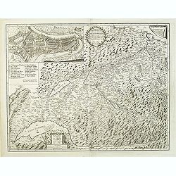
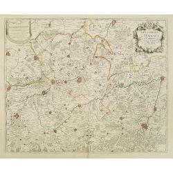
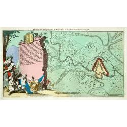
Carte géographique de la campagne du Haut Rhin pour l'année MDCCXXXIV contenant tous les mouvements marches et contremarches des armées. . .
Decorative map in two sheets of the center of Germany south of the River Rhine from Mainz to Kaisersthul. Including towns of Mainz, Frankfurt am Mains, Heidelberg, Heilbr...
Date: Nuremberg, ca. 1734
Selling price: ????
Please login to see price!
Sold in 2015
V. Haupt Karte America oder West Indien oder Die Neue Welt.
A rare map of America prepared by Anselm Desing (1699-1772) for "Historica auxilia". Printed by Christian Holstat Sulzbach for the publisher Johann Gastl.
Date: Regensburg, Johann Gastl, 1733 - 1734
Selling price: ????
Please login to see price!
Sold in 2014
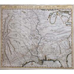
Carte de la Louisiane et du Cours du Mississipi.
Carte de la Louisiane et du Cours du Mississipi." From Jean Frederic Bernard's Recueil de Voiages au Nord. Amsterdam: J.F. Bernard, 1734.This is a reduced-size editi...
Date: Paris, 1734
Selling price: ????
Please login to see price!
Sold in 2016
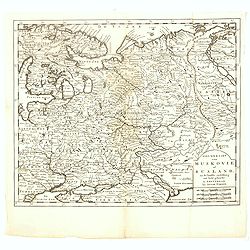
Nieuwe Kaart van Muskovie of Rusland.
Detailed map of European Russia, far south to the Black Sea and Caspian Sea. Isaac Tirion was born in Utrecht ca. 1705. He came to Amsterdam ca. 1725. Tirion published a ...
Date: Amsterdam, 1734
Selling price: ????
Please login to see price!
Sold in 2017
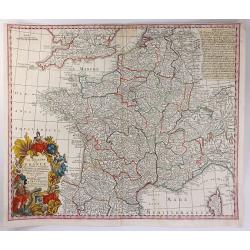
Le Royaume de France
A beautiful map of France, engraved with place names, mountains, rivers, lakes and more. It extends to include Corsica, portions of Spain, Italy, Helvetica and England. T...
Date: Augsburg, 1734
Selling price: ????
Please login to see price!
Sold in 2016
Plan de la baye et ville de Cadis, de la rivière de St. Lucas de Barameda, de ses environs.
Beautiful map of the city and bay of Cadiz, engraved by Le Tellier in 1734. Decorated with a title cartridge and several vignettes representing the forts and batteries of...
Date: Paris, 1734
Selling price: ????
Please login to see price!
Sold in 2017
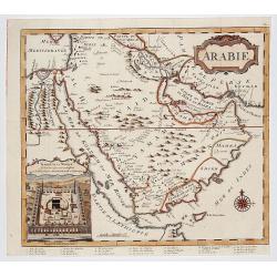
ARABIE . . .
Rare copperplate map of the Arabic peninsula with a view of the Kaaba / temple in Mecca in lower left corner. From the first edition of "The Koran, commonly called t...
Date: London, Charles Ackers for John Wilcox, 1734
Selling price: ????
Please login to see price!
Sold in 2017
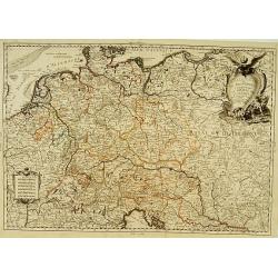
Circuli Supe Saxoniae pars Meridionalis sive Ducatus...
A detailed map of the region from Berlin in the north, to Prague in the southeast and Efurt in the west. It features a decorative cartouche including a small vignette of ...
Date: Neurenberg, 1734
Selling price: ????
Please login to see price!
Sold in 2018
Potentissimae Helvetorum Reipubliae Canones Tredecim cum Foederatis et Subjectis Provinciis.
A beautiful Homann map of Switzerland, showing the various religious enclaves. It features a large cartouche with the coats of arms of the cantons, four putti and flags. ...
Date: Neurenberg, 1734
Selling price: ????
Please login to see price!
Sold in 2017
Ingermanlandiae seu Ingriae novissima tabula luci tradita. . .
A detailed map with an imposing title cartouche and a panoramic view of St Petersburg. The region, known as Ingria, was annexed by Peter the Great in 1721 at the conclusi...
Date: Nurenberg, 1734
Selling price: ????
Please login to see price!
Sold in 2021
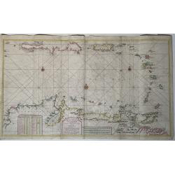
Nieuwe Paskaart van de Kusten van West Indien van Rio Oronoque tot Cartegena Met alle de Caribische Eylanden. . .
A superb large sea chart focusing on the eastern part of the Caribbean Sea, by J. Van Keulen after Jean Bertrand. The engraver was J.B. Stemmers. Printed on two sheets, j...
Date: Amsterdam, ca 1734
Selling price: ????
Please login to see price!
Sold in 2021
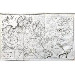
Royaume de Pologne
Rare copper engraved map of Poland, including parts of Lithuania, Latvia, Belarus and the Ukraine. It shows the area from Wroclaw until Moscow and the Black Sea. Names re...
Date: Paris, 1734
Selling price: ????
Please login to see price!
Sold in 2021
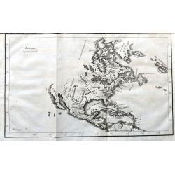
Amerique Septentrionale
A scarce copper engraving of colonial North America. The map shows the area from Greenland until the northern part of South America. Extends until California, but with la...
Date: Paris, 1734
Selling price: ????
Please login to see price!
Sold in 2021
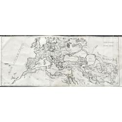
Carte Generale de L'Empire Romain.
Large and rare map of the Roman Empire. It shows the area from the Canary Islands until the Indus river. Including regions, some city names, lakes, rivers, and so on.Publ...
Date: Paris, 1734
Selling price: ????
Please login to see price!
Sold in 2021
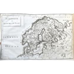
Scandinavie ou Royaumes du Nort.
Scarce map of Scandinavia and the Baltics. It shows the area from Denmark until Moscow, including parts of Poland. Names regions, some cities, lakes, rivers, and so on.Pu...
Date: Paris, 1734
Selling price: ????
Please login to see price!
Sold in 2021
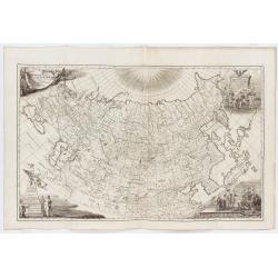
Imperii Russici tabula generalis quo ad fieri potuit / accuratissime descripta opera et studio Ioannis Kyrilow, …
General 1734 large-format map of the Russian Empire compiled by Ivan Kirilov (1689/1695]-1737), the Chief Secretary of the Governing Senate in St. Petersburg in 1734. ...
Date: Saint Petersburg : [Academy of Sciences], 1734
Selling price: ????
Please login to see price!
Sold in 2025
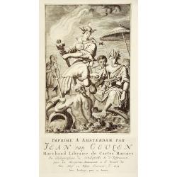
Title page
Stunning copper engraving showing Neptune with, Hercules, female representations of the continents. Below the engraving is the advertisement for van Keulen giving his pro...
Date: Amsterdam, 1734
Selling price: ????
Please login to see price!
Sold
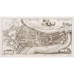
Berna Metropolis Nuithoniae.
An extremely rare plan of Bern after Jos Plepij and engraved by I.I.Turneijsens seel Wittib & Eerben.
Date: Basel, 1734
Selling price: ????
Please login to see price!
Sold in 2009
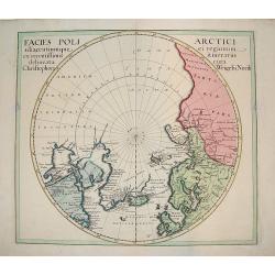
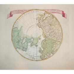
Facies Poli Artici adiacentiumque ei regionum ex recentissimis itirnerariis delineata cura Christophori Weigelii, Norib
An uncommon polar chart that labels present-day northwestern America AMERICA SEPTENTRIONALIA INCOGNITA does not show a western coast. There is good detail of the northern...
Date: ca 1734
Selling price: ????
Please login to see price!
Sold
Inclytae Urbis et Ditionis BERNENSIS cum locis finidimis Tabula Geographica et Hydrographica noviter correcta.
Map centered on Bern. Inset: a bird-eye view of the city.VERY RARE!
Date: Basle, 1734
Selling price: ????
Please login to see price!
Sold
![[Title page]](/uploads/cache/24965-250x250.jpg)
[Title page]
Stunning copper engraving showing Neptune with, Hercules, female representations of the continents. Below the engraving is the advertisement in French for Joannes van Keu...
Date: Amsterdam, 1734
Selling price: ????
Please login to see price!
Sold in 2008
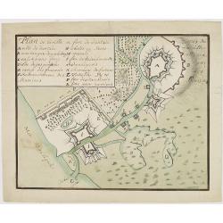
Plan de la ville er fort de Dantzie.
A charming manuscript town-plan of Dantzig, showing the siege of 1734, with a lettered key in upper left corner. The French (E), Russian (F) and Danish (P) positions are ...
Date: Circa, 1734
Selling price: ????
Please login to see price!
Sold in 2013
Les Comtez de Hainaut, de Cambresis, et Partie du Comté de Namur..
Uncommon map showing southern Belgium provinces south of Brussels and published by Crepy.Including the towns of Lille, Brussels, Namen, Dinant, Cambray, Mons, etc.
Date: Paris, 1735
Selling price: ????
Please login to see price!
Sold in 2015
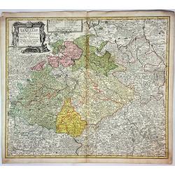
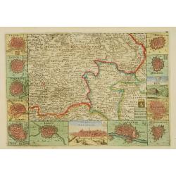
Potentissimo Borussorum Regi Friderico Wilhelmo...
Large and sought-after 2-sheet map of an area of Lithuania and Eastern Prussia (Russian province of Kaliningrad) stretching from Klaipeda (Memel) in the north to Goldap i...
Date: Nuremberg, 1735
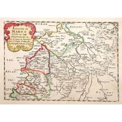
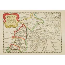
Royaume de Maroc divise en sept Provinces..
Attractive map of Morocco prepared by Daniel de La Feuille (1702) and published in the rare first edition of "Kleyne en Beknopte Atlas, of Tooneel des Oorlogs in Eur...
Date: Amsterdam 1735
Selling price: ????
Please login to see price!
Sold

Kaart van 't graafschap Henegouwen.
Attractive map centred on the province of Cambrai and Mons, including two views of Mons and Valenciennes. Prepared by Daniel de La Feuille (1702) published in the rare fi...
Date: Amsterdam 1735
Selling price: ????
Please login to see price!
Sold
![Mons. [2 prints]](/uploads/cache/12979-250x250.jpg)
Mons. [2 prints]
Attractive birds-eye-view of the town of Mons and a map of the battle of 1709 in the area Mons and Maubeuge, with two fighting figures on the right side. Prepared by Dani...
Date: Amsterdam 1735
Selling price: ????
Please login to see price!
Sold
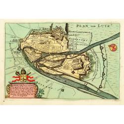
Luik.
An attractive birds-eye-view of the town of Liege, prepared by Daniel de La Feuille (1702) published in the rare first edition of "Kleyne en Beknopte Atlas, of Toone...
Date: Amsterdam 1735
Selling price: ????
Please login to see price!
Sold
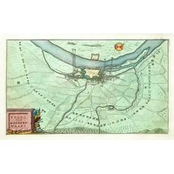
Beleg van Keizerswaart.
An attractive birds-eye-view of the siege of Keizersweert, published in the rare first edition of "Kleyne en Beknopte Atlas, of Tooneel des Oorlogs in Europa.."...
Date: Amsterdam 1735
Selling price: ????
Please login to see price!
Sold
Afbeelding der Battalje .. Moscoviters en de Turken ..
An attractive birds-eye-view from the battle between Russians and Turkish, published in the rare first edition of "Kleyne en Beknopte Atlas, of Tooneel des Oorlogs i...
Date: Amsterdam 1735
Selling price: ????
Please login to see price!
Sold
![Kings of Brabant. [2 maps]](/uploads/cache/13016-250x250.jpg)
Kings of Brabant. [2 maps]
Two attractive engravings of the Brabant Dukes, from Tassandre the First till Philip V, published in the rare first edition of "Kleyne en Beknopte Atlas, of Tooneel ...
Date: Amsterdam 1735
Selling price: ????
Please login to see price!
Sold
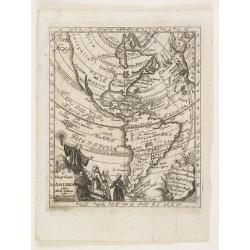
Amérique les Francois possedent en cette partie le Canada..
Very rare separately published map of America, showing California as an island. California's insularity indefinite: Cape Blanc de S.Sebastien is labelled at its north end...
Date: Paris 1735
Selling price: ????
Please login to see price!
Sold
Nieuwe Kaart van de Noord Pool.
A first state example. Highly attractive map of northern polar projection. The Pacific region is completely blank, with good detail in Europe and Asia. In China, the grea...
Date: Amsterdam 1735
Selling price: ????
Please login to see price!
Sold in 2009
BRUZEN DE LA MARTINIERE: Introduction a l'histoire de l'Asie de l'Afrique et de l'Amérique.
Volume 2 (of 2) of his "Introduction a l'histoire de l'Asie de l'Afrique et de l'Amérique", complete with map of America, including a California as a island.Th...
Date: Amsterdam, Zacharie Chatelain, 1735
Selling price: ????
Please login to see price!
Sold in 2021
L\'Allemagne et ses Frontières, comprenant le théatre de la Guerre..
An uncommon map of Germany, including, Poland, Low Countries, Switzerland, Austria and Northern part of Italy.
Date: Paris, 1735
Selling price: ????
Please login to see price!
Sold in 2008
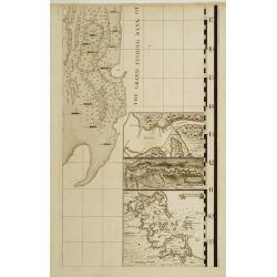
Sheet 8 of 20: The harbour of Placentia./ The harbour of Anapolis Royal./ Boston Harbor.
One sheet of H.Popple's twenty-sheet survey of North America, in a first stae, the first large-scale map of the British colonies in America. Shows part of the Grand Fishi...
Date: London 1733-1735
Selling price: ????
Please login to see price!
Sold
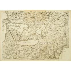
Sheet 6 of 20: The Great Lakes and New Jersey.
One sheet of H.Popple's twenty-sheet survey of North America, in a first state, the first large-scale map of the British colonies in America. Featuring the Great Lakes in...
Date: London 1733-1735
Selling price: ????
Please login to see price!
Sold
Sheet 5 of 20: The Mississippi River system and its tributaries.
One sheet of H.Popple's twenty-sheet survey of North America, in a first stae, the first large-scale map of the British colonies in America. Featuring the Great Lakes in ...
Date: London 1733-1735
Selling price: ????
Please login to see price!
Sold
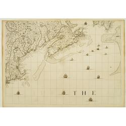
One sheet of 20: The coast from NovaScotia to Cape Cod and Nantucket.
One sheet of H.Popple's twenty-sheet survey of North America, in a first stae, the first large-scale map of the British colonies in America. Featuring the coast from Nova...
Date: London 1733-1735
Selling price: ????
Please login to see price!
Sold
Carte générale de l'Afrique contenant les principaux états dressée sur les nouvelles observations?
Charles Inselin (or Inslin) was an engraver for important map publishers such as Delisle, de Fer and Jaillot in Paris during the first half of the 18th century. His map ...
Date: Paris, 1735
Selling price: ????
Please login to see price!
Sold
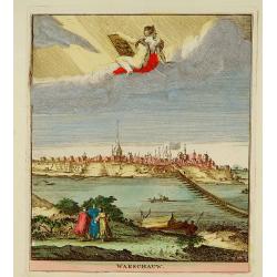
Warschauw
Attractive panoramic view of Warschau and published in the rare first edition of Kleyne en Beknopte Atlas, of Tooneel des Oorlogs in Europa.. .The atlas was published by ...
Date: Amsterdam, 1735
Selling price: ????
Please login to see price!
Sold
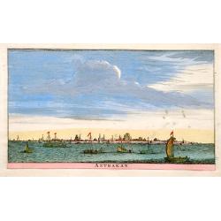
Astrakan.
An attractive panoramic view of Astrakan in Russia. Published in the rare first edition of Kleyne en Beknopte Atlas, of Tooneel des Oorlogs in Europa..The atlas was publ...
Date: Amsterdam 1735
Selling price: ????
Please login to see price!
Sold
Kaart van't Hertogdom Brabant.
Attractive map centered on the province of Brabant, including the maps of Venlo, Leuven, Roermond, Namur, Liege, Leeuw, Breda, Mechelen, Maastricht, s'Hertogenbosch, Antw...
Date: Amsterdam 1735
Selling price: ????
Please login to see price!
Sold
Royaume de Maroc divise en sept Provinces..
Attractive map of Morocco prepared by Daniel de La Feuille (1702) and published in the rare first edition of ,Kleyne en Beknopte Atlas, of Tooneel des Oorlogs in Europa.....
Date: Amsterdam 1735
Selling price: ????
Please login to see price!
Sold
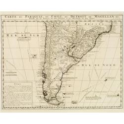
Carte du Paraguai, du Chili, du Detroit de Magellan &c..
Large, finely engraved map of the southern part of South America with great topographical detail and notations throughout.The tracks of several explorations are noted in ...
Date: Amsterdam 1720-1735
Selling price: ????
Please login to see price!
Sold in 2008