Browse Listings
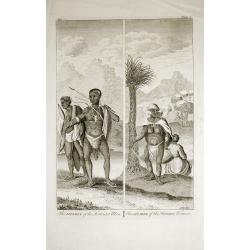
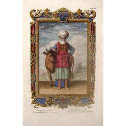
The Apparel of the Hottentot Men - The Apparel of the Hottentot Women.
An early 1731 engraving depicting the apparel of the Hottentot people of South Africa.James Mynde Engraver, working in City of London on general plates. He had a large st...
Date: London, 1731
Selling price: ????
Please login to see price!
Sold in 2012
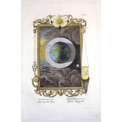
Opus Quartae Diei.
Striking copper engraved print depicting the fourth day of creation. Features the Eastern hemisphere in the print and the sun in the very ornate frame. engraved by I.A. F...
Date: Augsburg, 1731
Selling price: ????
Please login to see price!
Sold in 2014
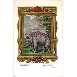
Reem, Rhinoceros.
Rare copper engraved print of Reem. Rhinoceros, though to be copied from Duerer's Rhino. Engraved by I.G. Pinz for Johann Scheuchzer's Physica Sacra.Johannes Jacob Scheuc...
Date: Augsburg, 1731
Selling price: ????
Please login to see price!
Sold in 2015
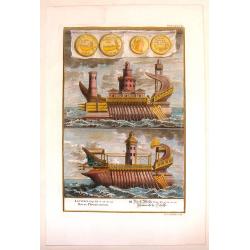
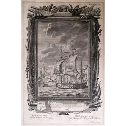
Phoenecian Navy.
A hand-colored copperplate print featuring two splendid ships from the Phoenician navy. Sedlezki engraved them. Interesting drapery cartouche with four Phoenecian coins.J...
Date: Augsburg, 1731
Selling price: ????
Please login to see price!
Sold in 2013
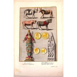
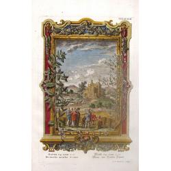
Egyptian Antiquities.
Interesting hand-colored copperplate print featuring items of Egyptian antiquities. Engraved by G.D. Heuman. Johannes Jacob Scheuchzer (1672-1733) is known as the the fo...
Date: Augsberg, 1731
Selling price: ????
Please login to see price!
Sold in 2015
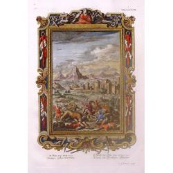
Pharaoh's Dream.
Ornate hand-colored copper engraved print featuring Pharaoh's dream. Behind him is a fictitious Egyptian city of his dream. The engraver was M. Tyroff.Johannes Jacob Sche...
Date: Augsburg, 1731
Selling price: ????
Please login to see price!
Sold in 2016
Navis bellica es maximis / Engl. Kriegs=Schiff vom ersten Rang.
A fine and very rare display of English sailing war ships. Superb print from Johann Jakob Scheuchzer, engraved by Johann Georg Pintz.Highly decorative.
Date: Zurich?, c1731
Selling price: ????
Please login to see price!
Sold in 2020
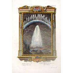
Aurora Borealis.
Rare hand-colored, copper engraved print from Johann Scheuchzer's Physica Sacra published in Augsburg in 1731.Johannes Jacob Scheuchzer (1672-1733) is known as the the fo...
Date: Augsburg, 1731
Selling price: ????
Please login to see price!
Sold in 2015
Garments of the High Priests.
Scarce hand-colored, copper engraved print from Johann Scheuchzer's Physica Sacra published in Augsburg in 1731.Johannes Jacob Scheuchzer (1672-1733) is known as the the ...
Date: Augsburg, 1731
Selling price: ????
Please login to see price!
Sold in 2014
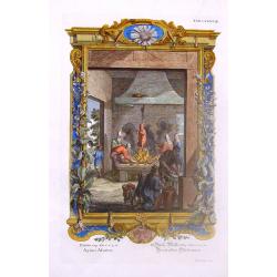
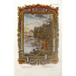
Roasting the Meat.
Copper engraved print from Johann Scheuchzer's 'Physica Sacra', published in Augsburg in 1731.Johannes Jacob Scheuchzer (1672-1733) is known as the founder of paleobotany...
Date: Augsburg, 1731
Selling price: ????
Please login to see price!
Sold in 2019
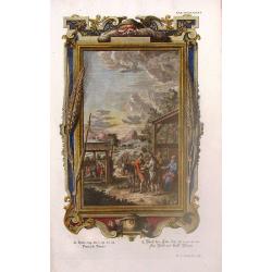
Man From Baalshalisha Delivering Bread.
Scarce hand-colored, copper engraved print from Johann Scheuchzer's 'Physica Sacra' published in Augsburg in 1731.Johannes Jacob Scheuchzer (1672-1733) is the founder of ...
Date: Augsburg, 1731
Selling price: ????
Please login to see price!
Sold in 2020
Hezekiah Asks Isaiah - What Will Be the Sign?
Copper engraved print from Johann Scheuchzer's Physica Sacra, published in Augsburg in 1731. Johannes Jacob Scheuchzer (1672-1733) is known as the the founder of paleobo...
Date: Augsburg, 1731
Selling price: ????
Please login to see price!
Sold in 2019

Jezebel at the Mirror.
Scarce hand-colored, copper engraved print from Johann Scheuchzer's Physica Sacra, published in Augsburg in 1731. Johannes Jacob Scheuchzer (1672-1733) is known as the t...
Date: Augsburg, 1731
Selling price: ????
Please login to see price!
Sold in 2016
The Lions Came To Eat Them.
Scarce hand-colored, copper engraved print from Johann Scheuchzer's Physica Sacra, published in Augsburg in 1731. Johannes Jacob Scheuchzer (1672-1733) is known as the t...
Date: Augsburg, 1731
Selling price: ????
Please login to see price!
Sold in 2018
Man Drops Borrowed Axe Head Into the Water.
Scarce hand-colored, copper engraved print from Johann Scheuchzer's Physica Sacra published in Augsburg in 1731.Johannes Jacob Scheuchzer (1672-1733) is known as the the ...
Date: Augsburg, 1731
Selling price: ????
Please login to see price!
Sold in 2015
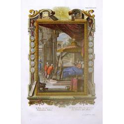
Elisha Got Up From His Grave.
Copper engraved print from Johann Scheuchzer's Physica Sacra, published in Augsburg in 1731. Johannes Jacob Scheuchzer (1672-1733) is known as the the founder of paleobo...
Date: Augsburg, 1731
Selling price: ????
Please login to see price!
Sold in 2020
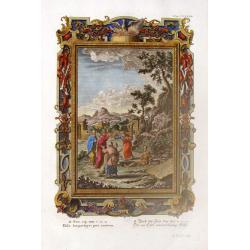
Paying Tithes of Mint, Anise & Cummin.
Copper engraved print from Johann Scheuchzer's 'Physica Sacra', published in Augsburg in 1731.Johannes Jacob Scheuchzer (1672-1733) is best known as the founder of paleob...
Date: Augsburg, 1731
Selling price: ????
Please login to see price!
Sold in 2018
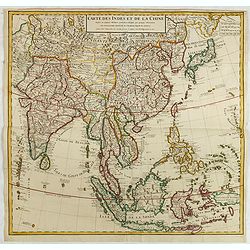
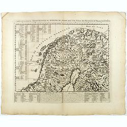
Carte des Indes et de la Chine..
Early edition of this large and attractive map of South East Asia, India, Japan, Korea and China.The map is of interest for the use of Mer Orientale ou Mer de Corée, for...
Date: Paris, 1731
Selling price: ????
Please login to see price!
Sold in 2015
Pianta della città di Firenze nelle sue vere misure colla descrizione dei luoghi più notabili di ciascun quartiere.
First edition of the plan of the city of Florence by Ferdinando Ruggieri. Decorated with a title cartridge, a dedication cartouche decorated with the coat of arms of the ...
Date: Florence, 1731
Selling price: ????
Please login to see price!
Sold in 2017
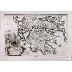
Hellas siue Graecia Propria.
A pleasant map of Southern Greece, portraying the ancient geography and cities, including the Pelopenesos, Athens, Corinth, Thebes, Argos, Mycenae and Sparta. With decora...
Date: Leipzig, 1731
Selling price: ????
Please login to see price!
Sold in 2018

The Present State of the Cape of Good-Hope: or a Particular Account of the Several Nations of the Hottentots...
One of the most important early accounts of South Africa and the Cape of Good Hope! “It contains the earliest list of South African animals … a full account of the go...
Date: London, 1731
Selling price: ????
Please login to see price!
Sold in 2019
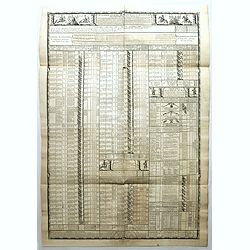
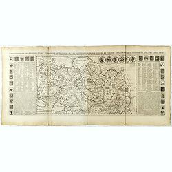
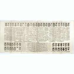
Cavalerie legere françoise et etrangere régimentée sous Louis XIII en 1635. Neuviémz feuille.
Table showing the structure of The regiment of the Kings Cavalry which was a regiment of the cavalry of the Kingdom of France created in 1635 (then regiment of dragons). ...
Date: Paris, ca. 1731
Selling price: ????
Please login to see price!
Sold in 2019
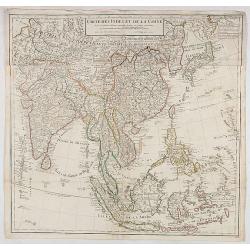
Carte des Indes et de la Chine. . .
Early edition of this large and attractive map of South East Asia, India, Japan, Korea and China.The map is of interest for the use of Mer Orientale ou Mer de Corée, for...
Date: Paris, 1731
Selling price: ????
Please login to see price!
Sold in 2020
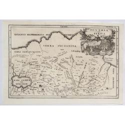
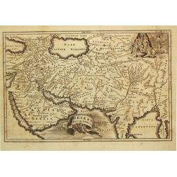
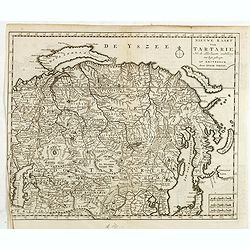
Scythia et Serica.
An interesting map of the region between the Caspian Sea and the Sea of China, much of which is 'Terra Incognita' in the North and East. Based upon 2000 year old geograph...
Date: Amsterdam, 1731
Selling price: ????
Please login to see price!
Sold in 2023
Sarmatda.
An interesting map of the Crimean Peninsula in Russia originally by Cellarius in 1731. It features a fine decorative cartouche with nomad peoples of the region. Christop...
Date: Venice, 1731
Selling price: ????
Please login to see price!
Sold in 2021
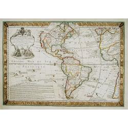
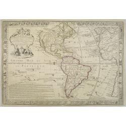
L'AMERIQUE Meridionale et Septentrionale Dressée sur les Nou
Map surrounded by portraits of the New World explorers and those on either side are illuminated with charming illustrations of the signs of the zodiac.Geographically, the...
Date: Paris, 1731
Selling price: ????
Please login to see price!
Sold
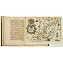
Delineatis Pennsylvaniae et Caesereae nov. Occidebt seu West Niersey in America.
An extremely rare map of Pensylvania and New Jersey engraved by Jonas Silfverlong. Published in a publication by Tobias Biorck titled Dissertatio Gradualis, de Plantation...
Date: Upsula 1731
Selling price: ????
Please login to see price!
Sold
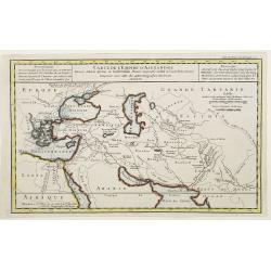
Carte de l'Empire d'Alexandre dressée Selon le Systeme de Guill. Delisle..
Fine map showing the territory conquered by Alexander the Great.
Date: Paris 1731
Selling price: ????
Please login to see price!
Sold
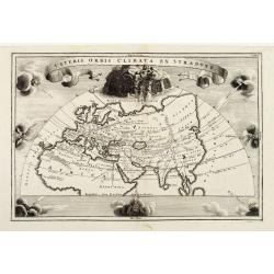
Veteris Orbis Climata Ex Strabone..
Old World climates according to Strabo. Europe, Asia, and northern Africa are surrounded by eight compass points worth of wind heads. Of particular interest is 'Aquilo,' ...
Date: Leipzig 1731
Selling price: ????
Please login to see price!
Sold
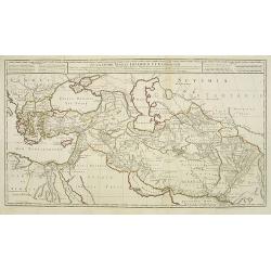
Alexandri Magni Imperium et Expeditio..
Uncommon map of the Empire and travels of Alexander the Great. .The map is printed from two sheets.
Date: Paris, 1731
Selling price: ????
Please login to see price!
Sold in 2009
L\'AMERIQUE Meridionale et Septentrionale Dressée sur?
Map surrounded by portraits of the New World explorers and those on either side are illuminated with charming illustrations of the signs of the zodiac.Geographically, the...
Date: Paris, 1731
Selling price: ????
Please login to see price!
Sold in 2009
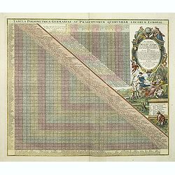
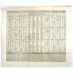
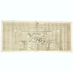
Tabula Poliometrica Germaniae ac Praecipuorum Quorundam Locorum Europae. Neu vermehrter curioser Meilen-Zeiger der vornehmsten Staedte in Europa besonders. . .
Decorative table of distances between major European cities, dated 1731. In the 18th century this type of distance tables where useful for calculating the cost for sendin...
Date: Nuremberg, after 1731
Selling price: ????
Please login to see price!
Sold in 2011
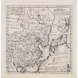
The Empire of China and Island of Japan, Agreeable to Modern History by H.Moll.
Map of China, Korea, Japan, the island Taiwan (Formosa I.). The map is of interest for the use of East Sea, the sea between Korea and Japan, here called "Sea of Core...
Date: London, Thos. Bowles and John Bowles, 1729-1732
Selling price: ????
Please login to see price!
Sold
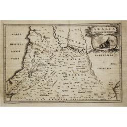
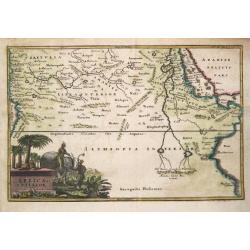
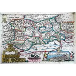
Arabia Petraea et Deserta.
Christoph Cellarius (1638-1707). Geographia Antiqua, 1686
Date: Leipzig, Gledisch, 1732
Selling price: ????
Please login to see price!
Sold
Oriens, Persia, India etc.
Christoph Cellarius (1638-1707). Geographia Antiqua, 1686
Date: Leipzig, Gledisch, 1732
Selling price: ????
Please login to see price!
Sold
Africa Interior.
Christoph Cellarius (1638-1707). Geographia Antiqua, 1686
Date: Leipzig, Gledisch, 1732
Selling price: ????
Please login to see price!
Sold in 2019
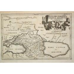
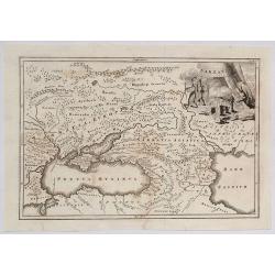
Bosporus, Maeotis, Iberia, Albania et Sarmatica Asiatica
Christoph Cellarius (1638-1707). Geographia Antiqua, 1686. A map of the Black Sea, the Caspium Sea and the area between. Embellished with a nice title-cartouche.
Date: Leipzig, Gledisch, 1732
Selling price: ????
Please login to see price!
Sold in 2009
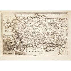
Asia Minor.
Christoph Cellarius (1638-1707). Geographia Antiqua, 1686.A map of Turkey and Cyprus. Embellished with a nice title-cartouche.
Date: Leipzig, Gledisch, 1732
Selling price: ????
Please login to see price!
Sold in 2008
![[untitled] coastal views of Corsica and Porto Venere, Italy.](/uploads/cache/92545-250x250.jpg)
[untitled] coastal views of Corsica and Porto Venere, Italy.
Unusual sheet with 20 sections of coastal views/land profiles of Italy and Corsica. Shows Porto Venere, Bastia, Calvi, and parts along the route. Each section with inform...
Date: Marseille, c1732
Selling price: ????
Please login to see price!
Sold in 2013
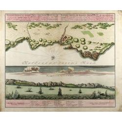
Wahrhaffte Abbildung der Barbarischen Vestung Oran
Hand colored copper engraving from Chr. Gephart by Homann Heirs, showing coast outline of Algeria (province Oran) and some sailing ships.
Date: Nuremberg, 1732
Selling price: ????
Please login to see price!
Sold in 2008
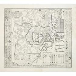
Plan de Jedo.. / Beschrijving van de stad JEDO..
The old Imperial capital, centered on the palace compound is shown in this detailed plan, based on Japanese printed plans of the late seventeenth century. From Kaempfer's...
Date: The Hague, 1732
Selling price: ????
Please login to see price!
Sold in 2008
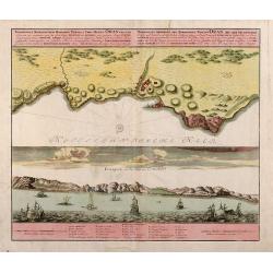
Topographica Repraesentatio Barbarici Portus et Urbis Munitae Oran / Wahrhaffte Abbildung der Barbarischen Vestung Oran
Original old colored copper engraved map from Chr. Gephart by Homann Heirs published 1732 in Nuremberg. Showing the coast outline of Algeria (province Oran) on the upper ...
Date: Nuremberg, 1732
Selling price: ????
Please login to see price!
Sold in 2013
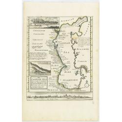
The Caspian Sea Drawn by the Czar's special command By Carl van Verden in the year 1719. 1720 and 1721. . .
Hand col. engraved map with 3 inset views. Includes geographical notes.With views of "Terky", "Derbent" and "Astracan"
Date: London, 1732
Selling price: ????
Please login to see price!
Sold in 2011
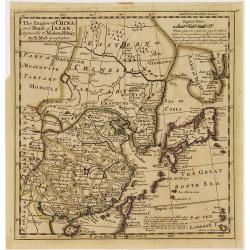
The Empire of China and Island of Japan, Agreeable to Modern History by H.Moll.
Map of China, Korea, Japan, the island Taiwan (Formosa I.). The map is of interest for the use of East Sea, the sea between Korea and Japan, here called "Sea of Kore...
Date: London, Thos. Bowles and John Bowles, 1729-1732
Selling price: ????
Please login to see price!
Sold in 2010
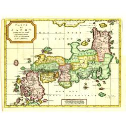
Carte du Japon, Dressée sur les Cartes Japonnoises. . .
Japan is still drawn in a nearly purely east-west position. At bottom right at the island of Fatsisio is mentioned: To this island the powerful men of Japan were sent Int...
Date: The Hague, 1732
Selling price: ????
Please login to see price!
Sold in 2019
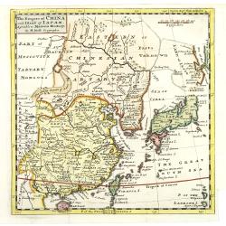
The Empire of China and Island of Japan, Agreeable to Modern History by H.Moll.
With page number 1 added in upper right corner of the scale. Map of China, Korea, Japan, the island Taiwan (Formosa I.). The map is of interest for the use of East Sea, t...
Date: London, Thos. Bowles and John Bowles, 1729-1732
Selling price: ????
Please login to see price!
Sold
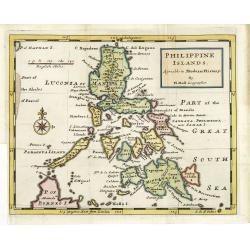
Philippine islands Agreable to Modern History. . .
Map of the Philippines, with insets of Manila, Manila vicinity, Borneo. . .
Date: London, c. 1732
Selling price: ????
Please login to see price!
Sold in 2011
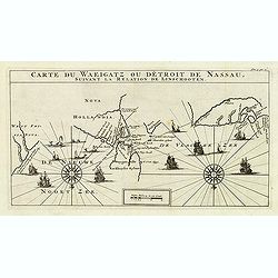
Carte Du Waeigatz ou Detroit De Nassau Suivant la Relation De Linschooten.
Decorative map of the Waeigatz Straits, between the southern part of Nova Zembla and the country of Samoyeds. Including two compass roses with radiating rhumb lines and v...
Date: Amsterdam, 1732
Selling price: ????
Please login to see price!
Sold in 2012
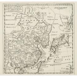
The Empire of China and Island of Japan, Agreeable to Modern History by H.Moll.
With page number 1 added in upper right corner of the scale. Map of China, Korea, Japan, the island Taiwan (Formosa I.). The map is of interest for the use of East Sea, t...
Date: London, Thos. Bowles and John Bowles, 1729-1732
Selling price: ????
Please login to see price!
Sold
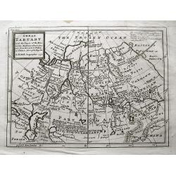
Great Tartary. With the Tract of the Moscovite Ambassadox\'s Travels from Moscow to Pekin. . .
Interesting map illustrating the route taken by the Russian Ambassador on his travels to Beijing. Showing the Great Wall, "Somer Houses" and "parts unknow...
Date: London, 1732
Selling price: ????
Please login to see price!
Sold in 2013
Plan de L'Isle Galita
Beautifully engraved map of the Island of Galite, north of Tunisia. Decorated with a large compass rose. Little is known about Jacques Ayrouard and he only published thi...
Date: Paris, 1732
Selling price: ????
Please login to see price!
Sold in 2014
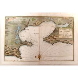
Plan de la Baye de Loristan
Nautical chart of the Gulf of Oristano in Sardinia. Decorated with a formidable compass rose, pointing due left. Little is known about Jacques Ayrouard and he only publi...
Date: Paris, 1732
Selling price: ????
Please login to see price!
Sold in 2014
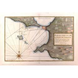
Plan du Port et de la Baye de Tarante
Nautical chart of the Gulf and Port of Taranto in Italy. Imposing large compass rose. Little is known about Jacques Ayrouard and he only published this single book on the...
Date: Paris, 1732
Selling price: ????
Please login to see price!
Sold in 2016
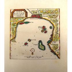
La Rade de Bantam.
Map of the Bay of Bantam on Java. Decorated with a frame cartouche. Pieter van der Aa (1659 - 1733) was a Dutch publisher best known for preparing maps and atlases. He a...
Date: Amsterdam, 1732
Selling price: ????
Please login to see price!
Sold in 2014
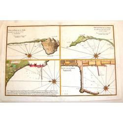
Plan du Mole de Naples, Veue en Plan de la Rade.
Four plans on one page of harbors on the Tyrrhenian Seacoast of Italy. Includes the harbors of Naples & Pozzuoli. The fortifications and buildings are well shown. Eac...
Date: Paris, 1732
Selling price: ????
Please login to see price!
Sold in 2014
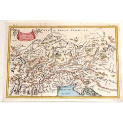
The Countries of Vindelicia, Rhaetia & Noricum.
Finely copper engraved map of ancient Switzerland, Germany, Austria, italy and Hungary. Interesting drapery style title cartouche held in the air by a pair of putti. Chri...
Date: London, 1732
Selling price: ????
Please login to see price!
Sold in 2015
Charta, in qua eruditis spectanda exhibetur pars Asiae. . .
Map of the area east of the Caspian Sea,the Lake Aral is shown almost in centre of map. The map shows parts of Kazakhstan, Turkmenistan, Uzbekistan and Kirgistan. The map...
Date: London, 1732
Selling price: ????
Please login to see price!
Sold in 2013
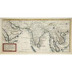
A map of the continent of the East-Indies &c. Containing the territories, settlements, and factories of the Europeans. Explaining what belongs to England, France, Holland, Denmark, Portugal &c. By H. Moll Geographer. Printed and sold by T. Bowles next ye
Map of the Continent of the East-Indies &c. Containing the Territories, Settlements, and Factories of the Europeans. Explaining what belongs to England, France, Holla...
Date: London, 1732
Selling price: ????
Please login to see price!
Sold in 2014
Caarte van Neufchatel et Valangin.
Highly detailed and decorative copper engraved map, showing the Lake Neuchâtel and surrounding area. Richly embellished with sailing ships on the lake, the title carto...
Date: Amsterdam, 1732
Selling price: ????
Please login to see price!
Sold in 2013
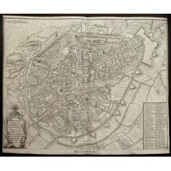
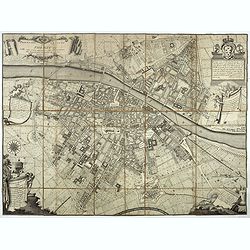
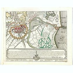
(Double page plan of Brussels)
Striking and highly detailed copper engraved city plan of Brussels, by Isaac Basire. For Mr. Tindal's Continuation of Mr. Rapin's History. This plan depicts roads, waterw...
Date: London, 1732
Selling price: ????
Please login to see price!
Sold in 2014
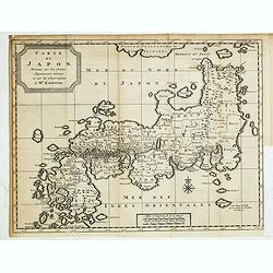
Carte du Japon, Dressée sur les Cartes Japonnoises. . .
Japan is still drawn in a nearly purely east-west position. At bottom right at the island of Fatsisio is mentioned: To this island the powerful men of Japan were sent Int...
Date: The Hague, 1732
Selling price: ????
Please login to see price!
Sold in 2014
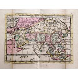
Asia la Feuille Exc.
Charming and unusual map of Asia, published by J. Ratelband. Includes several misshaped coast lines and distorted islands. Coloring indicating kingdoms and areas. A small...
Date: Amsterdam, c1732
Selling price: ????
Please login to see price!
Sold in 2014
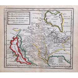
The Isle of California, New Mexico, Louisiane, The River Misisipi and the Lakes of Canada.
Printed in London, 1732. From Herman Moll's "A System of Geography." A scarce and remarkable map of California.California is as an island, with over a dozen pla...
Date: London, 1732
Selling price: ????
Please login to see price!
Sold in 2014
Nieuwe kaart Tartarie Na de adderlaaste ondekking int ligt gebragt. . .
Map of Siberia , Novaya Zemlya , China, Korea and part of Japan with the legendary "Compagnie Land".
Date: Amsterdam, 1732
Selling price: ????
Please login to see price!
Sold in 2019
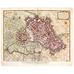
Plan of the City and Citadel of Lisle. (Lille)
Detailed city plan of the city and citadel of Lille in northern France. It is from Mr. Tindal's continuation of Mr. Tindal's "HISTORY OF ENGLAND" published in L...
Date: London, 1732
Selling price: ????
Please login to see price!
Sold in 2020
![Etat abregé de la Maison du Grand Seigneur. . . [Views of Constantinople]](/uploads/cache/36516-250x250.jpg)
Etat abregé de la Maison du Grand Seigneur. . . [Views of Constantinople]
This impressive engraving is a wonderful example of Chatelain’s elegant plates. Ornamented with 3 vignettes: Vuë du Serrail de Constantinople, Vuë de Constantinople, ...
Date: Amsterdam, ca. 1732
Selling price: ????
Please login to see price!
Sold in 2015
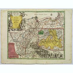
Carte générale des états du Czar Empereur de Moscovie ou l'on voit . . .
General map of Russia of the states of the Czar Emperor of Muscovy showing his possessions in Europe and Asia. To the left and right explanatory panels with coats of arms...
Date: Amsterdam, ca. 1732
Selling price: ????
Please login to see price!
Sold in 2017

Carte des Estats de la Couronne de Suède avec des Remarques et des Tables Tres Instructives.
Map shows Denmark with the southern part of Sweden and the northern coast of Germany with the island Rügen.This impressive map is the sixth plate in volume four of Chate...
Date: Amsterdam, 1732
Selling price: ????
Please login to see price!
Sold in 2023
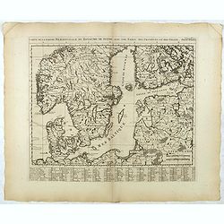
Carte de la Partie Meridionale du Royaume de Suede...
Map of the southern part of Scandinavia with letter key at the bottom.Zacharie Chatelain (d.1723) was the father of Henri Abraham (1684-1743) and Zacharie Junior (1690-17...
Date: Amsterdam, ca. 1732
Selling price: ????
Please login to see price!
Sold in 2017
Carte de la Partie Septentrionale du Royaume de Suede...
Map of the northern part of Scandinavia. It covers the area straddling Norway, Sweden, Finland and Russia.Zacharie Chatelain (d.1723) was the father of Henri Abraham (168...
Date: Amsterdam, ca. 1732
Selling price: ????
Please login to see price!
Sold in 2017
Plan de la Ville, Faubourg et environs de Dantzick, dédié et présenté à la Reine. (Gdansk )
Decorative and rare plan of Gdansk and the castle Weichselmunde by Jean de Beaurain (1696-1771). With a dedication to Marie Leszczynska (Queen of France). At the bottom o...
Date: Paris, 1732
Selling price: ????
Please login to see price!
Sold in 2020
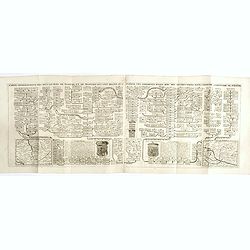
Carte du calendrier ancien rangé en parallèle avec le nouveau et l'usage qu'on en peut faire pour l'intelligence de l'histoire par ou on fait voir la manière de . . .
Chart of the old and new calendars.Henri Abraham Chatelain (1684 – 1743) was a Huguenot pastor of Parisian origins. He lived consecutively in Paris, St. Martins, London...
Date: Amsterdam, 1720-1732
Selling price: ????
Please login to see price!
Sold in 2023
Carte Genealogique des Rois de Portugal & Partie des Differentes Branches qu'ils ont Formee avec le Blazon de leurs Armes & de leurs Alliances.
A genealogical tree of the Portuguese Kings with descriptive, from Chatelain's monumental 7 volume "Atlas Historique". Henri Abraham Chatelain (1684 – 1743) w...
Date: Amsterdam, 1720-1732
Selling price: ????
Please login to see price!
Sold in 2018
Carte genealogique des Ducs et Rois de Boheme et de Hongrie qui ont regné ou gouverné ces differents etats avec des instructions pour conduire à l'histoire de POLOGNE. . .
A genealogical tree of the Bohemian ducks and kings, from Chatelain's monumental 7 volume "Atlas Historique". This two sheet print features two maps (115 x 153m...
Date: Amsterdam, 1719-1732
Selling price: ????
Please login to see price!
Sold in 2017
Carte pour servir à l'intelligence de l'histoire eclessiastique et a faire connoitre les persecutions de l'Eglise . . .
Two sheet engraving explaining the various religious divisions in Europe. In the center a map (210 x 350mm.) of Europe and Turkey. To the lower left a map of Egypt and to...
Date: Amsterdam, 1720-1732
Selling price: ????
Please login to see price!
Sold in 2017
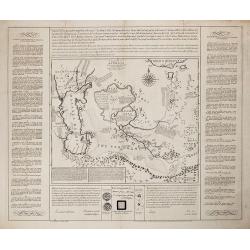
Richtige Marsch Carten der Saltzburgischen Emigraten oder deren Zug aus Saltzburg durch das Reich in die Konigl. Preusisch Lande.
An scarce and interesting historical map by Peter Conrad Monath, covering the 'Great Emigration' that came about on the 31st October 1731, after the (then) Archbishop of ...
Date: Nuremberg, 1732
Selling price: ????
Please login to see price!
Sold
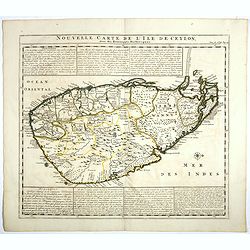
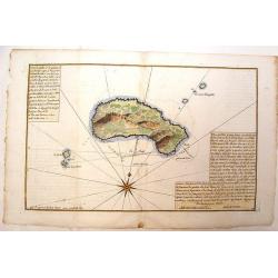
Nouvelle carte de l'Ile de Ceylon, avec des remarques Historiques.
Map of Ceylon.Henri Abraham Chatelain (1684 – 1743) was a Huguenot pastor of Parisian origins. He lived consecutively in Paris, St. Martins, London (c. 1710), the Hague...
Date: Amsterdam, 1719-1732
Selling price: ????
Please login to see price!
Sold in 2017
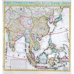
Carte des Indes, de la Chine & des Isles de Sumatra, Java &c.
Fine map of South East Asia.Zacharie Chatelain (d.1723) was the father of Henri Abraham (1684-1743) and Zacharie Junior (1690-1754).They worked as a partnership publishin...
Date: Amsterdam, 1719-1732
Selling price: ????
Please login to see price!
Sold in 2019
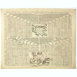
Chronologie des Etats & Empires du Monde depuis Adam jusqu'au au Commencement de l'Ere Vulgaire.
Graving showing the timeline of earth history from Adam to the beginning of the birth of Christ with inlay map of Peloponnese (120x130mm.) and in bottom Europe in the Bro...
Date: Amsterdam, 1720-1732
Selling price: ????
Please login to see price!
Sold in 2017
Carte du calendrier ancien rangé en parallèle avec le nouveau et l'usage qu'on en peut faire pour l'intelligence de l'histoire par ou on fait voir la manière de . . .
Chart of the old and new calendars.Henri Abraham Chatelain (1684 – 1743) was a Huguenot pastor of Parisian origins. He lived consecutively in Paris, St. Martins, London...
Date: Amsterdam, 1720-1732
Selling price: ????
Please login to see price!
Sold in 2018