Browse Listings
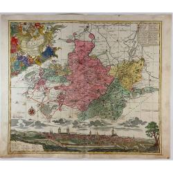
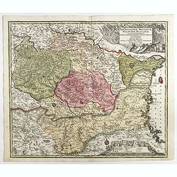
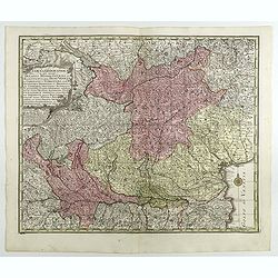
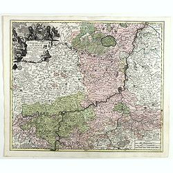
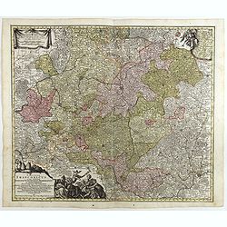
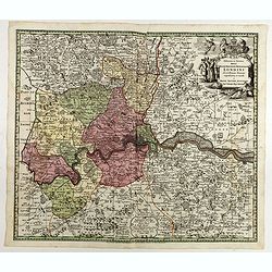
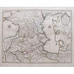
Episcopatus Numburgensis et Cizensis. . .
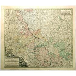
This interesting map of Eastern Germany by Seutter shows the region just to the south of Merseburg, with Naumburg to the west and Zeitz to the south. At the bottom is a l...
Date: Nuremberg, 1730
Selling price: ????
Please login to see price!
Sold in 2021
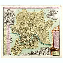
Veteris et Modernaeurbis Romae Ichnograpphia..
A striking city plan of Rome with vibrant original color. The plan is beautifully embellished with allegorical scenes. In the lower right a vignette portraying the tribut...
Date: Augsburg, ca. 1730
Selling price: ????
Please login to see price!
Sold in 2017
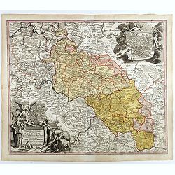
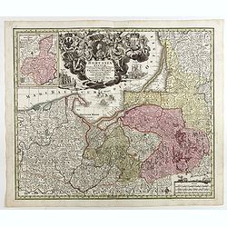
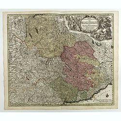
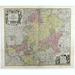
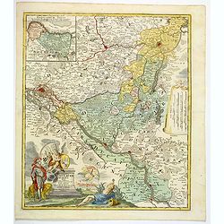
Superioris et inferioris ducatus Silesiae in suos XVII minores principatus et dominia divisi nova tabula. . .
Detailed map of the region dissected by the Oder, showing Wroclaw, Breslau, Silesia, with a large cartouche and large inset plan of Brelaw, held aloft by Cherubs. Shows c...
Date: Nuremberg, ca. 1730
Selling price: ????
Please login to see price!
Sold in 2018
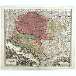
Nova et accurata Hungariae cum adiacentib. regn. et principatibus tabula. . .
Map of the Balkan showing Hungary, Serbia, Croatia, Bosnia and Herzegovina and Albania. With two beautiful cartouches. Shows cities and towns, place names, rivers, forest...
Date: Augsbourg, 1730
Selling price: ????
Please login to see price!
Sold in 2018
Transylvaniae, Moldaviae, Walachiae, Bulgariae, nova et accurata Delineatio, Magnam Partem Hodierni Theatri Bellici . . .
Map shows Southeast Europe with Transylvania, Moldavia, Bulgaria and the Walachia, with engraved detailed hand colored map. Includes decorative cartouche. Shows cities an...
Date: Augsbourg, 1730
Selling price: ????
Please login to see price!
Sold in 2017
Borussiae Regnum sub fortissimo Tutamine et justissimo Regimine Friderici Wilhelmi. . .
Covers Prussia, Pomerania, Planica, Hockerlandia, Pomesania, Warmiaermelandia, Natanglensis, Galindia, Nandrovia, Sclavonia, and the Baltic Sea.In top center a large cart...
Date: Augsbourg, 1730
Selling price: ????
Please login to see price!
Sold in 2017

Marchionatus Brandenburgensis Ducatus Pomeraniae et Ducatus Mecklenburgicus.. . . .
Seutter's well-engraved map has a large decorative cartouche. Including the towns of Wismar, Stettin, Berlin, etc.Matthaus Seutter the elder first published his "Atl...
Date: Augsbourg, 1730
Selling price: ????
Please login to see price!
Sold in 2017
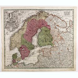
Synopsis Plagae, Septentrionalis sive Sueciae Daniae, et Norwegiae Regn . . .
Decorative map of Scandinavia, the Baltic and contiguous parts of Russia, with an ornate cartouche which features a portrait of Ulrica Eleonora, the Queen of Sweden, rest...
Date: Augsbourg, 1730
Selling price: ????
Please login to see price!
Sold in 2017
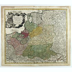
Regni Poloniae Magnique Ducatus Lithuaniae Nova et exacta tabula ad memtem Starovolcy descripta . . .
Map of Poland, Lithuania, Latvia, Estonia and a portion of Russia and the Ukraine, extending from the Oder to the Black Sea and Smolensk, centered on Vilna.
Date: Nuremberg, ca. 1730
Selling price: ????
Please login to see price!
Sold in 2018
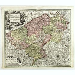
Flandria Maximus Et Pulcherrimus Europae Comitatus in suas Ditiones accurate distinctus. . .
A fine impression of this decorative map with its uncolored title cartouche, showing Flanders including the towns of Gent, Sluis, Bruges, Ostend, Brussels, Lille, Dunkerq...
Date: Augsbourg, 1730
Selling price: ????
Please login to see price!
Sold in 2018
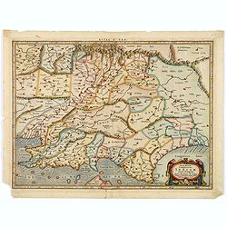
Tab.X Asiae Complectens Indiam intra gangem. . .
A Ptolemaic view of India. The Himalayan Mountains stretch across the top of the map and the Indus and Ganges river systems are well delineated. The subcontinent is consi...
Date: Amsterdam, 1730
Selling price: ????
Please login to see price!
Sold in 2018
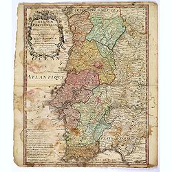
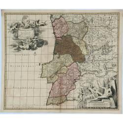
Regnum Portugalliae. . .
A detailed and uncommon map of Portugal and the Algarve, colored by provinces, showing towns, rivers, mountains, harbors, roads, etc. Embellished with a very large title ...
Date: Nuremberg, 1730
Selling price: ????
Please login to see price!
Sold in 2017
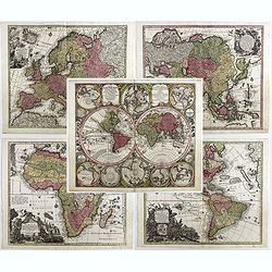
Diversi GLOBI TERR-AQUEI Statione Variante et Visu intercedente,. . .
A matching set of the world in double hemispheres and maps of the four continents.Here in a first edition without the privilege.Diversi GLOBI TERR-AQUEI Statione Variante...
Date: Augsbourg, c.1730
Selling price: ????
Please login to see price!
Sold in 2017
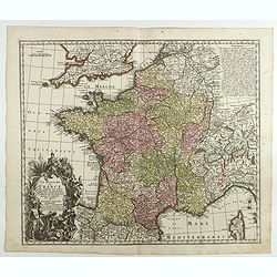
Le Royaume de France . . .
A finely engraved and decorative mid-18th century map published in Augsburg, Germany. This map shows France.Matthaus Seutter the elder first published his "Atlas Geo...
Date: Augsburg, c. 1730
Selling price: ????
Please login to see price!
Sold in 2018
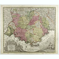
Provincia Gallis la Provence dicta..
Seutter's well-engraved map of southern France has two large decorative cartouche. Including the towns of Marseille, Toulouse, St.Tropez, Cannes, Antibes, etc.Matthaus Se...
Date: Nuremberg 1730
Selling price: ????
Please login to see price!
Sold in 2017
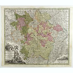
Mappa Geographica in qua Ducatus Lotharingiae...
Map of eastern France with the Alsace area, centered on Metz.Matthaus Seutter the elder first published his "Atlas Geographicus" in 1720 and added to the conten...
Date: Augsburg, 1730
Selling price: ????
Please login to see price!
Sold in 2017
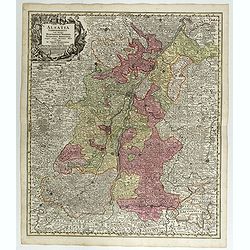
Alsatia Landgraviatus . . .
Map of eastern France centered on Strasburg and Basel in the South.Matthaus Seutter the elder first published his "Atlas Geographicus" in 1720 and added to the ...
Date: Augsburg, 1730
Selling price: ????
Please login to see price!
Sold in 2017
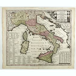
Italiae antique item insularum Siciliae, Sardiniae, Corsica . . .
Map of ancient Italy.Matthaus Seutter the elder first published his "Atlas Geographicus" in 1720 and added to the contents in subsequent editions under the titl...
Date: Augsburg, 1730
Selling price: ????
Please login to see price!
Sold in 2018
Regiae Celsitudinis Sabaudicae Status in quo Ducatus Sabaudiae Principat Pedemontium. . .
A nice example of Seutter's decorative map of the Savoy and Piedmont regions, in northern Italy, centered on Torino. The map coverage extends from Grenoble, Geneva, Die a...
Date: Augsburg, 1730
Selling price: ????
Please login to see price!
Sold in 2018
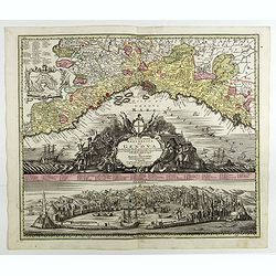
Lo Stato della Republica di Genova.
Decorative and detailed map of Republic of Genoa with a fine view of the harbor and city below. A numbered key identifies 64 buildings and locations. Matthaus Seutter the...
Date: Augsburg, 1730
Selling price: ????
Please login to see price!
Sold in 2018
Ducatus Mediolanensis cum adjacentibus Principat. Et Dominiis. . .
Detailed map showing Lombardi with Lago Maggiore, Lake Lugano, Lake Como, Iseo-, Idro- and Lake Garda between Chiavenna, Trient, Modena, Genua, Asti and Brig.Matthaus Seu...
Date: Augsburg, 1730
Selling price: ????
Please login to see price!
Sold in 2018
Tabula Geographica in qua integri Ducatus Mediolanensis. . .
Map of Milan region, extending to Venice.Matthaus Seutter the elder first published his "Atlas Geographicus" in 1720 and added to the contents in subsequent edi...
Date: Augsburg, 1730
Selling price: ????
Please login to see price!
Sold in 2018
Ducatus Parmensis Et Placentinus. Ducatus Parmensis Et Placentinus. . .
Map of Parma region.Matthaus Seutter the elder first published his "Atlas Geographicus" in 1720 and added to the contents in subsequent editions under the title...
Date: Augsburg, 1730
Selling price: ????
Please login to see price!
Sold in 2018
Novissima et accuratior tabella magni ducatus Hetruriae complectens hodie tria territor. Florentinum, Pisanum et Senense cum insula Elba et locis quibusdam . . .
Scarce map of the region around Tuscany, Florence, Pisa, Siena end Elba Island, with a gorgeous cartouche.Matthaus Seutter the elder first published his "Atlas Geogr...
Date: Augsburg, 1730
Selling price: ????
Please login to see price!
Sold in 2017
Dominium Venetum . . .
Seutter's well-engraved map showing Venice, Verona, Cremona, Bergamo, etc. has a large decorative cartouche. Some boats offshore Venice. The map is in original wash color...
Date: Augsburg, 1730
Selling price: ????
Please login to see price!
Sold in 2018
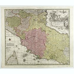
Novissima et accuratissima Delineatio Status Ecclesiae, et Magni Ducatus Hetruriae . . .
Striking map of Central Italy, from Mantua, Cremona, Piacenza and Ferrara in the north to Roma in the South and including Ancon on the Adriatic. Centered on Florence and ...
Date: Augsburg, 1730
Selling price: ????
Please login to see price!
Sold in 2017
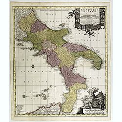
Neapolis Regnum . . .
Map of the region from Naples to Calabria. Cartouche representing Vesuvius erupting.Matthaus Seutter the elder first published his "Atlas Geographicus" in 1720 ...
Date: Ausburg, 1730
Selling price: ????
Please login to see price!
Sold in 2017
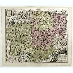
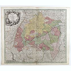
RHAETIA Foederata cum Confinibus et Subditis suis VALLE TELINA, COMITATU CLAVENNENSI ET BORMIENSI...delineata ˆ Gabriele Walzero..
Engraved by Andreas Silbereisen. This decorative map shows Graubünden. Very good impression done on thick paper.Matthaus Seutter the elder first published his "Atla...
Date: Ausburg, 1730
Selling price: ????
Please login to see price!
Sold in 2018
Imperium Romano Germanicum . . .
Map of central Europe centered on Germany, but including Poland, the Low Countries, Switzerland, Austria, etc. No text on verso. Very good impression done on thick paper....
Date: Ausburg, 1730
Selling price: ????
Please login to see price!
Sold in 2017
Postarum seu cursorum publicorum diverticula et mansiones per Germaniam et confin. Provincias, opera et manu M. Seutteri. . .
Post route map of Germany, including Poland, the Low Countries, Switzerland and Austria. No text on verso. Very good impression done on thick paper.Matthaus Seutter the e...
Date: Ausburg, 1730
Selling price: ????
Please login to see price!
Sold in 2017
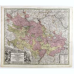
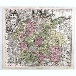
Palatinatus inferior, sive Electoratus Palatinus ad Rhenum . . .
Detailed map of the lower Rhine circles showing the area from east of Heidelberg towards Saarlouis. No text on verso. Very good impression done on thick paper.Matthaus Se...
Date: Ausburg, 1730
Selling price: ????
Please login to see price!
Sold in 2018
Trevirensis Archi-Episcopatus et Electoratus . . .
Map of the south-west part of Germany with one decorative figure cartouche. Including the river Rhine, Bonn, Trier, etc. No text on verso. Very good impression on thick p...
Date: Ausburg, 1730
Selling price: ????
Please login to see price!
Sold in 2018
Mappa geographica continens archiepiscopatum et electoratum Coloniensem . . .
Detailed map centered on Cologne. No text on verso. Very good impression done on thick paper.Matthaus Seutter the elder first published his "Atlas Geographicus"...
Date: Ausburg, 1730
Selling price: ????
Please login to see price!
Sold in 2017
L'Eveche et l'Etat de Liege . . .
Detailed map centered on Liege. No text on verso. Very good impression done on thick paper.Matthaus Seutter the elder first published his "Atlas Geographicus" i...
Date: Ausburg, 1730
Selling price: ????
Please login to see price!
Sold in 2018
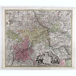
Circulus Suevicus in quo Ducatus Wirtenbergensis...
Map of Swabia including Strasburg, Manheim, Lucern, Boden See, Stuttgart.Matthaus Seutter the elder first published his "Atlas Geographicus" in 1720 and added t...
Date: Augsbourg, 1730
Selling price: ????
Please login to see price!
Sold in 2017
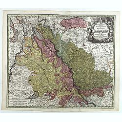
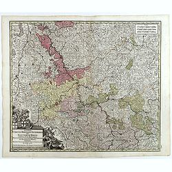
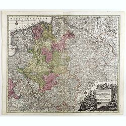
Mappa circuli Rhenani superioris . . .
Detailed map of Eastern Germany. Engraved detailed hand colored outline map. Includes decorative cartouche, compass rose and coat of arms. Shows cities and towns, place n...
Date: Augsbourg, 1730
Selling price: ????
Please login to see price!
Sold in 2018
Circuli Rhenani Inferioris sive Electorum Rheni . . .
Engraved detailed map of the Rhine river with Dusseldorf, Bonn, Coblenz, Mainz. Includes decorative cartouche, compass rose and coat of arms. Shows cities and towns, plac...
Date: Augsbourg, 1730
Selling price: ????
Please login to see price!
Sold in 2018
Circulus Franconicus . . .
A fine map of the Franconia region of Germany, centered on Bamberg and Schweinfurth. Includes decorative uncolored cartouche, compass rose and coat of arms. Shows cities ...
Date: Augsbourg, 1730
Selling price: ????
Please login to see price!
Sold in 2018
Circulus Westphalicus in suas Provincias et Ditiones accurate distinctus et recentissime delineat / cura et caelo . . .
Engraved detailed hand colored map of Northern Germany. Includes decorative cartouche. Shows cities and towns, place names, rivers, forests and mountains.Matthaus Seutter...
Date: Augsbourg, 1730
Selling price: ????
Please login to see price!
Sold in 2017
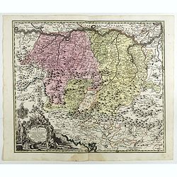
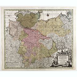
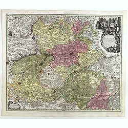
Saxoniae Superioris Circulus . . .
Map of Lower Saxony, extending from the Baltic to Berlin, Hall... With engraved detailed hand colored outline map. Includes decorative cartouche. Shows cities and towns, ...
Date: Augsbourg, 1730
Selling price: ????
Please login to see price!
Sold in 2018
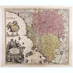
Saxoniae Inferioris Circulus . . .
Map of lower Saxony, including Berlin, Hamburg, the Baltic region. With engraved detailed hand colored outline map. Includes decorative cartouche. Shows cities and towns,...
Date: Augsbourg, 1730
Selling price: ????
Please login to see price!
Sold in 2018
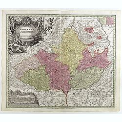
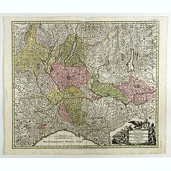
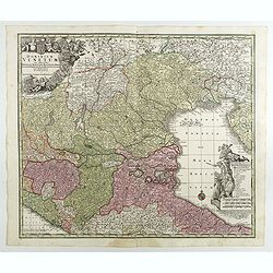
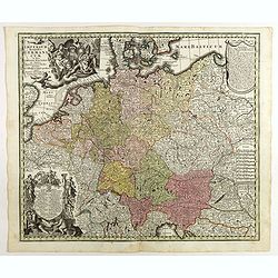
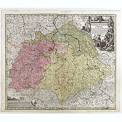
Moravia marchionatus in sex circulos divisus . . .
Map of the county of Moravia, boarded by Bohemia, Silesia, Hungary and Austria, with engraved detailed hand colored map. Includes decorative cartouche. Shows cities and t...
Date: Augsbourg, 1730
Selling price: ????
Please login to see price!
Sold in 2018
Comitatus Hanoviae . . .
A fine impression of this decorative map centered on Mons and Valenciennes with its uncolored title cartouche.Matthaus Seutter the elder first published his "Atlas G...
Date: Augsbourg, 1730
Selling price: ????
Please login to see price!
Sold in 2018
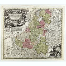
XVII Provinciae Belgii five Germaniae inferioris. . .
Decorative map of the Low Countries including Belgium, Luxemburg, the Netherlands, title surrounded by mythological figures and 17 coats of arms and 1 other cartouche low...
Date: Augsburg, 1730
Selling price: ????
Please login to see price!
Sold in 2018
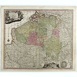
Germaniae Inferioris Sive Belgii Pars Meridionalis exhibens X. Provincias Catholi. Cum Confiniis Galliae Germ. Hollandiae recentissime et curatissime in lucem edita . . .
Decorative regional map of Belgium, centered on Namur. Inset plan of Oostende. Includes decorative cartouche. Shows cities and towns, place names, rivers and forests.Matt...
Date: Augsburg, 1730
Selling price: ????
Please login to see price!
Sold in 2018
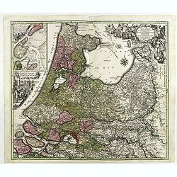
Tabula Comitatus Hollandiae in Praefecturas sua distributa, cui adjuncta est Provinc. Ultraiectina et maxima pars Geldriae summo studio delin. . .
Fine map of the provinces of North and South Holland. In upper left hand corner an inset with the islands of Texel and Vlieland. Just below the inset map a harbour scene ...
Date: Augsburg 1730
Selling price: ????
Please login to see price!
Sold in 2018
Delineatio ac finitima Regio Londini.
Centered on London, including towns of Hatfield, Tilbury, Walton on the Hill and Chertsey. Title in cartouche with royal arms, figure of Mercury, group of merchants. Boun...
Date: Ausburg, 1730
Selling price: ????
Please login to see price!
Sold in 2022
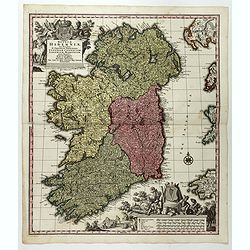
Regnum Hiberniae, tam Secundum IV Provincias Principales Ultoniam, Connaciam, Lageniam, et Momoniam quam peciales, accurate. . .
A very decorative and detailed map of Ireland based on Visscher's map. In upper left corner a large title cartouche with the royal British arms and lower right a large pi...
Date: Augsburg, 1730
Selling price: ????
Please login to see price!
Sold in 2017
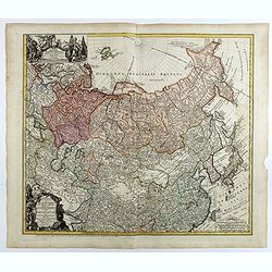
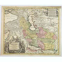
Imperii Russici et Tatariae Universae tam majoris et Asiaticae quam minoris et Europae Tabula.
Detailed map of the Asian part of the Russian Empire, from the Caspian Sea and Bergen Island to Japan and the Pacific.
Date: Augsburg, 1730
Selling price: ????
Please login to see price!
Sold in 2018
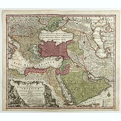
Magni Turcarum Dominatoris Imperium per Europam ..
Alluring map of the Near and Middle East centered on Turkey, giving good detail in the Arabian Peninsula.With large cartouche in lower left depicting figures with turbans...
Date: Augsburg, 1730
Selling price: ????
Please login to see price!
Sold in 2018
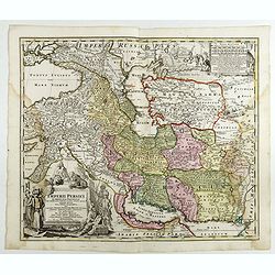
Imperii Persici in omnes suas Provincias . . . Exacte Divisi Nova Tabula Geographica. . .
Showing the eastern part of Turkey and Cyprus, Palestine, Persian Gulf, including Gulf of Oman, Caspian Sea, Iran and the north-west territories of India.Embellished with...
Date: Ausburg, 1730
Selling price: ????
Please login to see price!
Sold in 2017
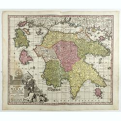
Peloponnesus Hodie Morea Ad Normam Veterum Et Recentiorum Mappa Accuratissime Adornata Aeri Incisa Et Venalis. . .
Decorative regional map of Morea and contiguous islands, with an ornate cartouche showing a lion bearing a sword defeating Turkish and other invaders.Matthaus Seutter the...
Date: Augsburg, 1730
Selling price: ????
Please login to see price!
Sold in 2018
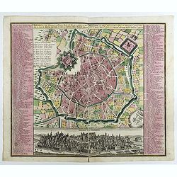
Milano, la Citta Principale et Fortezza Reale del Ducato medsino in Italia . . .
Fine example of Seutter's decorative and highly detailed plan of Milan, with a striking panoramic view of the City below. Matthaus Seutter the elder first published his &...
Date: Augsburg, 1730
Selling price: ????
Please login to see price!
Sold in 2017
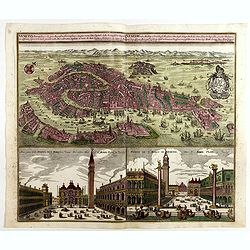
Venetia potentissima e la più magnifica fiorentissimae la più ricca città capitale della Serenissima repubblica . . .
Birds-eye plan view of Venice, depicting the city's architectural landmarks. Below Saint Marco square.Matthaus Seutter the elder first published his "Atlas Geographi...
Date: Augsburg, 1730
Selling price: ????
Please login to see price!
Sold in 2018
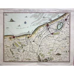
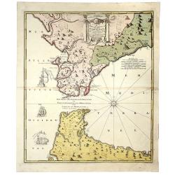
Carte Particulière des Environs de Dunkerque, Bergues, Furnes, Gravelines, Calais et autres.
A fine example of Covens & Mortier's regional map of the Belgian - French coastline showing; Dunkerque, Bergtues, Furnes, Gravelines, Calais and other cities. This at...
Date: Amsterdam, 1730
Selling price: ????
Please login to see price!
Sold in 2019
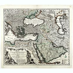
Magni Turcarum Dominatoris Imperium per Europam . . .
Alluring map of the Near and Middle East centered on Turkey, giving good detail in the Arabian Peninsula.With large cartouche in lower left depicting figures with turbans...
Date: Augsburg, 1730
Selling price: ????
Please login to see price!
Sold in 2019
Nova Regni Portugallia et Algarbiae Descriptio.
A scarce map of Portugal with the various regions, towns, cities, rivers, and mountains depicted. The map features two large cartouches. The title cartouche has a drape h...
Date: Amsterdam, ca 1730
Selling price: ????
Please login to see price!
Sold in 2018
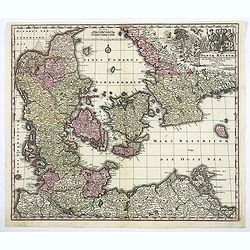
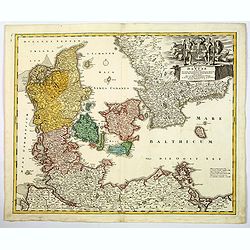
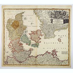
Daniae Regnum cum Ducatu Holsatiae et Slevici. . .
A decorative and detailed map of Denmark, enhanced by a lovely title cartouche in the top right corner, contains the Danish coat of arms, animals, cherubs and the bounty ...
Date: Nuremberg, 1730
Selling price: ????
Please login to see price!
Sold in 2020
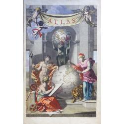
ATLAS PARS II.
Reiner & Josua Ottens, Atlas Pars II, engraved hand colored title page circa 1730, by J van Munnikhuysen after L Webbers,
Date: Amsterdam, 1730
Selling price: ????
Please login to see price!
Sold in 2020
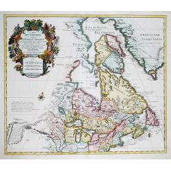
Carte du Canada ou de la Nouvelle France. . .
First issued by Guillaume Delisle in 1703, this important, detailed map provides the most accurate rendering of the Great Lakes of the time, with the lakes fully enclosed...
Date: Amsterdam, c.1730
Selling price: ????
Please login to see price!
Sold in 2019
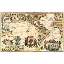
Carte Nouvelle de la Mer du Sud.
Large and spectacular map on 2 joined sheets, title, most cartouches and place names in French, one cartouche in Latin and one in Dutch. The engraved vignettes include: a...
Date: Amsterdam, 1730
Selling price: ????
Please login to see price!
Sold in 2018
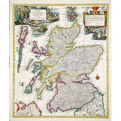
Nova et accurata Scotiae, secundum omnes Provincias.
A decorative and detailed map of Scotland. Embellished with two large cartouches. Matthaeus Seutter (1678-1757), was a cartographer of Vienna and Augsburg. 'Atlas Geogr'...
Date: Augsburg, ca 1730
Selling price: ????
Please login to see price!
Sold in 2020
Imperii Persici in omnes suas Provincias . . . Exacte Divisi Nova Tabula Geographica. . .
A fine and handsome map showing the eastern part of Turkey and Cyprus,
Date: Ausburg, 1730
Selling price: ????
Please login to see price!
Sold in 2019
Veuë de la Ville de Geneve du coté du Midy.
A very large (77,5cm wide) 18th century copper engraving with a view of the Swiss city of Geneva from the south, with Lake Geneva behind the city. Engraved by A. Chopy on...
Date: Paris, 1730
Selling price: ????
Please login to see price!
Sold in 2018
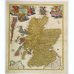
Magnae Britanniae Pars Septentrionalis qua REGNUM SCOTIAE. . .
A large, detailed and decorative map of Scotland with two superb cartouches. They are surrounded by mythical and allegorical figures, five putti, and the Royal & Scot...
Date: Nuremberg, 1730
Selling price: ????
Please login to see price!
Sold in 2019
![Collegium Reginense - Queen's College. [Oxford]](/uploads/cache/43162-250x250.jpg)
Collegium Reginense - Queen's College. [Oxford]
A lovely double page, folio copper engraved print of Queen's College, Oxford by William Williams (fl.1724-1733). Originally published in:- Oxonia Depicta sive Collegiorum...
Date: Oxford, ca 1730
Selling price: ????
Please login to see price!
Sold in 2020
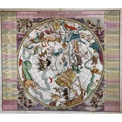
Hemisphaerium Coeli Australe in quo loca Stellarum fixarum secundum Aequatoreum, per Ascensiones nempe rectas et Declinationes ad anum Christi 1730.
Folio-size copper engraving of the southern hemisphere. A very decorative map. The signs of the zodiac are presented in the middle. The corners of the chart are decorated...
Date: Nuremberg, 1730
Selling price: ????
Please login to see price!
Sold in 2020
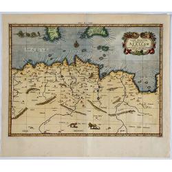
Tab. II Africae, complectens Africam. . .
From the last edition of Mercator’s Ptolemaeic Atlas by Georgius Hornius, with the Mediterranean labeled ‘Aphricum Pelagus’, the land mass with mountain ridges and ...
Date: Amsterdam, 1578, but 1730
Selling price: ????
Please login to see price!
Sold in 2019
Synopsis Circuli Rhenani Inferioris Sive Electorum Rheni...
A striking map of the lower Rhine by Seutter. Features a decorative title cartouche. One of the great 18th century German cartographic families was the Seutters. George ...
Date: Augsburg, 1730
Selling price: ????
Please login to see price!
Sold in 2021
Regni Daniae in que sunt. . .
A nice colored map of Denmark, Schleswig-Holstein and Mecklenburg in Germany, extending from Hamburg in the south to southern Sweden in the north. Embellished with an att...
Date: Nurnberg, ca 1730
Selling price: ????
Please login to see price!
Sold in 2021
![Mappa geographiae naturalis sive Tabella Synoptica...[guide to the mapmaker's art]](/uploads/cache/82682-250x250.jpg)
Mappa geographiae naturalis sive Tabella Synoptica...[guide to the mapmaker's art]
This is a rare cartographic curiosity designed to illustrate the map drawing process. It consists of an imaginary map with a variety of cultural, geographical, and physic...
Date: Augsburg, 1730
Selling price: ????
Please login to see price!
Sold in 2019
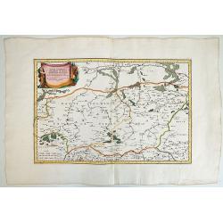
HAUTE VOLHYNIE ou PALATINAT DE LUSUC,titre de la grande carte de l Ukraine du S.le Vasseur de Beauplan.
Fine map of Volinia, a region actually in North West Ukraine, at that time territory of Poland Federation.The map has been prepared by Robert ( de Vaugondy ) in Paris and...
Date: Paris, 1730
Selling price: ????
Please login to see price!
Sold in 2019
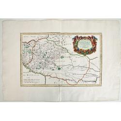
BASSE PODOLIE ou PALATINAT DE BRACLAW ,tiré de la Grande Ukraine de S. le Vasseur de Beauplan.
Fine map of Podolia ,a region actually in North West Ukraine ,but that time territory of Poland Confederation. This map by Robert ( de Vaugondy ) has been based in the pr...
Date: Paris, 1730
Selling price: ????
Please login to see price!
Sold in 2019
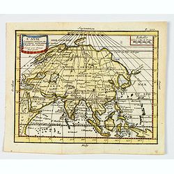
L'Asie. . .
A nice, small map of the continent of Asia, stretching from Scandinavia, Turkey in Asia, Arabia and eastern Africa across to China and Japan, and south to Borneo and Papu...
Date: Paris, ca 1730
Selling price: ????
Please login to see price!
Sold in 2019
Regni Daniae in quo sunt. . .
A beautifully detailed c. 1730 J. B. Homann map of Denmark, that depicts both the Danish peninsular together with some parts of northern Germany and southern Sweden. The ...
Date: Nuremberg, 1730
Selling price: ????
Please login to see price!
Sold in 2021
Carte des Pays Voisins de la Mer Caspiene. . .
An excellent map of the Caspian Sea, todays Georgia, Armenia and Azerbaijan. Includes also a part of the Black Sea, Turkmenistan, Iran, Russia, and Turkey. Highly detaile...
Date: Amsterdam, ca 1730
Selling price: ????
Please login to see price!
Sold in 2019
Typus Geographieus Ducat. Lauen Burgici. . .
Johann Baptist Homann's detailed and well-engraved northern German provincial map has a striking, large and decorative title cartouche in the lower left corner. The map i...
Date: Nuremberg, 1730
Selling price: ????
Please login to see price!
Sold in 2019
Carte nouvelle de L'ISLE de CADIX & du Detroit de GIBRALTAR.
A decorative map centered on the Strait of Gibraltar. With an inset plan of Gibraltar, decorative title cartouche and four vessels.
Date: Nuremberg, 1730
Selling price: ????
Please login to see price!
Sold in 2019
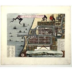
Plan de la Ville et du Chateau de BATAVIA en l'Isle de Iava (JAKARTA).
A detailed east oriented Dutch plan of Jakarta (former Batavia) in Java / Indonesia. With a bird eye view from the sea side, with various ships and a lion. Two inset keys...
Date: Leiden, 1730
Selling price: ????
Please login to see price!
Sold in 2019
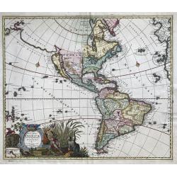
Recentissima Novi Orbis, Sive Americae Septentrionalis et Meridionalis Tabula.
Attractive map of the Americas features a beautiful rich decorative title cartouche showing an Amazonian queen surrounded by riches, a sugar cane field and exotic animals...
Date: Amsterdam, ca 1730
Selling price: ????
Please login to see price!
Sold in 2020