Browse Listings
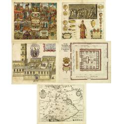
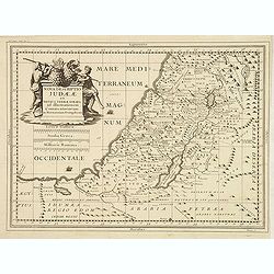
Pantheon sive Idola Judeorum. (together with) Atria Templi Solomonis (together with 4 other maps)
Together five decorative copper engraved plates or map taken from Thomas Fuller, "A Pisgah sight of Palestine" and etched by Vaughan.1./ Pantheon sive Idola Jud...
Date: London, 1650
Selling price: ????
Please login to see price!
Sold in 2012
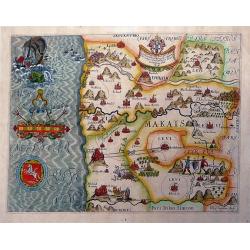
DAN Holy Land by Thomas Fuller.
An scarce and altogether fascinating 1650 map of The tribes of Israel by Thomas Fuller. The map is centered on Bethlehem with Ekron to the west and Lydda to the north, Co...
Date: John Williams, London 1650
Selling price: ????
Please login to see price!
Sold in 2012
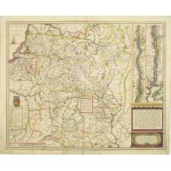
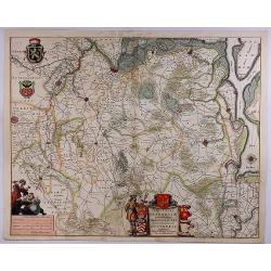
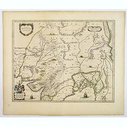
Magni Ducatus Lithuaniae Caetrarumq Regionum illi Adiacentium exacta decrip. . .
Detailed map of Lithuania, Poland and part of Russia up to the River Dnepr, based upon Blaeu's four sheet map. Highly detailed, extending from Cracow to the Baltic in the...
Date: Amsterdam, 1650
Selling price: ????
Please login to see price!
Sold in 2018
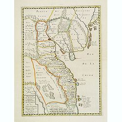
Royaume d'Annan, comprenant les royaumes de Tumkin et de la Cocinchine / désigné par les peres de la Compagnie de Jesus. . .
Showing the Indo China with Vietnam and small portion of southeastern China with coastline till Macao. Engraved by Somer. RARE.
Date: Paris, 1650
Selling price: ????
Please login to see price!
Sold in 2012
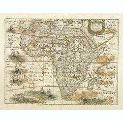
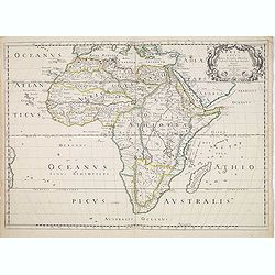
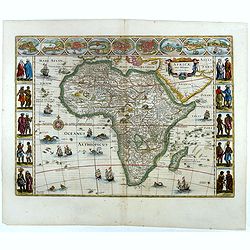
AFRICAE nova Tabula. Auct. Hen. Hondio.
Important map of Africa, it's the issue of Jodocus Hondius map, without the decorative borders. There are six ships in full sail on the Atlantic and one to the south of M...
Date: Amsterdam , 1631-1650
Selling price: ????
Please login to see price!
Sold in 2012
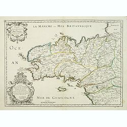
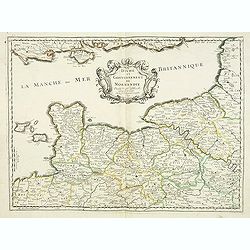
Duche et Gouvernement de Bretagne.
First state of this decorative map of Bretagne, including the cities of Nantes, Rennes, Belle-Île, etc. engraved by Robert Cordier d'Abbauil. The map is dated 1650. In t...
Date: Paris, ca.1650
Selling price: ????
Please login to see price!
Sold
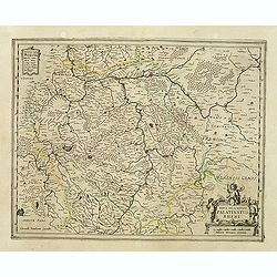
Nova descriptio Palatinatus Rheni.
Detailed map of Germany centered of Manheim. An extremely rare map finely engraved. The map is copied by Cornelis Danckerts II after a map by Henricus Hondius. This map a...
Date: Amsterdam, ca. 1650
Selling price: ????
Please login to see price!
Sold in 2023
Bohemia (Map showing Rübezahl, Giants + Dragon)
Shows the Riesengebirge (Montes Gigantium - mountains of giants), and showing "Ribenzal" (Rübezahl) as figures and a dragon(?). Rare old copper engraving of B...
Date: ?, c1650
Selling price: ????
Please login to see price!
Sold in 2012
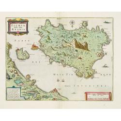
Ischia, quae olim Aenaria.
Prepared by Giulio Iasolino (1537-1622), who wrote a book about Ischia in 1568 and its beneficial baths which included a map of the island, which Ortelius and later Janss...
Date: Amsterdam, 1650
Selling price: ????
Please login to see price!
Sold in 2013
Duche et gouvernement de Normandie.
Fine map of Normandy, with the islands of Jersey and Guernsey. Engraved by R. Cordier d'Abbauil. This edition carries the date 1650. Nicolas Sanson was to bring about the...
Date: Paris, 1650
Selling price: ????
Please login to see price!
Sold
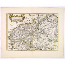
.Catalogne et Arragon.
Early imprint of this fine map of Catalonia. With decorative cartouches for the title and scale. Included in " Theatre geographique de France contenant les cartes pa...
Date: Paris, 1650
Selling price: ????
Please login to see price!
Sold in 2016
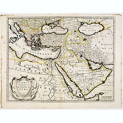
.Carte generalle de L'Empire Turc.
Rare map of the Turkish Empire by Pierre Mariette the elder. With decorative title cartouche. Included in "Cartes Generales de Toutes les Parties du Monde". The...
Date: Paris, 1650
Selling price: ????
Please login to see price!
Sold in 2016
Nova descriptio Judae ae et totius terrae Israel as illustrrationem. . .
Unrecorded map of the Holy Land engraved by Nicolas Berey II.
Date: Paris, ca. 1650
Selling price: ????
Please login to see price!
Sold
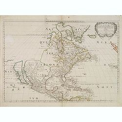
Amerique Septentrionale par N. Sanson.
Decorative and important map of the Americas with a CALIFORNIA AS AN ISLAND. Engraved by Abraham Peyrounim (c.1620 - c.1666).Sanson's map of North America is the first to...
Date: Paris, after 1650
Selling price: ????
Please login to see price!
Sold in 2014
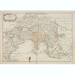
Asie.
Landmark map of Asia, It is the first French map to depict significantly new information. The map is known in one state. The map was prepared and issued separately in 165...
Date: Paris, 1650
Selling price: ????
Please login to see price!
Sold
Confinia Palestinea cum incolis ad Orientem (together with 2 other maps)
Together three decorative copper engraved maps taken from Thomas Fuller, "A Pisgah sight of Palestine" and etched by Vaughan. Engraved by John Golddard. and Tho...
Date: London, 1650
Selling price: ????
Please login to see price!
Sold in 2013
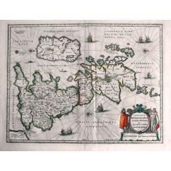
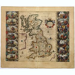
Insularum Britannicarum Acurata Delineatio ex Geographicis Conatibus Abraham Ortelii.
This is Jansson's historical map of the British Isles giving credit to Abraham Ortelius in the title. Engraved by Peter van den Keere. North is oriented to the right. H...
Date: Amsterdam, c1650
Selling price: ????
Please login to see price!
Sold in 2013
Palatina tus ad Rhenum.
A lovely, super-decorated, detailed map of Germany with "three" cartouches depicting "seven" putti plus a coat of arms. The cities, including Bingen, ...
Date: Amsterdam, 1650
Selling price: ????
Please login to see price!
Sold in 2016
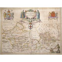
Bercheria vernacule. . . (Barkshire)
‘Bercheria vernacule’ - Barkshire by Joannes Blaeu. A very decorative map, with armorials and escutcheons.
Date: Amsterdam, 1650
Selling price: ????
Please login to see price!
Sold in 2013
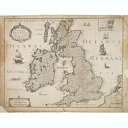
Novissima descriptio Angliae Scotiae et Hiberniae.
Uncommon map of Great Britain and Ireland.
Date: Paris, c. 1650
Selling price: ????
Please login to see price!
Sold in 2015
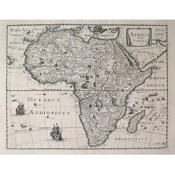
Africa Vetus.
A fine map of the ancient African continent.This edition carries the date 1650, with a privilege of twenty years.Below right Madagascar and left a tip of the South Americ...
Date: Paris, ca. 1650
Selling price: ????
Please login to see price!
Sold
AFRICÆ Noua TABVLA.
A very rare, decorative French map of Africa . Only known example. Apart from its rarity, this is a highly decorative, finely engraved map with several ships in south Atl...
Date: Paris, c.1650
Selling price: ????
Please login to see price!
Sold in 2013
Tartaria Sive Magnichami Imperium.
Decorative copperplate map of china, tartary and Central Asia from Mongolia and Xanadu to the Caspian Sea and Volva River and to Tibet nad the Ganges River. Two splendid ...
Date: Amsterdam, 1650
Selling price: ????
Please login to see price!
Sold in 2016
Mar Del Zur Hispanis Mare Pacificum.
Jansson's fine map of the Pacific including the west coast of America, Japan and a small Australian coastline. This is one of the earliest maps of the Pacific. The first ...
Date: Amsterdam, c.1650
Selling price: ????
Please login to see price!
Sold in 2015
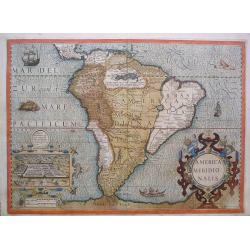
America Meridionalis.
Gerard Mercator's stunning map of South America with Latin text on the verso. The Strait of Magellan is show but Tierra Del Fuego is part of the large southern continent....
Date: Amsterdam, c 1650
Selling price: ????
Please login to see price!
Sold in 2013
Asia noviter delineata..
From 1633 the members of the Blaeu family were official cartographers to the United East India Company and, as such, had access to the most up-to-date cartographic inform...
Date: Amsterdam, 1650
Selling price: ????
Please login to see price!
Sold in 2013
Afrique Par N. Sanson d'Abbevile.
According to Betz, this is a landmark map of Africa, It is the first French map to depict significantly new information. The map is known in one state. The map was prepar...
Date: Paris, 1650
Selling price: ????
Please login to see price!
Sold in 2013
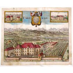
Ehrenau.
Striking detailed, copper engraving of a view of Schloss Ehrenau, Austria. There is a wonderful cartouche featuring two cherubs, a crown and a coat of arms. In addition t...
Date: Germany, 1650
Selling price: ????
Please login to see price!
Sold in 2016
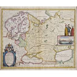
Tabula Russiae.
Map shows total Russia with Scandinavia.
Date: Frankfurt on Main, 1650
Selling price: ????
Please login to see price!
Sold in 2014
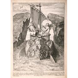
Symplegades.
The Argo passing between the cliffs called Symplegades Mythological subjects, engraved by Cornelis Bloemaert, after Pierre Brebiette and published by Pierre Mariette and ...
Date: Paris, 1650
Selling price: ????
Please login to see price!
Sold in 2014

Prométhée.
Mythological scene with Prometheus lying on a rock, his legs and arms tied down while an eagle picks his liver, by Cornelis Bloemaert, after Jean Varin Published by Pierr...
Date: Paris, 1650
Selling price: ????
Please login to see price!
Sold in 2014
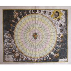
Tabula ANEMOGRAPHICA seu Pyxis Nautica Ventorum nomina sex linguis representans.
Impressive compass rose with a fleur de lis at the center and 32 wind directions flowing from it identified in six languages, Greek, Latin, French, Dutch, Italian, and Sp...
Date: Amsterdam, 1650
Selling price: ????
Please login to see price!
Sold in 2014

Herfordiensis Ecclesiae Cathedralis Ab Aquilone Prospectus.
Striking copper engraving of Herford Cathedral by Wenceslaus Hollar. It was created in about 1650 for Sir. W. Dugdale of England for his well known book featuring British...
Date: London, c1650
Selling price: ????
Please login to see price!
Sold in 2015
Imperium Caroli Magni.
Nice large map showing the Empire of Karol the Great.
Date: Amsterdam, 1650
Selling price: ????
Please login to see price!
Sold in 2017
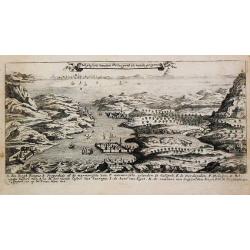
Het ghesicht vanden Hellespont en vande propontide.
From 'Diverse viste delle cita in Candia, Malta, come nel Archipelago'. Etchings by Joh. Peeters, Gaspar Bouttats, Lucas Vorstermans and Coenraad Lauwers. A fine bird's e...
Date: Antwerp, I. Peeters, c. 1650
Selling price: ????
Please login to see price!
Sold in 2014
![[Title page from] Novus Atlas sive Theatrum Orbis Terrarum.](/uploads/cache/93792-250x250.jpg)
[Title page from] Novus Atlas sive Theatrum Orbis Terrarum.
Large-size 17th c Dutch Atlas title page in original color. Geographers Ptolemy and Marinus are depicted along with terrestrial and celestial globes, atlases and surveyin...
Date: Amsterdam, c.1650
Selling price: ????
Please login to see price!
Sold in 2014
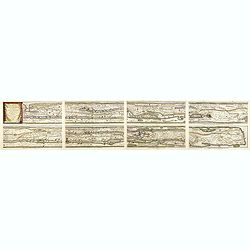
Tabula Itineraria ex illustri Peutingerorum Bibliotheca Quae Auguste Vindelicorum.
Eight segments on four sheets making up the famous Peutinger Table, or a Roman road map of the world. The map depicts the imperial roads and posts within the Roman Empire...
Date: Amsterdam, ca. 1650
Selling price: ????
Please login to see price!
Sold in 2015
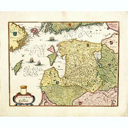
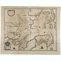
Livonia vulgo Lyefland.
Showing the Baltic region with present-day Estonia, Latvia and Lithuania, with the Baltic Sea, as well as the neighboring coastlines of Sweden and Finland. Based on a map...
Date: Frankfurt, 1650
Selling price: ????
Please login to see price!
Sold in 2018
Magni Ducatus Lithuaniae Caetrarumq Regionum illi Adiacentium exacta decrip. . .
Detailed map of Lithuania, Poland, and part of Russia up to the River Dnepr, based upon Blaeu's four-sheet map. Highly detailed, extending from Cracow to the Baltic in th...
Date: Amsterdam, 1650
Selling price: ????
Please login to see price!
Sold in 2017
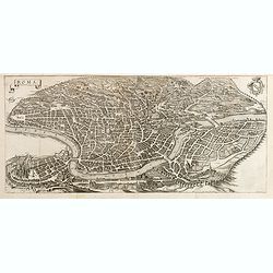
Roma.
Large and detailed bird's-eye town-view of Rome, published and engraved by Matthaeus Merian around 1641. With city arms to the top right corner. One of the most beautiful...
Date: Frankfurt, 1650
Selling price: ????
Please login to see price!
Sold in 2017
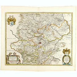
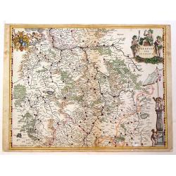
Thuringia landgraviatus...
Detailed map of Thuringa centered on Erfurd on the middle of the map. Showing also Weimar. Embellished with a very decorative title cartouche surrounded by six cherubs. I...
Date: Amsterdam, 1650
Selling price: ????
Please login to see price!
Sold in 2016
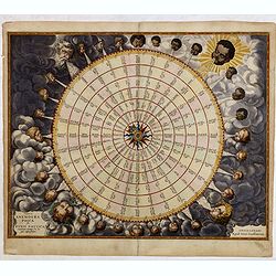
Tabula Anemographica seu Pyxis Nautica.
Impressive compass rose with a fleur de lis at the center and 32 wind directions flowing from it identified in six languages, Greek, Latin, French, Dutch, Italian, and Sp...
Date: Amsterdam, 1650
Selling price: ????
Please login to see price!
Sold in 2015

Afbeeldinge in Wat Manier de Silver Vloot Vanden Generael Pieter Pietersen Heyn Veroovert is Anno 1628.
Decorative view showing the Dutch capture of the Spanish silver fleet in the Bay of Matanzas (Cuba) in 1628. With the portrait of Admiral Hein, who captured over eleven m...
Date: Amsterdam, c1650
Selling price: ????
Please login to see price!
Sold in 2015
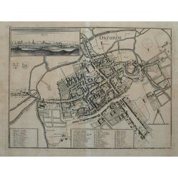
Oxforde.
Superbly detailed plan of Oxford with hundreds of tiny buildings, numerous fields, and rivers. With 48 places, streets, bridges, churches, and colleges identified through...
Date: Frankfurt, c1650
Selling price: ????
Please login to see price!
Sold in 2015
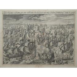
Classis Hispanica celeberrima, quae anno celeberrimo. MDLXXXVIII. inter Galliam Brittaniamque venit. & perijt.
Scene of the great sea battle in 1588 between Calais and Dover. Filled with fighting sailing ships, some already sinking with survivors being rescued.
Date: Amsterdam, c1650
Selling price: ????
Please login to see price!
Sold in 2015
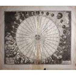
Tabula Anemogra Phica seu Pyxis Nautica Ventorum Nomina Sex Linguis Repraesentans
One of the earliest wind rose charts to appear in the 17th century. This unusual chart represents the evolution from the wind rose to the compass rose. Early mariners nam...
Date: Amsterdam, 1650
Selling price: ????
Please login to see price!
Sold in 2017
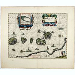
Moluccae Insulae Celeberrimae.
Showing the geographical features of the islands, and decorated with ships, rhumb lines, ships and sea monsters and a handsome cartouche. With an inset of Bachian island....
Date: Amsterdam, ca. 1650
Selling price: ????
Please login to see price!
Sold in 2017
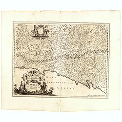
Riviera di Genova di Levante.
Detailed map of the Gulf of Genoa, including the towns of Genoa and La Spezia. Genoa was the birthplace of Christopher Columbus.
Date: Amsterdam, 1650
Selling price: ????
Please login to see price!
Sold in 2015
Beauvaisis, Comitatus Belovacium
A pleasing map of the Beuavais region of France. Decorative title cartouche with royal arms and drapery style scale cartouche with compass. Johannes Janssonius (1588-16...
Date: Amsterdam, 1650
Selling price: ????
Please login to see price!
Sold in 2018
Tartaria sive Magni Chami Imperium
A pleasing example of Blaeu's map of Tartary (Siberia) and Central Asia, extending from Mongolia and Xanadu to the Caspian and the Volga River, and to Tibet and the Upper...
Date: Amsterdam, c1650
Selling price: ????
Please login to see price!
Sold in 2016
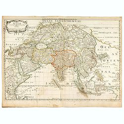
Asie.
Landmark map of Asia, it is the first French map to depict significantly new information. The map is known in one state. The map was prepared and issued separately in 165...
Date: Paris, 1650
Selling price: ????
Please login to see price!
Sold in 2016
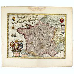
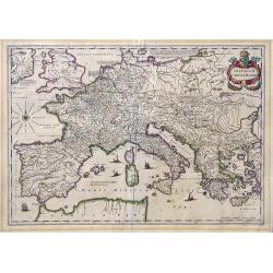
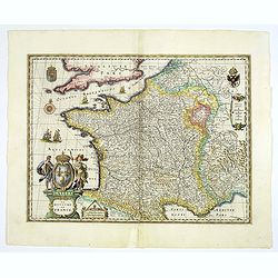
GALLIA. Le royaume de France.
The map was first published with figured borders (1607). When Blaeu needed a folio size map of France for his first atlas (Appendix 1631) he cut off the borders. The same...
Date: Amsterdam, 1650
Selling price: ????
Please login to see price!
Sold in 2016
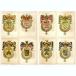
Eight woodcut printed coats of arms.
Eight wood cut printed coats of arms in very fine contemporary coloring. On verso and decorated oval with name. Including, Henry de Lenoncourt, Antoine Levy, Charles Robe...
Date: France, ca. 1650
Selling price: ????
Please login to see price!
Sold in 2018
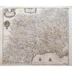
Languedoc
A great map of southern France from Perpignan to just east of the mouth of the Rhone river, until Étang de Berre. Filled with place names, including Avignon, Arles, Caho...
Date: Amsterdam, ca. 1650
Selling price: ????
Please login to see price!
Sold in 2016
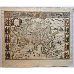
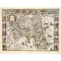
Asia Noviter Delineata.
This is one of the most famous 17th century maps of the continent of Asia. It is surrounded in a beautiful carte-a-figures border and is richly ornamented with animals, s...
Date: 1650
Selling price: ????
Please login to see price!
Sold in 2016
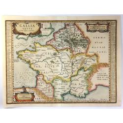
Gallia Vetus ad Iuly Caesaris Commentaria
This striking map of Gallia (ancient France) by Jan Jansson is based on information from Caesar's “De Bello Gallico". It is engraved to show the mountains, rivers ...
Date: Amsterdam, 1650
Selling price: ????
Please login to see price!
Sold in 2016
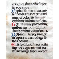
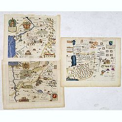
Leaf on vellum from a manuscript Missal or Antiphonary.
Very large hand vellum leaf with handwritten text. Several initials hand-painted in red and blue. With 15 lines of text on both sides. Probably from a Missal or Antiphona...
Date: France, ca. 1650
Selling price: ????
Please login to see price!
Sold in 2016
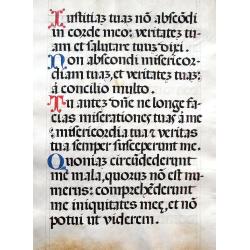
Leaf on vellum from a manuscript Missal or Antiphonary.
Very large hand vellum leaf with hand written text. Several initials hand painted in red and blue. With 15 lines of Latin text on both sides. Probably from a book written...
Date: France, ca. 1650
Selling price: ????
Please login to see price!
Sold in 2016
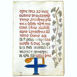
Italian manuscript leaf on vellum.
This is an handwritten page from the 1300 done in Italy. The marginal drawing of grapes done in the 1600's. It is written in a Gothic hand on fine Italian vellum.
Date: Italy 1300s with the drawing c.1650
Selling price: ????
Please login to see price!
Sold in 2017
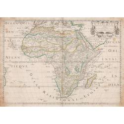
Africae nova descriptio.
Fine and important "carte à figures"- map of Africa. Much of the geographical information is still based on the Ptolemaic maps, with the Nile shown with its so...
Date: Amsterdam, 1650
Selling price: ????
Please login to see price!
Sold
Magni Mogolis Imperium.
An attractive map of the region from Iran through Tibet, and northern India to Burma. The travel route from Kabul to Surat is the most prominent feature of the map. Richl...
Date: Amsterdam, 1650
Selling price: ????
Please login to see price!
Sold in 2022
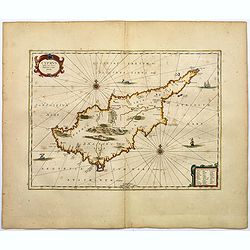
Cyprus Insula laeta choris, blandorum et mater amorum.
A classical map of Cyprus from Janssonius' historical atlas "Accuratissima Orbis Antiqui". With a rococo style title cartouche and similar explanation table in ...
Date: Amsterdam, ca 1650
Selling price: ????
Please login to see price!
Sold in 2017
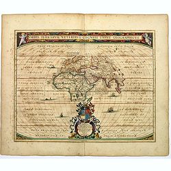
Orbis Terrarum Veteribus Cogniti Typus Geographicus.
A standard map of the world, according to the ancients, by Jansson, published in the mid seventeenth century, but based on earlier works by Ortelius.The map covers Europe...
Date: Amsterdam, ca 1650
Selling price: ????
Please login to see price!
Sold in 2017
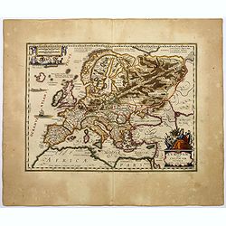
Europam, sive Celticam Veterem.
A map of the Celtic Empire by A. Ortelius, and reissued by Jansson in the middle of the seventeenth century. Ortelius' map first appeared in 1595.The map shows the contin...
Date: Amsterdam, ca 1650
Selling price: ????
Please login to see price!
Sold in 2017
Britannia prout divisa suit temporibus Anglo-Saxonum, praesertim durante illorum Heptarchia.
A very decorative map of England, Scotland and Wales. Wales and Scotland have their own kingdoms, however, England is divided up into seven separate Saxon kingdoms.Northu...
Date: Amsterdam, ca 1650
Selling price: ????
Please login to see price!
Sold in 2018
GALLIA. Le royaume de France.
Engraved by the master engraver Josua van den Ende. A very attractive map of France, embellished with a beautiful title cartouche at lower left, two royal shields in the ...
Date: Amsterdam, 1650
Selling price: ????
Please login to see price!
Sold in 2018

Petrus Bertius Collegii, Illustr ordinum Regens.
Copper engraving portrait of the famous geographer Petrus Bertius (1565 -1629). Bertius grew up in Beveren (Flanders, Belgium). As young man he travelled extensively thro...
Date: ca. 1650
Selling price: ????
Please login to see price!
Sold in 2017
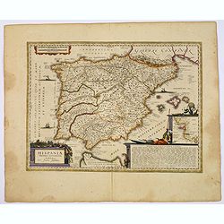
HISPANIAE Veteris descriptio.
A decorative handcolored copper engraved map, Latin text edition of J. Jansson's’ Historical Atlas'.
Date: Amsterdam ca. 1650
Selling price: ????
Please login to see price!
Sold in 2018
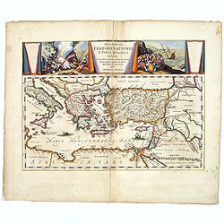
Descriptio Peregrinationis D. Pauli, Apostoli. . .
A striking map of the Mediterranean Sea and its surrounding areas. It depicts the travels of the Apostle St. Paul.The pair of decorative cartouches, presented in a curtai...
Date: Amsterdam, 1650
Selling price: ????
Please login to see price!
Sold in 2017
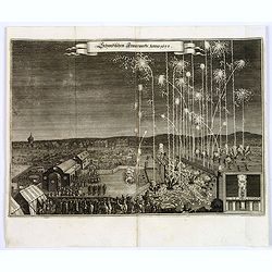
Schwedischen Feiverwerks, Anno 1650,
A night time fireworks display watched by an enthusiastic crowd, a print by M.Merian, published in his "Theatrum Europaeum." Banner title in German.
Date: Frankfurt am Main, 1650
Selling price: ????
Please login to see price!
Sold in 2019
![[Frontispiece] 'Theatrum Orbis Terrarum sive Atlas Novus. Partis Primae Pars'.](/uploads/cache/98686-250x250.jpg)
[Frontispiece] 'Theatrum Orbis Terrarum sive Atlas Novus. Partis Primae Pars'.
Frontispice from 'Theatrum Orbis Terrarum sive Atlas Novus. Partis Primae Pars'. Johan Blaeu succeeded his father Willem when the latter died in 1638. Johan led the Blaeu...
Date: Amsterdam, ca 1650
Selling price: ????
Please login to see price!
Sold in 2020
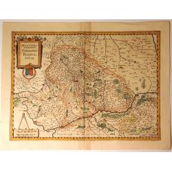
Tertia Pars Brabantiae. . .
A striking map showing part of present-day Belgium and Dutch Brabant. West is at the top. At the lower left the cartouche is embellished with male figures with compasses,...
Date: Amsterdam, 1650
Selling price: ????
Please login to see price!
Sold in 2018
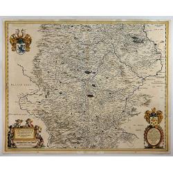
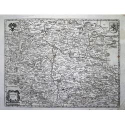
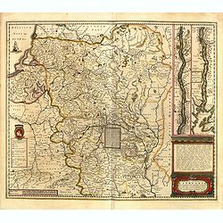
Thuringia Landgraviatus.
A detailed map of Thuringa in central Germany, centred on Erfurd on the middle of the map. Showing also Weimar. Embellished with a very decorative title cartouche that is...
Date: Amsterdam, 1650
Selling price: ????
Please login to see price!
Sold in 2018
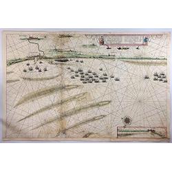
Afbeeldinge Vande vermaerde Seehaven ... Duynkerken...
A striking coastal chart, extending from Dunkerque and Wynoxbergen to in the east to Waldarn and Gravelines in the west, with an inset showing the continuation of the coa...
Date: Amsterdam, 1650
Selling price: ????
Please login to see price!
Sold in 2018

'Peacocks'.
A copper engraving. Print showing peacocks in different poses.
Date: English, ca 1650
Selling price: ????
Please login to see price!
Sold in 2020
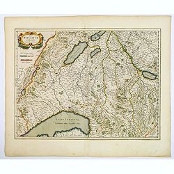
Das Wiflispurgergow.
A lovely detailed map of South-western Switzerland after Gerhard Mercator's map of the same. With an ornamental title cartouche and Dutch text on the verso. It shows Gene...
Date: Amsterdam, ca 1650
Selling price: ????
Please login to see price!
Sold in 2018
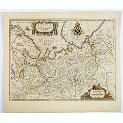
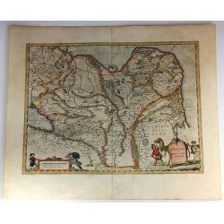
Russiae vulgo Moscovia dictae, Partes Septentionalis et Orientalis.
Covers the northern part of Russia from Finland to just beyond the Jenisej River and south to the Volga River. Includes the cities of Jaroslavl, Niznij Novgorod, and Kaza...
Date: Amsterdam, ca 1650
Selling price: ????
Please login to see price!
Sold in 2019
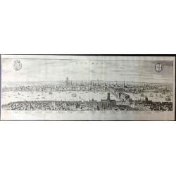
London.
A beautifully engraved panorama of London during the reign of James I which was based on an earlier Visscher engraving published in 1616.Merian's panorama shows London fi...
Date: London, 1650
Selling price: ????
Please login to see price!
Sold in 2019
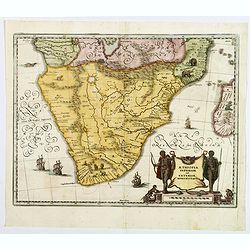
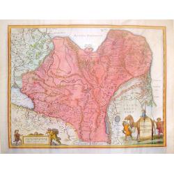
Aethopia Inferior vel Exterior Monomotapa.
A very attractive map of the African region south of the Congo, probably derived from Blaeu, and based on Portuguese exploration. The interior is filled with indigenous ...
Date: Frankfurt ca 1650
Selling price: ????
Please login to see price!
Sold in 2018
Magni Mogolis Imperium.
An attractive map of the region from Iran through Afghanistan, Tibet, and northern India across to Burma. The travel route from Kabul to Surat is the most prominent featu...
Date: Amsterdam, 1650
Selling price: ????
Please login to see price!
Sold in 2018