Browse Listings
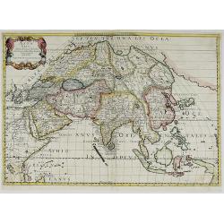
Asia Vetus Autore N. Sanson Abbavillæo Christianiss. . .
A striking and highly detailed unusual double page copper engraved map of the Asian Continent at the time of the ancients. The East Indies and northern part of Papua-New ...
Date: Paris, 1650
Selling price: ????
Please login to see price!
Sold in 2019
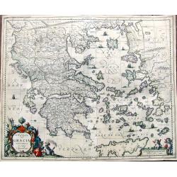
Hellas. seu Graecia Universa. Autore J. Laurenbergio.
Fine map of Greece with Crete, the Carpathian Sea, the islands west of Peloponesia, the Aegean Sea, and a part of Turkey. Richly detailed with towns, rivers, and topograp...
Date: Amsterdam, ca. 1650
Selling price: ????
Please login to see price!
Sold in 2019
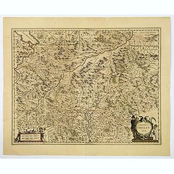
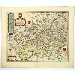
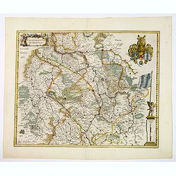
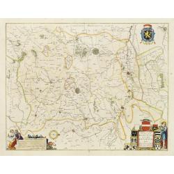
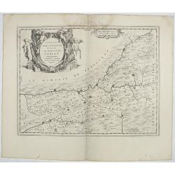
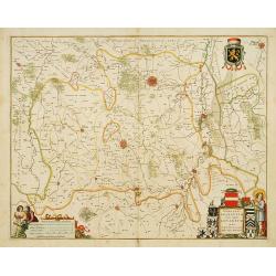
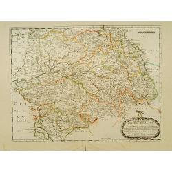
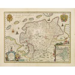
Comitatus Tirolensis.
A detailed map of the west Austrian Tirol region, with plenty of excellent topographical detail in the rendering of the numerous mountains, rivers, forests, larger towns,...
Date: Amsterdam, ca 1650
Selling price: ????
Please login to see price!
Sold in 2019
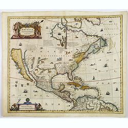
America Septentrionalis.
A wonderful map showing California as an island, and above, the northwest of the continent is left blank except for two paragraphs explaining the discoveries to date. Int...
Date: Amsterdam, ca 1650
Selling price: ????
Please login to see price!
Sold in 2019
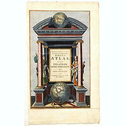
Joannis Janssonii Novus Atlas, sive Theatrum Orbis Terrarum: in quo Orbis Antiquus. . .
A glorious mid-seventeenth century engraved frontispieces to atlas by Janssonius. Finely decorated with a pair of terrestrial (bottom) and celestial (top) globes and the ...
Date: Amsterdam, 1650
Selling price: ????
Please login to see price!
Sold in 2024
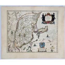
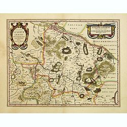
China veteribus Sinarum Regio nuc incolis Tame dicta.
A very fine example of this classic 17th century map, and Blaeu’s first of China, in attractive strong original color. The map further shows the whole of Japan, the 'is...
Date: Amsterdam, 1650
Selling price: ????
Please login to see price!
Sold in 2020
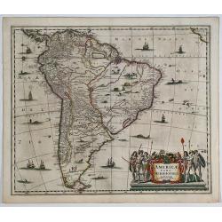
Americae Pars Meridionalis.
A finely engraved map of South America. One of the earliest separate maps of South America, and one of the first decorative maps of South America to appear in a Dutch Atl...
Date: Amsterdam, 1650
Selling price: ????
Please login to see price!
Sold in 2019
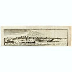
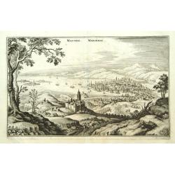
Avignon.
Detailed bird's-eye view of the town of Avignon.
Date: Frankfurt 1650
Selling price: ????
Please login to see price!
Sold in 2020
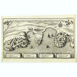
Abriß der Dreÿen, gegeneinander correspondierenden Vestungen, Monaco, Capo di Sant' Spirito, und Niza di Provenza. (Monaco)
Beautiful map showing the coasts of Provence, with detailed plans of Nice, Villefranche-sur-Mer, the peninsula of Cap Ferrat and Monaco, from the from the Theatrum Europ�...
Date: Frankfurt, ca. 1650
Selling price: ????
Please login to see price!
Sold in 2019
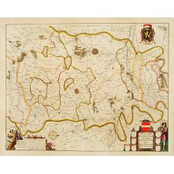
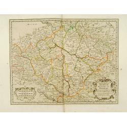
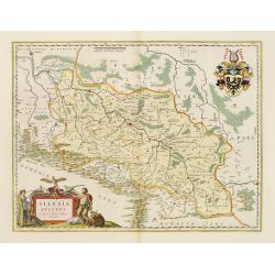
Silesia Inferior. . .
A fine and decorative map of lower Silesia (western Poland), centred on Glogau, the capital of Breslaw (Wroclaw) is found not far away. Each major city in the region is c...
Date: Amsterdam, 1650
Selling price: ????
Please login to see price!
Sold in 2019
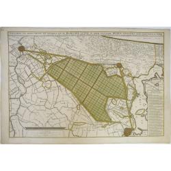
Afbeeldinge van Zeker Concept tot Bedykinge, van de Haarlemer, Leydse en Andere byleggende Meeren.
Large, rare, and detailed map of the region between Amsterdam, Haarlem and Leiden, from two copperplates. It concerns a concept to reclaiming the Haarlemmermeer, drawn by...
Date: Amsterdam, 1650
Selling price: ????
Please login to see price!
Sold in 2019
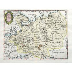
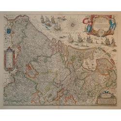
Russie Blanche ou Moscovie. . .
An unusual map of eastern Europe and western Russia. With two pages of descriptive text in French about the area on verso. Includes many cities and towns, rivers, and reg...
Date: Paris, ca 1650
Selling price: ????
Please login to see price!
Sold in 2019
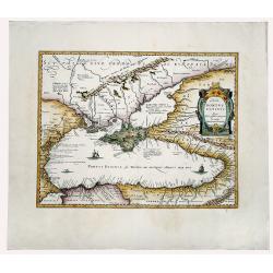
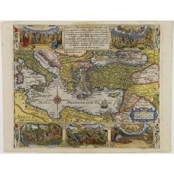
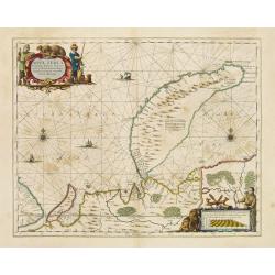
ΠΟΝΤΟΣ ΕΥΞΕΙΝΟΣ. PONTUS EUXINUS.
A striking example of the map depicting the Black Sea and the Crimean Peninsula with its surrounding regions. Covers parts of the Ukraine, Russia, Georgia, Romania and Tu...
Date: Amsterdam, ca 1650
Selling price: ????
Please login to see price!
Sold in 2020
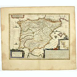
HISPANIAE Veteris descriptio. Abraham Goos Sculpsit.
A decorative handcolored copper engraved map, Latin text edition of J. Jansson's’ Historical Atlas'. A very handsome and decorative map of ancient Spain based on classi...
Date: Amsterdam ca. 1650
Selling price: ????
Please login to see price!
Sold in 2019

Duche et Gouvernement de Bretagne.
A probable first state of this decorative regional French map of Bretagne, including the cities of Nantes, Rennes, Belle-Île, St. Malo, Pontivy, Morlaix, Brest and Vanne...
Date: Paris, 1650
Selling price: ????
Please login to see price!
Sold in 2019
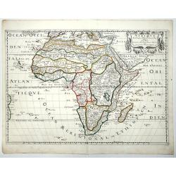
AFRIQUE par N. Sanson d'Abbeville.
According to Betz, this is a landmark map of Africa, It is the first French map to depict significantly new information. The map is known in one state. The map was prepar...
Date: Paris, 1650
Selling price: ????
Please login to see price!
Sold in 2019
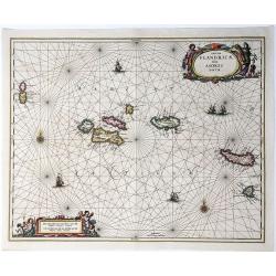
Insulae Flandricae, olim Asores dictae.
A scarce colored sea chart of part of the Atlantic Ocean: the Azores islands ((Faial, Pico, Graciosa, Terceira, Sao Jorge, Formigas, São Miguel), published by Johannes J...
Date: Amsterda, 1650
Selling price: ????
Please login to see price!
Sold in 2020
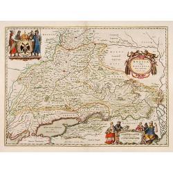
Palatinatus ad rhenum.
A beautiful, detailed map of the south western province of Rhineland-Palatinate in Germany by Blaeu, one of the most famous of all map publishers.A decorative map, coveri...
Date: Amsterdam, ca 1650
Selling price: ????
Please login to see price!
Sold in 2020
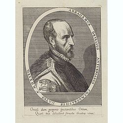
Abrahamus Ortelius Antuerpianus cosmographus natus a. MDXXVII
Portrait of Abraham Ortelius (Abraham Ortel), famous cartographer born in Antwerp and after studying Greek, Latin and mathematics set up a business there with his sister,...
Date: Antwerp, c.1650
Selling price: ????
Please login to see price!
Sold in 2023
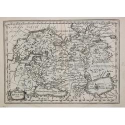
Russiae, vulgo Moscovia, pars Australis.
Centered on Moscow. Prepared by Isaac Massa, a Dutch mapmaker who travelled to Russia, returning to Holland in 1609, bringing with him a large amount of original cartogra...
Date: Amsterdam 1650
Selling price: ????
Please login to see price!
Sold
Iprensis Episcopatus.
Map of the Dioceses of Ypres (1559-1801). Centered on the towns of Ypres and Rouselare.Rare map only included in Joan Blaeu's Atlas Major. Originally engraved for Sanderu...
Date: Amsterdam, 1650
Selling price: ????
Please login to see price!
Sold in 2020
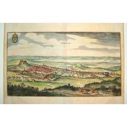
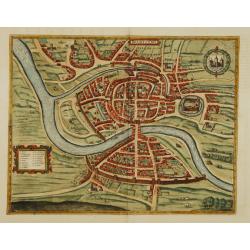
Edynburgum
A beautifully rendered 17th century view of Edinburgh. Provides excellent detail, with many of the town's key sites visible. The Scottish coat of arms is shown in the upp...
Date: Frankfurt, 1650
Selling price: ????
Please login to see price!
Sold
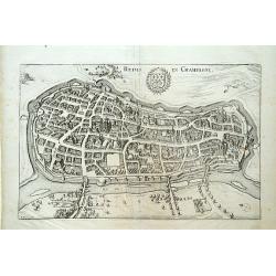
Reims en Champagne.
Detailed bird's-eye view of the town of Rheims. From Merian's Theatrum Europaeum. To the bottom a lettered key to the principal places in town.
Date: Frankfurt 1650
Selling price: ????
Please login to see price!
Sold
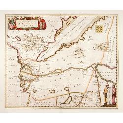
Nova Aegypti Tabula.
With an ornate cartouche and two surveyors supporting the mileage scale.
Date: Amsterdam, 1650
Selling price: ????
Please login to see price!
Sold in 2011
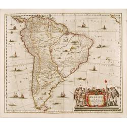
Americae pars meridionalis.
Decorated with several ships and sea monsters, and a cartouche flanked by engravings of six Indians, netted hammocks and South American fauna.
Date: Amsterdam 1650
Selling price: ????
Please login to see price!
Sold
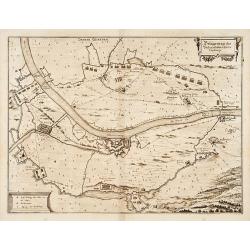
Belägerung des Vesten.. Gennep.
Detailed map of the siege of Gennep.
Date: Frankfurt 1650
Selling price: ????
Please login to see price!
Sold
Prima pars Brabantiae cuius caput Lovanium.
Decorative map centred on Tienen and Leuven. West to the top.
Date: Amsterdam 1650
Selling price: ????
Please login to see price!
Sold in 2018
Angelus Tobiam liberat ne deuoretur a pisce Tob.6.
Illustration of the history of Tobias. engraving number 4.The angel saving Tobias from being devored by the whale.
Date: Southern Netherlands c.1650
Selling price: ????
Please login to see price!
Sold
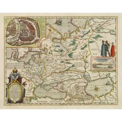
Novus XVII Inferioris Germanie Provinciarum Typus
This is undoubtedly one of the most magnificent maps of the seventeen provinces of the Netherlands. It was first produced as a separately issued wall map in 1608 with fig...
Date: Amsterdam, 1650
Selling price: ????
Please login to see price!
Sold in 2010
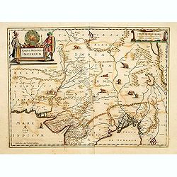
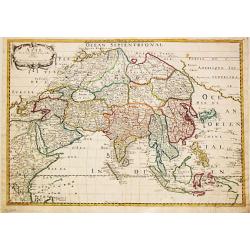
Magni Mogolis Imperium.
A most attractive map of northern India and Central Asia.
Date: Amsterdam, 1650
Selling price: ????
Please login to see price!
Sold
Titlepage: Studium Geographicum.
Uncommon title page by the Rome publisher Joannis Baptistae Nicolosi (active 1610-1670).
Date: Rome, 1650
Selling price: ????
Please login to see price!
Sold
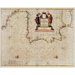
Pascaart vande Custen van Andaluzia, Portugal..
Decorative chart of the coasts of Andalusia, Portugal, Galicia, Biscayne from the first sea-atlas (in the real sense of the word) printed in the Netherlands.
Date: Amsterdam 1650
Selling price: ????
Please login to see price!
Sold
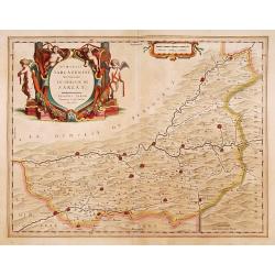
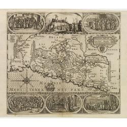
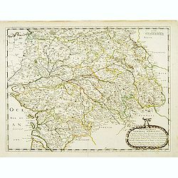
Dioecesis Sarlatensis, vernacule
Detailed map of Perigord, depicting Bergerac, Saint Cyprien, Montignac, Sarlat, Villefranche, etc. Embellished with an enormous and beautiful title cartouche in the left ...
Date: Amsterdam 1650
Selling price: ????
Please login to see price!
Sold
Dioecesis Sarlatensis, vernacule... Sarlat.
Impressive title cartouche with four putti. Detailed map of the region south of the Dordogne River from Bergerac till Saint-Cirq. Including Le Buisson.
Date: Amsterdam 1650
Selling price: ????
Please login to see price!
Sold in 2009
Prima pars Brabantiae cuius caput Lovanium.
Decorative map centered on Tienen and Leuven. West to the top.
Date: Amsterdam, 1650
Selling price: ????
Please login to see price!
Sold in 2018
No title. Map of the Holy Land.
Engraved by Baptista van Doetechum for a bible by Plancius.The rare re-issue by Joost Hartgers. The bible maps of Plancius came into the hands of the Amsterdam publisher ...
Date: Amsterdam 1650
Selling price: ????
Please login to see price!
Sold
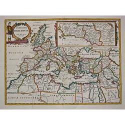
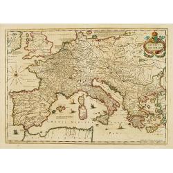
Imperium Romanum. Auth. Phil. Briet e Societ Iesu.
Philip Briet S.J. (1601-1668). French cartographer. Parallela Geogr. Veterus et Novae 1648, Atlas 1653.A map depicting the Roman Empire with an inset showing Rome and its...
Date: Paris, c. 1650
Selling price: ????
Please login to see price!
Sold
Prima pars Brabantiae cuius caput Lovanium.
Decorative map centered on Tienen and Leuven. West to the top. Prepared by Michael Floris van Langeren (1612-1675). He was an mathematician and astronomer who served for ...
Date: Amsterdam 1650
Selling price: ????
Please login to see price!
Sold
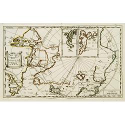
Pais qui dependent de la Norvege suivant les derniers relations.
Rare map of the North Pole. With inset maps of Faeroe and Shetland Islands.
Date: Paris 1650
Selling price: ????
Please login to see price!
Sold
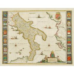
Regno di Napoli.
To the left and right 12 coats of arms of different regions. From a German text edition.
Date: Amsterdam 1650
Selling price: ????
Please login to see price!
Sold
Gouvernement General d'Orleans ..
Fine map of south eastern part of France, including Isle de Ré, Paris, S.Malo, etc. This edition carries the date 1650 and the cartouche presents the address of Pierre M...
Date: Paris, 1650
Selling price: ????
Please login to see price!
Sold
Imperium Caroli Magni
Finely engraved map of the Empire of Karol the Great.
Date: Amsterdam 1650
Selling price: ????
Please login to see price!
Sold
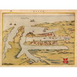
Malta.
Attractivetown-plan of Valetta on Malta, based on the engraving in Braun and Hogenberg' townbook from 1572-1624.A schematic drawing shows Valetta with a strongly fortifie...
Date: The Netherlands ? 1650
Selling price: ????
Please login to see price!
Sold
Gouvernement General d'Orleans ..
Fine map of south eastern part of France, including Isle d'Ré, Paris, S.Malo, etc.This edition carries the date 1650 and the cartouche presents the address of Pierre Mar...
Date: Paris 1650
Selling price: ????
Please login to see price!
Sold
Royaume de Boheme.
Covering Czech Republic and cantered on Prague.This edition carries the date 1650. Nicolas Sanson was to bring about the rise of French cartography, although the fierce c...
Date: Paris 1650
Selling price: ????
Please login to see price!
Sold
Typus Frisiae Orientalis.
Decorative map of east Frisia in Germany with the Watten islands. With inset map of the area south of Emden. Prepared by Ubbo Emmius (1547-1625).
Date: Amsterdam, 1650
Selling price: ????
Please login to see price!
Sold in 2018
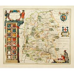
Wiltopnia sive comitatus Wiltoniensis, Anglis Wilshire.
A fine copy of this famous and decorative map of Wiltshire. 16 shields, two left blank underneath the decorated cartouche at top left. Two more shields at right, secondar...
Date: Amsterdam 1650
Selling price: ????
Please login to see price!
Sold
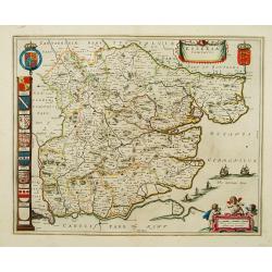
Essexia comitatus.
A fine copy of this famous and decorative map of Essex. Title banner, scale cartouche with three putti. Royal Arms, Arms of England and A panel displaying seven coats of ...
Date: Amsterdam 1650
Selling price: ????
Please login to see price!
Sold
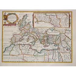
Imperium Romanum. Auth. Phil. Briet e Societ Iesu.
Philip Briet S.J. (1601-1668). French cartographer. Parallela Geogr. Veterus et Novae 1648, Atlas 1653.A map depicting the Roman Empire with an inset showing Rome and its...
Date: Paris, c. 1650
Selling price: ????
Please login to see price!
Sold
Novissima Russiae Tabula.
Johannes Janssonius, the great rival of Willem Blaeu, was the son-in-law of Jodocus Hondius. Together with Jodocus' son Hendrick, he continued to publish the successive e...
Date: Amsterdam, c. 1650
Selling price: ????
Please login to see price!
Sold
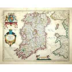
Hibernia regnum vulgo Ireland
A good and dark impression of a cornerstone map of Ireland, with three decorative cartouches in full original color.
Date: Amsterdam, 1650
Selling price: ????
Please login to see price!
Sold
Brightstowe.
An very attractive town plan of Bristol with in the upper right corner coat of arms. Lower left a key to the principal buildings of the city.Brightstowe (meaning pleasant...
Date: Amsterdam 1650
Selling price: ????
Please login to see price!
Sold
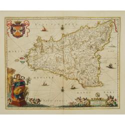
Sicilia Regnum.
Sought-after map of Sicily by one of Holland's most famous publishers. Very nice title cartouche, scale and coat-of-arms.
Date: Amsterdam 1650
Selling price: ????
Please login to see price!
Sold
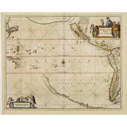
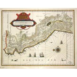
Mar del Zur, Hispanis Mare Pacificum.
Jansson's fine map of the Pacific including the west coast of America with California shown as an island, Japan and a small Australian coastline. This is one of the earli...
Date: Amsterdam 1650
Selling price: ????
Please login to see price!
Sold
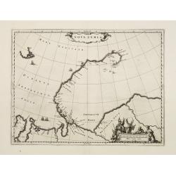
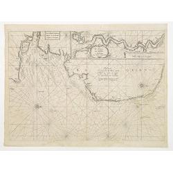
Nova Zemla
The Dutch were the most persistent searchers after the north-east Passage, whether to the north of Novaya Zemlya (whose west coast is shown in detail) or through what the...
Date: Amsterdam 1650
Selling price: ????
Please login to see price!
Sold
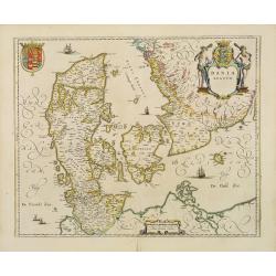
Dania Regnum.
Standard map of Denmark with fine title cartouche and coat of arms.
Date: Amsterdam 1650
Selling price: ????
Please login to see price!
Sold
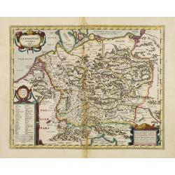
Germaniae Veteris typus.
Map made on the basis of the writings by the ancient authors Tacitus, Caesar, Dionysus, Ptolemy, Suetonius, Eutropius, Seneca, Plinius and Strabo.Showing an substantial p...
Date: Amsterdam 1650
Selling price: ????
Please login to see price!
Sold
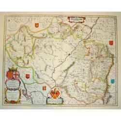
ARRAGONIA REGNUM
A highly decorative map of the historically significant Spanish province of Arragon. Features two elaborate cartouches and several coats of arms, identifying surrounding ...
Date: Amsterdan, c. 1650
Selling price: ????
Please login to see price!
Sold
Imperii Caroli Magni.
Prepared by Petrus Bertius in 1616. Very large historical map (four sheets joined) depicting the empire of Charles the Great. Fully engraved with mountains, forests, and ...
Date: Amsterdam 1650
Selling price: ????
Please login to see price!
Sold
Tabula Geographica in qua omnes regiones, urbes..
Engraved by Baptista van Doetechum for a bible by Plancius.The rare re-issue by Joost Hartgers. The bible maps of Plancius came into the hands of the Amsterdam publisher ...
Date: Amsterdam 1650
Selling price: ????
Please login to see price!
Sold in 2009
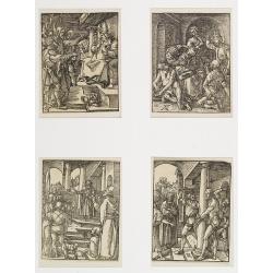
Four woodcuts by Albrecht Dürer.
Christ before Caiphas (Bartsch 29). The mocking of Christ (Bartsch 30). Christ before Pilate (Bartsch 31). The scourging of Christ (Bartsch 33). All woodcuts on paper
Date: Germany , probably ca. 1650
Selling price: ????
Please login to see price!
Sold
Peru.
Johan Blaeu succeeded his father Willem when the latter died in 1638. Johan led the Blaeu firm to its greatest achievement the ' Atlas Maior' in 12 parts, the greatest an...
Date: Amsterdam, c. 1650
Selling price: ????
Please login to see price!
Sold in 2020
Pascaerte Vertoonende de Mont Vande Teemse en Voort de Custe van Engelandt tot Crammer.
Fine map depicting the English shores between Cromer in the Norfolk and North Foreland in Kent. West to the top.Additional title: Les Costes d?Engleterre depuis le Voorla...
Date: Amsterdam 1650
Selling price: ????
Please login to see price!
Sold
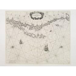
De Cust van Finmarcken tusschen Dronten en Sanien.
Uncommon chart of the coasts of Finnmark, centered on the Moskstraumen (popularly known as the Maelstrom) one of the strongest whirlpools in the world, that forms in a st...
Date: Amsterdam 1650
Selling price: ????
Please login to see price!
Sold
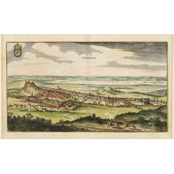
Edynburgum.
Detailed bird's-eye view of the town of Edenburg. From Merian's Theatrum Europaeum.
Date: Frankfurt 1650
Selling price: ????
Please login to see price!
Sold
Ducatus Luneburgensis..
Very detailed map centered on Albis river and the cities of Hamburg and Lunburg to the north. Also showing Bremen. Very decorative title cartouche. Scale cartouche embell...
Date: Amsterdam, 1650
Selling price: ????
Please login to see price!
Sold
![Lvnden [London]](/uploads/cache/11229-250x250.jpg)
Lvnden [London]
Decorative panoramic view London. With extensive shipping in river Themes. Very decorative and of the highest standing of engraving.
Date: Frankfurt 1650
Selling price: ????
Please login to see price!
Sold
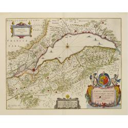
Lacus Lemanni Locorumque circumiacentium Accuratissima. . .
Row boats and sailing vessels dot the surface of Lake Geneva, which is further enhanced by a compass rose radiating rhumb lines. The lake is surrounded by mountains and f...
Date: Amsterdam, 1650
Selling price: ????
Please login to see price!
Sold in 2017
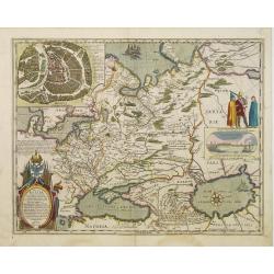
Tabula Russiae.
A re-issue, by Willem Blaeu, of Hessel Gerritsz' rare and influential map of Russia. This fine map was compiled from manuscripts brought back from Russia, by Isaac Massa ...
Date: Amsterdam 1650
Selling price: ????
Please login to see price!
Sold
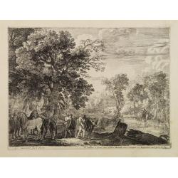
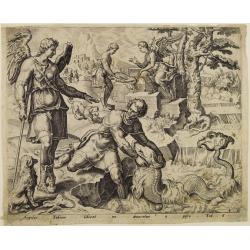
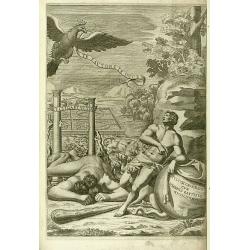
Mercury guarding the horses of Apollo.
Etching of a wooded landscape with Mercury guarding the horses of Apollo. Signed in the plate "H:Swanevelt fecit Rome", edited and sold by Pierre Mariette in Pa...
Date: Rome ca. 1650
Selling price: ????
Please login to see price!
Sold in 2008
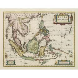
Indiae Orientalis nova descriptio.
An important map of South East Asia, noteworthy for being amongst the first maps to include any information on the discoveries made by the Dutch vessel Duyfkens in New Gu...
Date: Amsterdam 1650
Selling price: ????
Please login to see price!
Sold
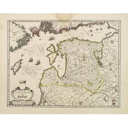
Livonia vulgo Lyefland.
Blaeu's map of Livonia, embellished with a decorative title-cartouche, vessels and 7 coats of arms.
Date: Amsterdam 1650
Selling price: ????
Please login to see price!
Sold
Capitaniarum de Phernambuca, Itamaraca, Paraiba..
Rare map of part of the coast of Brazil. Much information is derived from maps drawn for the Dutch West Indian Company.Published by the famous Amsterdam publisher Johanne...
Date: Amsterdam 1650
Selling price: ????
Please login to see price!
Sold
Insula S.Iuan de Puertorico caribes vel Canibasun insulae.
Interesting map of the Lesser Antilles, from Porto Rico as far as Trinidad & Tobago and the South American coast. North is orientated to the left of the page.With a s...
Date: Amsterdam 1650
Selling price: ????
Please login to see price!
Sold
Nova Zemla..
The Dutch were the most persistent searchers after the north-east Passage, whether to the north of Novaya Zemlya (whose west coast is shown in detail) or through what the...
Date: Amsterdam 1650
Selling price: ????
Please login to see price!
Sold
Asie.
Nicolas Sanson (1600-67), ' father of the French cartography' and founder of the Sanson firm. Atlas ' Cartes générales de toutes les parties du Monde', 1658-70 and a po...
Date: Paris, 1650
Selling price: ????
Please login to see price!
Sold in 2015
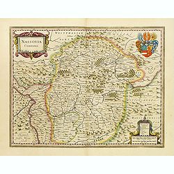
Nassovia Comitatus.
Beautiful map of Nassau, including Coblenz, Siegen, etc.
Date: Amsterdam, 1650
Selling price: ????
Please login to see price!
Sold
Silesia Ducatus..
Centered on Breslaw.
Date: Amsterdam, 1650
Selling price: ????
Please login to see price!
Sold in 2008
Massilia - Marseille.
Detailed bird's-eye view of the town of Marseille. From Merian's Theatrum Europaeum. To the bottom a lettered key to the principal places in town.
Date: Frankfurt 1650
Selling price: ????
Please login to see price!
Sold
Tabula Russiae.
A re-issue, by Willem Blaeu, of Hessel Gerritsz' rare and influential map of Russia. This fine map was compiled from manuscripts brought back from Russia, by Isaac Massa ...
Date: Amsterdam, 1650
Selling price: ????
Please login to see price!
Sold