Browse Listings
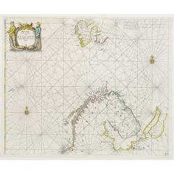
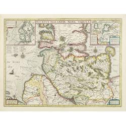
Pascaart Vande zeecusten van Ruslant, Laplant, Finmarcken en Spitzbergen.
It shows the most western part of Russia's north coast, the northernmost part of Scandinavia and Spitsbergen.
Date: Amsterdam 1650
Selling price: ????
Please login to see price!
Sold
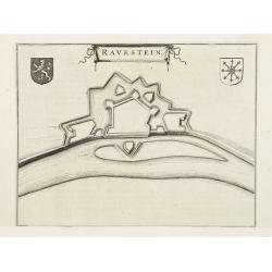
Ravenstein.
A bird's eye view engraving of the Dutch city of Ravenstein.Latin text on verso.
Date: Amsterdam 1650
Selling price: ????
Please login to see price!
Sold
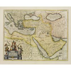
Turcicum Imperium.
An impressive and attractive map with a particularly fine cartouche showing the Turkish Sultan on his throne and allegorical figures at either side brandishing weapons.Sa...
Date: Amsterdam 1650
Selling price: ????
Please login to see price!
Sold
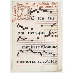
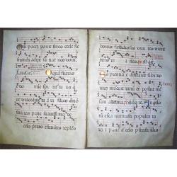
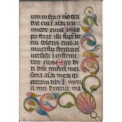
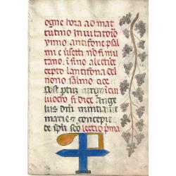
Leaf on vellum from an antiphonary.
A very fine antiphonary leaf, written in Latin, probably Rome. RECTO: A wonderful initial L, decorated with penwork in red and black.VERSO: The staves are in red and the ...
Date: Italy c. 1650
Selling price: ????
Please login to see price!
Sold
Two Consecutive Vellum Music Leaves with Gold Initials
Two large consecutive pages of an antiphoner, on vellum, with the initials filled in with gold leaf. Width and height is per lea
Date: Spain or Italy, ca. 1650
Selling price: ????
Please login to see price!
Sold
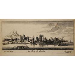
La Citta di Candia.
From 'Diverse viste delle cita in Candia, Malta, come nel Archipelago'. Etchings by Joh. Peeters, Gaspar Bouttats, Lucas Vorstermans and Coenraad Lauwers.A fine view of t...
Date: Antwerp, I. Peeters, c. 1650
Selling price: ????
Please login to see price!
Sold in 2020
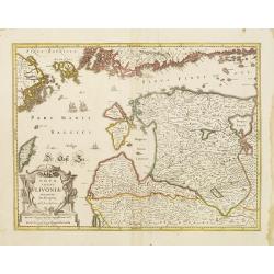
Nova Totius Livoniae accurata Descriptio.
Decorative map of Estonia and Latvia. Including the southern tip of Finland and the south eastern tip of Sweden, including Stockholm.
Date: Amsterdam 1650
Selling price: ????
Please login to see price!
Sold
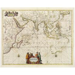
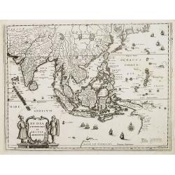
Mar di India.
This chart from Johannes Janssonius' sea-atlas 'De Water-Weereld' covers the area between the Cape of Good Hope and Japan.It owes its importance to the rendering of the c...
Date: Amsterdam 1650
Selling price: ????
Please login to see price!
Sold
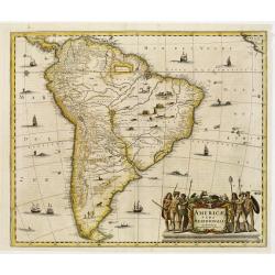
Americae Pars Meridionalis.
Finely engraved map of South America. Decorated with several ships and sea monsters, and a cartouche flanked by engravings of six Indians, netted hammocks and South Ameri...
Date: Amsterdam 1650
Selling price: ????
Please login to see price!
Sold
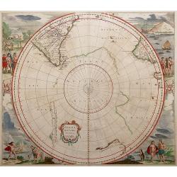
Polus Antarcticus.
Circular map with decorative illustrations in the four corners of the South Pole. From the German text edition of his Atlas of 1650.Third state with important changes: Th...
Date: Amsterdam, 1650
Selling price: ????
Please login to see price!
Sold in 2013
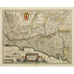
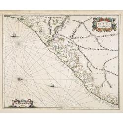
Riviera di Genova di Levante.
Detailed map of the Gulf of Genoa, including the towns of Genoa and La Spezia. Genoa was the birth place of Christopher Columbus.
Date: Amsterdam, 1650
Selling price: ????
Please login to see price!
Sold
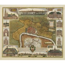
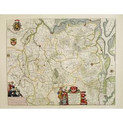
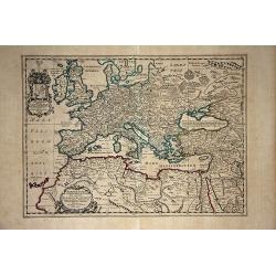
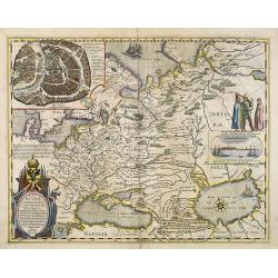
Marchionatus Sacri Romani Imperii.
In the centre a plan of the city of Antwerp with its surroundings. In numerous insets panoramic views of the harbour and parts of the city and pictures of the most import...
Date: Amsterdam, 1650
Selling price: ????
Please login to see price!
Sold
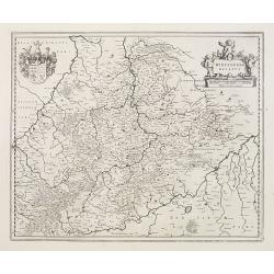
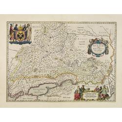
Wirtenberg Ducatus
Map depicting the area south of Heidelberg, including Stuttgart, Ulm, etc.. and river Danube.A beautiful coat of arms and a splendid title cartouche decorated by three ch...
Date: Amsterdam, 1650
Selling price: ????
Please login to see price!
Sold
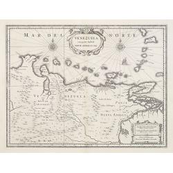
Venezuela cum parte Australi Novae Andalusiae.
A finely engraved, decorative map with Latin text on the reverse. The islands Trinidad, Margarita, Aruba, Bonaire and Curaçao are shown as well.
Date: Amsterdam, 1650
Selling price: ????
Please login to see price!
Sold
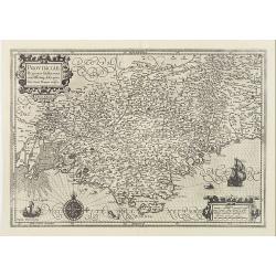
Provinciae, Regionis Galliae, vera exactissimaq. descriptio..
Detailed map of the Province prepared by Pierre-Jean de Bompar who published a single sheet map of the Province in 1591.Title cartouche on the upper left-hand corner. Eng...
Date: Amsterdam, 1650
Selling price: ????
Please login to see price!
Sold
Transylvania Sibenburgen.
Crisply engraved chart of Transylvania, today parts of Hungary and Romania. Nice detail of forested areas, mountain ranges, rivers and towns.Beautifully colored cartouche...
Date: Amsterdam 1650
Selling price: ????
Please login to see price!
Sold
Ducatus Holsatiae nova tabula.
Beautiful map of Schleswich Holstein with two insets.
Date: Amsterdam, 1650
Selling price: ????
Please login to see price!
Sold in 2011
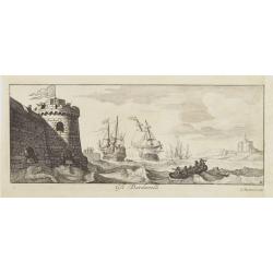
Gli Dardanelli.
The forts on the entrance of the Dardanelles. From ' Diverse viste delle cita in Candia, Malta, come nel Archipelago'. Etchings by Joh. Peeters, Gaspar Bouttats, Lucas Vo...
Date: Antwerp, ca 1650
Selling price: ????
Please login to see price!
Sold in 2008
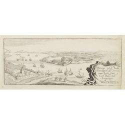
Diverse viste delli Dardaneli del Strecio come delle Città e Castelli nel'Arcipelago..
Bird's eye-view of the forts on the entrance of the Dardanelles strait. Engraved by I. Peeters.From ' Diverse viste delle cita in Candia, Malta, come nel Archipelago'. Et...
Date: Antwerp, ca 1650
Selling price: ????
Please login to see price!
Sold in 2008
![Cracovia. [Cracow]](/uploads/cache/24989-250x250.jpg)
Cracovia. [Cracow]
Panoramic view of Cracow with a numbered key (1-46) to the most interesting buildings in town.
Date: Frankfurt, c. 1650
Selling price: ????
Please login to see price!
Sold
Nova Aegypti Tabula.
With an ornate cartouche and two surveyors supporting the mileage scale.
Date: Amsterdam, 1650
Selling price: ????
Please login to see price!
Sold in 2008
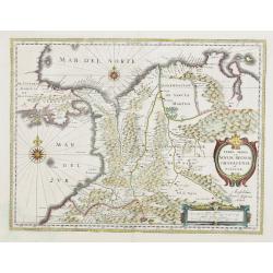
Terra Firma et Novum regnum Granatense et Propayan.
Fine copy, with wide margins of this handsome map of the Isthmus of Panama and northwestern South America including most of present day Columbia and part of Venezuela. Te...
Date: Amsterdam, 1650
Selling price: ????
Please login to see price!
Sold
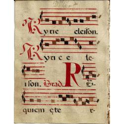
Manuscript Gradual Leaf
Single leaf from a Gradual Manuscript on vellum Spain, 17th C. The gradual is a liturgical book of texts and chants sung by the choir in response to the celebration of th...
Date: Spain, ca. 1650
Selling price: ????
Please login to see price!
Sold in 2008
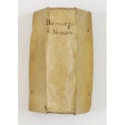
Historiae Universalis cum Sacraetum prophanae nucleus. . .
Charming universal history book with 15 charming wood cut engraved maps. The main copper engraved title page records Ulm under the title. This is the rare FIRST EDITION ...
Date: Ulm, Johannem Görlinum, 1650
Selling price: ????
Please login to see price!
Sold in 2008
Novissima Russiae Tabula.
An attractive small map of European Russia.Johannes Janssonius, the great rival of Willem Blaeu, was the son-in-law of Jodocus Hondius. Together with Jodocus\' son Hendri...
Date: Amsterdam c.1650
Selling price: ????
Please login to see price!
Sold in 2009
Tertia Pars Brabantiae.
West is at the top. At the lower left the cartouche embellished with male figures with compasses, globe, book and winckel-kruis . At bottom, right of the centre, a beauti...
Date: Amsterdam, 1650
Selling price: ????
Please login to see price!
Sold in 2008
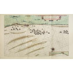
Afbeeldinge vande vermaerde seehaven .. Duynkerken..
Blaeu's chart of the coast of the French coast from Duinkerk till Waldamme. In an inset, lower right the continuation till Calais. Many ships offshore Duinkerk, with soun...
Date: Amsterdam, 1650
Selling price: ????
Please login to see price!
Sold in 2008
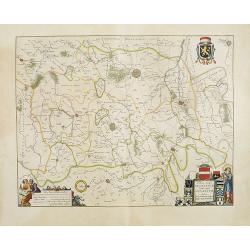
Prima pars Brabantiae cuius caput Lovanium.
Decorative map centered on Tienen and Leuven. West to the top.
Date: Amsterdam, 1650
Selling price: ????
Please login to see price!
Sold in 2008
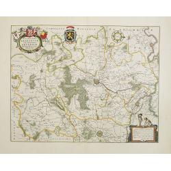
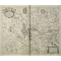
Secunda pars Brabantiae cuis urbus primaria Bruxellae.
At the upper left the title cartouche, decorated with two angels holding the heraldic arms of Brussels, Nijvel and Vilvoorde, next to it that of Brabant. The cartographer...
Date: Amsterdam, 1650
Selling price: ????
Please login to see price!
Sold in 2008

Tabula Russiae ex autographo, quod delineandum curavit Foedor filius Tzaris Borois desumta .... MDCXIIII
Hessel Gerritsz's map of Russia, first issued 1613. A re-issue, by Willem Blaeu, of Hessel Gerritsz' rare and influential map of Russia. This fine map was compiled from m...
Date: Amsterdam, 1650
Selling price: ????
Please login to see price!
Sold in 2020
Italian Leaf.
This is a handwritten page from the 1300 done in Italy. The marginal drawing of fish (dolphins?) done in the 1600's. It is written in a Gothic hand on fine Italian vellum...
Date: Italy 1200s with the drawing c.1650
Selling price: ????
Please login to see price!
Sold in 2008
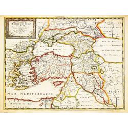
Les Estats de l' Empire des Turqs en Asie.
Nicolas Sanson (1600-67), ' father of the French cartography' and founder of the Sanson firm. Atlas ' Cartes générales de toutes les parties du Monde', 1658-70 and a po...
Date: Paris, Pierre Mariette, c.1650
Selling price: ????
Please login to see price!
Sold in 2008

Mar di India.
This chart from Johannes Janssonius' sea-atlas 'De Water-Weereld' covers the area between the Cape of Good Hope and Japan.It owes its importance to the rendering of the c...
Date: Amsterdam, 1650
Selling price: ????
Please login to see price!
Sold in 2008
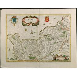
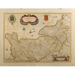
Normandia Ducatus.
Very attractive map of the Normandy in France with the Channel to UK. Various ships and coats of arms are shown.
Date: Amsterdam, 1650
Selling price: ????
Please login to see price!
Sold in 2008
Ducatus Silesiae Glogani Vera Delineatio
Map of Silesia showing the area of Glogow. German text on back.
Date: Amsterdam, 1650
Selling price: ????
Please login to see price!
Sold in 2009
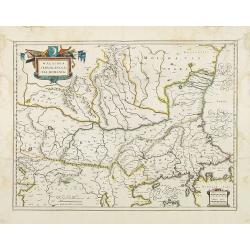
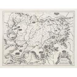
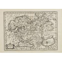
Walachia Servia, Bulgaria, Romania.
The cartographer of this map was Gerard Mercator, but published by the Blaeu family. Map of the region centered on the Lower Danube, Bulgaria, Romania, Serbia and Macedon...
Date: Amsterdam, 1650
Selling price: ????
Please login to see price!
Sold in 2014
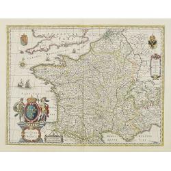
GALLIA. Le royaume de France.
Engraved by the master engraver Josua van den Ende. Attractive map of France, title cartouche at lower left, two royal shields above further shields in the upper corners.
Date: Amsterdam, 1650
Selling price: ????
Please login to see price!
Sold in 2008
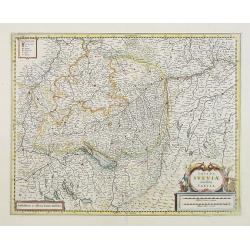
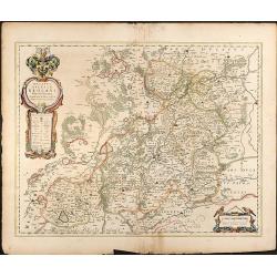
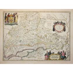
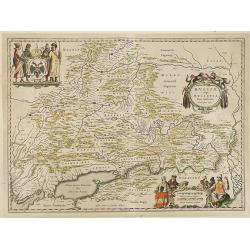
Totius Sueviae novissima tabula.
Beautiful map of Swaben, including Heidelberg, Ulm, Augsburg, Stuttgart, Basel, Zürich, Lucerne, Boden See and Lake Constance.
Date: Amsterdam, 1650
Selling price: ????
Please login to see price!
Sold in 2018
![[Title page] Theatrum orbis Terrarum sive Atlas Novus pars Tertia.](/uploads/cache/25952-250x250.jpg)
[Title page] Theatrum orbis Terrarum sive Atlas Novus pars Tertia.
The frontispiece of the third part of the 'Theatrum', by Johan Blaeu.Decorated with terrestrial and celestial globes and a astronomer and a geographer.
Date: Amsterdam, 1650
Selling price: ????
Please login to see price!
Sold in 2012
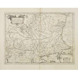
Walachia Servia, Bulgaria, Romania.
The cartographer of this map was Gerard Mercator, but published by the Blaeu family. Map of the region centered on the Lower Danube, Bulgaria, Romania, Serbia and Macedon...
Date: Amsterdam, 1650
Selling price: ????
Please login to see price!
Sold in 2014
Normandia Ducatus
Attractive map of the Normandy in France with the Channel to UK by Jan Jansson. Various ships and coats of arms.
Date: Amsterdam, 1650
Selling price: ????
Please login to see price!
Sold in 2009
Leaf on vellum from a Book of Hours.
Leaf from a Book of Hours manuscript on vellum Italy, 14th Century.Italy 1200s with the drawing c.1650.Written in Latin with marginal decoration and a letter combination ...
Date: Italy 1200s with the drawing c.1650
Selling price: ????
Please login to see price!
Sold in 2009
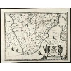
Aethiopia Inferior vel Exterior Monomotapa
Nice engraved map of South Africa from M. Merian based on the Blaeu map. With a beautiful cartouche with turtles and monkeys. With several ships and animals.
Date: Frankfurt, 1650
Selling price: ????
Please login to see price!
Sold in 2009
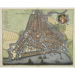
Rotterdam.
Decorative plan of Rotterdam. With extensive shipping on foreground. Very decorative and of the highest standing of engraving.
Date: Frankfurt, 1650
Selling price: ????
Please login to see price!
Sold in 2009
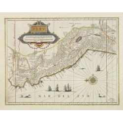
Peru.
Decorated with ships and monsters in the sea. Orientated with east at the top. With the signature of G. Blaeuw lower right corner. Shows the Pacific coast of South Americ...
Date: Amsterdam, 1650
Selling price: ????
Please login to see price!
Sold in 2013
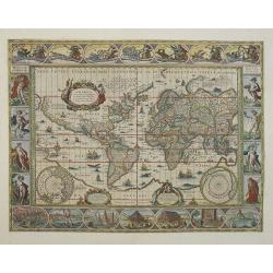
Nova Totius Terrarum Orbis Geographica Ac Hydrographica Tabula..
Much sought after world map by one of the most famous Dutch mapmakers. One of the more well-known "carte à figures" world maps. The paneled borders show, at th...
Date: Amsterdam, c. 1650
Selling price: ????
Please login to see price!
Sold in 2009
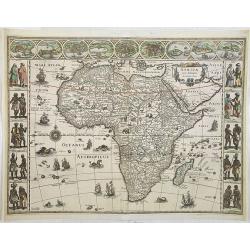
Africae nova descriptio.
A "carte à figures"- map by one of the most prominent publishers of maps. Much of the geographical information is still based on the Ptolemaic maps, with the N...
Date: Amsterdam, 1650
Selling price: ????
Please login to see price!
Sold in 2018
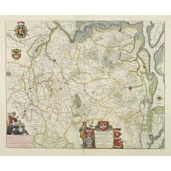
Tertia Pars Brabantiae.
West is at the top. At the lower left the cartouche embellished with male figures with compasses, globe, book and winckel-kruis . At bottom, right of the centre, a beauti...
Date: Amsterdam, 1650
Selling price: ????
Please login to see price!
Sold in 2009
Secunda pars Brabantiae cuis urbus primaria Bruxellae . . .
No text on verso !. At the upper left the title cartouche, decorated with two angels holding the heraldic arms of Brussels, Nijvel and Vilvoorde, next to it that of Braba...
Date: Amsterdam, 1650
Selling price: ????
Please login to see price!
Sold in 2018
India orientalis et insulae adiecentes.
Mathias Merian's fine and decorative reduction of Blaeu's map of South East Asia.
Date: Frankfurt, 1650
Selling price: ????
Please login to see price!
Sold in 2009
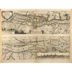
Nobilis Fluvius Albis ... A Ioanne Ianssonio Amstelodami / Emporium Hamburgum
Nice mid 17th century copper engraved map of the course of the Elbe river between Hamburg and the Nordsee by J. Janssonius. With one cartouche and a cityview of Hamburg. ...
Date: Amsterdam, 1650
Selling price: ????
Please login to see price!
Sold in 2009
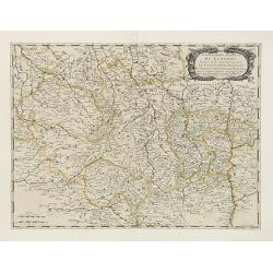
Gouvernement General du Lyonnois . . .
Fine map of central part of France.This edition carries the address of Pierre Mariette: rue St.Jacques a L'Esperance .Nicolas Sanson was to bring about the rise of French...
Date: Paris, 1650
Selling price: ????
Please login to see price!
Sold
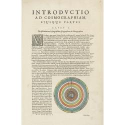
Introductio ad cosmographiam.
On each side a celestial diagram.
Date: Amsterdam, 1650
Selling price: ????
Please login to see price!
Sold in 2009
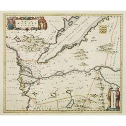
Nova Aegypti Tabula.
Beautiful map of northern Egypt and the Red Sea. With an ornate cartouche and two surveyors supporting the mileage scale. Top right a coat of arms emblazoned with three v...
Date: Amsterdam, 1650
Selling price: ????
Please login to see price!
Sold in 2015
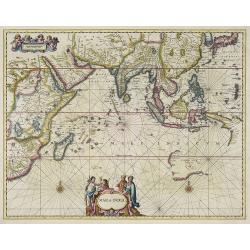
Mar di India.
This chart from Johannes Janssonius' sea-atlas 'De Water-Weereld' (the first European folio sea atlas) covers the area between the Cape of Good Hope and Japan.It owes its...
Date: Amsterdam, 1650
Selling price: ????
Please login to see price!
Sold in 2009
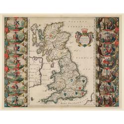
Britannia prout divisa suit temporibus Anglo-Saxonum, præsertim durante illorum Heptarchia.
A fine copy of this famous and decorative map, depicting the ancient kingdoms of Britain, with two side panels. The left-hand border depicts the founders of each of the s...
Date: Amsterdam, 1650
Selling price: ????
Please login to see price!
Sold in 2009
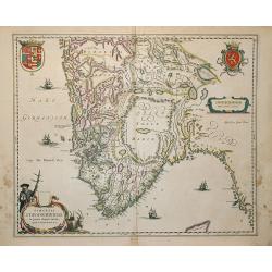
Russiae, vulgo Moscovia, pars Australis.
Centered on Moscow. Prepared by Isaac Massa, a Dutch mapmaker who travelled to Russia, returning to Holland in 1609, bringing with him a large amount of original cartogra...
Date: Amsterdam, 1650
Selling price: ????
Please login to see price!
Sold in 2009
Dioecenis Stavangriensis . . .
Map of Southern Norway with Bergen and Stavanger.
Date: Amsterdam, 1650
Selling price: ????
Please login to see price!
Sold in 2011
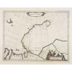
Nova Zemla.
The Dutch were the most persistent searchers after the north-east Passage, whether to the north of Novaya Zemlya (whose west coast is shown in detail) or through what the...
Date: Amsterdam, 1650
Selling price: ????
Please login to see price!
Sold in 2014
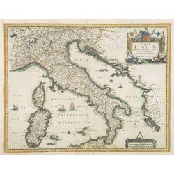
Tabula ITALIAE Corsicae, Sardaniae, et adjacentium Regnorum. . .
An extremely rare map of Italy, including Sicily and Corsica. The map is copied by Cornelis Danckerts II after a map by Henricus Hondius. This map is found only in French...
Date: Paris, 1650
Selling price: ????
Please login to see price!
Sold in 2009
Europa Antiqua cum finitimis Africae & utriusque Asiae regionibus Nicolaus Blancardus Belga, Leidensis, Illustrium Comitatus Zelandiae Ordinum Historicus, ad lucem aevi veteris delineabat.
An uncommon map of Europe prepared by Nicolas Blankaart , extending to the Middle East and the northern tip of Africa, as it was during the time of the Roman Empire. The ...
Date: Amsterdam, 1650
Selling price: ????
Please login to see price!
Sold in 2009
Capitaniae de cirii et Parnambuco.
Rare map of part of the coast of Brazil. From Janssonius' 'Atlas Novus'. Rare. Title in a decorated frame at top right, flanked by allegorical figures, and scale bars in ...
Date: Amsterdam, 1650
Selling price: ????
Please login to see price!
Sold in 2009
Pascaart Vande Zee-Custen van Finmarcken, Laplandt, Ruslant, Nova Zembla en Spitsbergen ... - Tabula Hydrographica Orae Maritimae seu Littorum Finniae, Laplandiae, Russiae, Novae Zemblae et Spitsbergii ...
Chart of the fishing ground of Dutch fishing- and whaling fleets during the 16th, 17th and 18th century, comprising the Barents Sea, northern Norway, Sweden, Finland, nor...
Date: Amsterdam, 1650
Selling price: ????
Please login to see price!
Sold in 2009
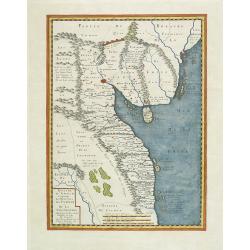
Sinus Gangeticus, Vulgo Golfo De Bengala. Nova descriptio.
Map of the Bay of Bengal, showing Ceylon, the east coast of India, the whole of Burma and the west coast of the Malay peninsula. Figurative cartouche and scale of miles. ...
Date: Amsterdam 1650
Selling price: ????
Please login to see price!
Sold in 2010
Ecs-Miazin. . . Lestrois eglises.
Bird's eye-view of Ecs-Miazin in Armenia. Engraved by I. Peeters.From ' Description des principales villes, havres et Isles du Golfe de Venise du coté Oriental ... des v...
Date: Antwerp, ca 1650
Selling price: ????
Please login to see price!
Sold in 2010
![Teflis. . . [or Tiflis, the Capital of Georgia]](/uploads/cache/27925-250x250.jpg)
Teflis. . . [or Tiflis, the Capital of Georgia]
Early view of Teflis, [or Tiflis] the capital of Georgia and of the other Trans-Caucasian provinces. The print shows the river Kour, and is set in an irregular mountains ...
Date: Antwerp, ca 1650
Selling price: ????
Please login to see price!
Sold in 2009
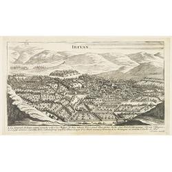
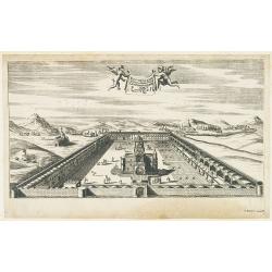
Irivan.
Bird's eye-view of Irivan in Armenia. The print has a lettered key (A-L). Engraved by I. Peeters.From ' Description des principales villes, havres et Isles du Golfe de Ve...
Date: Antwerp, ca 1650
Selling price: ????
Please login to see price!
Sold in 2009
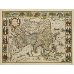
Asia noviter delineata.
From 1633 the members of the Blaeu family were official cartographers to the United East India Company ( V.O.C. ) and, as such, had access to the most up-to-date cartogra...
Date: Amsterdam, 1650
Selling price: ????
Please login to see price!
Sold in 2015
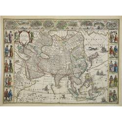
Asia noviter delineata . . .
From 1633 the members of the Blaeu family were official cartographers to the United East India Company and, as such, had access to the most up-to-date cartographic inform...
Date: Amsterdam, c.1650
Selling price: ????
Please login to see price!
Sold in 2017
Russiae vulgo Moscovia pars australis. . .
Centered on Moscow. Prepared by Isaac Massa, a Dutch mapmaker who travelled to Russia, returning to Holland in 1609, bringing with him a large amount of original cartogra...
Date: Amsterdam, 1650
Selling price: ????
Please login to see price!
Sold in 2009
Tabula Russiae.
A re-issue, by Willem Blaeu, of Hessel Gerritsz' rare and influential map of Russia. This fine map was compiled from manuscripts brought back from Russia, by Isaac Massa ...
Date: Amsterdam, 1650
Selling price: ????
Please login to see price!
Sold in 2009
Russiae, vulgo Moscovia, pars Australis.
Prepared by Isaac Massa, a Dutch map-maker who travelled to Russia, returning to Holland in 1609, bringing with him a large amount of original cartographic manuscript mat...
Date: Amsterdam, 1650
Selling price: ????
Please login to see price!
Sold
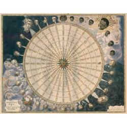
Tabula Anemographica seu Pyxis Nautica.
A most significant anemographic, or wind rose. This unusual chart represents a transitional point in the perception of direction, or to be precise, the transition from th...
Date: Amsterdam, 1650
Selling price: ????
Please login to see price!
Sold in 2010
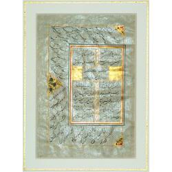
Poems of Hafiz.
Very scarce original manuscript leaf from a CALLIGRAPHIC MANUSCRIPT OF THE DIVAN OF HAFIZ - the collected poems of Muhammed Shamsuddin Hafiz (died ca. 1388 A.D.) - one of...
Date: Persia, ca. 1650
Selling price: ????
Please login to see price!
Sold in 2010
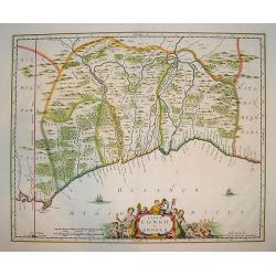
Regna Congo et Angola
A superb delineation of the Congo and Angola as known in the 17th century. Portions of Gabon and Sao Tome are also depicted. Key ports and interior towns are identified a...
Date: Amsterdam, ca. 1650
Selling price: ????
Please login to see price!
Sold in 2010
![[Title page] Rerum Germanicum.](/uploads/cache/27251-250x250.jpg)
[Title page] Rerum Germanicum.
Title page from John. P. Lotichius, Joh. P., Rerum Germanicarum
Date: Frankfurt, W. Hoffmann for M. Merian 1646-1650
Selling price: ????
Please login to see price!
Sold in 2010
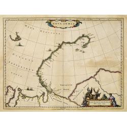
Nova Zemla.
The Dutch were the most persistent searchers after the north-east Passage, whether to the north of Novaya Zemlya (whose west coast is shown in detail) or through what the...
Date: Amsterdam, 1650
Selling price: ????
Please login to see price!
Sold in 2012
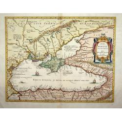
Pontus Euxinus.
Handsome depiction of the environs of the Black Sea in classical times filled with ancient place names and titled also in Greek. The cartography is based on Ortelius' fir...
Date: Amsterdam, 1650
Selling price: ????
Please login to see price!
Sold in 2015
Royaume d'Annan Comprenant Les Royaumes de Tumkin et de la Cocinchine Designé par les Peres de la Compagnie de Iesus
Engraved by Somer. Map of the region from Macao to Laos and Cambodia, centered on Vietnam, Annam and Tonkin region. One of the earliest maps of the region in detail, incl...
Date: Paris, 1650
Selling price: ????
Please login to see price!
Sold in 2011
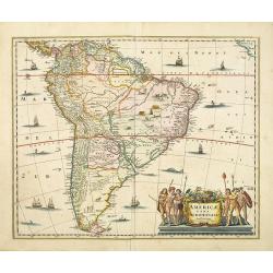
Americae Pars Meridionalis.
Finely engraved map of South America. Decorated with several ships and sea monsters, and a cartouche flanked by engravings of six Indians, netted hammocks and South Ameri...
Date: Amsterdam, 1650
Selling price: ????
Please login to see price!
Sold in 2013