Browse Listings
![No title: [Southern part of Italy]](/uploads/cache/11766-250x250.jpg)
No title: [Southern part of Italy]
Fine map of southern part of Italy and the northern tip of Sicily.This edition carries the date 1648, engraved by AB. De la plaets. With manuscript number in upper right ...
Date: Paris 1648
Selling price: ????
Please login to see price!
Sold
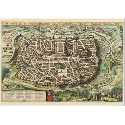
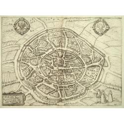
De Heylige en Wytvermaerde Stadt Ierusalem Eerst Genaemt Salem
Very attractive bird's-eye view of Jerusalem, showing the city laid out in blocks with 36 important buildings identified by name through a key index. In the foreground ar...
Date: Amsterdam 1648
Selling price: ????
Please login to see price!
Sold
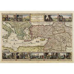
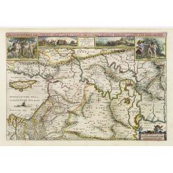
Geographische beschryvinge van de Wandeling der Apostelen ende de Reysen van Pauli.
Finely engraved detailed "carte à figures"- map covering the whole of the eastern Mediterranean. Showing the travels of the apostles after the death of Christ,...
Date: Amsterdam, 1648
Selling price: ????
Please login to see price!
Sold
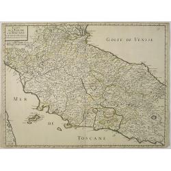
Estats de L'Eglise et de Toscane..
Fine map of Tuscany and the island of Elbe..This edition carries the date 1648. With manuscript number in upper right corner.Nicolas Sanson was to bring about the rise of...
Date: Paris, 1648
Selling price: ????
Please login to see price!
Sold in 2011
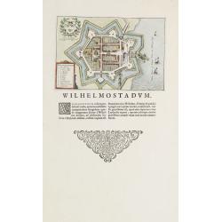
Willemstad.
Plan of the Brabant town "Willemstad" from Blaeus townbooks of the Netherlands. Latin text underneath desribing the foundation of the town by William of Orange...
Date: Amsterdam 1648
Selling price: ????
Please login to see price!
Sold
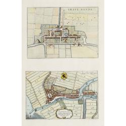
s-Gravensande, Vlaardingen.
Two plans from Blaeus townbooks of the Netherlands. Plan of the town s-Gravensande in the now-a-days province "Zuid Holland". Plan of the town Vlaardingen in...
Date: Amsterdam 1648
Selling price: ????
Please login to see price!
Sold
Lugdunum Batavorum - Leyden in Hollant
Nice hand-colored copper engraving picturing the city of Leiden. The 1648 edition of Guicciardini's famous work Description of the Netherlands was issued by J. Janssonius...
Date: Amsterdam 1648
Selling price: ????
Please login to see price!
Sold
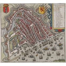
Amstelredam
Nice handcolored copper engraving picturing the city of Amsterdam. From the 1648 edition of Guicciardini's famous work Description of the Netherlands issued by J. Jansson...
Date: Amsterdam 1648
Selling price: ????
Please login to see price!
Sold
Belgicarum Provinciarum Nova Descriptio
Beautifully handcolored copper engraving picturing the Netherlands 17 Provinces. From the 1648 edition of Guicciardini's famous work Description of the Netherlands issued...
Date: Amsterdam 1648
Selling price: ????
Please login to see price!
Sold
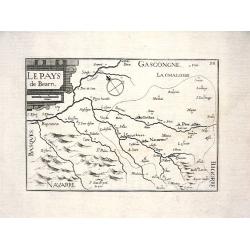
LE PAYS DE BEARN
Nice map from Tassin's desirable and scarce Atlas "Cartes generales de toutes les Provinces de France et d'Espaigne..." published by Berey in 1648. Very detail...
Date: Paris, 1648
Selling price: ????
Please login to see price!
Sold
Virginia.
Detailed miniature map of Virginia, from a German text edition of his Atlas Minor. Engraved by Petrus Kaerius.
Date: Amsterdam (1628) 1648
Selling price: ????
Please login to see price!
Sold
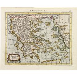
Graecia..
Detailed miniature map of Greece, from a German text edition of his Atlas Minor. The map was published in Janssonius' atlas after the cartographic sources of Laurenberg.
Date: Amsterdam (1628) 1648
Selling price: ????
Please login to see price!
Sold
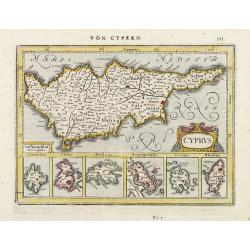
Cyprus.
Detailed miniature map of Cyprus, from a German text edition of his Atlas Minor. Engraved by Petrus Kaerius.
Date: Amsterdam (1628) 1648
Selling price: ????
Please login to see price!
Sold
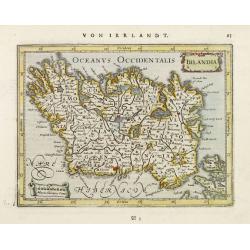
Irlandia.
Detailed miniature map of Ireland, from a German text edition of his Atlas Minor. Engraved by Petrus Kaerius.
Date: Amsterdam (1628) 1648
Selling price: ????
Please login to see price!
Sold
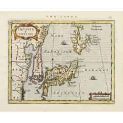
Iaponia et Terra Eso.
Detailed miniature map of Japan with Korea as an island, from a German text edition of his Atlas Minor. Engraved by Petrus Kaerius.
Date: Amsterdam (1628) 1648
Selling price: ????
Please login to see price!
Sold
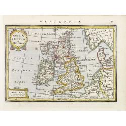
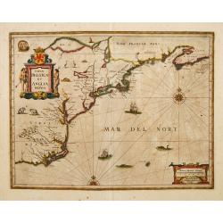
Anglia Scotia et Hibernia.
Detailed miniature map of the British Isles, from a German text edition of his Atlas Minor. Engraved by Petrus Kaerius.
Date: Amsterdam (1628) 1648
Selling price: ????
Please login to see price!
Sold

Russia cum Confiniis.
Detailed miniature map of Russia, from a German text edition of his Atlas Minor. Engraved by Petrus Kaerius.
Date: Amsterdam (1628) 1648
Selling price: ????
Please login to see price!
Sold
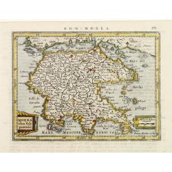
Morea olim Peloponensis.
Detailed miniature map of Morea (Pelopónnisos), from a German text edition of his Atlas Minor. Engraved by Petrus Kaerius.
Date: Amsterdam (1628) 1648
Selling price: ????
Please login to see price!
Sold
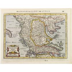
Macedonia Epirus et Achaia.
Detailed miniature map showing Macedonia Epirus and central Greece, from a German text edition of his Atlas Minor. Engraved by Petrus Kaerius.
Date: Amsterdam (1628) 1648
Selling price: ????
Please login to see price!
Sold
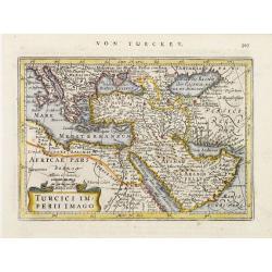
Turcici Imperii Imago.
Detailed miniature map illustrating the Ottoman Empire, the Mediterranean Sea, northern Africa, the Holy Land and Arabia, from a German text edition of his Atlas Minor. E...
Date: Amsterdam (1628) 1648
Selling price: ????
Please login to see price!
Sold
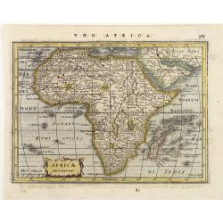
Africae Descriptio.
Detailed miniature map of Africa, from a German text edition of his Atlas Minor. Engraved by A. Goos.
Date: Amsterdam (1628) 1648
Selling price: ????
Please login to see price!
Sold
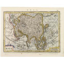
Asia.
Detailed miniature map of Asia, from a German text edition of his Atlas Minor. Engraved by A. Goos.
Date: Amsterdam (1628) 1648
Selling price: ????
Please login to see price!
Sold
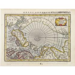
Septentrionalium Terrarum Descript.
Detailed miniature map of the North Pole, from a German text edition of his Atlas Minor. Engraved by Petrus Kaerius.
Date: Amsterdam (1628) 1648
Selling price: ????
Please login to see price!
Sold
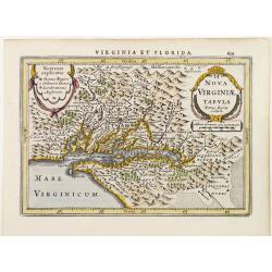
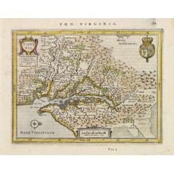
Nova Virginiae Tabula..
Detailed miniature map of Virginia, from a German text edition of his Atlas Minor. Engraved by Petrus Kaerius.
Date: Amsterdam (1628) 1648
Selling price: ????
Please login to see price!
Sold
China.
Detailed miniature map of the eastern part of China, from a German text edition of his Atlas Minor. Engraved by Petrus Kaerius.
Date: Amsterdam (1628) 1648
Selling price: ????
Please login to see price!
Sold
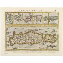
Candia.
Detailed miniature map of Crete, with 6 inset plans of other Greek islands on top. From a German text edition of his Atlas Minor. Engraved by Petrus Kaerius.
Date: Amsterdam (1628) 1648
Selling price: ????
Please login to see price!
Sold
America Meridionalis.
Detailed miniature map of South America, from a German text edition of his Atlas Minor. Engraved by Petrus Kaerius.
Date: Amsterdam (1628) 1648
Selling price: ????
Please login to see price!
Sold
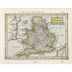
Anglia.
Detailed miniature map of England, from a German text edition of his Atlas Minor. Engraved by Petrus Kaerius.
Date: Amsterdam (1628) 1648
Selling price: ????
Please login to see price!
Sold
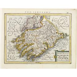
Provincia Momoniae.
Detailed miniature map of the southwestern most tip of Ireland, including the counties of Tipperary, Waterford, Limerick, Cork and Kerry. From a German text edition of hi...
Date: Amsterdam (1628) 1648
Selling price: ????
Please login to see price!
Sold
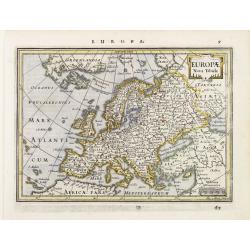
Europae Nova Tabula.
Detailed miniature map of Europe, from a German text edition of his Atlas Minor. Engraved by A. Goos.
Date: Amsterdam (1628) 1648
Selling price: ????
Please login to see price!
Sold
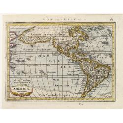
Americae Descriptio.
Detailed miniature map of the Americas, from a German text edition of his Atlas Minor. Engraved by A. Goos.
Date: Amsterdam (1628) 1648
Selling price: ????
Please login to see price!
Sold
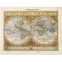
Typus Orbis Terrarum.
Detailed miniature world map, from a German text edition of his Atlas Minor.
Date: Amsterdam (1628) 1648
Selling price: ????
Please login to see price!
Sold
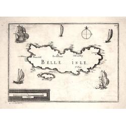
BELLE ISLE
Nice map from Tassin's desirable and scarce Atlas "Cartes generales de toutes les Provinces de France et d'Espaigne..." published by Berey in 1648. Nicely engra...
Date: Paris, 1648
Selling price: ????
Please login to see price!
Sold
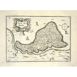
ISLE DE BOUIN
Nice map from Tassin's desirable and scarce Atlas "Cartes generales de toutes les Provinces de France et d'Espaigne..." published by Berey in 1648. Very detaile...
Date: Paris, 1648
Selling price: ????
Please login to see price!
Sold
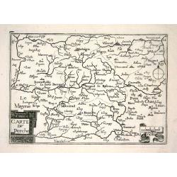
CARTE DU PERCHE
Nice map from Tassin's desirable and scarce Atlas "Cartes generales de toutes les Provinces de France et d'Espaigne..." published by Berey in 1648. Very detaile...
Date: Paris, 1648
Selling price: ????
Please login to see price!
Sold
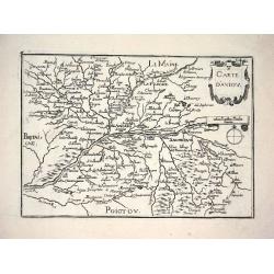
CARTE D'ANIOU
Nice map from Tassin's desirable and scarce Atlas "Cartes generales de toutes les Provinces de France et d'Espaigne..." published by Berey in 1648. Very detaile...
Date: Paris, 1648
Selling price: ????
Please login to see price!
Sold
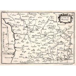
CARTE DE BEAUSSE
Nice map from Tassin's desirable and scarce Atlas "Cartes generales de toutes les Provinces de France et d'Espaigne..." published by Berey in 1648. Very detaile...
Date: Paris, 1648
Selling price: ????
Please login to see price!
Sold
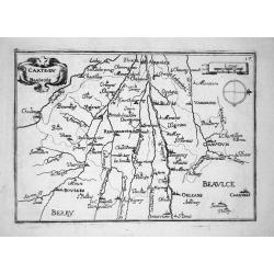
CARTE DU BLAISOIS
Nice map from Tassin's desirable and scarce Atlas "Cartes generales de toutes les Provinces de France et d'Espaigne..." published by Berey in 1648. Very detaile...
Date: Paris, 1648
Selling price: ????
Please login to see price!
Sold
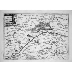
DUCHÉ D'ORLEANS
Nice map from Tassin's desirable and scarce Atlas "Cartes generales de toutes les Provinces de France et d'Espaigne..." published by Berey in 1648. Very detaile...
Date: Paris, 1648
Selling price: ????
Please login to see price!
Sold
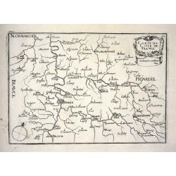
CARTE DE L'ISLE DE FRANCE
Nice map from Tassin's desirable and scarce Atlas "Cartes generales de toutes les Provinces de France et d'Espaigne..." published by Berey in 1648. Very detaile...
Date: Paris, 1648
Selling price: ????
Please login to see price!
Sold
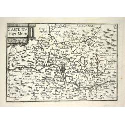
CARTE DU PAYS MESSIN
Nice map from Tassin's desirable and scarce Atlas "Cartes generales de toutes les Provinces de France et d'Espaigne..." published by Berey in 1648. Very detaile...
Date: Paris, 1648
Selling price: ????
Please login to see price!
Sold
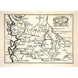
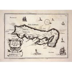
CARTE DU POICTOU
Nice map from Tassin's desirable and scarce Atlas "Cartes generales de toutes les Provinces de France et d'Espaigne..." published by Berey in 1648. Very detaile...
Date: Paris, 1648
Selling price: ????
Please login to see price!
Sold
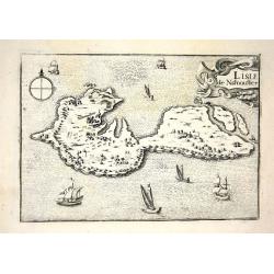
L ISLE DE NARMOUSTIER
Nice map from Tassin's desirable and scarce Atlas "Cartes generales de toutes les Provinces de France et d'Espaigne..." published by Berey in 1648. Very detaile...
Date: Paris, 1648
Selling price: ????
Please login to see price!
Sold
CARTE DE L'ISLE DE RE
Nice map from Tassin's desirable and scarce Atlas "Cartes generales de toutes les Provinces de France et d'Espaigne..." published by Berey in 1648. Very detaile...
Date: Paris, 1648
Selling price: ????
Please login to see price!
Sold
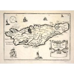
CARTE DE L'ISLE D'OLERON
Nice map from Tassin's desirable and scarce Atlas "Cartes generales de toutes les Provinces de France et d'Espaigne..." published by Berey in 1648. Very detaile...
Date: Paris, 1648
Selling price: ????
Please login to see price!
Sold
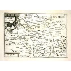
CARTE DU LIMOSIN
Nice map from Tassin's desirable and scarce Atlas "Cartes generales de toutes les Provinces de France et d'Espaigne..." published by Berey in 1648. Very detaile...
Date: Paris, 1648
Selling price: ????
Please login to see price!
Sold
CARTE DU BOURDELOIS & COSTES DE MEDOC &D ARCACHON
Nice map from Tassin's desirable and scarce Atlas "Cartes generales de toutes les Provinces de France et d'Espaigne..." published by Berey in 1648. Very detail...
Date: Paris, 1648
Selling price: ????
Please login to see price!
Sold
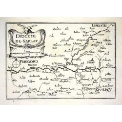
DIOCESE DE SARLAT
Nice map from Tassin's desirable and scarce Atlas "Cartes generales de toutes les Provinces de France et d'Espaigne..." published by Berey in 1648. Very detail...
Date: Paris, 1648
Selling price: ????
Please login to see price!
Sold
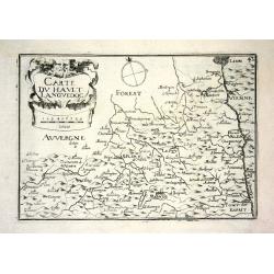
CARTE DU HAULT LANGUEDOC
Nice map from Tassin's desirable and scarce Atlas "Cartes generales de toutes les Provinces de France et d'Espaigne..." published by Berey in 1648. Very detail...
Date: Paris, 1648
Selling price: ????
Please login to see price!
Sold
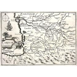
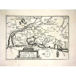
CARTE DE GUYENNE
Nice map from Tassin's desirable and scarce Atlas "Cartes generales de toutes les Provinces de France et d'Espaigne..." published by Berey in 1648. Very detail...
Date: Paris, 1648
Selling price: ????
Please login to see price!
Sold
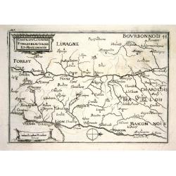
CARTE DU LIONOIS FOREST BEAUIOLOIS ET MASCONNOIS
Nice map from Tassin's desirable and scarce Atlas "Cartes generales de toutes les Provinces de France et d'Espaigne..." published by Berey in 1648. Very detail...
Date: Paris, 1648
Selling price: ????
Please login to see price!
Sold

CARTE DU BAS LAGUEDOC
Nice map from Tassin's desirable and scarce Atlas "Cartes generales de toutes les Provinces de France et d'Espaigne..." published by Berey in 1648. Very detail...
Date: Paris, 1648
Selling price: ????
Please login to see price!
Sold
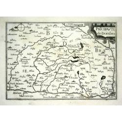
PRICIPAUTE DE DOMBES
Nice map from Tassin's desirable and scarce Atlas "Cartes generales de toutes les Provinces de France et d'Espaigne..." published by Berey in 1648. Very detail...
Date: Paris, 1648
Selling price: ????
Please login to see price!
Sold
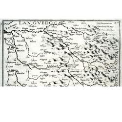
CARTE DE FOIX
Nice map from Tassin's desirable and scarce Atlas "Cartes generales de toutes les Provinces de France et d'Espaigne..." published by Berey in 1648. Very detail...
Date: Paris, 1648
Selling price: ????
Please login to see price!
Sold
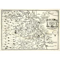
CARTE DE LA PRINCIPAUTE D'ORANGE ET CONTANT DE VENAISSIN
Nice map from Tassin's desirable and scarce Atlas "Cartes generales de toutes les Provinces de France et d'Espaigne..." published by Berey in 1648. Very detail...
Date: Paris, 1648
Selling price: ????
Please login to see price!
Sold
Lutzenbourg
This map in its earliest form by Jacob Van Deventer served as the model for Braun and Hogenberg?s 1581 map of the city. This Guicciardini map, with the engraved plate n...
Date: Amsterdam 1648
Selling price: ????
Please login to see price!
Sold
Geographische beschrijvinge van 'T Beloofde-Landt Canaan..
Fine map of Israel with north oriented to the left. Decorative title cartouche at bottom and an inset picture of the crucifixion in the left top corner. Tiny ships sail i...
Date: Amsterdam, 1648
Selling price: ????
Please login to see price!
Sold
De Gelegentheyt van 't Paradys Ende 't Landt Canaan..
Uncommon issue of this very attractive map, showing the location of Paradise. Two vignettes depict the Temptation of Adam and Eve, and their Expulsion from the Garden of ...
Date: Amsterdam, 1648
Selling price: ????
Please login to see price!
Sold in 2008
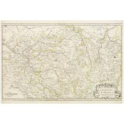
Isle de France / Champagne / Lorraine.
Showing the regions around Paris, Metz and Troyes. R. Cordier.
Date: Paris, 1648
Selling price: ????
Please login to see price!
Sold
Aquisgranum, vulgo Aich Per antiqua Imperii urbs, etc.
Nice bird?s-eye view of the city of Aachen. With coats of arms of German Empire and the city. South is on top of the view. Copper etching nr. 100 in the 1648 Dutch Jansso...
Date: Amsterdam, 1648
Selling price: ????
Please login to see price!
Sold in 2008
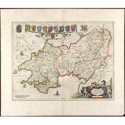
Penbrochia Comitatus et Comitatus Caermaridunum
Attractive map of the country of Pembrokeshire in UK by J. Blaeu. From a Dutch edition of "Atlas Maior" in beautiful color. br>With 13 coats of arms, one car...
Date: Amsterdam, 1648
Selling price: ????
Please login to see price!
Sold in 2008
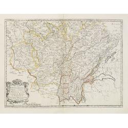
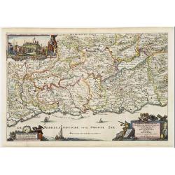
Les Deux Bourgognes Duché et comté la Bresse &c. la Souveraineté de Dombes, le Nivernois &c..
Fine map of Burgundy.This edition carries the date 1648.Nicolas Sanson was to bring about the rise of French cartography, although the fierce competition of the Dutch wou...
Date: Paris, 1648
Selling price: ????
Please login to see price!
Sold
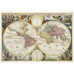
Orbis terrarum typus de integro in plurimis emendatus..
A scarce Dutch Bible map attributed by Shirley to either Cornelis Danckerts or Jacob Savry. The map itself features California as an island but with the retention of the ...
Date: Amsterdam, 1648
Selling price: ????
Please login to see price!
Sold in 2009
![[Astrakan to Parskylan]](/uploads/cache/28797-250x250.jpg)
[Astrakan to Parskylan]
Showing the region of the Cremea, from Astrakan to Parskylan.
Date: 1648
Selling price: ????
Please login to see price!
Sold in 2010
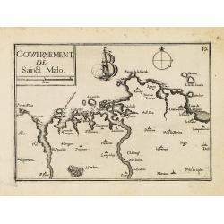
Gowernement de Saint Malo.
Nice map centered on St. Malo from Tassin's desirable and scarce Atlas "Cartes generales de toutes les Provinces de France et d'Espaigne..." published by Berey ...
Date: Paris, Bery, 1648
Selling price: ????
Please login to see price!
Sold in 2010
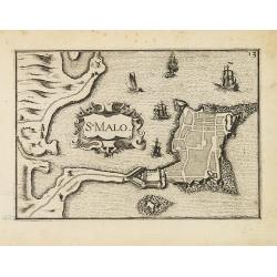
St Malo.
Nice town-plan of St. Malo from Tassin's desirable and scarce Atlas "Cartes generales de toutes les Provinces de France et d'Espaigne..." published by Berey in ...
Date: Paris, Berey, 1648
Selling price: ????
Please login to see price!
Sold in 2010
Gravia obsessa et expugnata armis ordinum Belgicae..
A military map showing Grave and the surrounding area with fortifications. With a decorative title cartouche, a blank cartouche with two figures and a military scene vign...
Date: Amsterdam 1649
Selling price: ????
Please login to see price!
Sold
![[Title page] Nieuwen ATLAS ofte Weereldt-Beschrijvinghe/..](/uploads/cache/02235-250x250.jpg)
[Title page] Nieuwen ATLAS ofte Weereldt-Beschrijvinghe/..
The title panel is flanked to the left by a man in armour and to the right a woman with the coat of arms of Holland.At the top two lions holding a cloth with 17 coats-of-...
Date: Amsterdam, 1647/1649
Selling price: ????
Please login to see price!
Sold in 2011
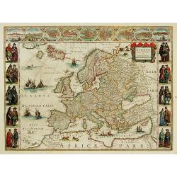
Europa recens descripta.
On either side columns depicting the manner of dress in the major countries of Europe, surmounted by nine city views and plans. For European mapmakers their own continent...
Date: Amsterdam 1649
Selling price: ????
Please login to see price!
Sold
Nova Belgica et Anglia Nova.
A second state. Derived from De Laet's map of 1630, which was important as the first appearance on a printed map of 'Manhattes' (Manhattan), 'N.Amsterdam' (New York, foun...
Date: Amsterdam 1649
Selling price: ????
Please login to see price!
Sold
![[Title page] Archontologia Cosmica..](/uploads/cache/17475-250x250.jpg)
[Title page] Archontologia Cosmica..
Very fine title page by one of Germany most important publishers. From Archontologia Cosmica.. by L.Gotfried.Putti and 4 women representing the four continents, accompani...
Date: Frankfurt 1649
Selling price: ????
Please login to see price!
Sold
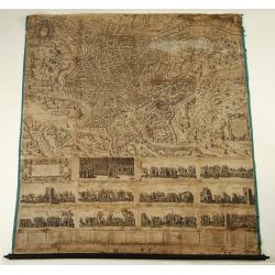
Urbis Romae Sciographia ex Antiquus Monumentis Accuratiss. Delineata.
Large wall map of the most famous plan of Ancient Rome. The plate in 8 sheets is engraved by and first published by Stephanus Du Perac in 1574: re-published by Villamena ...
Date: Rome, after 1649
Selling price: ????
Please login to see price!
Sold
![[ Title page] Nouvel & Grand Theatre des villes de tous les Pay-Bas. Premier tome.](/uploads/cache/16548-250x250.jpg)
[ Title page] Nouvel & Grand Theatre des villes de tous les Pay-Bas. Premier tome.
The title panel is flanked to the left by a man in armor and to the right a woman with the coat of arms of Holland.At the top two lions holding a cloth with 17 coats-of-a...
Date: Amsterdam 1649
Selling price: ????
Please login to see price!
Sold
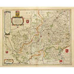
Silesia Inferior.
Johannes Janssonius, the great rival of Willem Blaeu, was the son-in-law of Jodocus Hondius. Together with Jodocus' son Hendrick, he continued to publish the successive e...
Date: Amsterdam, 1649
Selling price: ????
Please login to see price!
Sold in 2009
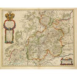
Ducatus Silesiae Glogani Vera Delineatio. Iona Sculteta Sprotta.
Johannes Janssonius, the great rival of Willem Blaeu, was the son-in-law of Jodocus Hondius. Together with Jodocus' son Hendrick, he continued to publish the successive e...
Date: Amsterdam, 1649
Selling price: ????
Please login to see price!
Sold in 2009
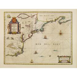
Nova Belgica et Anglia Nova.
A second state. Derived from De Laet's map of 1630, which was important as the first appearance on a printed map of 'Manhattes' (Manhattan), 'N.Amsterdam' (New York, foun...
Date: Amsterdam 1649
Selling price: ????
Please login to see price!
Sold
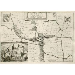
Schagen
Fine map of the town of Schagen with inserted a nice engraving of the Castle of Schagen.Copper engraving from Joan Blaeu's Toneel der Steden (townbook) 1649.Dutch text on...
Date: Amsterdam 1649
Selling price: ????
Please login to see price!
Sold
Breda Obsessa Et Expugnata a Celsissimo Friderico Henrico.
Fine map of Breda and environs to show the siege of the town by Frederik Hendrik, Prince of Orange, in 1637. Lower left a decorative cartouche with a dedication and coats...
Date: Amsterdam, 1649
Selling price: ????
Please login to see price!
Sold in 2013
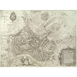
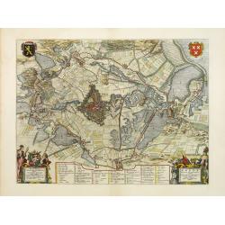
Amisfurtum. (Amersfoort)
A bird's-eye view of the town.
Date: Amsterdam 1649
Selling price: ????
Please login to see price!
Sold
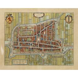
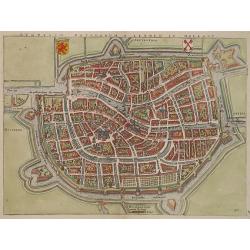
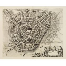
Delfi Batavorum vernacule Delft.
Detailed plan of the city Delft from Joan Blaeu's town book of the Netherlands, first published one year after the peace of Munster and the Spanish acknowledgement of the...
Date: Amsterdam, 1649
Selling price: ????
Please login to see price!
Sold in 2010