Browse Listings
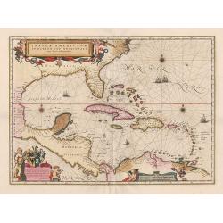
Insulae Americanae in Oceanus Septentrionali, ...
General map of the West Indies extending from Virginia to the mouth of the Orinoco, and destined to be copied in various shapes by many other publishers.
Date: Amsterdam, 1647
Selling price: ????
Please login to see price!
Sold in 2014
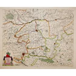
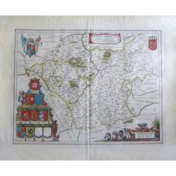
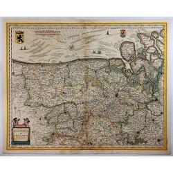
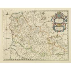
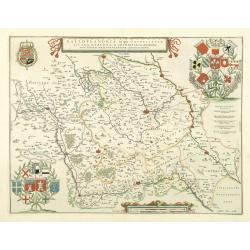
Flandria Gallica Continens Castellanias Insulensem Duacensem Orchianensem Civitatem Dominiumq: Tornacense.
This map of a part of Walloon province of Belgium in the centre is Lille, In 1667, Louis XIV of France successfully laid siege to Lille, resulting in it becoming French i...
Date: Amsterdam, 1647
Selling price: ????
Please login to see price!
Sold in 2020
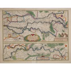
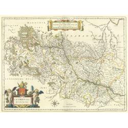
Tractus Rheni et Mosae totusq Vahalis.
Shows that part of the central Netherlands where the three great rivers flow to within but a few kilometers of each below Wesel. The scale allows most of the larger towns...
Date: Amsterdam, 1647
Selling price: ????
Please login to see price!
Sold in 2016
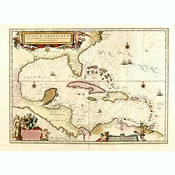
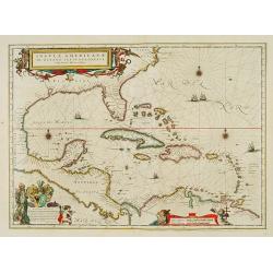
Insulae Americanae in Oceanus Septentrionali cum Terris..
General map of the West Indies extending from Virginia to the mouth of the Orinoco, and destined to be copied in various shapes by many other publishers.Title cartouche t...
Date: Amsterdam, 1647
Selling price: ????
Please login to see price!
Sold in 2015
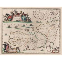
Lalandiae et Falstriae Accurata Descriptio.
Map of some regions of Denmark, from Sive Theatrum Orbis Terrarum. Text in Latin on the back.
Date: Amsterdam, 1647
Selling price: ????
Please login to see price!
Sold in 2014
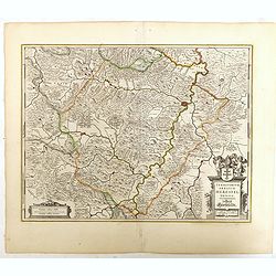
Territorium Abbatiae Herefeldensis - 't Stift Hirszfeldt.
Detailed map centered on Hirschfelt. Title cartouche embellished with two cherubs.
Date: Amsterdam, 1647
Selling price: ????
Please login to see price!
Sold in 2018
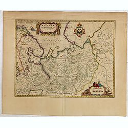
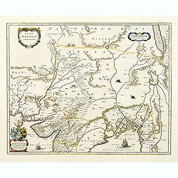
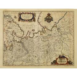
Russiae vulgo Moscovia dictae, Partes Septentrionalis..
In the north the Murmansk Sea. Including the western coast of Nova Zembla. Title cartouche and two cartouches, the bottom right one showing two hunters, bears, stags etc....
Date: Amsterdam, 1647
Selling price: ????
Please login to see price!
Sold in 2015
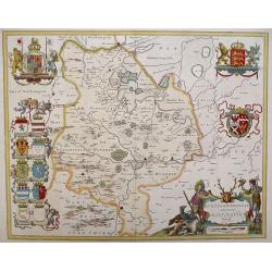
'LEICESTRENSIS COMITATUS' Leicestershire
An attractive, finely engraved and hand colored copperplate 17th century map of Leicestershire. German text edition with two Royal crests, fine cartouches for title and s...
Date: Amsterdam, 1647
Selling price: ????
Please login to see price!
Sold in 2017
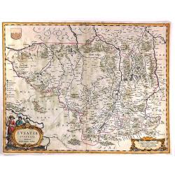
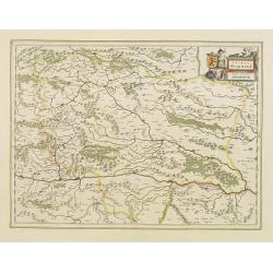
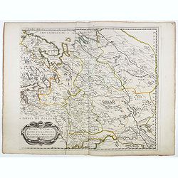
Lusatia Superior.
An attractive map of the region of present-day southwestern Poland, at the border with Germany and the Czech Republic. Old city names include Prybus, Lieba, Gorlitz, Dres...
Date: Amsterdam, 1647
Selling price: ????
Please login to see price!
Sold in 2018
![[Title page]. Novus Atlas...Engelland, Schotland and Irland.](/uploads/cache/81736-250x250.jpg)
[Title page]. Novus Atlas...Engelland, Schotland and Irland.
The decorative title page from Jansson's atlas of England, Scotland and Ireland. Set in an architectural style with figures representing the invaders and settlers of Brit...
Date: Amsterdam, 1647
Selling price: ????
Please login to see price!
Sold in 2018
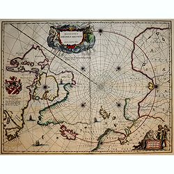
Regiones Sub Polo Arctico.
A fine Blaeu version of the Janssonius map of 1637. It depicts rhumb lines radiating from the North Pole. A large title cartouche, with two figures and numerous wind head...
Date: Amsterdam, 1647
Selling price: ????
Please login to see price!
Sold in 2017
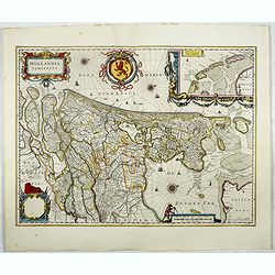
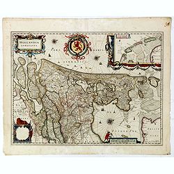
Hollandia Comitatus.
Orientated west to the top of the sheet, this represents the County of Holland in the classical orientation for seventeenth century maps, with Amsterdam at the centre. Th...
Date: Amsterdam, 1647
Selling price: ????
Please login to see price!
Sold in 2017
Zutphania Comitatus.
Detailed map of the area "Zutphania" includings the cities of Zutphen, Arnhem, Emmerich, and Deventer. South to the top. More about maps by Willem Blaeu. [+]
Date: Amsterdam, 1647
Selling price: ????
Please login to see price!
Sold in 2017
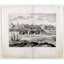
Nisen-Navgorod.
An early of Nisen-Navgorod, on the Volga river. From the rare first edition "Offt begehrte Beschreibung der newen orientalischen Rejse, so durch Gelegenheit einer H...
Date: Schleßwig, Zur Glocken, 1647
Selling price: ????
Please login to see price!
Sold

Kremelin.
An early town-view of Kremlin in Moscow. From the rare first edition "Offt begehrte Beschreibung der newen orientalischen Rejse, so durch Gelegenheit einer Holsteini...
Date: Schleßwig, Zur Glocken, 1647
Selling price: ????
Please login to see price!
Sold in 2021
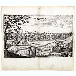
Weliki: Novogord order Gros: Navgard.
An early of Veliky Novgorod in west Russia on the Volkhov River. From the rare first edition "Offt begehrte Beschreibung der newen orientalischen Rejse, so durch Ge...
Date: Schleßwig, Zur Glocken, 1647
Selling price: ????
Please login to see price!
Sold in 2017
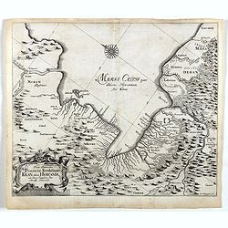
Vera Delineatio Prouinciae Fertilissimae . . .
Detailed map of the Southern Caspian Sea, showing the area north of Tehran. From the rare first edition "Offt begehrte Beschreibung der newen orientalischen Rejse, s...
Date: Schleßwig, Zur Glocken, 1647
Selling price: ????
Please login to see price!
Sold in 2021
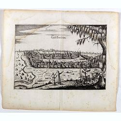
Casan Tartarorum.
An early of Kazan, Russia. From the rare first edition "Offt begehrte Beschreibung der newen orientalischen Rejse, so durch Gelegenheit einer Holsteinischen Legatio...
Date: Schleßwig, Zur Glocken, 1647
Selling price: ????
Please login to see price!
Sold in 2022
Flandria et Zeelandia Comitatus.
A decorative, large map including Flanders and Zeeland. The map was originally engraved, in 1641, for Sanderus 'Flandria Illustrata', and was used at different times in B...
Date: Amsterdam, 1647
Selling price: ????
Please login to see price!
Sold in 2018
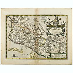
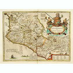
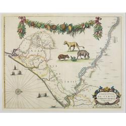
Nova Hispania et Nova Galicia.
Based on Ortelius's map of 1579 which became the basis for many of the seventeenth century maps of the area. A lovely copy of this decorative map.
Date: Amsterdam, 1647
Selling price: ????
Please login to see price!
Sold in 2018
Hollandia Comitatus.
Orientated west to the top of the sheet, this represents the County of Holland in the classical orientation for seventeenth century maps, with Amsterdam at the center. Th...
Date: Amsterdam, 1647
Selling price: ????
Please login to see price!
Sold in 2019
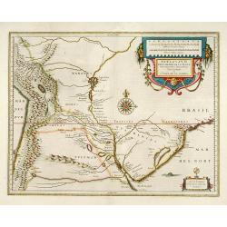
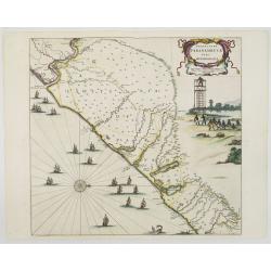
Paraguayo prov. de Rio de La Plata cum regionibus..
A beautiful map of Paraguay, Uruguay and northern Argentina.
Date: Amsterdam, 1647
Selling price: ????
Please login to see price!
Sold in 2013

Title page from
Attractive title page of Blaeu's "Le Theatre du Monde", volume II, part II. Surmounted with the Spanish Royal Arms; in recesses in the architectural façade are...
Date: Amsterdam, 1647
Selling price: ????
Please login to see price!
Sold
Nova Hispania et Nova Galicia.
Based on Ortelius's map of 1579 which became the basis for many of the seventeenth century maps of the area. Despite the implications in the title, the map does not cover...
Date: Amsterdam, 1647
Selling price: ????
Please login to see price!
Sold in 2011
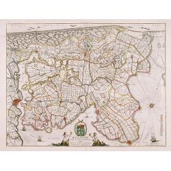
Hollandiae pars septentrionalis, Vulgo Westvriesland en 't Noorder Quartier.
Based on the work of B.F.van Berckenrode, this fine map, orientated west to the top of the sheet, includes Kennemerland and Hollands Noorderkwartier and is a reasonably u...
Date: Amsterdam 1647
Selling price: ????
Please login to see price!
Sold
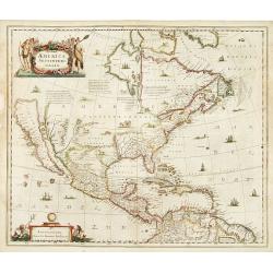
America Septentrionalis.
Showing California as an island, and above, the north west of the continent is left blank except for two legends explaining the discoveries to that date. The Hudson Bay i...
Date: Amsterdam 1647
Selling price: ????
Please login to see price!
Sold
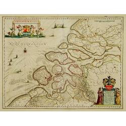
Zeelandia Comitatus.
Map of Zealand with title and coat of arms of Zeeland at top left. At bottom right a dedication in the cartouche by W.Blaeu to Simon van Beaumont. The map shows Zeeland a...
Date: Amsterdam 1647
Selling price: ????
Please login to see price!
Sold
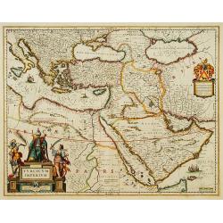
Turcicum Imperium.
A very handsome map with a particularly fine cartouche showing the Turkish Sultan on his throne and allegorical figures at either side brandishing weapons. At right is a ...
Date: Amsterdam 1647
Selling price: ????
Please login to see price!
Sold
Territorium Abbatiae Heresfeldensis. 't Stift Hirszfeldt
A large seventeenth century hand colored map of the territory of Hirschfeld, (Hersfeld/Hesse) Germany. Shows Bad Hersfeld vicinity. From Niewe Atlas. 23.25" x 19.75&...
Date: Amsterdam, ca.1647
Selling price: ????
Please login to see price!
Sold
Insulae Americanae in Oceanus Septentrionali cum Terris..
General map of the West Indies extending from Virginia to the mouth of the Orinoco, and destined to be copied in various shapes by many other publishers. Title cartouche ...
Date: Amsterdam 1647
Selling price: ????
Please login to see price!
Sold
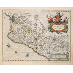
Nova Hispania et Nova Galicia.
Map of old Mexico based on Ortelius's map of 1579 which became the basis for many of the seventeenth century maps of the area. A lovely copy of this decorative map.
Date: Amsterdam, 1647
Selling price: ????
Please login to see price!
Sold in 2022
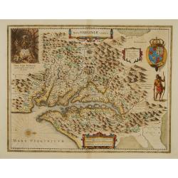
Nova Virginiae Tabula.
The map is based on the first state of Smith's map, 1612, and is slightly larger and more expertly engraved.The map is, in part, famous for its depiction, upper left, of ...
Date: Amsterdam 1647
Selling price: ????
Please login to see price!
Sold
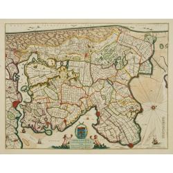
Hollandiae pars septentrionalis, Vulgo Westvriesland..
Based on the work of B.F.van Berckenrode, this fine map, orientated west to the top of the sheet, includes Kennemerland and Hollands Noorderkwartier and is a reasonably u...
Date: Amsterdam 1647
Selling price: ????
Please login to see price!
Sold
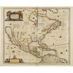
America Septentrionalis.
Showing California as an island, and above, the north west of the continent is left blank except for two legends explaining the discoveries to that date. The Hudson Bay i...
Date: Amsterdam 1647
Selling price: ????
Please login to see price!
Sold
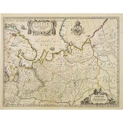
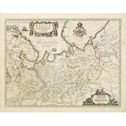
Russiae vulgo Moscovia dictae, Partes Septentrionalis..
In the north the Murmansk Sea. Including the western coast of Nova Zembla. Title cartouche and two cartouches, the bottom right one showing two hunters, bears, stags etc....
Date: Amsterdam 1647
Selling price: ????
Please login to see price!
Sold
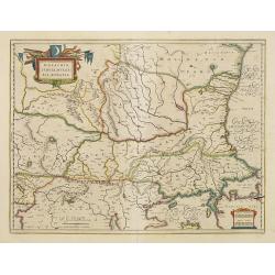
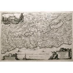
Walachia, Servia, Bulgaria, Romania.
Striking map of the region centered on the Lower Danube, Bulgaria, Romania, Serbia and Macedonia. Includes decorative cartouche, coat of arms, etc. Latin text on verso.Th...
Date: Amsterdam 1647
Selling price: ????
Please login to see price!
Sold
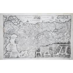
Stiria - Steyermarck.
Covering eastern part of Austria, Styria and Carinthia, centered on the town of Graz.
Date: Amsterdam, 1647
Selling price: ????
Please login to see price!
Sold in 2017
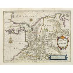
Terra Firma et Novum regnum Granatense et Propayan.
Fine copy, with wide margins of this handsome map of the Isthmus of Panama and northwestern South America including most of present day Columbia and part of Venezuela. Te...
Date: Amsterdam, 1647
Selling price: ????
Please login to see price!
Sold in 2008
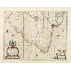
Brasilia.
Fine copy of this map by Krystof Arciszewski, a Polish general who worked for the Dutch West Indian Company. The map perpetuates various myths including the Parime Lago ,...
Date: Amsterdam 1647
Selling price: ????
Please login to see price!
Sold
Magni Mogolis Imperium.
An attractive map of northern India and Central Asia bounded by Pakistan, Afganistan and Bangladesh and extening inland up the Ganges and Indus Rivers to Tartary and the ...
Date: Amsterdam, 1647
Selling price: ????
Please login to see price!
Sold
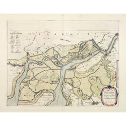
Tabula Castelli ad Sandflitam, ..Bergas ad Zomam et Antverpi
East is at the top. The map pictures the complex military situation that had developed after the Dutch blockade of Antwerp. All entrenchment's and fortresses marked by a ...
Date: Amsterdam 1647
Selling price: ????
Please login to see price!
Sold in 2008
Clivia Ducatus et Ravestein Dominium
A very decorative map showing the towns of Nijmegen, Venlo, Moers and Emmerich.
Date: Amsterdam, 1647
Selling price: ????
Please login to see price!
Sold
![[Title page] Nouvel Atlas Ou Theatre du Monde..](/uploads/cache/22827-250x250.jpg)
[Title page] Nouvel Atlas Ou Theatre du Monde..
A very attractive title page from Nouvel Atlas Ou Theatre du Monde. Representant LES PAYS BAS, ou dixsept Provinces de la Basse Allemagne. Seconde Partie Du Second Tome. ...
Date: Amsterdam 1647
Selling price: ????
Please login to see price!
Sold
Walachia, Servia, Bulgaria, Romania.
Striking map of the region centered on the Lower Danube, Bulgaria, Romania, Serbia and Macedonia. Includes decorative cartouche, coat of arms, etc. Latin text on verso.Th...
Date: Amsterdam 1647
Selling price: ????
Please login to see price!
Sold
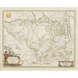
Lusatia Superior.
Attractive map of the region straddling present-day southwestern Poland, Saxony and the Czech Republic.Old city names including Lieba, Gorlitz, Dresden, Pirnaw, and Prybu...
Date: Amsterdam, 1647
Selling price: ????
Please login to see price!
Sold in 2011
Praefecturae Paranambucae pars Meridionalis.
EXTREMELY RARE issue, printed for C.Barlaeus, and before included in the Blaeu Atlas Major. Extends from the Rio San Francisco to the Rio Gujaraigacu.This map is one the ...
Date: Amsterdam, 1647
Selling price: ????
Please login to see price!
Sold in 2008
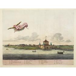
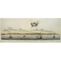
Boa vista.
EXTREMELY RARE issue, printed for C.Barlaeus.This plate is one the first views of Brazil based on Dutch rather than Portuguese interest. The drawing was made by Frans Pos...
Date: Amsterdam, 1647
Selling price: ????
Please login to see price!
Sold in 2008
Artesia Comitatus. Artois.
Very decorative map of north-western part of France.As Willem Blaeu died in 1638 most of his maps are actually published by his son Joan. This maps carries his (engraved)...
Date: Amsterdam, 1647
Selling price: ????
Please login to see price!
Sold in 2011
Loanda S.Pauli.
Attractive coastal view of the island of Luanda (Angola). The name means "flat land" as the island has no mountains and is comprised only of sand deposited by t...
Date: Amsterdam, 1647
Selling price: ????
Please login to see price!
Sold in 2008
Praefecturae de ciriii vel seregippe delrey cum Itapuama.
EXTREMELY RARE issue, printed for C.Barlaeus, and before included in the atlas. This map is one the first maps of Brazil based on Dutch rather than Portuguese interest. T...
Date: Amsterdam, 1647
Selling price: ????
Please login to see price!
Sold in 2008
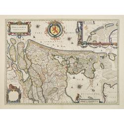
Hollandia Comitatus.
Orientated west to the top of the sheet, this represents the County of Holland in the classical orientation for seventeenth century maps, with Amsterdam at the centre. Th...
Date: Amsterdam, 1647
Selling price: ????
Please login to see price!
Sold in 2009
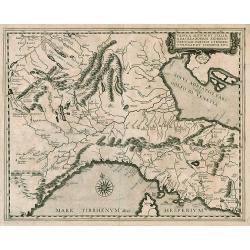
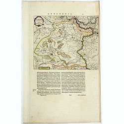
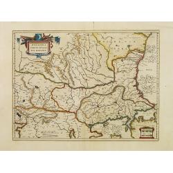
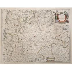
Tabula Alpium et Italiae a Basilea Romam...
Rare map from a book published by Hermannus Crombach. North Italy & Alps.
Date: Cologne, 1647
Selling price: ????
Please login to see price!
Sold in 2009
Galloflandria, in qua Castellaniae Lilana, duacena, et orchiesia, cum dependentibus ; necnon Tornacum, et Tornacesium / Auctore Martino Doué Gallo-Flandro
A very decorative map of the Gallic Flanders or Walloon Flanders comprising the Castellanies of Lille and Douai and the Tournaisis.
Date: Amsterdam, 1647
Selling price: ????
Please login to see price!
Sold in 2021
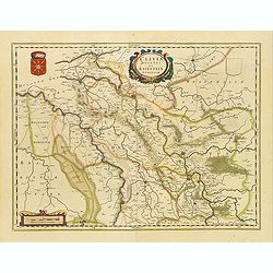
Leodiensis dioecesis.
West to the top. Fine map including the Dutch and Belgium provinces Limburg and the Belgium province of Namen and Ardennes. German text on verso.
Date: Amsterdam, 1647
Selling price: ????
Please login to see price!
Sold in 2018
Russiae vulgo Moscovia dictae, Partes Septentrionalis. . .
In the north the Murmansk Sea. Including the western coast of Nova Zembla. Title cartouche and two cartouches, the bottom right one showing two hunters, bears, stags etc....
Date: Amsterdam, 1647
Selling price: ????
Please login to see price!
Sold in 2010
Russiae vulgo Moscovia dictae, Partes Septentrionalis. . .
In the north the Murmansk Sea. Including the western coast of Nova Zembla. Title cartouche and two cartouches, the bottom right one showing two hunters, bears, stags etc....
Date: Amsterdam, 1647
Selling price: ????
Please login to see price!
Sold in 2013
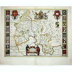
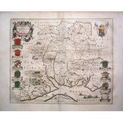
Oxonium Comitatus, Vulgo Oxford shire.
Double-page map of the county of Oxford on the Thames River. This English county map is highly decorative with figurative title cartouche of two scholars. Royal arms and ...
Date: Amsterdam, 1647
Selling price: ????
Please login to see price!
Sold in 2012
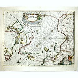
Regiones Sub Polo Arctico.
North pole region. It depicts rhumb lines radiating from the North Pole. A large title cartouche, with two figures and numerous wind heads, conveniently hides the unknown...
Date: Amsterdam, 1647
Selling price: ????
Please login to see price!
Sold in 2013
VOLGA RIVER. -Accurata delineatio Nobilissmi toti Europae Fluminis Wolgae olim RHA dictae per Adamum Olearium.
Rare First Edition of The First Great Map of the Volga River. Nice example of Olearius' map of the Volga River, first issued in 1647 and engraved by Christian Rothgiesser...
Date: Schleswig, 1647
Selling price: ????
Please login to see price!
Sold in 2021
![[Lot of a portrait of Johan Maurits Count of Nassau-Siegen and title page both from Rerum per octennium in Brasilia. ]](/uploads/cache/48309-250x250.jpg)
[Lot of a portrait of Johan Maurits Count of Nassau-Siegen and title page both from Rerum per octennium in Brasilia. ]
Title page and portrait taken from the rare work about Brasil "Rerum per octennium in Brasilia et alibi nuper gestarum, sub præfectura illustrissimi comitis J. Maur...
Date: Amsterdam, 1647
Selling price: ????
Please login to see price!
Sold in 2022
![[ Lot of 3 items of the Holy Land] Perigrinatie ofte Veertich-jarige Reyse, Der Kinderen Israels.](/uploads/cache/86347-250x250.jpg)
[ Lot of 3 items of the Holy Land] Perigrinatie ofte Veertich-jarige Reyse, Der Kinderen Israels.
The rare ' Wandering Children Israel ' map by Jacob Savry from a Dutch bible. Right bottom 3 vignettes with the Camp Israel, Vessels of the Temple and a priest. Above the...
Date: Amsterdam, 1647
Selling price: ????
Please login to see price!
Sold in 2023
Stato Di Milano.
Engraved map with Dutch text on verso, Covers the area of Italy from the lakes in the north to Regiano to the south centered on Milan.
Date: Amsterdam, 1648
Selling price: ????
Please login to see price!
Sold in 2016
HUNTINGDONENSIS COMITATUS, HUNTINGTON SHIRE
A highly attractive and finely copper plate engraved 17th century map This example bears French text to the verso and the usual excellent quality coloring.
Date: Amsterdam, 1648
Selling price: ????
Please login to see price!
Sold in 2013
Hantonia Sive Southantonensis Comitatus Vulgo Hantshire
A very attractive Blaeu map of Hampshire. The map is embellished with royal coat of arms, and also of earls of Winchester and Southampton. Latin text on verso.
Date: Amsterdam, 1648
Selling price: ????
Please login to see price!
Sold in 2013
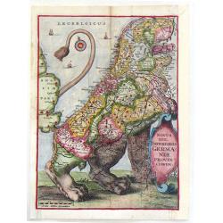
Novus XVII, Inferioris Germaniae Provenciarum
This hand-colored, copper engraving is one of the most interesting decorative works of cartography. It shows The Netherlands and Belgium in the shape of a lion and is cal...
Date: Rome, 1648
Selling price: ????
Please login to see price!
Sold in 2013
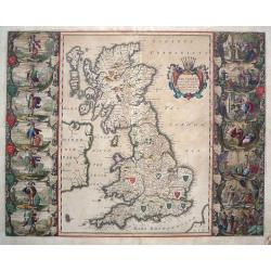
Britannia Prout Divisa Suit Temporibus Anglo-Saxonum.
An impressive and decorative historical map of the British Isles with the seven Anglo-Saxon kingdoms, Northumbria, Mercia, East Anglia, Essex, Kent, Sussex and Wessex. Ea...
Date: Amsterdam, 1648
Selling price: ????
Please login to see price!
Sold in 2014
Geographische Beschryvinge van t'Beloofde-Landt Canaan, door Wandelt van onsen Heere ende Salichmaecker Iesu Christo nessens syne Apostelen van nieus gecorigeert ende seer verbetert door Iacob Savery Ao 1648
Fine Bible map of the Holy Land by or after Visscher. Highly detailed with numerous place names, rivers, mountains, and regions. The sea is filled with fishing boats, th...
Date: Amsterdam, 1648
Selling price: ????
Please login to see price!
Sold in 2014
Perigrinatie ofte Veertich-jarige Reyse der Kinderen Israels.
Dutch so-called "Staten-bibles," published between 1637 and c. 1760, contained five maps: The World, "Paradise," The Peregrinations, The Promised Land...
Date: Dordrecht, 1648
Selling price: ????
Please login to see price!
Sold in 2019
Estats du Czar ou Grand Duc de la Russie Blanche ou Moscovie.
Eastern portion of Sanson's two-sheet map of Russia and White Russia, extending from the Gulf of Finland to the Caspian Sea and Central Asia. A nice example.Engraved by A...
Date: Paris, 1648
Selling price: ????
Please login to see price!
Sold in 2017
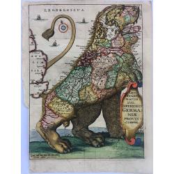
Leo Belgicus (Novus XVII Inferioris Germaniae Provinciarum)
A striking example of 'Leo Belgicus' (the Low Countries in the shape of a lion), which illustrated Strada's book on the 80 year war between Spain and the Low Countries.&q...
Date: Antwerp, ca. 1648
Selling price: ????
Please login to see price!
Sold in 2020
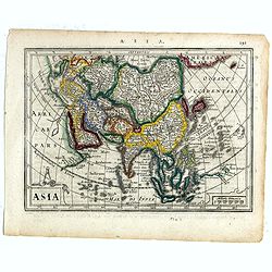
Asia.
Charming map of Asia. The west coast of New Guinea is exaggerated. Engraved by Abraham Goos, with his signature. From the Mercator Hondius “Atlas Minor” published in ...
Date: Amsterdam, 1648
Selling price: ????
Please login to see price!
Sold in 2017
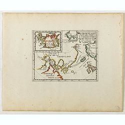
Groenland et les Nouvelles Terres Descouvertes Vers Le Septentrion.
Rare map of the Arctic regions, focusing on the recent discoveries in the region. Inset map of Iceland (62x84mm.) in upper left corner. The map was based on the informati...
Date: Paris, ca. 1648
Selling price: ????
Please login to see price!
Sold in 2019
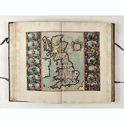
Vierde Stuck der Aerdrycks-Beschryving, welck vervat Engelandt, i.e. Theatrum Orbis Terrarum. vol 4, England & Wales.
>An outstanding example of Joannes Blaeu's "Vierde Stuck der Aerdrycks-Beschryving, welck vervat Engelandt, i.e. Theatrum Orbis Terrarum": being volume 4, En...
Date: Amsterdam, 1648
Selling price: ????
Please login to see price!
Sold
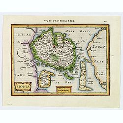
Fionia.
A pretty map of Fionia (Funen) from the Mercator Hondius “Atlas Minor” published in Amsterdam in 1648 (with Janssonius) with German text on verso. In 1607, Jodocus Ho...
Date: Amsterdam, ca 1648
Selling price: ????
Please login to see price!
Sold in 2019
![Les Deux Bourgognes, Duché et Comté, la Bresse & la Souveraineté de Dombes, le Nivernois, &c. [Proof state ]](/uploads/cache/44009-250x250.jpg)
Les Deux Bourgognes, Duché et Comté, la Bresse & la Souveraineté de Dombes, le Nivernois, &c. [Proof state ]
Rare proof state of Sanson' map "Les Deux Bourgognes, Duché et Comté, la Bresse & la Souveraineté de Dombes, le Nivernois, &c", printed without title...
Date: Paris, c. 1648
Selling price: ????
Please login to see price!
Sold in 2021
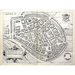
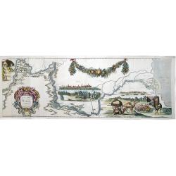
Arnhemium Gelriae in Ripa Rheni Opp.
A bird's eye view plan of Arnhem, Gelderland. After Lodovico Guicciardini by J. Janssonius. Filled with buildings and details. With the coat of arms and a title cartouche...
Date: Amsterdam, 1648
Selling price: ????
Please login to see price!
Sold in 2019
Estats du Czar ou Grand Duc de la Russie Blanche ou Moscovie.
Eastern portion of Sanson's two-sheet map of Russia and White Russia, extending from the Gulf of Finland to to the Caspian Sea and Central Asia. A nice example.Engraved b...
Date: Paris, 1648
Selling price: ????
Please login to see price!
Sold
Estats du Czar ou Grand Duc de la Russie Blanche ou Moscovie.
Eastern portion of Sanson's two-sheet map of Russia and White Russia, extending from the Gulf of Finland to the Caspian Sea and Central Asia. A nice example.Engraved by A...
Date: Paris, 1648
Selling price: ????
Please login to see price!
Sold
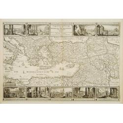
Geographische beschryvinge van de Wandeling der apostelen ende reysen van Pauli.
Finely engraved detailed map covering the whole of the eastern Mediterranean. Showing the travels of the apostles after the death of Christ, with episodes from the life o...
Date: Amsterdam 1648
Selling price: ????
Please login to see price!
Sold

Africae nova descriptio.
Much of the geographical information is still based on the Ptolemaic maps, with the Nile shown with its source in the Lakes Zaire and Zaflan. Also included are various ot...
Date: Amsterdam 1648
Selling price: ????
Please login to see price!
Sold