Browse Listings in Europe > Russia / Baltic / Black Sea region
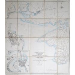
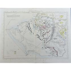
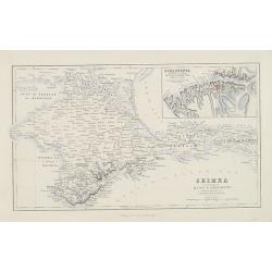
Stanford's Map of the Roads &c. Between Odessa, Nikolaief, Perekop, Simfieropol, and Sebastopol.
Folding map of south-eastern Ukraine, focusing on the region between Odessa and just east of Balaklava. Large inset maps of Odessa and Nikolayev to left edge. The whole d...
Date: London, 1855
Selling price: ????
Please login to see price!
Sold in 2012
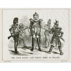
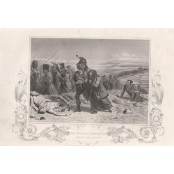
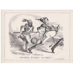
A set of 10 humorous prints from the Russian Empire's war with French and British Empire's.
Ten humoorous prints with the following titles: - Another Russian Victory!!! July 8th 1854. - The Russian Frankenstein and His Monster July 15th 1854. - The Real ...
Date: London 1854-1855
Selling price: ????
Please login to see price!
Sold in 2012
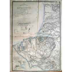
The Environs of Sevastopol with the Batteries & Approaches.
Large lithographed plan of the Siege of Sevastopol. Shows the surroundings of the city in great topographical detail, and all the troop locations. Also indicates roads, t...
Date: London, c1855
Selling price: ????
Please login to see price!
Sold in 2012
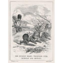
A set of 9 humorous prints from the Russian Empire's war with French and British Empire's.
Nine humorous prints with the following titles: - The Queen visiting the Imbeciles of the Crimea,1855- Cruel Treatment of Russian Prisoners in England,1854.- Bursting of ...
Date: London, 1854-1855
Selling price: ????
Please login to see price!
Sold in 2012
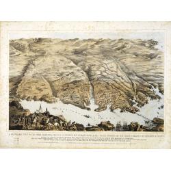
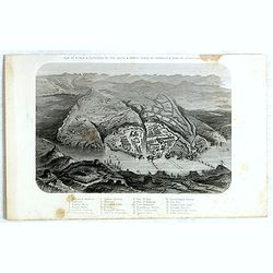
A panoramic view of the town, harbour, forts & defences of Sebastopol & the siege works of the allied armies of England & France. . .
A panoramic town-plan of the town, harbour, forts and defenses of Sevastopol in Ukraine.Chromolithographed and designed by Thomas Packer, and published by Stannard and Di...
Date: London, 1855
Selling price: ????
Please login to see price!
Sold in 2013
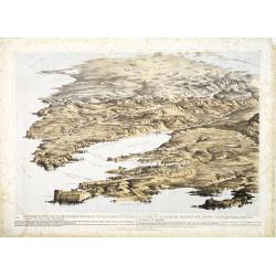
![A Panoramic View of the Position now occupied by the Allied Armies before Sebastopol [. . .] sketched by command of the Emperor Louis Napoleon by an eminent officer of the French Imperial Engineers](/uploads/cache/33753-250x250.jpg)
A Panoramic View of the Position now occupied by the Allied Armies before Sebastopol [. . .] sketched by command of the Emperor Louis Napoleon by an eminent officer of the French Imperial Engineers
A panoramic view of the position occupied by the Allied Armies before Sevastopol in Ukraine.Chromolithographed and designed by Thomas Parker, and published by Read & ...
Date: London, 1855
Selling price: ????
Please login to see price!
Sold in 2013
Panoramic view of the Present Extended Position of the Allied Armies of England, France, Turkey and Sardinia. - Panorama de la position presente des armées alliées, Anglaise, Française, Turque et Sarde. . .
Panoramic view of the position of the Allied Armies of England, France, Turkey and Sardinia at the south side of Sevastopol in Ukraine.Chromolithographed and designed by ...
Date: London, 1855
Selling price: ????
Please login to see price!
Sold in 2013
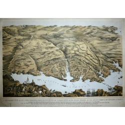
A Panoramic View of the Town, Harbour, Forts & Defences of Sebastopol & The Siege Works of The Allied Armies of England & France.
Printed & Published April 18th 1855 by Stannard & Dixon 7, Poland St London. A large panoramic plan of the town, harbour, forts and defenses of Sevastopol in Ukra...
Date: London, 1855
Selling price: ????
Please login to see price!
Sold in 2014
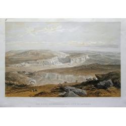
The ruins of Inkermann and city of caverns.
A spectacular view of the area of Inkerman in the Ukraine, now under Russian control (Crimean peninsula). Original colored lithograph by Day & Son. Published May 22nd...
Date: London, 1855
Selling price: ????
Please login to see price!
Sold in 2015
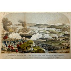
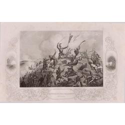
Vigorous Attack of the Allies on the Russian Ambuscades In front of the Mamelon and Malakoff Towers, May 9, 1855.
A highly detailed lithograph showing the battle to silence the Malakoff Towers. In the distance a view of Sebastopol looking towards the Dockyard Harbour... The Malakoff ...
Date: London, 1855
Selling price: ????
Please login to see price!
Sold in 2017
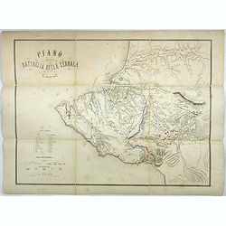
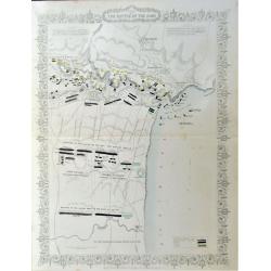
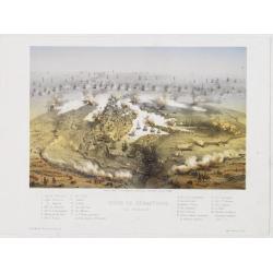
Plano della battaglia della Cernaia.
Large lithographed map showing the Battle of the Chernaya. Decorative title with numbered key (1-17) and a color key indicating the French, English, Italian, Turkish and ...
Date: Milan, 1855
Selling price: ????
Please login to see price!
Sold in 2017
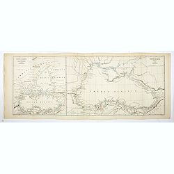
Ponti Euxini Periplus secundum Arrianum.
Two ancient maps on one sheet showing the Black Sea and Ukraine, prepared by Karl Wilhelm Ludwig Muller (1813-1894) and published in "Geographi Graeci Minores"....
Date: Paris, Ambrosio Firmin Didot, 1855
Selling price: ????
Please login to see price!
Sold in 2017
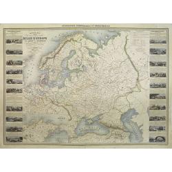
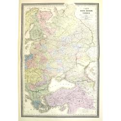
Russia in Europe showing the Territorial Acquisitions since the time of Peter the Great.
"Russia in Europe showing the Territorial Acquisitions since the time of Peter the Great" This map shows the acquisitions from Turkey, Sweden, Poland and Persia...
Date: London, 1855
Selling price: ????
Please login to see price!
Sold in 2019
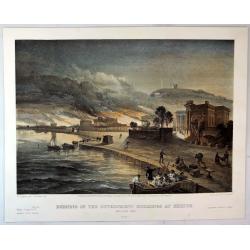
Burning of the Government buildings at Kertch.
A fine hand colored lithograph from "THE SEAT OF WAR IN THE EAST". By the illustrator William Simpson (1823-1899). Published in London in 1855 by Paul and Domin...
Date: London, 1855
Selling price: ????
Please login to see price!
Sold in 2018
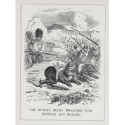
A set of 15 humorous prints from the Russian Empire's war with the French and British Empire's.
This set of 15 are from 1847 - 1856. Mostly engraved by Joseph Swain. Joseph Swain was one of the most important woodblock engravers. Punch was responsible for the word s...
Date: London 1847 - 1856
Selling price: ????
Please login to see price!
Sold in 2015
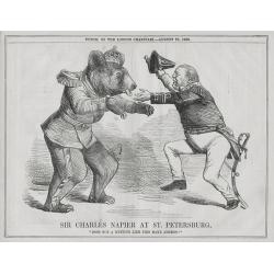
A set of 15 humorous prints from the Russian Empire's war with the French and British Empire's.
This set of 15 are from 1846 - 1856. Mostly engraved by Joseph Swain. Joseph Swain was one of the most important woodblock engravers. Punch was responsible for the word s...
Date: London 1846 - 1856
Selling price: ????
Please login to see price!
Sold in 2015

A set of 16 humorous woodblock prints from the Russian Empire's war with the French and British Empire's.
This set of 16 are from 1853 - 1856, mostly engraved by Joseph Swain. Joseph Swain was one of the most important woodblock engravers.Punch was responsible for the word se...
Date: London, 1853 - 1856
Selling price: ????
Please login to see price!
Sold in 2015
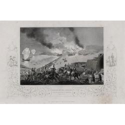
Four lithographic scenes from the Crimean War.
Four lithographic scenes from the Crimean War, based on sketches by William Simpson, which were published in London by Paul and Dominic Colnaghi & Co.- The Charge of ...
Date: London, 1856
Selling price: ????
Please login to see price!
Sold in 2017
A set of 8 maps from The Crimea War.
A set of 8 maps from The Crimea War 1856. By W. & A.K Johnston, published by W & R Chambers London 1856. The titles: 'Portion of The Crimea Forming Chief Scene of...
Date: London, 1856
Selling price: ????
Please login to see price!
Sold in 2016

A set of 16 humorous woodblock prints from the Russian Empire's war with the French and British Empire's.1853 - 1857.
This set of 16 are from This set of 16 are from 1853 - 1857, mostly engraved by Joseph Swain. Joseph Swain was one of the most important woodblock engravers. Punch was re...
Date: London, 1853 -1857
Selling price: ????
Please login to see price!
Sold in 2015
(Crimea) A complete set of 26 engravings depicting The Crimea war, the Battles between the Russian Empire ...
A complete set of 26 engravings depicting The Crimea war, the Battles between the Russian Empire and several European powers for influence over territories of the declini...
Date: London, 1858
Selling price: ????
Please login to see price!
Sold in 2015
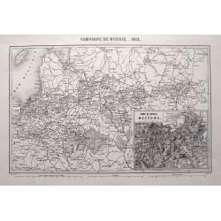
CAMPAGNE DE RUSSIE 1812.
Highly detailed map showing the area from Poland and the Baltics to Moscow, including the cities of Kiev, Minsk, Smolensk, Riga, and many more. An inset map shows the are...
Date: Paris, 1858
Selling price: ????
Please login to see price!
Sold in 2015
A complete set of 30 engravings depicting The Crimea war, the Battles between the Russian Empire and several European powers for influence over territories of the declining Ottoman Empire, Nicholas I. Emperor of Russia and the Military Leaders of the Euro
A complete set of 28 engravings depicting The Crimea war, the Battles between the Russian Empire and several European powers for influence over territories of the declini...
Date: London, 1858
Selling price: ????
Please login to see price!
Sold in 2016
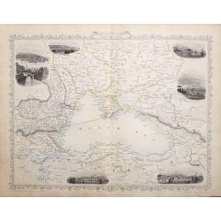
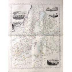
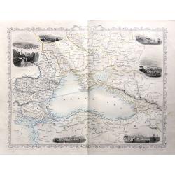
Black Sea.
A highly detailed and decorative map with six vignette illustrations. One of the John Tallis maps published around the time of the Crimea War by The London Printing and P...
Date: London, 1858
Selling price: ????
Please login to see price!
Sold in 2016
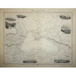
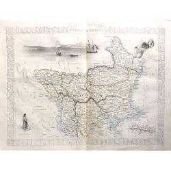
Black Sea
A highly detailed and decorative map of the Black Sea and surrounding areas. The map is enhanced by vignette illustrations of Sebastopol, Varna, Odessa, Sinope, Silistra...
Date: London, 1858
Selling price: ????
Please login to see price!
Sold in 2017
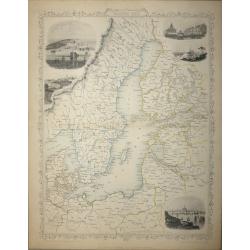
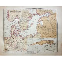
Baltic Sea - John Tallis
A highly detailed and decorative map of the Baltic Sea and surrounding countries with five vignette illustrations.One of the John Tallis maps published around the time of...
Date: London, 1858
Selling price: ????
Please login to see price!
Sold in 2015
(Crimea) A set of 24 engravings depicting The Crimea war, the Battles between the Russian Empire and several European powers for influence over territories of the declining Ottoman Empire.
A set of 24 engravings depicting The Crimea war, the Battles between the Russian Empire and several European powers for influence over territories of the declining Ottoma...
Date: London, 1858
Selling price: ????
Please login to see price!
Sold in 2015
A set of 18 engravings ‘The Crimea War' the Battles between the Russian Empire and the European powers for influence over territories of the declining Ottoman Empire, Nicholas I. Emperor of Russia and the Military Leaders of the European powers.
A collection of 18 steel engravings, depicting The Crimea war, those Battles between the Russian Empire and several European powers for influence over territories of the ...
Date: London, 1858
Selling price: ????
Please login to see price!
Sold in 2016
Baltic Sea - John Tallis
A highly detailed and decorative map of the Baltic Sea and surrounding countries with five vignette illustrations.One of the John Tallis maps published around the time of...
Date: London, 1858
Selling price: ????
Please login to see price!
Sold in 2016
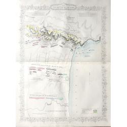
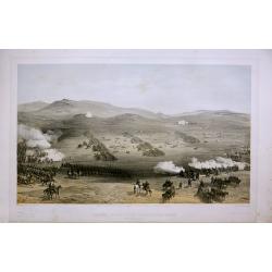
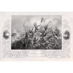
Plan of The Battle of The Alma
A highly detailed battle plan depicting the 'Battle of the Alma River in Crimea', one of the first battles of the Crimean War.The Battle of the Alma was fought September ...
Date: London, 1858
Selling price: ????
Please login to see price!
Sold in 2016
Black Sea
A map of the Black Sea and the surrounding lands, including Turkey, Russia, Georgia, Azerbaijan, Bulgaria, Crimea and Armenia, with six decorative vignettes views of Seba...
Date: London, 1858
Selling price: ????
Please login to see price!
Sold in 2018
'Turkey in Europe'
A highly decorative and detailed mid-19th century map of 'Turkey in Europe' The Balkans: northern Greece, Macedonia, Bulgaria, Albania, Serbia, Bosnia-Herzogovina, southe...
Date: London, 1858
Selling price: ????
Please login to see price!
Sold in 2016
‘The Crimea War' 18 engravings depicting the Battles between the Russian Empire and the European powers for influence over territories of the declining Ottoman Empire, and the Military Leaders of the European powers.
‘The Crimea War.’ 18 engravings depicting the Battles between the Russian Empire and the European powers for influence over territories of the declining Ottoman Empir...
Date: London, 1858
Selling price: ????
Please login to see price!
Sold in 2016
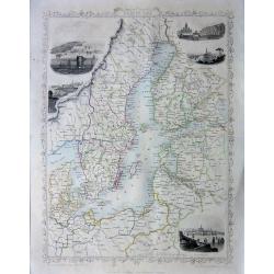
Baltic Sea
A highly detailed and decorative map of the Baltic Sea and surrounding countries with five vignette illustrations.One of the John Tallis maps published around the time of...
Date: London, 1858
Selling price: ????
Please login to see price!
Sold in 2016
20 engravings depicting The Crimea war, the Battles between the Russian Empire and several European powers for influence over territories of the declining Ottoman Empire, Nicholas I. Emperor of Russia and Military Leaders of the European Powers.
An interesting set of 20 engravings depicting The Crimea war, the Battles between the Russian Empire and several European powers for influence over territories of the dec...
Date: London, 1858
Selling price: ????
Please login to see price!
Sold in 2017
A SET OF 20 engravings depicting The Crimea war, the Battles between the Russian Empire and several European powers for influence over territories of the declining Ottoman Empire, Nicholas I. Emperor of Russia and Military Leaders of the European Powers
An interesting set of 20 engravings depicting The Crimea war, the Battles between the Russian Empire and several European powers for influence over territories of the dec...
Date: London, London Printing & Publishing Company, 1858
Selling price: ????
Please login to see price!
Sold in 2020
Provincie ecclesiastiche di Leopoli e Fogaras ed Altre Diocesi di Rito Greco (Tav LXXV)
This large-format Romania map is finely engraved and beautifully colored and was prepared by Girolamo Petri, a lawyer who served as a senior official within the Vatican�...
Date: Rome, 1858
Selling price: ????
Please login to see price!
Sold in 2025
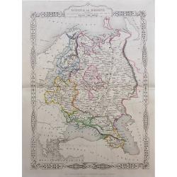
Russie Europeenne et Asiatique.
A large detailed map of the entirety of the Russian Empire, as it was under Czar Alexander II in the middle of the nineteenth century. Also shown as part of the map are F...
Date: Paris, 1858
Selling price: ????
Please login to see price!
Sold in 2020
Plan of the Battle of the Alma.
A detailed steel engraved map of the Battle of Alma The map includes a hand colored key as to the positions of the English, French, Turks, and Russians. Inscription: Draw...
Date: London, 1858
Selling price: ????
Please login to see price!
Sold in 2020
Siege of Sebastopol.
A detailed steel engraved map of Sebastopol. The map includes a hand colored key as to the positions of the English, French, Turks, Russians, and Sardinians. Dates and po...
Date: London, 1858
Selling price: ????
Please login to see price!
Sold in 2020
![[A panoramic view of Saint Isaakievskiy Sobor and the Monument to Nicholas I on St Isaac's Square ]. N° 22.](/uploads/cache/27222-250x250.jpg)
[A panoramic view of Saint Isaakievskiy Sobor and the Monument to Nicholas I on St Isaac's Square ]. N° 22.
Uncommon print of Saint Isaakievskiy Sobor and the Monument to Nicholas I on St Isaac's Square.Saint Isaac's Cathedral or Isaakievskiy Sobor in Saint Petersburg, Russia i...
Date: Paris, 1859
Selling price: ????
Please login to see price!
Sold in 2009

A set of 16 humorous woodblock prints from the Russian Empire's war with the French and British Empire's.
This set of 16 plates are from 1854 - 1859, mostly engraved by Joseph Swain. Joseph Swain was one of the most important woodblock engravers. Punch was responsible for the...
Date: London, 1854 -1859
Selling price: ????
Please login to see price!
Sold in 2015
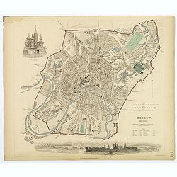
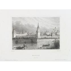
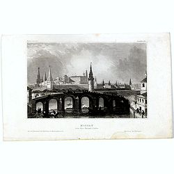
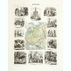
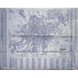
Moscow.
A nice decorative town plan of the city of Moscow, showing the ancient city behind fortified walls, with a pair of lovely vignettes 'Church of the Assumption in the Kreml...
Date: London, 1859
Selling price: ????
Please login to see price!
Sold in 2020
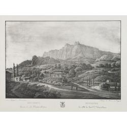
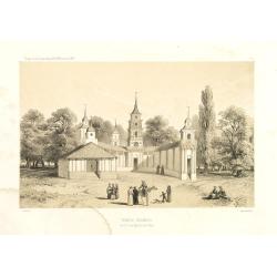
Mischore la ville du General L. Narischkine.
Lithography of the Mischore countryside. Lithographed by Braun and Bigatti.Text in Russian and French.
Date: c. 1860
Selling price: ????
Please login to see price!
Sold in 2014
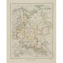
Europish Rusland.
Uncommon map of Russia. Lithography by J.H. van Weijer, published in Atlas der geheele Aarde [?] in 24 kaarten. With colored key to processions.
Date: Groningen, ca. 1860
Selling price: ????
Please login to see price!
Sold in 2008
Nouvelle carte illustrée des Etats du Nord et de l'Europe donnant la Russie d'Europe La Suède et le Danemark . . .
A most decorative mid 19th century map, in left and right part 20 vignettes giving a wealth of statistic and commercial information. Besides Russia's provinces the neighb...
Date: Paris, ca. 1860
Selling price: ????
Please login to see price!
Sold in 2009
Moscou. (Russie).
View of Moscow. Drawn and engraved by Lechard.
Date: Paris, Mutrel, ca. 1860
Selling price: ????
Please login to see price!
Sold in 2009
MER NOIRE Sébastopol. 61.
Beautiful and rare lithography of the port of Sevastopol at the Black Sea the Crimea peninsula. Extensive shipping in the harbor. With a numbered key (1-22) in lower part...
Date: Paris, Lemercier, c.1860
Selling price: ????
Please login to see price!
Sold in 2010
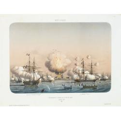
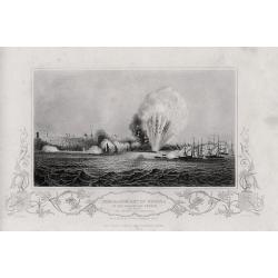
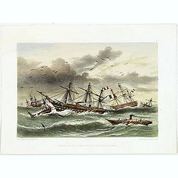
MER D'AZOF. Bombardement d'arabat par la flotille alliée 25 Mai 1855.
Beautiful and rare lithography of two French boats, "Le Lucifer" and "La Miranda" during the siege of Arabat in 1855.
Date: Paris, Lemercier, c.1860
Selling price: ????
Please login to see price!
Sold in 2010
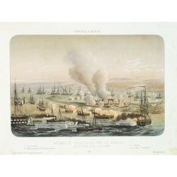
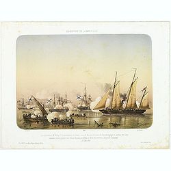
AFFAIRES D'ORIENT Attaque et reddition du fort de Kilburn par les flottes alliées, 17 octobre 1855.
Beautiful engraving of the siege of Kilburn on 17 October 1855 by the French navy. After a design Louis by Le Breton. including a numbered key (1-4) in the lower part.Lou...
Date: Paris, Lemercier, c.1860
Selling price: ????
Please login to see price!
Sold in 2010
Crimea according to Huot & Demidoff.
Detailed map probably from, A Gazetteer of the World, Or Dictionary of Geographical Knowledge, Compiled from the Most Recent Authorities, and Forming a Complete Body of M...
Date: Edinburg, London, Fullarton, 1860
Selling price: ????
Please login to see price!
Sold in 2010
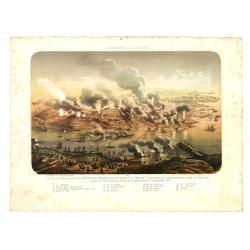
Sébastopol vue du Nord. - Les divisions françaises aux ordres des généraux Bosquet et Mac Mahon prennent d'assaut la tour Malakoff. . , (le 8 septembre 1855). Crimée (Ukraine)
Lithography of the siege of Sebastopol on 8 September 1855 who resulted in a French victory under General MacMahon. In one of the Crimean War defining moments, the French...
Date: Paris, Lemercier, c.1860
Selling price: ????
Please login to see price!
Sold in 2010
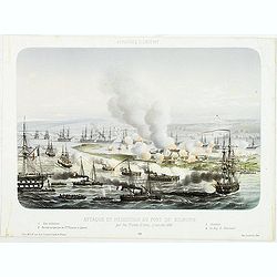
AFFAIRES D'ORIENT Attaque et reddition du fort de Kilburn par les flottes alliées, 17 octobre 1855.
Beautiful lithography of the siege of Kilburn on 17 October 1855 by the French navy. After a design Louis by Le Breton. including a numbered key (1-4) in lower part.Louis...
Date: Paris, Lemercier, c.1860
Selling price: ????
Please login to see price!
Sold in 2014
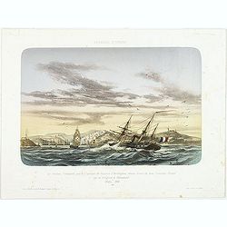
AFFAIRES D'ORIENT Le Vauban, Commandé par le Captaine de Vaisseau d'Herbinghem, chasse devant lui deux Croiseurs Russes qui se réfugient à Sévastopol. Mars 1854.
Beautiful lithography of the French steamer "Le Vaunan", commanded by Captain de Poucques d'Herbingheme, chasing two Russian Vessels seeking safe-harbour in Sev...
Date: Paris, Lemercier, c.1860
Selling price: ????
Please login to see price!
Sold in 2013
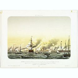
EXPEDITION DE LA MER D'AZOF Le Lieutenant M.Killop Captain la canonniére le Snake, sous le feu des batteries de Kertch. . . 22 Mai 1855.
Beautiful lithography of an encounter which took place on 22 May 1855 between Lieutenant M'Killop, who was the commander of a gunboat, the Snake, with 3 Russian vessels, ...
Date: Paris, Lemercier, c.1860
Selling price: ????
Please login to see price!
Sold in 2014
MER BALTIQUE Juillet 1855 Les Vasseaux le Blenheim et l'Exmouth aux ordres du C.A. Seymour protegent de leur feux une division de cannonieres qui sous la volées des Forts Russes vont amarriner des prises q l'entree du port de Narva.
Beautiful lithography of the vessels Blenheim and l'Exmouth bombarding the forts at the entrance of the river and town of Narva in July 1855.After a design Louis by Le Br...
Date: Paris, Lemercier, c.1860
Selling price: ????
Please login to see price!
Sold in 2014
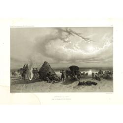
Ouragan du 14 dans la Mere Noir vis à vis la Baie de Kamiesh.
Beautiful lithography of French ships in Kamiesch Bay in the Black Sea near Sebastopol on the Crimean coast. During the siege of Sebastopol in 1854 during the Crimean War...
Date: Paris, Lemercier, c.1860
Selling price: ????
Please login to see price!
Sold in 2014

Le descartes devant Sébastopol.
Beautiful lithography of the French steamer Le Descartes offshore of Sevastopol.After a design by Louis Le Breton (1818 Douarnenez - 1866 Paris). Louis Le Breton was a Fr...
Date: Paris, Langlumé, c.1860
Selling price: ????
Please login to see price!
Sold in 2014
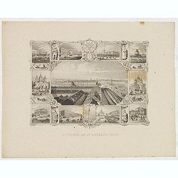
Souvenir de St. Petersbourg.
Panoramic view of St. Petersburg surrounded with ten little views of different places and monuments.
Date: France, ca. 1860
Selling price: ????
Please login to see price!
Sold in 2013
Europa und der nördliche Theil von Asien.
Somewhat later but very finely drawn map of Europe and the rendering of Russia. Including "Berings Srasse" and tip of North America with "Aleutische Inseln...
Date: Germany, ca. 1860
Selling price: ????
Please login to see price!
Sold in 2014
Moscau von der kreml-Seite.
View of Moscow with in the background the Kremlin. Original steel engraving, published by Bibliographisches Institut Hildburghausen.
Date: Hildburghausen, ca. 1860
Selling price: ????
Please login to see price!
Sold in 2016
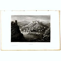
Tiflis.
View of Tiflis. Original steel engraving, published by Bibliographisches Institut Hildburghausen.
Date: Hildburghausen, ca. 1860
Selling price: ????
Please login to see price!
Sold in 2020
Plan of Attack & Defences of the South & North Sides of Harbour & Town of Sebastopol.
Scene during Crimean (Russo-Turkish) War 1853-1856. Bird's-eye plan of the harbour and town of Sebastopol Sevastopol) with the retreat of the Russians. Steel engraved pla...
Date: London, James S Virtue, 1860
Selling price: ????
Please login to see price!
Sold in 2017
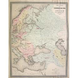
Carte generale des Chemins de fer de la Russie..
Fine map of Russia, Scandinavia, Germany, showing the early railway system of the area. From Atlas des Chemins de Fer published by Napoléon Chaix and printed by Imprimer...
Date: Paris 1863
Selling price: ????
Please login to see price!
Sold in 2008
Russland.
This is a rare decorative map of Russia with informative borders, published in Brockhaus' Illustrierter Handatlas .
Date: Leipzig, 1863
Selling price: ????
Please login to see price!
Sold in 2011

A set of 16 humorous woodblock prints from the Russian Empire's war with the French and British Empire's.
This set of 16 are from 1853 - 1863, mostly engraved by Joseph Swain. Joseph Swain was one of the most important woodblock engravers.Punch was responsible for the word se...
Date: London, 1853 - 1863
Selling price: ????
Please login to see price!
Sold in 2015
A set of 16 humorous woodblock prints from the Russian Empire's war with the French and British Empire's.
This set of 16 are from 1853 - 1863, mostly engraved by Joseph Swain. Joseph Swain was one of the most important woodblock engravers. Punch was responsible for the word s...
Date: London 1853 - 1863
Selling price: ????
Please login to see price!
Sold in 2015
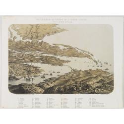
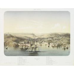
Vue générale du théatre de la guerre d'Orient dans la province de Kerson.
Panoramic View of Nicolaieff and Kerson Bay in the Ukraine. Including a numbered key (1-46) in lower part, mentioning all place names.Published by Wild, rue de la Banque ...
Date: Paris, Wild, c.1865
Selling price: ????
Please login to see price!
Sold in 2010
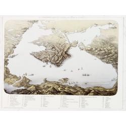
Vue panoramique du litoral de la Mer Noir.
Panoramic view of the Black Sea with a key 1-53 in lower margin, mentioning all place names.Published by Wild, rue de la Banque 15 près la Bourse, in Paris.
Date: Paris, Wild, c.1865
Selling price: ????
Please login to see price!
Sold in 2013
Siège de Sébastopol Vue générale. 2
Panoramic town-plan of the siege of Sebastopol. Chromolithograph after A Cassagne and V. Adam, printed by Lemercier. With a key 1-24 in lower margin.
Date: Paris, Morier, c.1865
Selling price: ????
Please login to see price!
Sold in 2013
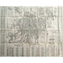
Guide du Voyageur (with rare large plans of Moscow)
French travel guide of St. Petersburg with the large and very rare town-plan of Moscow! "Nouveau Plan de Moscou avec Environs" published by Hoppe in 1867. The ...
Date: Paris, 1866
Selling price: ????
Please login to see price!
Sold in 2012
Carte de la Russie d'Europe et de la Turquie Théàtre de la Guerre en Oriens. . .
Very large, highly detailed and uncommon issue of the map by Brué depicting the progress of the war in the Ukraine, the Crimea and the Black Sea. Including Istanbul and ...
Date: Paris, London, ca. 1867
Selling price: ????
Please login to see price!
Sold in 2013
Guide du Voyageur en Russie (with plans of St. Petersburg, Moscow, and a map of Russia)
French travel guide to St. Petersburg with two large and very rare town-plans of St. Petersburg and Moscow! "Nouveau Plan de St. Petersbourg avec Environs" and...
Date: Paris, 1867
Selling price: ????
Please login to see price!
Sold in 2012
Danse Kalmouke sous la tente de la Princesse Tumêne.
Lithography from a rare book by Hommaire-de-Hell "Voyage à la mer Caspienne". Ignace-Xavier Morand Hommaire-de-Hell (1812-1848) was a traveler and geologist, w...
Date: Paris, Lemercier, 1868
Selling price: ????
Please login to see price!
Sold in 2010
Campement de nuit dans les steppes de la mer Caspienne. Voyage à la mer Caspienne par Mr et Mme Hommaire de Hell.
Lithography after a design by Gluck of a Kalmouk Buddhist Temple in the Republic of Kalmykia, the only Buddhist region in Europe. Lithography taken from "Voyage à l...
Date: Paris, Lemercier, 1868
Selling price: ????
Please login to see price!
Sold in 2011
Temple Kalmouk sur la rive gauche du Volga. Voyage à la mer Caspienne par Mr et Mme Hommaire de Hell.
Lithography after a design by Gluck of a Kalmouk Buddhist Temple in the Republic of Kalmykia, the only Buddhist region in Europe. Lithography taken from "Voyage à l...
Date: Paris, Lemercier, 1868
Selling price: ????
Please login to see price!
Sold in 2014
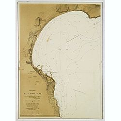
Mer Noire - Baie d'Odessa. . .
Detailed chart of the Bay and town of Odessa in the Ukraine. With soundings. According to the title the chart is copied from a Russian map made by Lieut. Belgavski. The c...
Date: Paris, 1869
Selling price: ????
Please login to see price!
Sold in 2012
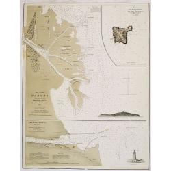
Mer Noire. Danube Bouches de la Branche Kilia. / Branche Sulina (Danube).
Two very detailed charts of the outlet of the Danube River into the black Sea. In upper right corner inset map of "Ilan Ada st ou Fido-Nisi ou Ile aux serpents. . . ...
Date: Paris, after 1869
Selling price: ????
Please login to see price!
Sold
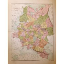
Russia in Europe.
A highly detailed map of Russia in the late 19th century. The provinces are separated by coloring. Published in Edinburgh by Adam & Charles Black
Date: Edinburgh, 1870
Selling price: ????
Please login to see price!
Sold in 2014
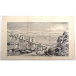
Suspension Bridge, Russia, Across the Dnieper at Kieff.
Fine lithograph of the wrought iron bar-chain suspension bridge erected by command of the Emperor of Russia. Currently, the bridge is in Kiev, Ukraine.
Date: 1870
Selling price: ????
Please login to see price!
Sold in 2015
