Browse Listings in Europe > Netherlands
![[No title - Insert map " Caerte van Een Gedeelte van Brabant"]](/uploads/cache/47915-250x250.jpg)
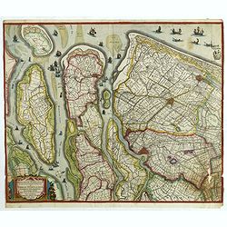
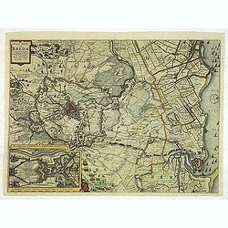
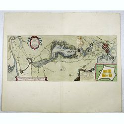
[No title - Insert map " Caerte van Een Gedeelte van Brabant"]
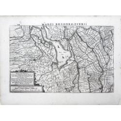
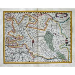
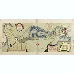
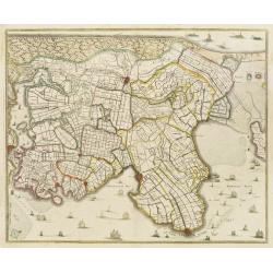
Map of the siege of Bergen op Zoom by Spinola showing the location of the quarters and a larger part of the area around Reimerswaal, Tholen and Steenbergen, lower right i...
Date: Amsterdam, 1622
Selling price: ????
Please login to see price!
Sold in 2022
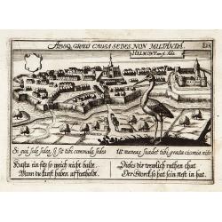
Helmond.
"View of the town with in the foreground a large stork. With a verse in two languages underneath the picture.The poet Daniel Meisner from Komotau started his Thesaur...
Date: Frankfurt 1623
Selling price: ????
Please login to see price!
Sold
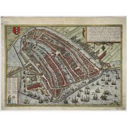
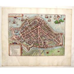
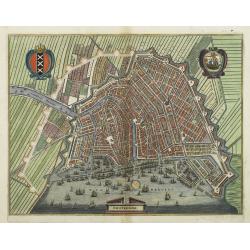
Amstelredamum, nobile Inferioris Germaniæ oppidum
A map of Amsterdam in bird-eye view, seen from the Northeast, the IJ river at front with many ships. Title and extensive description at top right, at bottom left legends ...
Date: Cologne, 1618-1623
Selling price: ????
Please login to see price!
Sold in 2022
![[Lot of 10 maps/plans] Hollandia Comitatus.](/uploads/cache/18973-(1)-250x250.jpg)
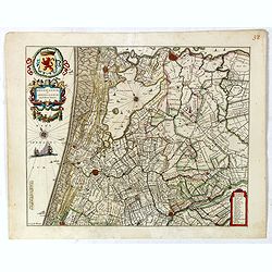
[Lot of 10 maps/plans] Hollandia Comitatus.
Matthäus Merian (1593-1650). Engraver and publisher of Frankfurt. Theatrum Europaeum 1629-1718, Topographie 1642-88, Gotofred Newe Archontologica Cosmica 1638 and 1649.An...
Date: Fankfurt, c. 1625
Selling price: ????
Please login to see price!
Sold in 2022
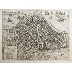
Hooren in Westvrieslant.
Attractive and decorative plan of Hoorn. Showing the town with the city walls, surrounding fields, and the harbour with sailing ships. Published in "Description de t...
Date: Amsterdam, 1625
Selling price: ????
Please login to see price!
Sold in 2012
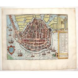
Die stadt Enchuijsen.
Detailed copper engraved city map of Enkuizen, Netherlands by Lodovico Guicciardini and published by Janssonius. Highly decorated with dozens of ships, windmills and a me...
Date: Amsterdam, Janssonius, 1625
Selling price: ????
Please login to see price!
Sold in 2013
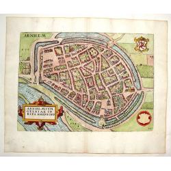
Arnhemium Gelriae in Ripa Rheni Opp.
Copper engraved city plan by Lodivico Guicciardini and published by Johannes Janssonius. Features the bird's-eye details of the city of Arnhem. Includes a prominent strap...
Date: Amsterdam, J. Janssonius, 1625
Selling price: ????
Please login to see price!
Sold in 2015
Hooren in Westvrieslant.
Copper engraved map by Lodovico Guicciardini and published by Janssonius. Detailed city map featring Hoorn, Netherlands. Includes god riding sea monster and dozens of de...
Date: Amsterdam, Janssonius, 1625
Selling price: ????
Please login to see price!
Sold in 2013
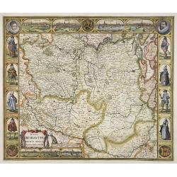
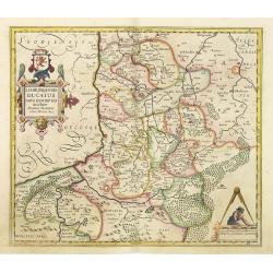
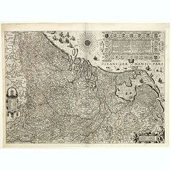
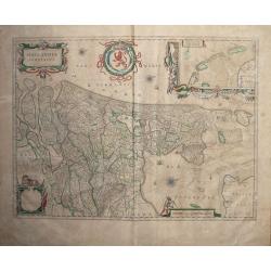
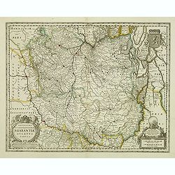
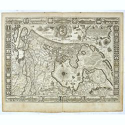
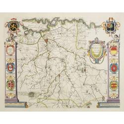
Nova Brabantiae Ducatus Tabula. . .
First and only edition with borders. This beautiful and very rare carte à figures map has been engraved by Dirk Gryp who engraved only three town views in the lower left ...
Date: Amsterdam, 1622-1627
Selling price: ????
Please login to see price!
Sold in 2009
Episcop. Ultraiectinus.
A very detailed map based on Utrecht. Scale cartouche held by a surveyor. Based on the map by B.F.van Berckenrode (1620-21) and engraved by the master engraver Evert Sijm...
Date: Amsterdam, after 1629
Selling price: ????
Please login to see price!
Sold in 2019
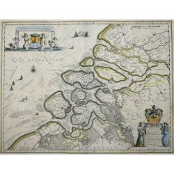
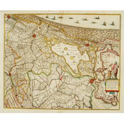
Novissima Delflandiae, Schielandiae..
A very nice map showing the southern part of the province of Holland.Mercator was born in Rupelmonde in Flanders and studied in Louvain under Gemma Frisius, Dutch writer,...
Date: Amsterdam, 1629
Selling price: ????
Please login to see price!
Sold in 2020
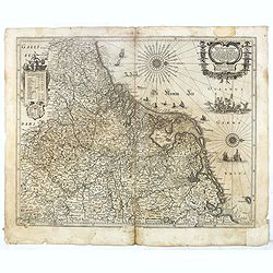
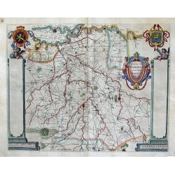
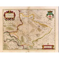
Zutphania Comitatus.
Nice map of the county of Zutphen in Gelderland. The map shows the eastern part of the province of Gelderland as well as a smal part of Germany. Important cities are Arnh...
Date: Amsterdam 1629
Selling price: ????
Please login to see price!
Sold
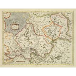
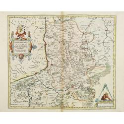
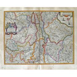
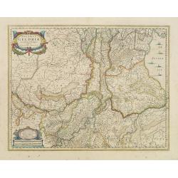
Ducatus Geldriae novissima descriptio
Copper engraved map of Gelderland, but also including Utrecht, and parts of Brabant. It shows many cities (like Nijmegen, Eindhoven, Zutphen, Zwolle, etc.), roads, rivers...
Date: Amsterdam, 1629
Selling price: ????
Please login to see price!
Sold in 2012
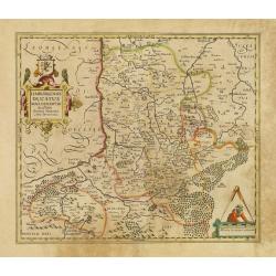
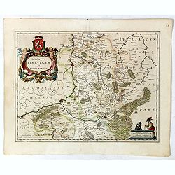
Limburgensis Ducatus Nova Descriptio.
Map of Limburg, prepared by the Antwerp expert in law and mathematics Aegidius Martini.
Date: Amsterdam, 1630
Selling price: ????
Please login to see price!
Sold in 2020
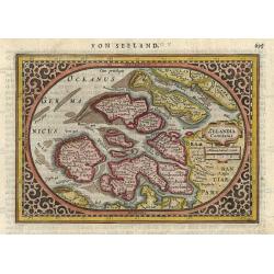
Zelandia Comitatus.
Based on the map by Van Deventer. For the first time a road connection between Flushing, Middelburg and Arnemuyden is shown. Mercator pays much attention to the area of s...
Date: Amsterdam, 1630
Selling price: ????
Please login to see price!
Sold in 2014
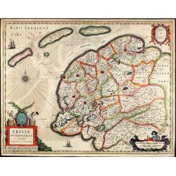
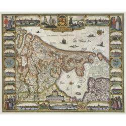
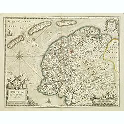
Frisia Occidentalis Auctoribus Adriano Metio et Gerardo Freitag.
Original old colored map of West Friesland with the islands Vlieland, Terschelling und Ameland. With 3 cartouches, two sailing ships, and a compass rose. Published by H. ...
Date: Amsterdam, 1630
Selling price: ????
Please login to see price!
Sold in 2009
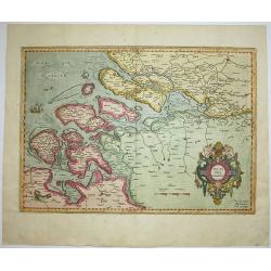
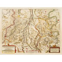
Descriptio fluminum Rheni, Vahalis et Mosae.
Extremely rare edition of this fine map in central Netherlands where the three great rivers flow to within but a few kilometers of each below Wesel. The scale allows most...
Date: Amsterdam, 1630
Selling price: ????
Please login to see price!
Sold in 2022
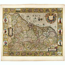
XVII Provinciarum Inferioris Germaniae, Nec non totius tractus . . .
Rare edition of Visscher's map of the XVII Provinces. The re-edition of this map, dated 1630, 1650 and 165. The 1630 edition served as a general survey of the Seventeen P...
Date: Amsterdam, 1630
Selling price: ????
Please login to see price!
Sold in 2020
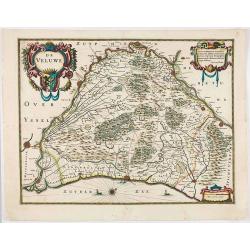
De Veluwe.
Very rare and early map of the Veluwe published by Henricus Hondius. Decorative title cartouche with a dedication to Jan van Wely, who was born in Barneveld but active in...
Date: Amsterdam, ca. 1630
Selling price: ????
Please login to see price!
Sold in 2020
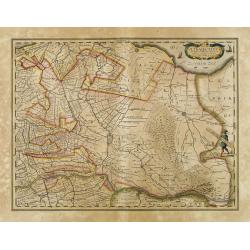
![No title. [Brabant]](/uploads/cache/12186-250x250.jpg)
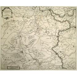
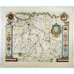
No title. [Brabant]
Brabant, Gulick and Cleve.
Date: Amsterdam, 1630
Selling price: ????
Please login to see price!
Sold in 2015

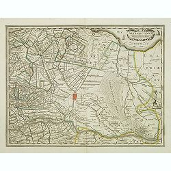
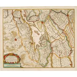
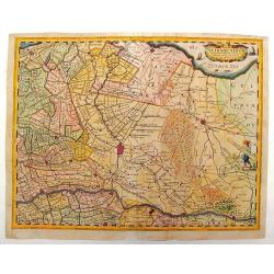
Rhinolandiae, Amstelandiae, et ..
Centered on The Hague, Leiden, Haarlem, Amsterdam, Gouda, etc. West to the top. Prepared by Balthasar Floris van Berkenrode.
Date: Amsterdam, 1630
Selling price: ????
Please login to see price!
Sold in 2008
Episcop. Ultraiectinus.
Based on the map by B.F.van Berckenrode (1620-21).
Date: Amsterdam, 1630
Selling price: ????
Please login to see price!
Sold
Limburgensis Ducatus Nova Descriptio.
Map of Limburg, prepared by the Antwerp expert in law and mathematics Aegidius Martini.
Date: Amsterdam, 1630
Selling price: ????
Please login to see price!
Sold in 2015
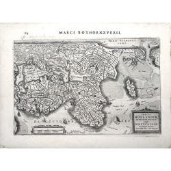
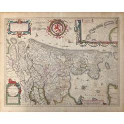
Comitatus Hollandiae.
A first edition of one of the most decorative carte à figures maps of Holland. Superbly engraved by Abraham Goos. The map is framed on al sides by decorative borders. The...
Date: Amsterdam, 1630
Selling price: ????
Please login to see price!
Sold in 2009
Geldria et Transysulana.
One of the earliest maps of Gelderland and Overijssel, prepared by Gerard Mercator. With his signature in lower left corner.
Date: Amsterdam, 1630
Selling price: ????
Please login to see price!
Sold in 2014
Limburgensis Ducatus Nova Descriptio.
Map of Limburg, prepared by the Antwerp expert in law and mathematics Aegidius Martini.
Date: Amsterdam, 1630
Selling price: ????
Please login to see price!
Sold in 2008
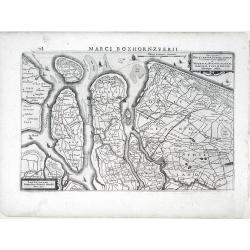
Insular Dordracencis, Alblasser, Crimper, Clundert. . .
A very nice map showing the southern part of the province of Noord Holland. The map is dated 1629. Henricus Hondius gives credit to Balthasar Florisz. van Berckenrode did...
Date: Amsterdam, 1630
Selling price: ????
Please login to see price!
Sold in 2012
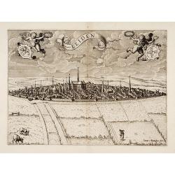
Leiden.
Very rare and separately published print of Leiden. In lower right corner signed "Ioannes à Doetinckum fecit."
Date: Amsterdam, 1630
Selling price: ????
Please login to see price!
Sold
Belgii sive Germaniae Inferioris accuratissima tabula.
Very rare and very decorative map with in the right and left borders costumed figures and town plans alternately. In top and bottom border town plans and views.Separate p...
Date: Amsterdam, 1631
Selling price: ????
Please login to see price!
Sold in 2024
Novus XVII Inferioris Germaniae Provinciarum Typus.
One of the most decorative maps of present day Netherlands, Belgium and Luxembourg.With the signature of "Willem Jansz. op't Water in de Vergulde Zonnewyzer."Su...
Date: Amsterdam, ca. 1631
Selling price: ????
Please login to see price!
Sold in 2018
Belgii Sive Germaniae Inferioris accuratissima tabula.
Wonderful and detailed map with the title cartouche in the shape of a shield surrounded by the coats of arms of the XVII Provinces and the names of the Provinces in a ban...
Date: Amsterdam, 1631
Selling price: ????
Please login to see price!
Sold in 2019
Frisia occidentalis.
Finely engraved map of the northern part of the Netherlands. The map has no text on the verso and is a very good and dark impression, indicating the map originates from t...
Date: Amsterdam, 1631
Selling price: ????
Please login to see price!
Sold in 2013
Novissima Tabula Insular, Dordracensis, Alblasser, Crimper, Clundert etc...
A small, highly detailed map of Southern Holland published by Henricus Hondius(fl. 1624-1651) based on the survey by Floriszoon van Berckenrode. Includes the cities of Br...
Date: Amsterdam, 1632
Selling price: ????
Please login to see price!
Sold in 2010
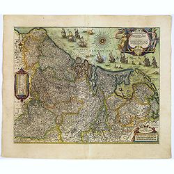
Belgicarum Provinciarum Descriptio. Gedruckt te Haerlem. . .
Very rare 2nd state of the map of the Low Countries, first published by Johannes and Baptist van Doetecum, in Haarlem 1588. This state of the map was only discovered in 1...
Date: Amsterdam, 1588/ The Hague, Henricus Hondius, 1632
Selling price: ????
Please login to see price!
Sold in 2019
Totius Hollandiae Septentrionalis vulgo Westfrisiae novissima tabula. . .
A small, highly detailed map of Northern Holland, including the Westfrisia region, published by Henricus Hondius(fl. 1624-1651) based on the survey by Floriszoon van Berc...
Date: Amsterdam, 1632
Selling price: ????
Please login to see price!
Sold in 2010
Novissima Delflandiae, Schielandiae et circumiacentium insularum ut Voornae, Overflackeae, Goeree, Iselmonde aliarumque tabula.
A small, highly detailed map of Southern Holland published by Henricus Hondius(fl. 1624-1651) based on the survey by Floriszoon van Berckenrode. Includes the cities of Ro...
Date: Amsterdam, 1632
Selling price: ????
Please login to see price!
Sold in 2010
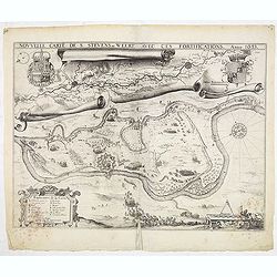
Nouvelle carte de S. Stevens=Weert avec ces fortifications. Anno 1633.
A very rare map of the siege of Stevensweert. In upper part a second map of the river Maas from Maastricht until Venlo. Prepared P. Chatel and F. Boullain, engraved by A....
Date: Brussels, 1633
Selling price: ????
Please login to see price!
Sold in 2015
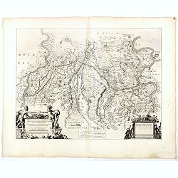
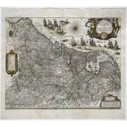
Carte des Duchés de Gueldres et Cleves, comté de Zutphen Frise et Overyssel.
rare map of Gelderland, Overijssel, Limburg, Groningen and part of German territory. West to the top. The title cartouche printed from a separate plate.RARE.
Date: Paris, 1634
Selling price: ????
Please login to see price!
Sold in 2013
Belgii sive Germaniae Inferioris..
An extremely rare, finely engraved map. According to van der Heijden, only 5 other copies are known. The map is copied by Cornelis Danckerts II after a map by Henricus Ho...
Date: Amsterdam, 1634
Selling price: ????
Please login to see price!
Sold in 2021
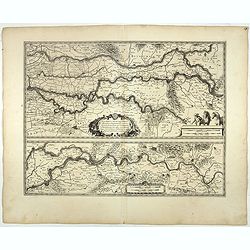
Fossa quae a Rheno ad Mosam duci caepta est Anno CLC ICCXXVII.
FIRST STATE without the coats of arms and it final title "Fossa Sanctae Mariae." - Only included in a few early editions.Detailed map of part of the country bet...
Date: Amsterdam, 1634
Selling price: ????
Please login to see price!
Sold
ULTRAIECTUM DOMINIUM Excudit Guiljelmus Blaeu.
A highly detailed map of Utrecht and its surroundings of The Netherlands. From a German edition of Blaeu's atlas.
Date: Amsterdam, 1634
Selling price: ????
Please login to see price!
Sold in 2012

Novus XVII Inferioris Germaniae Provinciarum Typus.
Willem Blaeu published this map in 1608 as a wall map with figured borders. When later, in 1630 he needed a general map of the Netherlands for his first atlas, the Append...
Date: Amsterdam, 1634
Selling price: ????
Please login to see price!
Sold in 2020
Novus XVII Inferioris Germaniae Provinciarum Typus
One of the most decorative maps of the Benelux countries. Title in a cartouche with Mercury and Mars at top right, with dedication and the name of 'Guliel. Blaeu'. Bottom...
Date: Amsterdam, 1630/1634
Selling price: ????
Please login to see price!
Sold in 2022
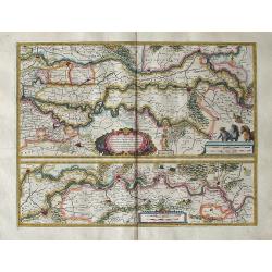
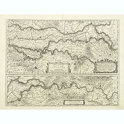
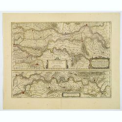
Tractus RHENI et MOSAE totusque VAHALIS ... Exc Guiljel Blaeuw.
A highly attractive map. The two maps depict the area around the Rhine, Waal, and Meuse Rivers in The Netherlands. Shows all the villages, fortresses, cities and castl...
Date: Amsterdam, (1630) 1634
Selling price: ????
Please login to see price!
Sold in 2011
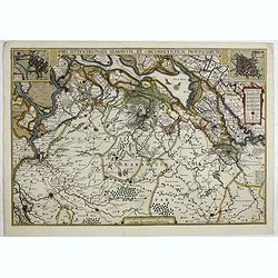
Pars Septentrionalis Brabantiae, et circumiacentium Provinciarum.
Rare map of the area between Mechelen and the Schelde in the West and the Maas and the river Aade in the East, reaching to Dordrecht in the North and to Eindhoven in the ...
Date: Amsterdam, after 1629 - 1634
Selling price: ????
Please login to see price!
Sold in 2014
Geldria Ducatus et Zutfania Comitatus.
A highly decorative and detailed map of the Gelderland and Zutphen in The Netherlands. This is variant "B" of the map with the right coat of arms above the tit...
Date: Amsterdam, (1631) 1634
Selling price: ????
Please login to see price!
Sold in 2011
Quarta pars Brabantiae cujus caput Sylvaducis. . .
This is a rare first state of Blaeu's map of Brabant (north). This marvelous map is only found in the relatively scarce Novus Atlas by Willem Blaeu, published in Amsterd...
Date: Amsterdam, 1634
Selling price: ????
Please login to see price!
Sold in 2012
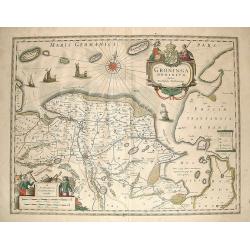
Groninga Dominium
A nice decorative map displaying Groningen in Netherlands, a part of East Frisia, Emden as well as the adjacent areas. The map is richly decorated with very beautiful car...
Date: Amsterdam, 1635
Selling price: ????
Please login to see price!
Sold in 2009
Zelandia Comitatus.
Finely engraved oval map showing the south-western part of the Netherlands, Province of Zeeland. Strapwork title cartouche and intricate surrounding border. German text o...
Date: Amsterdam 1635
Selling price: ????
Please login to see price!
Sold
Hollandia Comitatus.
Highly detailed regional map of Holland, with an inset of the Dutch Islands of Texel, Vlielandt, etc. Includes a rampant lion, 3 cartouches, sailing ships and 3 compass r...
Date: Amsterdam, 1635
Selling price: ????
Please login to see price!
Sold in 2014
Zeelandia Comitatus.
Attractive example of Blaeu's map of Zeeland. Extends from Calais and Douay in the west to Louven and Bergen op Zoom in the east. Title cartouche, 2 coats of arms, compas...
Date: Amsterdam, 1635
Selling price: ????
Please login to see price!
Sold in 2013
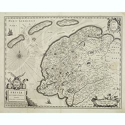
Frisia occidentalis.
This fine map of Friesland was made by the Franeker scientist Adrian Metius. The main towns are shown by miniature plan, attractive title cartouche bottom left, key carto...
Date: Amsterdam, 1637
Selling price: ????
Please login to see price!
Sold in 2012
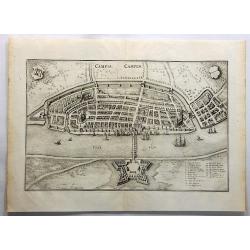
Campia Campen. (Kampen)
Striking view of Kampen on the Ysel River, with 2 coats of arms (one blank) and several sailing ships. Shows town plan, fortified walls, bridge, canals, etc. Matthäus M...
Date: Frankfurt, 1638
Selling price: ????
Please login to see price!
Sold in 2019
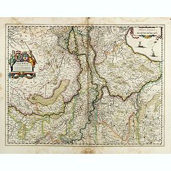
Novissima et Accuratissima Brabantiae Ducatus Tabula.
North is to the right. Like all other maps of Brabantiae Ducatus, it encloses the area between the rivers Rhine, Maas and Schelde, with Namur as the most southern town. O...
Date: Amsterdam, 1638
Selling price: ????
Please login to see price!
Sold in 2012
Geldria Ducatus et Zutphania Comitatus.
Map of Gelderland orientated west at the top, including Northern Limburg, eastern part of Brabant, Veluwe and Zutphen. Including the towns of Utrecht, Enschede, Rhunbeck,...
Date: Amsterdam, 1638
Selling price: ????
Please login to see price!
Sold in 2017
Tabula Bergarum ad Zoman Stenbergae.
A small section of the center has been rubbed: otherwise excellent. Rather rare to see an early road map in this time. It shows the city of Bergen op Zoom in Brabant.As W...
Date: Amsterdam, 1638
Selling price: ????
Please login to see price!
Sold in 2017
Tractus Rheni et Mosae totusq Vahalis.
Shows that part of the central Netherlands where the three great rivers flow to within but a few kilometers of each below Wesel. The scale allows most of the larger towns...
Date: Amsterdam, 1638
Selling price: ????
Please login to see price!
Sold in 2017
Fossa Eugeniana que a Rheno ad Mosam..
Detailed map of part of the country between rivers Rhine and Meuse showing a canal to be dug between 1626 and 1628 between Rheinberg in Germany and Venlo. A deficiency of...
Date: Amsterdam 1639
Selling price: ????
Please login to see price!
Sold
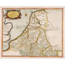
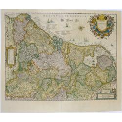
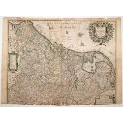
Belgii Veteris Typus ex conatibus..
Ancient map of present Netherlands, Belgium and Luxemburg. Engraved by Petrus Kaerius, after design of Abraham Ortelius. Fine title cartouche.
Date: Amsterdam 1639
Selling price: ????
Please login to see price!
Sold
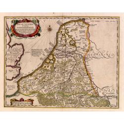
Belgii Veteris Typus ex conatibus..
Ancient map of present Netherlands, Belgium and Luxemburg. Engraved by Petrus Kaerius, after design of Abraham Ortelius. Fine title cartouche.
Date: Amsterdam 1639
Selling price: ????
Please login to see price!
Sold
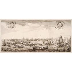
Queen Maria of France arriving at Amsterdam.
Panoramic view of the city from 't IJ. On the foreground extensive shipping being the arrival on August 31, 1638.The print was published in commemoration of Maria de 'Med...
Date: Amsterdam 1639
Selling price: ????
Please login to see price!
Sold
Rhinolandiae, Amstelandiae et ..
Centered on The Hague, Leiden, Haarlem, Amsterdam, Gouda, etc. West to the top. Prepared by Balthasar Floris van Berkenrode.
Date: Amsterdam, 1639
Selling price: ????
Please login to see price!
Sold
Comitatus Zutphania.
A very detailed map of this area, including Arnhem, Nijmegen, Zutphen, Groenlo, etc.
Date: Amsterdam, 1639
Selling price: ????
Please login to see price!
Sold in 2022
Novissima Tabula Insular Dordracensis. . .
The countship of Holland was subdivided into a number of bailiwicks. The most southerly bailiwick, bordering on Brabant was named Zuid-Holland. Many floods changed the ap...
Date: Amsterdam, 1639
Selling price: ????
Please login to see price!
Sold in 2021
La Hollande Septentrionale.
Large map of the northern part of the province "Holland" in the Netherlands. The map comes from the "Atlas Novus" originally published by Janssonius i...
Date: Amsterdam, 1639
Selling price: ????
Please login to see price!
Sold in 2011
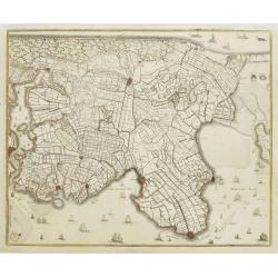
No title: Map of northern tip of Holland
The northern tip of Holland or West Friesland. West to the top. Including Amsterdam, Alkmaar, Hoorn, Enkhuizen, etc. Many ships in the Noord- and Zuiderzee.
Date: Amsterdam 1639
Selling price: ????
Please login to see price!
Sold
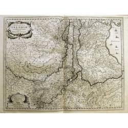
Ducatus Geldria.
West to the top. Including Gelderland, but also the provinces of Utrecht, Gelderland and part of Brabant. Engraved by the master-engraver Abraham Goos.
Date: Amsterdam, 1639
Selling price: ????
Please login to see price!
Sold in 2019
Episcop Ultraiectinus, Auct. Balthazaro Florentio a Berkenrode.
Highly detailed copper engraved map featuring the area around the city of Utrecht. This map gives several details concerning rivers, canals, cities and villages. This map...
Date: Amsterdam, 1628 /1640
Selling price: ????
Please login to see price!
Sold in 2014
Comitatus Hollandiae novissima description Designatore Balthazaro Florentio a Berckenrode Anno Domini 1629.
Highly detailed regional map of Holland, showing the area around Amsterdam, Utrecht, Rotterdam, with an inset upper right corner of the Dutch Islands of Texel, Vlielandt....
Date: Amsterdam, 1640
Selling price: ????
Please login to see price!
Sold in 2020
Amsterdam.
Bird's eye view of the busy harbour of Amsterdam with the city shown in plan. Individual buildings can be seen with gardens behind them. Clearly shows the canal system, c...
Date: Frankfurt, 1640
Selling price: ????
Please login to see price!
Sold in 2009
Hollandia.
The Allardt edition of Blaeu's map of Holland, first published in 1604, being the oldest Dutch map to include town views as decorative borders. The top and bottom borders...
Date: Amsterdam, 1640
Selling price: ????
Please login to see price!
Sold in 2024
Descriptio fluminum Rheni, Vahalis et Mosae. . .
A fine map of central Netherlands where three great rivers flow to within but a few kilometres of each below Wesel. (The Rhine, the Waal and the Meuse Rivers). The scale ...
Date: Amsterdam, ca 1640
Selling price: ????
Please login to see price!
Sold in 2019
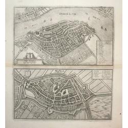
Dordracum (Dordrecht) and Briela (Briele)
Nice city plan of Dordrecht and Brielle, detailed with buildings houses, walls and gardens.
Date: Frankfurt, ca. 1645
Selling price: ????
Please login to see price!
Sold in 2008
Nieuwe Kaerte van Breda belegert door syne Altesa Frederick Hendrick van Nassou Prince van Orangien . . .
This very rare map appeared only in one atlas: Belgium sive Germania Inferior continens Provincias singulares Septemdecim. iuxta artem Geographicam perfectissime descript...
Date: Amsterdam, 1645
Selling price: ????
Please login to see price!
Sold in 2012
Rhenolandiae et Amstellandiae.
Encompasses the area between 's-Gravenhage and Gouda in the south, to Beverwijk in the north. Large expanse of the Haarlemmermeer occupies the center of the plate. A very...
Date: Amsterdam, 1645
Selling price: ????
Please login to see price!
Sold in 2019
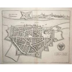
Neomagum (Nijmegen)
Nice city plan of Nijmegen at the Waal river. Detailed with buildings houses, walls and gardens and a view of the city in the right upper corner.
Date: Frankfurt, ca. 1645
Selling price: ????
Please login to see price!
Sold in 2008
Quarta pars Brabantiae cujus caput Sylvaducis.
The coat of arms of Brabant and 's-Hertogenbosch appear on the map. As this is an early state of this map, the municipal arms in the columns on right and left-hand side h...
Date: Amsterdam, 1645
Selling price: ????
Please login to see price!
Sold in 2018
Tabula Bergarum ad Zoman Stenbergae.
This map shows the city of Bergen op Zoom in Brabant.
Date: Amsterdam, 1645
Selling price: ????
Please login to see price!
Sold in 2018
Ducatus Limburgum.
Decorative map of Belgium that is centered roughly on the Meuse River (Latin Mosa) and its cities of Hoy, Liege, and Maastricht. Finely detailed to show numerous towns an...
Date: Amsterdam, 1645
Selling price: ????
Please login to see price!
Sold in 2019
Quarta pars Brabantiae cujus caput Sylvaducis.
A good and dark impression in strong original colors.The third state. The coat of arms of Brabant and 's-Hertogenbosch appears on the map. The municipal arms in the colum...
Date: Amsterdam, 1645
Selling price: ????
Please login to see price!
Sold in 2008
