Browse Listings in Europe > Eastern Europe > Balkans
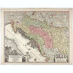
Nova et accurata.. Dalmatiae, Croatiae, Sclovoniae, Bosniae. . .
A finely engraved and large detailed map including the western part of the river Donau. Two decorative cartouches adorn the lower corners of the map. One with coats of ar...
Date: Augsburg, 1760
Selling price: ????
Please login to see price!
Sold in 2023
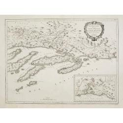
Nouvelle Carte de la Partie Occidentale de Dalmatie, dressee sur les lieux.
Finely and crisply engraved map depicting part of the Dalmatian coastline and its islands between Zadar and Omis, south of Split.In the lower right corner the island Vis,...
Date: Venice, 1776 - 1784
Selling price: ????
Please login to see price!
Sold in 2010
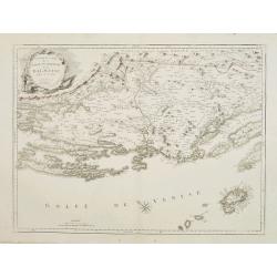
Nouvelle Carte de la Partie Orientale de Dalmatie, dressée sur les lieux.
Finely and crisply engraved map depicting the southern part of the Dalmatian coastline and its islands.Encompassing the area from the southern half of Brac island to the ...
Date: Venice, 1776 - 1784
Selling price: ????
Please login to see price!
Sold
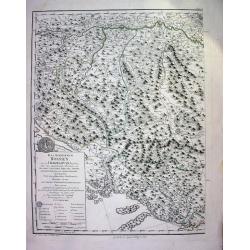
Das Koenigreich Bosnien, und die Herzegovina (Rama)
Large copper-engraved wallmap showing Bosnia and Herzegovina, large parts of Dalmatia, the Republic of Dubrovnik, parts of Croatia, Slavonia, Serbia, Albania and Macedoni...
Date: Vienna, 1788
Selling price: ????
Please login to see price!
Sold
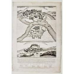
Descrizione della fortezza, e città di Belgrado.
Scarce publication printed just before the Austrian attack to Beograde in 1789. The print is divide in three parts called « Prospetto della fortezza e parte della città...
Date: Venice, 1788
Selling price: ????
Please login to see price!
Sold in 2019
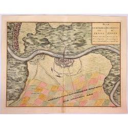
Plan van de Veldtslag van Zenta.
A map of the fortifications and surrounding area of troop orders during the battle of Senta in 1697, between the Imperial and Turkish troops .The birds-eye plan is from J...
Date: Paris, ca. 1790
Selling price: ????
Please login to see price!
Sold in 2018
![[BALKANS 1839] HARTIS TIS TOYRKIAS KAI ELLADOS. . . BIENNI 1839.](/uploads/cache/85299-250x250.jpg)
[BALKANS 1839] HARTIS TIS TOYRKIAS KAI ELLADOS. . . BIENNI 1839.
A very rare copper engraved map of the southern Balkans - European Turkey and Greece, by K.M.Koyma, for the Greek edition of the Geography by A.Balbi, 1839 in Vienna. Cov...
Date: Vienna, 1839
Selling price: ????
Please login to see price!
Sold in 2021
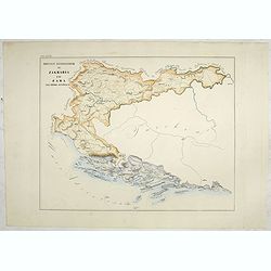
Province ecclesiastiche di Zagrabia e di Zara nell' Impero Austriaco (Tav LXXIII)
This large-format Zagrabia and Zara map is finely engraved and beautifully colored and was prepared by Girolamo Petri, a lawyer who served as a senior official within the...
Date: Rome, 1858
Selling price: ????
Please login to see price!
Sold in 2020
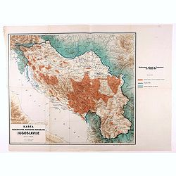
Karta Federativne Narodne Republike Jugoslavije.
Rare map of Yugoslavia. With color key. The map was made in the year of the 1941 invasion of Yugoslavia, also known as the April War was a German-led attack on the Kingdo...
Date: Yugoslavia, 1946
Selling price: ????
Please login to see price!
Sold in 2021
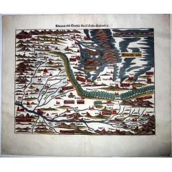
SCLAVONIA ODER WINDISCH MARCK. . .
A detailed and attractive wood block map by Munster of the region that included Istria and extends to include some of Slovenia, Croatia, Dalmatia, and northeastern Italy....
Date: Basel, ca 1550
Selling price: ????
Please login to see price!
Sold in 2021
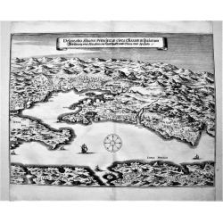
Delineatio Situsve Provinciae Clissam & spalatum. Abbildung oder Situation der Landschafft Clissa vnd Spalato.
An important copper engraving from Merian's Theatrum Europäum, 1652 (see Fauser Nr. 13238). It shows a bird's-eye view of the region of Split with the islands of Solta u...
Date: Frankfurt a. M., 1654
Selling price: ????
Please login to see price!
Sold in 2019
