Browse Listings in Europe > British Isles > Ireland
Udrone Irlandiae in Catherlagh Baronia.
Depicts present day County Carlow in Leinster Province & Catherlaugh which is now Carlow. The title is surrounded by a strap work design cartouche topped with caliper...
Place & Date: Amsterdam 1639-44.
Selling price: $160
Sold
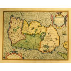
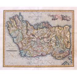
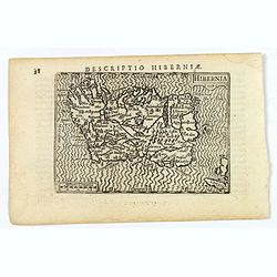
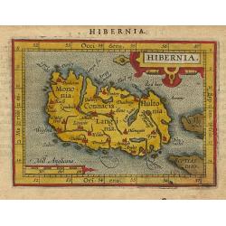
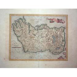
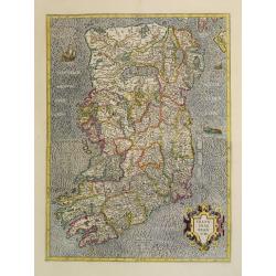
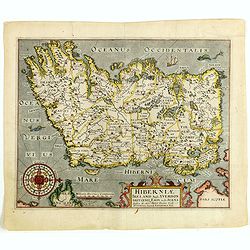
Eryn - Hiberniae, Britannicae Insulae, Nova Descriptio - Irelandt.
A beautiful map of Ireland from Ortelius' "Theatrum Orbis Terrarum." This map is significant as the first separate printed map of Ireland. It’s also one of th...
Place & Date: Antwerp, 1574
Selling price: $900
Sold in 2012
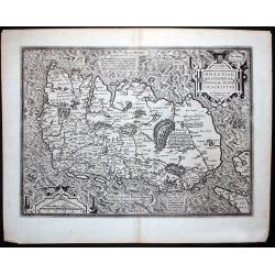
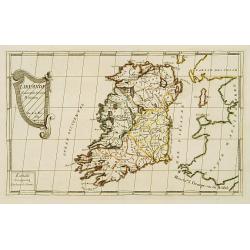
Hiberniae Britannicae insulae nova descriptio.
Copied from Mercator's influential wall map of the British Isles of 1564, this is certainly the best map of Ireland of the 16th century.
Place & Date: Antwerp, 1574
Selling price: $870
Sold in 2015
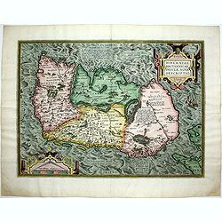
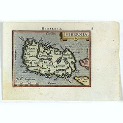
Eryn - Hiberniae, Britannicae Insulae, Nova Descriptio - Irelandt
A beautiful map of Ireland from Ortelius' "Theatrum Orbis Terrarum" or Atlas of the whole world. This is one of the earliest maps of Ireland to present it with ...
Place & Date: Antwerp, 1587
Selling price: $1300
Sold in 2011
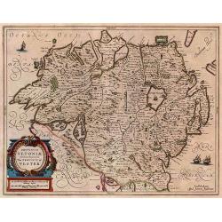
Ultoniae Orientalis Par.
Decorative map of the Ulster Region.From the first edition of Mercator's Atlas, published in 1595. The map features an ornate title cartouche with a scale below. The map...
Place & Date: Duisberg, 1595
Selling price: $600
Sold
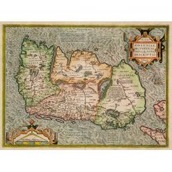
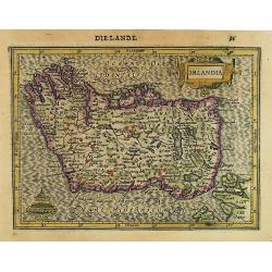
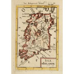
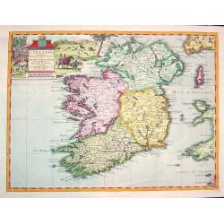
Irlandia Regnum.
Striking map of Ireland, with north oriented to the right and featuring a splendid ribbon style title banner cartouche. Fully engraved with topographical features and a s...
Place & Date: Amsterdam, 1595
Selling price: $265
Sold in 2017
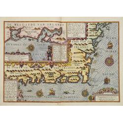
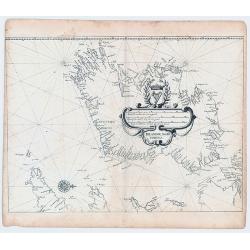
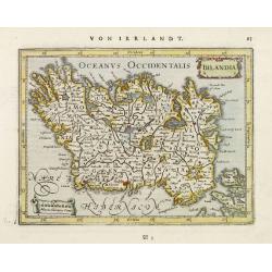
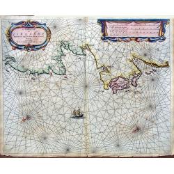
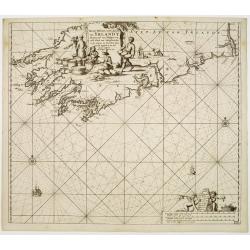
Beschrivinge der zeecusten van de Züijtsijde ende de Oos t-sijde van Irlandt. . . .
A detailed chart of the coast of the western side of Ireland. Decorated by a title cartouche and scale cartouche, four compass roses, several vessels and sea monsters, an...
Place & Date: Amsterdam, C.Claes, 1596
Selling price: $10000
Sold in 2008
Hiberniae Britannicae insulae nova descriptio.
Copied from Mercator's influential wall map of the British Isles of 1564, this is certainly the best map of Ireland of the 16th century.
Place & Date: Antwerp, 1598
Selling price: $1450
Sold in 2009
Hiberniae Britannicae insulae nova descriptio.
Copied from Mercator's influential wall map of the British Isles of 1564, this is certainly the best map of Ireland of the 16th century.Dare to go in Black. All early map...
Place & Date: Antwerp, 1598
Selling price: $500
Sold in 2018
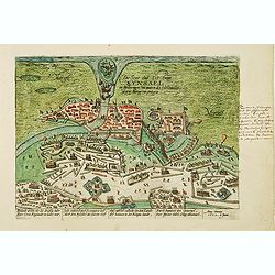
Die Stat und Vestung Kynsael.. Ihrlandt welchs vbr die dreissig Jahr der Cron England zu wider war. . .
Showing siege of Kinsale on 8 January 1602, when the Spanish forces surrender to the English. The Battle of Kinsale was a decisive turning point in Irish history, bringin...
Place & Date: Cologne, 1602
Selling price: $500
Sold in 2012
Irlandiae Regnum.
Two fine and early separate maps of southern and northern part of Ireland, can be joined.Mercator was born in Rupelmonde in Flanders and studied in Louvain under Gemma Fr...
Place & Date: Amsterdam 1606
Selling price: $420
Sold
Hibernia.
An attractive miniature map of the island of Ireland, published by Petrus Bertius, in Amsterdam at the beginning of the seventeenth century.Ireland is seen 'lying on its ...
Place & Date: Amsterdam, 1606
Selling price: $105
Sold in 2019
(Irlandiae Regnum - Northern part of Ireland)
Expertly engraved map of Ireland, being the top sheet of Mercator's two-sheet map of Ireland, including sailing ships and a sea monster. From an early edition of Mercator...
Place & Date: Amsterdam, 1607-1608
Selling price: $275
Sold in 2020
Irlandia.
Map of the Ireland from the first French-text edition of Jodocus Hondius' Atlas Minor. Oriented with West on top.Shortly after the publication of the big folio-atlases th...
Place & Date: Amsterdam, 1608
Selling price: $100
Sold in 2018
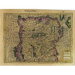
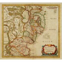
Ultonia Conatia et Media.
Map of Northern Ireland from the first French-text edition of Jodocus Hondius' Atlas Minor.Shortly after the publication of the big folio-atlases the need was apparently ...
Place & Date: Amsterdam, 1608
Selling price: $60
Sold in 2017
Hiberniae V. Tabula.
Map depicting the southern part of Ireland, extending northwards as far as Galway Bay in the west and Wicklow in the East.From the first French-text edition of Jodocus Ho...
Place & Date: Amsterdam, 1608
Selling price: $150
Sold in 2013
Hiberniae Britanicae Insulae Nova Descriptio Eryn Irlandt.
Published in Cologne by J. Bussemacher from 'Geographisch Handtbuch' based upon Mercator's map of the British Isles from 1564.Matthias Quad (1557-1613), was a map publish...
Place & Date: Cologne, 1608
Selling price: $700
Sold in 2018
Hibernia.
Miniature map of Ireland with major cities named. North is oriented to the right of the map. Sea is stipple engraved. Strapwork title cartouche at upper right. Latin text...
Place & Date: Antwerp 1609
Selling price: $100
Sold
Hibernia.
Miniature map of Ireland with major cities named. North is oriented to the right of the map. Sea is stipple engraved. Strap work title cartouche at upper right. Latin tex...
Place & Date: Antwerp, 1609
Selling price: $125
Sold in 2017
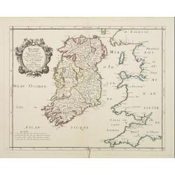
Irlandiae regnum.
One of the earliest maps of Ireland.
Place & Date: Amsterdam 1610
Selling price: $1200
Sold
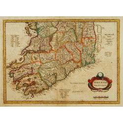
Hiberniae Ireland Anglis Yuerdon Britannis Erin incolis Ierna Orpheo & Arist. Iris Diodoro Siculo Juverna Juvenali Joyernia Ptol.Christopher Saxton & William Hole
One of the earliest obtainable maps of Ireland. Oriented with West at the top. Highly detailed.This map of Ireland is derived from Baptista Boazio's map of Ireland dating...
Place & Date: London, 1610
Selling price: $350
Sold in 2013
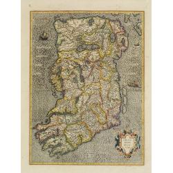
Irlandiae regnum. (2-sheets)
A early and large scale, two-sheet map of Ireland, which can be joined.The maps are richly engraved with a moiré pattern in the seas and strong topographical features in...
Place & Date: Amsterdam, 1610
Selling price: $800
Sold in 2016
Irlandiae Regnum.
Gerard Mercator's map of Ireland from the Mercator Hondius atlas with Latin text printed on the back. A fine, early map of Ireland with west at the top of the map. This i...
Place & Date: Duisberg, Amsterdam, 1587-1610
Selling price: $600
Sold in 2015
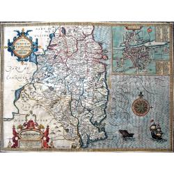
The countie of Leinster with the citie Dublin described.
Beautifully engraved map of eastern Ireland. With Lough Ree and Lough Derg, and Limerick as the most western point of the map. An inset plan shows on of the earliest prin...
Place & Date: London, ca. 1612
Selling price: $415
Sold in 2019
Irlandiae Regnum.
Fine map of southern part of Ireland.Mercator was born in Rupelmonde in Flanders and studied in Louvain under Gemma Frisius, Dutch writer, astronomer and mathematician. T...
Place & Date: Amsterdam, c. 1613
Selling price: $200
Sold in 2012
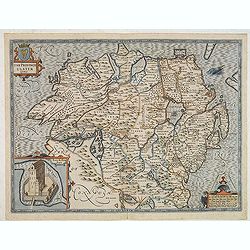
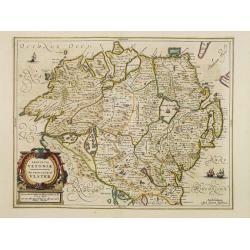
The province of Ulster described.
A most decorative map of the County of Ulster in Northern Ireland. One of four maps in this auction of the Irish provinces included in Speed’s atlas, it contains an ins...
Place & Date: London, 1610 - 1616
Selling price: $550
Sold in 2013
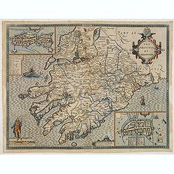
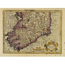
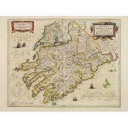
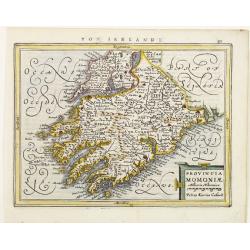
The province of Mounster.
A most decorative map of the Irish province of Munster, located in the southwest of the island. One of four maps in this auction of the Irish provinces included in Speed�...
Place & Date: London, 1610 - 1616
Selling price: $550
Sold in 2013
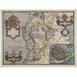
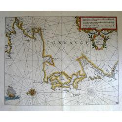
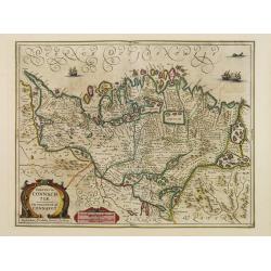
The province of Connaugh with the Citie of Galwaye Described.
A most decorative map of the Irish province of Connaught. The sea is decorated with ships and sea monsters, including one being ridden by an Irish bard playing a harp. On...
Place & Date: London, 1610 - 1616
Selling price: $500
Sold in 2013
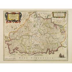
The countie of Leinster with the Citie Dublin Described.
A most decorative map of the Irish County of Leinster, which includes this remarkable early plan of Dublin, a sea monster, sailing ship and decorative compass rose. One o...
Place & Date: London, 1610 - 1616
Selling price: $500
Sold in 2013
The countie of Leinster with the Citie Dublin Described.
A most decorative map of the Irish County of Leinster, which includes this remarkable early plan of Dublin, a sea monster, sailing ship and decorative compass rose. One o...
Place & Date: London, 1610 - 1616
Selling price: $750
Sold in 2015
The province of Connaugh with the Citie of Galwaye Described.
A most decorative map of the Irish province of Connaught. The sea is decorated with ships and sea monsters, including one being ridden by an Irish bard playing a harp. On...
Place & Date: London, 1610 - 1616
Selling price: $650
Sold in 2015
De West-Cust van Yerlandt tusschen C. Tellin en Slijnehooft.
Vry rare sea chart from Willem Blaeu's maritime atlas "Derde Deel der Zeespiegel."
Place & Date: Amsterdam, c. 1623
Selling price: $365
Sold in 2010
Irlandiae Regnum.
A very nice map from Ireland, made of 2 maps pasted together.Mercator was born in Rupelmonde in Flanders and studied in Louvain under Gemma Frisius, Dutch writer, astrono...
Place & Date: Amsterdam 1630
Selling price: $500
Sold
Udrone Irlandiae in Catherlagh Baronia.
Depicts present day County Carlow in Leinster Province and Catherlaugh which is now Carlow.The title is surrounded by a strapwork design cartouche topped with calipers &a...
Place & Date: Amsterdam, 1630
Selling price: $200
Sold
Udrone Irlandiae in Catherlagh Baronia.
Depicts present day County Carlow in Leinster Province and Catherlaugh which is now Carlow.The title is surrounded by a strapwork design cartouche topped with calipers &a...
Place & Date: Amsterdam, 1630
Selling price: $80
Sold in 2011
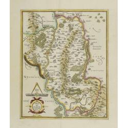
Ultoniae Orientalis Pars.
Early map featuring the Down & Antirm counties of Northern Ireland. Interesting, decorative combination title / scale cartouche and the sea is in moire pattern. Frenc...
Place & Date: Amsterdam, 1633
Selling price: $170
Sold in 2015
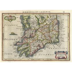
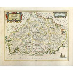
Momonia et Lagenia.
Nice map of the Southern part of Ireland. Decorated with a small strapwork title cartouche and a monster in the Ocean. Latin text on verso.
Place & Date: Amsterdam 1634
Selling price: $80
Sold
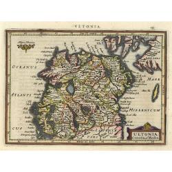
Ultonia, Conatia et Media.
This small map provides a detailed view of Northern Ireland and includes a handsome title cartouche. Latin text on verso.
Place & Date: Amsterdam 1634
Selling price: $100
Sold
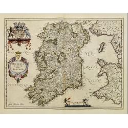
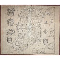
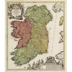
Hibernia regnum vulgo Ireland..
Standard map of Ireland embellished with decorative coat of arms, cartouche with title and a scale cartouche showing two putti.
Place & Date: Amsterdam, 1635
Selling price: $700
Sold
Viri Clarissimi Britannia..
A very attractive and decorative early 17th century map of Ireland which appeared in William Camden's Britannia. Based on Mercator's map of 1595, it was engraved by Willi...
Place & Date: London, W.Hole, ca. 1637
Selling price: $350
Sold in 2015
Provincia Ultoniae The Province of Ulster.
A finely engraved map of Ulster in northern Ireland. Adorned with vessels and a decorative title cartouche. Relief shown pictorially. Illustrated topography shows towns, ...
Place & Date: Amsterdam, 1638
Selling price: $47
Sold in 2017
Irlandiae Mari Portus.
Sea chart of Ireland, from Werdenhagen J., De Rebus Publicis Hanseaticis Tractatus.
Place & Date: Frankfurt, 1641
Selling price: $180
Sold in 2009
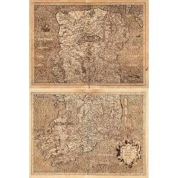
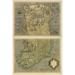
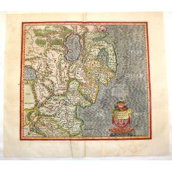
![[Two maps] Hiberniae pars Australis. . .](/uploads/cache/08341-250x250.jpg)
[Two maps] Hiberniae pars Australis. . .
Fine two sheet map of Ireland, with impressive topographical information, with several keys. Prepared by Mercator, published by Janssonius / Hondius.Mercator's two-sheet ...
Place & Date: Amsterdam, 1642
Selling price: $600
Sold in 2019
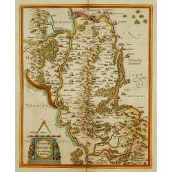
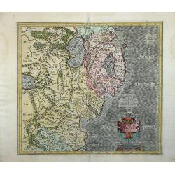
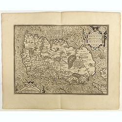
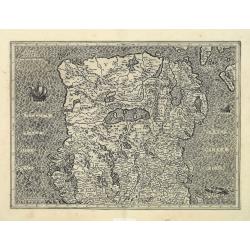
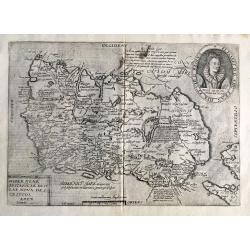
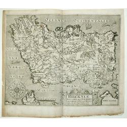
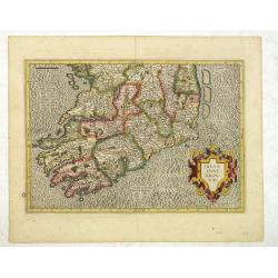
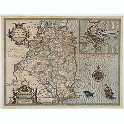
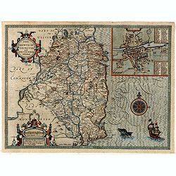
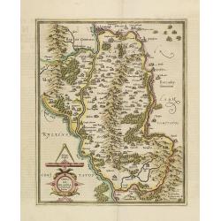
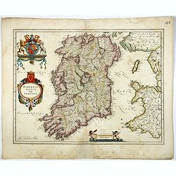
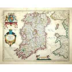
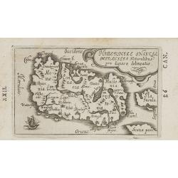
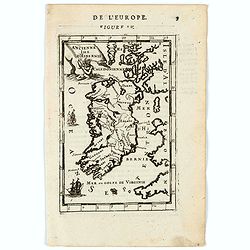
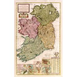
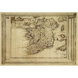
Ultoniae orientatlis pars.
Showing Northern Ireland with Lough Neagh and Belfast. Signed lower right hand corner Sumptibus Henrici Hondy.Henricus Hondius re-issued Mercator's map with a new title c...
Place & Date: Amsterdam 1639-1644
Selling price: $150
Sold
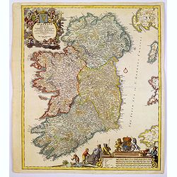
Two maps: Hiberniae pars Australis/..
Fine map of Ireland in two parts. Prepared by Mercator, published by Henricus Hondius. Mercator's name erased.
Place & Date: Amsterdam 1639-1644
Selling price: $400
Sold
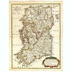
Comitatus Lageniae. The Countie of Leinster.
Finely engraved map of the eastern part of Ireland. Orientated with the West on top. Decorated with vessels, title cartouche and scale of miles cartouche. Relief shown pi...
Place & Date: Amsterdam 1645
Selling price: $310
Sold
Provincia Momoniae. The province of Mounster.
Fine map of southern part of Ireland. Adorned with vessels, sea monsters, a compass rose and two very decorative cartouches.
Place & Date: Amsterdam 1645
Selling price: $425
Sold
Provincia Ultoniae. The province of Ulster.
Finely engraved map of Ulster. Adorned with vessels and a decorative title cartouche. Relief shown pictorially. Illustrated topography shows towns, river systems and indi...
Place & Date: Amsterdam 1645
Selling price: $200
Sold
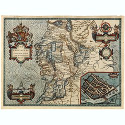
Provincia Connachtiae. The province of Connaught.
Finely engraved map of the north-western part of Ireland. Adorned with vessels, sea monsters and two very decorative cartouches. Relief shown pictorially. Illustrated top...
Place & Date: Amsterdam 1645
Selling price: $255
Sold
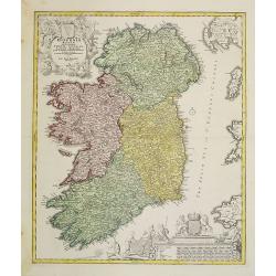
Hibernia regnum vulgo Ireland.
Standard map of Ireland embellished with decorative coat of arms, cartouche with title and a scale cartouche showing two putti. The map is heavily based on an earlier map...
Place & Date: Amsterdam, 1645
Selling price: $200
Sold in 2017
Irlandia.
Detailed miniature map of Ireland, from a German text edition of his Atlas Minor. Engraved by Petrus Kaerius.
Place & Date: Amsterdam (1628) 1648
Selling price: $190
Sold
Provincia Momoniae.
Detailed miniature map of the southwestern most tip of Ireland, including the counties of Tipperary, Waterford, Limerick, Cork and Kerry. From a German text edition of hi...
Place & Date: Amsterdam (1628) 1648
Selling price: $95
Sold
Hibernia regnum vulgo Ireland
A good and dark impression of a cornerstone map of Ireland, with three decorative cartouches in full original color.
Place & Date: Amsterdam, 1650
Selling price: $600
Sold
Lagenia; Anglis Leinster / The countie of Leinster.
An elegant map which includes the area westward from Dublin to the Shannon and from Waterford in the north to Drogheda. A decorative map with galleons in full sail in the...
Place & Date: Amsterdam, 1654
Selling price: $400
Sold in 2018
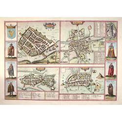
Galwaye, Dubline , Lymericke, and Corcke - Braun & Hogenberg, 1618.
Fine "carte à figures"- map with four Irish bird's-eye plans: Galway, Dublin, Limerick and Cork with left and right borders of costumed figures and top right v...
Place & Date: Amsterdam, (1618) 1657
Selling price: $1450
Sold in 2013
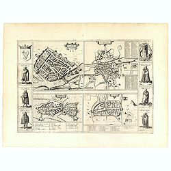
Galwaye, Dubline , Lymericke, and Corcke.
Four early town plans with six costume vignettes, the Irish crest and a view of Enniskillen Castle down the sides, published in the 'Civitates Orbis Terrarum'. All the il...
Place & Date: Amsterdam, 1657
Selling price: $850
Sold in 2019
Hiberniae Insulae miraculis naturalibus pro digiosae delineatio.
Charming little map of Ireland made by Gabriel Bucelin (1599-1681). Bucelin was a Swiss genealogist and an author of several books and a number of manuscript maps of Germ...
Place & Date: Ulm, Johannes Görlin, 1658-1664
Selling price: $162
Sold in 2008
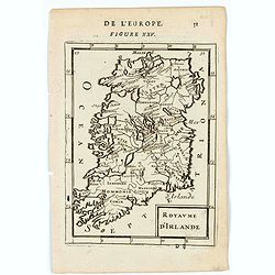
Irlande Royaume divisé en ses quatre provinces..
Covering Ireland. Nicolas Sanson was to bring about the rise of French cartography, although the fierce competition of the Dutch would last until the end of the century. ...
Place & Date: Paris 1665
Selling price: $150
Sold
De Noordwest zyde van Yerlandt Beginnende van Capo de Hoorn; tot aen Schynes of Slyynhead . . .
A large, rare chart of part of the northwest coast of Ireland, including Achill Island, Donegal and Sligo.Originally produced by Theunisz Jacobsz for his Lichtende Colomn...
Place & Date: Amsterdam, 1666
Selling price: $390
Sold in 2019
A Mapp of the Kingdome of Ireland.
From 'Britannia', first published in 1673. The map is based on John Speed's map. The map has five Coats of Arms. In this much rarer edition Boyle's Coat of Arms at the to...
Place & Date: London, 1673
Selling price: $300
Sold in 2018
Royaume d'Irlande.
A charming miniature map of Ireland Title in curtain draped at top. French text on verso.From the original 1683 text edition of "Description d'Univers. . ." by ...
Place & Date: Paris, 1683
Selling price: $30
Sold in 2022
Ancienne Isle d'Hibernie.
A charming map of ancient Ireland. Title in curtain draped at top. French text on verso.From the original 1683 text edition of "Description d'Univers. . ." by A...
Place & Date: Paris, 1683
Selling price: $30
Sold in 2020
Isle d'Irlande.
A charming late 17th century French map of Ireland, by Allain Manneson Mallet (1630-1706), a well travelled military engineer and geographer who worked in 17th century Fr...
Place & Date: Franckfurt 1684
Selling price: $60
Sold
L'Irlande suiant les dernieres relations..
Rare miniature map of Ireland by N. de Fer, dated 1689.
Place & Date: Paris 1689
Selling price: $140
Sold
L\'Irlanda o uero Hibernia...
Giacomo Rossi's fine late 17th century map of Ireland. Issued in Il Mercurio geografico In lower right a tittle cartouche.The cartographer was Giacomo Cantelli da Vignola...
Place & Date: Rome, 1689
Selling price: $210
Sold in 2015
Isle et Royaume d'Irlande..
"Detailed map of Ireland, including also a list of all the counties and main towns and their location. With the address "" A Paris chez le Sr. N. De Fer, d...
Place & Date: Paris 1690
Selling price: $560
Sold
Le Royaume d'Irlande ...
Uncommon map of Ireland. A visually stunning map with a large title cartouche. This large one-sheet map was produced by the Venetian cosmographer Vincenzo Coronelli when ...
Place & Date: Paris, 1690
Selling price: $350
Sold in 2013
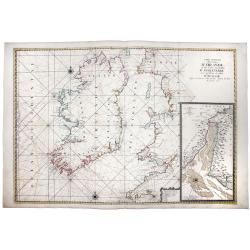
Carte Generale des Costes D'IRLANDE, et des Costes Occidentales D' ANGLETERRE avec une Partie de celles D' ECOSSE.
A magnificent chart of Ireland and the British Coast from Plymouth in Cornwall to Ayr in Scotland. A detailed inset chart of the River Dee as far as Holt is included in t...
Place & Date: Paris, 1693
Selling price: $600
Sold in 2019
![[Two maps] Parte settentrionale dell' Irlanda descritta.. / Irlanda Parte Meridionale..](/uploads/cache/23418-250x250.jpg)
[Two maps] Parte settentrionale dell' Irlanda descritta.. / Irlanda Parte Meridionale..
A two sheet map of Ireland. The remarkable Vincenzo Coronelli (1650-1718), encyclopaedist, geographer, inventor and Doctor of Theology, was citizen of the Republic of Ven...
Place & Date: Venice 1695
Selling price: $1550
Sold
![[2 sheets] Parte Settentrionale del' IRLANDA... [with] IRLANDA Parte Meridionale. . .](/uploads/cache/83234-250x250.jpg)
[2 sheets] Parte Settentrionale del' IRLANDA... [with] IRLANDA Parte Meridionale. . .
A matching set in contemporary Italian original color (contemporary colored maps of Coronelli are very rare on the market) of 2 attractive large folio maps depicting the ...
Place & Date: Venice, 1696
Selling price: $950
Sold in 2019
L''irelande suivant les nouvelles observations
A beautifully rendered and sought after map of Ireland. The cartouche depicts a pastoral scene with horsemen, hunters and various domesticated and wild animals. A very de...
Place & Date: Leiden, ca. 1700
Selling price: $550
Sold in 2008
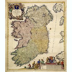
A new map of Ireland devided into its provinces..
A good copy of this very decorative and detailed large scale map. 12 inset plans of the towns of Dublin, Cork, Kinsale, Limerick, Waterford and Galway, and of the Giants'...
Place & Date: London 1714
Selling price: $1100
Sold
Hiberniae regnum. . .
A detailed and decorative map of Ireland, colored by the 4 regions and showing the towns, roads, counties, rivers, lakes, castles, etc. Includes a pair of lovely cartouch...
Place & Date: Nurnberg, 1715
Selling price: $300
Sold in 2017
Nieuwe pascaert, vande suyt syde van Yrlandt..
Showing the south coast of Ireland.Latitude scale, compass rose and system of rhumb lines, soundings, anchorage's, etc. In lower right corner with added number 20.
Place & Date: Amsterdam 1720
Selling price: $625
Sold
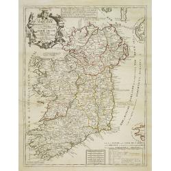
Nouvelle carte de l'Irlande, où on remarque l'Etat présente de cette isle . . .
Finely engraved map of Ireland, with two smaller maps of Ireland showing Ancient Ireland and an ecclesiastical map of modern Ireland. From Chatelain's monumental 7 volume...
Place & Date: Amsterdam, 1720
Selling price: $100
Sold in 2017
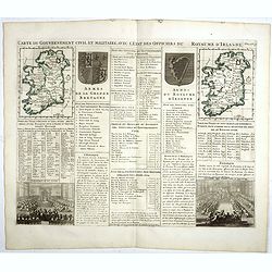
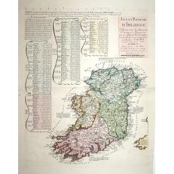
Carte du gouvernement civil et militaire avec l'Etat des Officiers du Royaume d'Irlande . . .
Engraved text sheet with two maps of Ireland (140 x 105mm. each), coats of arms of Ireland and England and a views of Irish Parliament and the House of Commons.Henri Abra...
Place & Date: Amsterdam, 1720
Selling price: $40
Sold in 2022
L'Irlande, suivant les nouvelles observations..
Fine map of Ire land, with decorative title cartouche lower left corner.This example is unusual in having the additional separately engraved decorative framework border a...
Place & Date: Amsterdam, 1728
Selling price: $300
Sold in 2015
Hiberniae regnum..
A detailed and decorative map of Ireland, with an attractive uncolored title cartouche.
Place & Date: Nurnberg 1730
Selling price: $550
Sold
Hiberniae regnum. . .
A detailed and decorative map of Ireland, with an attractive uncolored title cartouche.
Place & Date: Nurnberg 1730
Selling price: $450
Sold in 2010
Hiberniae regnum. . .
A detailed and decorative map of Ireland, with an attractive uncolored title cartouche.
Place & Date: Nurnberg 1730
Selling price: $105
Sold in 2012