Browse Listings in Europe > British Isles > British Isles Cities
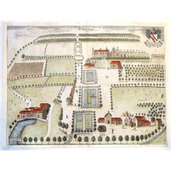
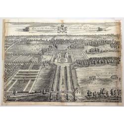
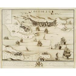
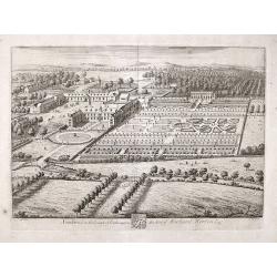
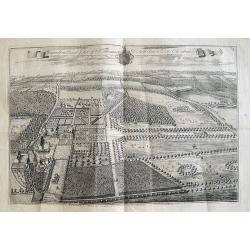
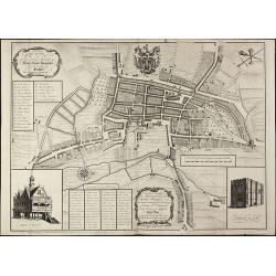
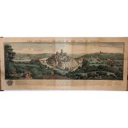
The East & West Prospect of Bushey Hall.
A very detailed plan of Bushey Hall with even the people quite detailed. It was published by Sir Henry Chauncy in "HISTORICAL ANTIQUITIES OF HERTFORDSHIRE" in 1...
Date: London, 1700
Selling price: ????
Please login to see price!
Sold in 2019
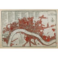
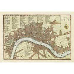
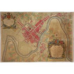
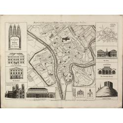
Plan des Villes de Londres et de Westminster et de leurs Faubourgs avec le Bourg de Southwark.
A rare engraving of London at the turn of the 17th/18th centuries engraved by C Inselin, stretching from Westminster Abbey in the west to Mile End in the east. A 113 poin...
Date: Paris, 1705
Selling price: ????
Please login to see price!
Sold in 2011
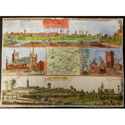
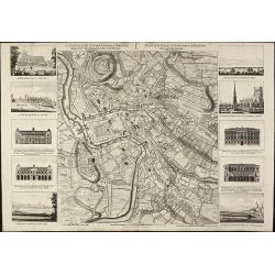
Vues des villes de Londres, de Canterbury, de Colchester, et autres Lieux circonvoisins. - II. ... Vues des villes, edifices & autres choses remarquable de l'Escosse & d'Irlande. - III. and IV
Four books in one, printed Chez Pierre vander Aa, Leyden, Netherlands.  Beautiful, very rare plate book of Great Britain in 6 parts with a total of 25 maps, and 216 pla...
Date: Leyden, 1707
Selling price: ????
Please login to see price!
Sold in 2023
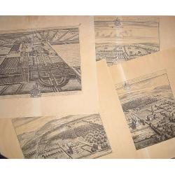
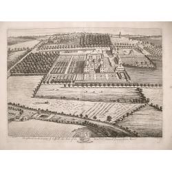
16 plates of English castles and houses.
16 very finely engraved and detailed bird's-eye views of the great English country houses, showing the architecture, formal gardens, and the surrounding landscape.The pla...
Date: London, 1708
Selling price: ????
Please login to see price!
Sold
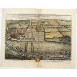
Swillington in the West Rideing of Yorkshire, the Seate of William Louther, Esq.
Fine hand-colored bird's-eye view of the great country house of Swillington. It shows the architecture, formal gardens, and the surrounding landscape. Drawn by Leonard Kn...
Date: London, 1708
Selling price: ????
Please login to see price!
Sold in 2019
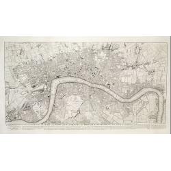
A Plan of London, Westmr. and Southwark wth ye Rivr Thames...
Hatton's famous edition of Braun & Hogenberg's view of London, first published in 1572. Shows the city in a detailed birds-eye perspective. Numerous buildings, roads,...
Date: London, 1708
Selling price: ????
Please login to see price!
Sold in 2016
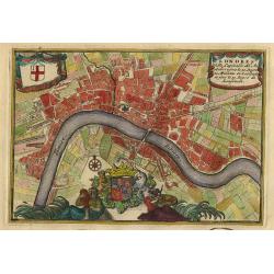
Londres.
Nice little plan of London, with 3 cartouches with coat of arms.
Date: Amsterdam 1710
Selling price: ????
Please login to see price!
Sold
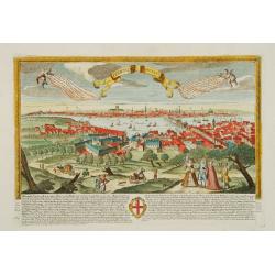
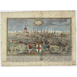
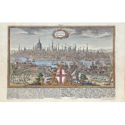
Londinum - London
A rare and beautifully engraved and richly detailed panoramic view of London. With in lower part description of London in German and Latin. Published by Joseph Friederich...
Date: Augsburg 1711
Selling price: ????
Please login to see price!
Sold
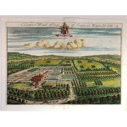
Clower-Wall the Seat of Francis Wyndham, Esq.
A large, fine, copper engraved print illustrating a birds-eye view of Clower-Wall, the Seat of Francis Wyndham, Esq.Published in 1712 for Robert Atkyns. Drawn and engrave...
Date: London, 1712
Selling price: ????
Please login to see price!
Sold in 2019
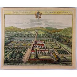
Coberly the Seat of Jonathan Castelman Esq.
A fine, large, detailed birds-eye view of Coberly by Kip, who produced the engravings for the remarkable "The Ancient & Present State of Gloucestershire", p...
Date: London, 1712
Selling price: ????
Please login to see price!
Sold in 2023
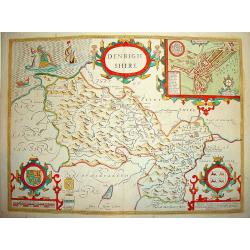
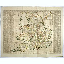
Denbighshire.
Highly decorative map of the county of Denbighshire, located in the northwest corner of Wales. The upper right corner inset contains a plan of the town of Denbigh, along ...
Date: London 1713
Selling price: ????
Please login to see price!
Sold
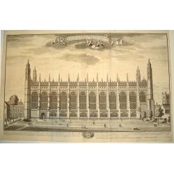
COLLEGII REGALIS APUD CANTABRIGIENSES SACELLUM / KINGS COLLEGE CHAPPEL IN CAMBRIDGE
A large, superb profile of the famous Kings College Chapel of Cambridge University, as seen in the very early years of the 18th century. The title of the view is shown in...
Date: London, c. 1715
Selling price: ????
Please login to see price!
Sold
The prospects of the two most remarkable towns in the north of England for the clothing trade, viz. Leeds, As it appears from Holbeck Road, and Wakefield, As it appears from London Road.
This plate was published in Ducatus Leodiensis, or the Topography of the Town and Parish of Leedesby the Yorkshire antiquary Ralph Thoresby.Thoresby continued his fatherâ...
Date: London, 1715
Selling price: ????
Please login to see price!
Sold in 2017
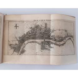
Plan des villes de Londres et de Westminster et de leurs Faubourgs avec le bourg de Southwark. . .
Plan of London engraved by C Inselin, stretching from Westminster Abbey in the west to Mile End in the east. A 113 point key identifies important landmarks.This is the ra...
Date: Paris, 1717
Selling price: ????
Please login to see price!
Sold in 2011
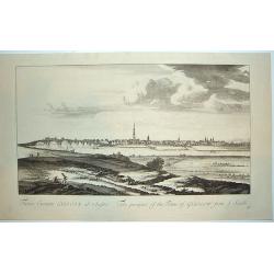
Facies Civitalis GLASCOAE...The prospect of the Town of Glasgow from the South
A beautifully engraved view of Glasgow, Scotland from a southern approach. Glasgow is dominated in the center by its cathedral. From the THEATRUM SCOTIAE, an important re...
Date: ca. 1719
Selling price: ????
Please login to see price!
Sold in 2011
The Mote, One of the Seats of Ye Right Honorable the Lord Romney.
A fine detailed bird's eye view of 'The Mote', showing the house, gardens and the avenues of trees stretching out into the surrounding park. Title along top edge, coat of...
Date: London, 1719
Selling price: ????
Please login to see price!
Sold in 2018
Portsmouth.
A very fine and quite large view of Portsmouth from Joannes Kip's Britannia Illustrata or Views of Several of the Queens Palaces also of the Principal Seats of the Nobili...
Date: London 1708-1720
Selling price: ????
Please login to see price!
Sold
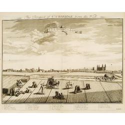
Prospect of Cambridge from the west.
A very fine and quite large view of Cambridge seen from the west, from: Britannia Illustrata or Views of Several of the Queens Palaces also of the Principal Seats of the ...
Date: London 1708-1720
Selling price: ????
Please login to see price!
Sold
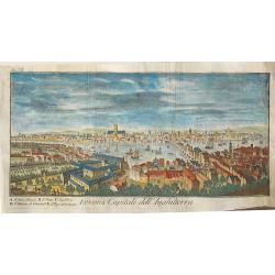
Londres capitale de l'Angleterre.
Fine and uncommon panoramic view of London. The view is printed within a large, elaborately engraved mock-frame border, which was prepared with a blank centre so that the...
Date: Leiden 1720
Selling price: ????
Please login to see price!
Sold
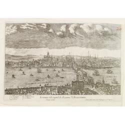
Londres Ville Capitale du Royaume d'Angleterre.
A very RARE panoramic view of the city of London, with a numbered legend in lower left corner.The plate is numbered in red pencil in upper right corner.Engraved by Jean C...
Date: Paris 1690-1720
Selling price: ????
Please login to see price!
Sold
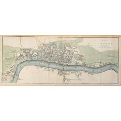
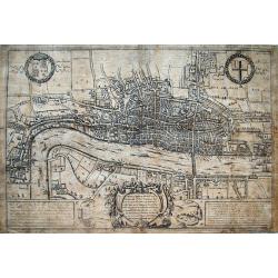
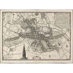
Plan of London in the reign of Queen Elizabeth.
Plan of London in the reign of Queen Elizabeth 1st 1546. This delicately hand colored early map of London is highly detailed. This map dated 1720 by James Stratford of Ho...
Date: London, 1720
Selling price: ????
Please login to see price!
Sold in 2014
Southwick in the County of Southampton Seat of Richard Norton Esq.
Engraved by Joannes Kip after the drawing by Leonard Knyff. Plate 74 from "Britannia Illustrata or Views of Several of the Queens Palaces and also of the Principal S...
Date: London, 1720
Selling price: ????
Please login to see price!
Sold in 2017
Brightwel in the County of Suffolk the seat of the Honourable Sir Barnardiston Barr.
Brightwel in the County of Suffolk the seat of the Honourable Sir Barnardiston Barr. Plate 52 from "Britannia Illustrata or Views of Several of the Queens Palaces...
Date: London, 1720
Selling price: ????
Please login to see price!
Sold in 2017
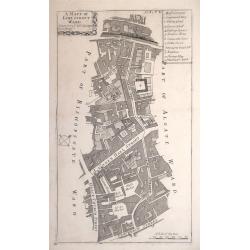
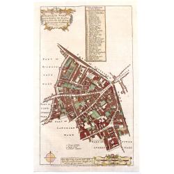
A MAPP OF LIME STREET WARD. TAKEN FROM YE LAST SURVEYS & CORRECTED.
An eighteenth-century plan of Lime Street Ward in the heart of the City of London. The area covered extends north from Fenchurch Street across Leadenhall Street and via S...
Date: London, 1720
Selling price: ????
Please login to see price!
Sold in 2014
![[London to Portsmouth by John Owen & Emanuel Bowen.]](/uploads/cache/97413-250x250.jpg)
[London to Portsmouth by John Owen & Emanuel Bowen.]
Two conjoined strip road maps page numbers 72 & 73 from “Britannia Depicta or Ogilby Improved.” A pocket road atlas by John Owen and Emanuel Bowen. Together these...
Date: London, 1720
Selling price: ????
Please login to see price!
Sold in 2016
Nouvelle Carte de l'Alemagne avec des tables des branches de la noblesse..
Map of England including parts of the neighbouring countries with a key table to the towns on both sides.Zacharie Chatelain (d.1723) was the father of Henri Abraham (1684...
Date: Amsterdam, ca. 1720
Selling price: ????
Please login to see price!
Sold in 2017
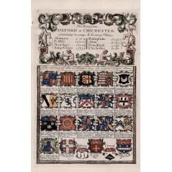
'Arms of the Colleges &c. in Cambridge' - The route from Oxford to Chichester.
A decorative antique strip map of the route from Oxford to Chichester.The route follows Oxford to Abingdon to East Istley to Newbury to King's Cleer.The 'Arms of the Coll...
Date: London, 1720
Selling price: ????
Please login to see price!
Sold in 2018
Knowlton Court ye Seat of Sr Thomas D'Aeth Bart & Dame Elizabeth his Wife.
A large copper engraved plan of the manor house. The view is highly detailed, showing buildings, horses, deer, parks, roads, and sailing ships in the background. Below a ...
Date: London, ca 1720
Selling price: ????
Please login to see price!
Sold in 2018
Ichnographia Burgi perantiqui Lennae regis in Agro Norfolciensi accurate delineata Ano MDCCXXV.
Important and very rare plan of King's LynnA large and detailed copper engraved plan of King's Lynn Harbour in Norfolk, drawn and published by Gulielmus Rastrick in 1725....
Date: London, 1725
Selling price: ????
Please login to see price!
Sold in 2010
Londen.
Rare map of London with a legend in margins from: Force d'Europe, oder die Merckwürdigst– und Fürnehmste, meistentheils auch Ihrer Fortification wegen Berühmteste St...
Date: Augsburg, 1728
Selling price: ????
Please login to see price!
Sold in 2015
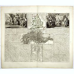
Nouvelle carte du gouvernement civil D'Angleterre et de celuy de la ville de Londres.
Striking plan of London, with map of England and two large allegorical figures of Liberty, Justice, Tranquility Rest and Patriotism to the left vignette and Commerce and ...
Date: Amsterdam, 1728
Selling price: ????
Please login to see price!
Sold in 2018
Londini Angliae regni metropolis delineatio accuratissima ..
A beautifully engraved and richly detailed plan of London. In upper right part a key to 148 principal spots in the town. From Galerie Agréable du Monde, a sixty-six volu...
Date: Leiden 1729
Selling price: ????
Please login to see price!
Sold
![Collegium Reginense - Queen's College. [Oxford]](/uploads/cache/43162-250x250.jpg)
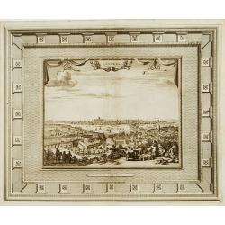
Collegium Reginense - Queen's College. [Oxford]
A lovely double page, folio copper engraved print of Queen's College, Oxford by William Williams (fl.1724-1733). Originally published in:- Oxonia Depicta sive Collegiorum...
Date: Oxford, ca 1730
Selling price: ????
Please login to see price!
Sold in 2020
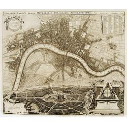
Urbium Londini et West-Monasterii nec non Surburbii Southwark Accurata Ichnographia ... Neuester Grundris der Staedte London und West-Munster, Samt der Vorstadt Southwark ...
Detailed plan of London. Ornamental title cartouche surmounted by the royal arms of George II, with a note in Latin and German within semi-elliptical banner, glossary of ...
Date: Nuremberg, 1736
Selling price: ????
Please login to see price!
Sold in 2017
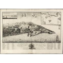
The Citadel of Plymouth.
Rare view of the Citadel of PlymouthA large and impressive copper engraved view of the Citadel of Plymouth, draw by Sandford Mace and engraved by Charles Mosley. Shows th...
Date: London, dated July 25th, July 1737
Selling price: ????
Please login to see price!
Sold in 2010
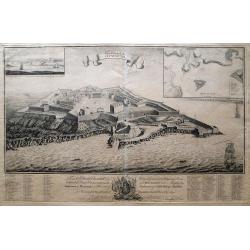
The Citadel Of Plymouth.
A magnificent panoramic view of the citadel at Plymouth which was built in 1665. The view is dedicated to the "Hon. Charles Churchill Esqr. Major General Of His Maje...
Date: London, 1737
Selling price: ????
Please login to see price!
Sold in 2014
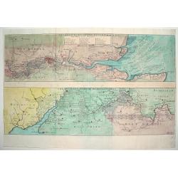
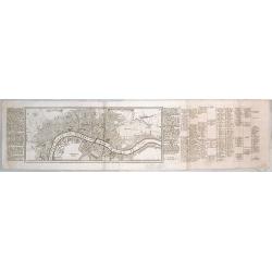
THE EAST PART OF THE RIVER THAMES / THE WEST PART OF THE RIVER THAMES
An attractive and detailed map of the River Thames. The top portion of the work focuses on the eastern end of the river, highlighting London and directly west. The lower ...
Date: London, ca. 1738
Selling price: ????
Please login to see price!
Sold
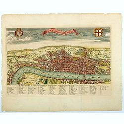
A View of London about the Year 1560.
Published as the frontispiece to Maitland's well recognized HISTORY OF LONDON, this is a sought after, handsome and finely engraved bird's-eye view / plan of Elizabethan ...
Date: London, ca 1738
Selling price: ????
Please login to see price!
Sold in 2021
LONDINUM Konden.
A rare and decorative city view of London, England, an engraving after F.B. Werner by J.G. Ringlin published in the “Europäische Städteansichten”, made by Martin En...
Date: Augsburg, ca 1740
Selling price: ????
Please login to see price!
Sold in 2021
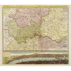
Regionis, quae est circa Londinum ..
Detailed map of greater area of London. At bottom an panoramic view (116x569mm). A most decorative item.
Date: Nuremberg 1741
Selling price: ????
Please login to see price!
Sold
A New and Accurate Plan of the Ancient Borough of Bury Saint Edmunds in the Country of Suffolk By Alexander Downing. 1740
Important and very rare plan of Bury St. Edmunds by A. DowningA large and detailed copper engraved plan of Bury St. Edmunds, Suffolk, drawn and published by Alexander Dow...
Date: London, 1741
Selling price: ????
Please login to see price!
Sold in 2010
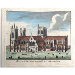
Facciata della Chiesa Cattedrale di S. Pietro in Jorck.
Facade of the Cathedral Church of St. Peter in York. Hand colored copper engraving published by York in 1743 and engraved by Salmon.
Date: Gavirate, 1743
Selling price: ????
Please login to see price!
Sold in 2018
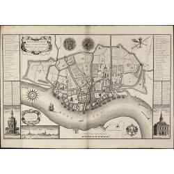
Plan of the city & Castle of Chester, Survey'd and Drawn by Alexander de Lavaux.
A rare and important plan of the city of Chester was engraved by Parr but surveyed and drawn by a Dutch engineer, Alexandre De Lavaux. Two large and imposing cartouches c...
Date: London, 1745
Selling price: ????
Please login to see price!
Sold in 2017
The Southwest Prospect of the City of Durham.
A delightful copperplate engraving of the city of Durham, published in 1745 in London by Samuel and Nathaniel Buck. It shows the ancient city perched high on a hill, over...
Date: London, 1745
Selling price: ????
Please login to see price!
Sold in 2017
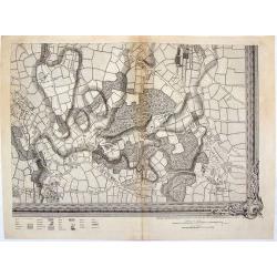
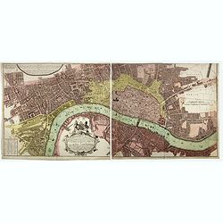
A Map of London and the Adjacent Country 10 Miles Around - (Sheet 1 of 16).
This is a part of an exact Survey of the City of London Westminster, ye Borough of Southwark and the country near ten miles round, begun in 1741 and ended in 1745, by Joh...
Date: London, 1746
Selling price: ????
Please login to see price!
Sold in 2020
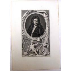
Sir Richard Steele.
This ia a large finely engraved portrait of Sir Richard Steele, the private secretary to James. the 1st Duke of Ormonde. It was engraved by Houbraken from a painting by K...
Date: Amsterdam, 1748
Selling price: ????
Please login to see price!
Sold in 2016
![[2 prints] The inside perspective view of the under Chappel... / A view of the west front of the Chappel...](/uploads/cache/82580-250x250.jpg)
[2 prints] The inside perspective view of the under Chappel... / A view of the west front of the Chappel...
Two quite rare attractive copper-engravings of the St. Thomas Chapel on the old London Bridge. Engraved by James Basire, drawn by George Vertue, published in the first vo...
Date: London, 1748
Selling price: ????
Please login to see price!
Sold in 2019
This plan of the cities of London and Westminster and Borough of Southwark, with the contiguous buildings..
First state of this detailed and important plan of London, engraved by Isaac Basire. With a dedication to Martin Folkes.
Date: London, 1749
Selling price: ????
Please login to see price!
Sold
![To Martin Folkes Esq[ui]r[e] President of the Royal Society: This Plan of the Cities of London with the Contiguous Buildings. . .](/uploads/cache/83535-250x250.jpg)
To Martin Folkes Esq[ui]r[e] President of the Royal Society: This Plan of the Cities of London with the Contiguous Buildings. . .
A plan of London, Westminster and Southwark published in London in 1749. The text below the plan states that the map was taken from Rocque’s great survey of the city, t...
Date: London, 1749
Selling price: ????
Please login to see price!
Sold in 2020
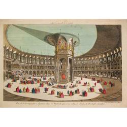
Vue de la Compagnie a déjeuner dans la Rotonde qui est au milieu des Jardins de Renelagh a Londres.
An optical view of a meal held in the Rotonde in Renelagh park in London.
Date: Paris, c. 1750
Selling price: ????
Please login to see price!
Sold in 2020
Vue Perspective...Ville de Londres prise de la Temise
A "vue optique" view of London on the River Thames. Major monuments are depicted, including the Tower of London, St. James and Westminster Bridge. Numerous mari...
Date: Paris, ca. 1750
Selling price: ????
Please login to see price!
Sold in 2010
A Plan of the City of Coventry Surveyed in MDCCXLVIII & IX by Samuel Bradford and Engraved by Thos. Jefferys
Rare and important plan of Coventry by T. Jefferys.A large and detailed plan of Coventry, engraved and published by Thomas Jefferys in 1750 after a survey of Samuel Bradf...
Date: London, 1750
Selling price: ????
Please login to see price!
Sold in 2010
A Plan of the City of York Survey'd By Peter Chassereau / Plan de la Ville et foubourgs de York. Capitale de le Comté du meme Nom levé par le Sr. P: Chassereau & Publié par Rocque a Charing Cross 1750
Rare plan of York by J. RocqueA large and detailed copper engraved plan of York, published by John Rocque in 1750 after a survey of Peter Chassereau. Surrounded by 10 ins...
Date: London, 1750
Selling price: ????
Please login to see price!
Sold in 2010
A Survey of the City and Suburbs of Bristol Survey'd by John Rocque Land Surveyor at Charing Cross, 1750 / Plan de la Ville et Faubourgs de Bristol Leve par Jean Rocque a Charing Cross a Londres 1750
Rare map of Bristol by J. RocqueA large and detailed copper engraved map of the city and suburbs of Bristol, draw, serveyed and published by John Rocque in 1750. Surround...
Date: London, 1750
Selling price: ????
Please login to see price!
Sold in 2010
A View of the grand Palace of Westminster. / VĂĽe du Palais Episcopal de Westminster.
So-called optical print illustrating a perspective view of the old Palace of Westminster where the Lords and Commons met and the square facing it.In the eighteenth and ni...
Date: London, c.1750
Selling price: ????
Please login to see price!
Sold in 2019
A View of the Tower with the Bridge & part of the City of London from the River. Vue de la Tour du Pont et partie de la Ville de Londres prise de la Riviere.
So-called optical print illustrating part of the city of London, taken from the river Thames. With numbered key list. Engraved by Charpentier.In the eighteenth and ninete...
Date: London, c.1750
Selling price: ????
Please login to see price!
Sold in 2013
Londinum Londen.
Rare view of London, in nice hand coloring.
Date: Augsburg, 1750
Selling price: ????
Please login to see price!
Sold in 2012
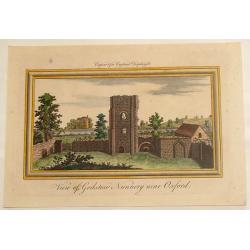
View of Godston Nunnery Near Oxford.
Pleasant hand-colored print of the famous "Godston Nunnery" close to Oxford in Oxfordshire. The print was by Samuel & Nathaniel Buck who sketched the ruins ...
Date: London, c1750
Selling price: ????
Please login to see price!
Sold in 2013
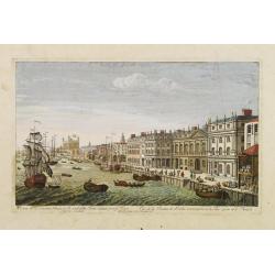
The South East prospect of London, from the Tower to London Bridge.
Optical vue of the River Thames, looking to the west from the Tower of London to London Bridge and St Paul's; animated with a number of boats on the water.
Date: Londo, circa 1750
Selling price: ????
Please login to see price!
Sold in 2022
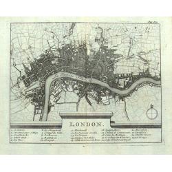
London.
Small French map of London with a key below naming 24 important places within the city. Numerous streets are indicated. Uncommon map, probably dating to around 1700-1750.
Date: Paris, ca. 1700-1750
Selling price: ????
Please login to see price!
Sold in 2016
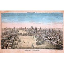
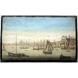
Vue generale de la ville de Londres
A 'bird's-eye' view of London, taken from a point several hundred feet above Tower Bridge. Note: St. Paul's church, the Monument to the fire of London, and Westminster Ab...
Date: Paris, ca 1750
Selling price: ????
Please login to see price!
Sold in 2016
Two Optical prints of London
Two optical prints "Prospect des Admiralitaets Hauses, nebst dem neuen Gebäu für die Quarde zu Pferd" and "Vue de la Maison de Northumberland à Charing ...
Date: Augsburg 1750
Selling price: ????
Please login to see price!
Sold in 2016
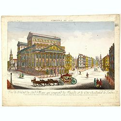
Vue de l Hotel du Lord Maire, qui comprend la Façade, et le Cot' Occidental de Londres.
Shows the famous Lord Mayor's coach driving through London. The Lord Mayor's coach is famous for its role in the Lord Mayor's Show, which is one of the longest establishe...
Date: Augsburg, 1750
Selling price: ????
Please login to see price!
Sold in 2016
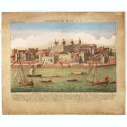
Der Tower La Tour de Londres.
Optical view by J.B. WINCKLER after L. KNYF, German and French captions below, In the eighteenth and nineteenth centuries there were many popular speciality establishment...
Date: Augsburg, 1750
Selling price: ????
Please login to see price!
Sold in 2016
Three Optical prints of London. . .
Three optical prints of London "An Inside View of the Rotundo in London Caff. - Vue interieur de la Rotonde oú le Caffé", with "A View of the Royal Palac...
Date: London, ca. 1750
Selling price: ????
Please login to see price!
Sold in 2016
Londra, capitale dell'Inghilterra
A nice copper engraving depicting the city of London, from "Lo stato presente di tutti i paesi e popoli del mondo naturale, politico, e morale", printed in 1750...
Date: Venice, ca 1750
Selling price: ????
Please login to see price!
Sold in 2016
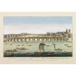
A North viewe of Westminster Bridge.
So-called optical print illustrating a North view of Westminster Bridge with vessels on the River Thames.In the eighteenth and nineteenth centuries there were many popula...
Date: London 1751
Selling price: ????
Please login to see price!
Sold
A Plan of Wolverhampton Surveyed in MDCCL By Isaac Taylor and Engraved by Thomas Jefferys Geographer to His Royal Highness the Prince of Wales
Important and rare plan of Wolverhampton by T. JefferysA large and detailed copper engraved plan of Wolverhampton, engraved and published by Thomas Jefferys in 1751 after...
Date: London, 1751
Selling price: ????
Please login to see price!
Sold in 2010
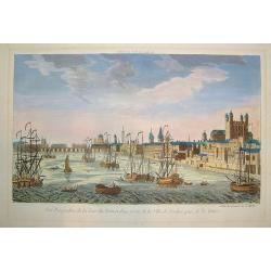
A View of the Custom House with part of the Tower taken from ye River Thames London.. Publish'd according to Act of Parliament 1753.
Very decorative, so-called optical print illustrating the river Thames with the Custom House with part of the Tower of London.In the eighteenth and nineteenth centuries t...
Date: London, 1753
Selling price: ????
Please login to see price!
Sold
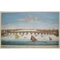
A View of Weftminfter Bridge / Vue du Pont de Weftminfter
A scarce, beautifully engraved view of Westminster Bridge and London. The work was originally executed by Boyer. Many key London sites are depicted in the background, inc...
Date: London, dated 1753
Selling price: ????
Please login to see price!
Sold in 2010
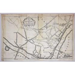
A Map of the New roads & c. from Westminster Bridge.
A detailed map of London, showing the road system south of the Thames River. The map is oriented with south at the top and extends from London Bridge, The Tower of London...
Date: London, 1753
Selling price: ????
Please login to see price!
Sold in 2019
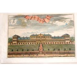
Hoxton Hospitall.
A fine 18th century copper engraving by Johannes Kip, featuring a view of Hoxton Hospital or Aske's Hospital on Pitfield Street in London. It was published according to A...
Date: London, 1754
Selling price: ????
Please login to see price!
Sold in 2015

An exact Survey of the Cities of London and Westminster, the Borough of Southwark, The Country near ten Miles round begun in 1741, finished in 1745, and publish'd in 1746. . .
Key wall-map of the greater London area surveyed by John Rocque and published in 16 sheets. One of the finest maps of – what is now – Greater London ever produced. Ac...
Date: London, 1751/1754
Selling price: ????
Please login to see price!
Sold in 2014
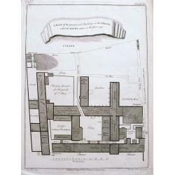
A plan of the ground and buildings in the Strand called the Savoy, taken in the year 1736.
A rare detailed plan of the Savoy between the Strand and the Thames in London. With details of each building and the business operating there. A scale bar shows distance ...
Date: London, ca 1754
Selling price: ????
Please login to see price!
Sold in 2020
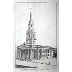
A set of 10 views of London Church's engraved by Benjamin Cole.
10 Original antique copper engravings For William Maitlands "History of London" Published in London, 1755. Titles: A PERSPECTIVE VIEW OF ST. MARTINS CHURCH....
Date: London, 1755
Selling price: ????
Please login to see price!
Sold in 2016
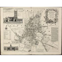
Farringdon ward without with it's division into parishes according to a new survey.
This plan was published in William Maitland's "History of London from its Foundation to the Present Time." The plan's title features in a cartouche at the top l...
Date: London, 1755
Selling price: ????
Please login to see price!
Sold in 2015
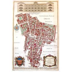
Cripplegate Ward with its Division into Parishes According to a New Survey.
A fine decorative, detailed plan of a section of London, England from John Stow's "A SURVEY OF THE CITIES OF LONDON & WESTMINSTER" published in London in 17...
Date: London, 1755
Selling price: ????
Please login to see price!
Sold in 2018
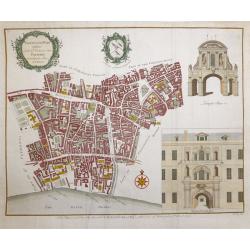
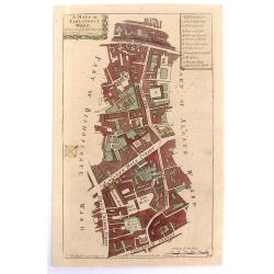
Aldgate Ward with its Division into Parishes Taken from the Latest Survey.
A fine decorative, detailed plan of a section of London, England from John Stow's "A SURVEY OF THE CITIES OF LONDON & WESTMINSTER" published in London in 17...
Date: London, 1755
Selling price: ????
Please login to see price!
Sold in 2019
A Mapp of Lime Street Ward, Taken from ye Last Surveys & Corrected.
An eighteenth-century plan of Lime Street Ward in the heart of the City of London. The area covered extends north from Fenchurch Street across Leadenhall Street and via S...
Date: London, 1755
Selling price: ????
Please login to see price!
Sold in 2019
The Prospect of Lincoln's Inn.
A pleasing picture of 'The Prospect of Lincoln's Inn' included in 'Stow's Survey of London', a fine copper engraving published in 1755. It is an fine example of the Engli...
Date: London, 1755
Selling price: ????
Please login to see price!
Sold in 2018
