Browse Listings in Europe
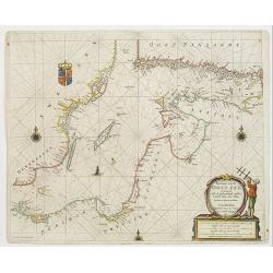
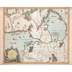
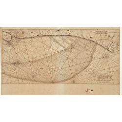
Pas-Caart van de Oost Zee verthooende alle de ghelegenheydt tusschen t Eylandt Rugen ende Wyborg. . .
An eye-catching chart of the Baltic Sea. Engraved by Gerard Coeck.Pieter Goos (ca. 1616-1675) was one of the most important cartographer, engraver, publisher and print se...
Date: Amsterdam, 1666
Selling price: ????
Please login to see price!
Sold in 2009
![Finlande septentr[iona]le et Mérid[iona]le, Nylande, et Tavasthus. . .](/uploads/cache/28355-250x250.jpg)
Finlande septentr[iona]le et Mérid[iona]le, Nylande, et Tavasthus. . .
Map of the southern part of Finland, including Helsinki, Salo, Turku, etc.
Date: Paris, Mariette, 1666
Selling price: ????
Please login to see price!
Sold in 2009
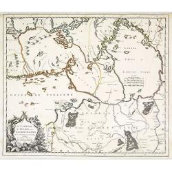
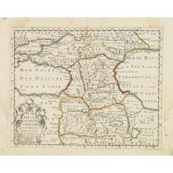
La Carelie, et l'Ingrie, ou Ingermenland. . .
Map of the gulf of Finland and Lake Ladoga and the River Neva. Interesting pre-Saint Petersburg map. The island Retusari, now known as the Kotlin Island is shown. This is...
Date: Paris, P.Mariette, 1666
Selling price: ????
Please login to see price!
Sold in 2009
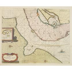
Pascaart van de Witte-Zee begrypende de custen van Laplandt, van Warsiga tot aen Kandalox en de cust van Corelia tot aen de Riviere Dwina.
A decorative chart of the White Sea, embellished with two finely colored title and scale cartouches, 2 ships and 2 compass-roses. With west to the top. In lower right cor...
Date: Amsterdam, 1666
Selling price: ????
Please login to see price!
Sold in 2010
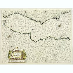
Pascaert van de mont van de Witte Zee tot aende Rivier Dwina al Archan : gel toe.
Three charts on one sheet. A decorative chart of the connection between the White Sea and the Barents Sea, embellished a finely colored title-cartouches, a ship and 2 com...
Date: Amsterdam, 1666
Selling price: ????
Please login to see price!
Sold in 2010
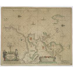
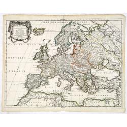
Pascaart van Europa alsmede een gedeelte vande Kust van Africa. . .
An eye-catching chart of the entirety of Europe's coastline from northern Russia to Yugoslavia in the south. Also showing the West Coast of Africa as far as the Cape-Verd...
Date: Amsterdam, after 1666
Selling price: ????
Please login to see price!
Sold in 2011
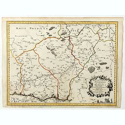
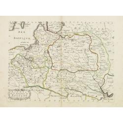
Partie de Lithuanie ou sont en partie les Palatinats de Minsk, et Mseislaw, we les Seign.Ries ou Terres de Rohaczow, Rzeczica, Zernobee, et partie des. . .
Fine map of Lithuania. This edition carries the date 1665 and the publishers address "A Paris, chez l'Autheur". Nicolas Sanson was to bring about the rise of Fr...
Date: Paris, 1666
Selling price: ????
Please login to see price!
Sold in 2011
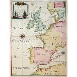
L'Ocean Pres D'Europe Avec Les Costes De France, d'Espagne, de Portugal, d'Angleterre, de Holande, De Danemarc Etc. Suivant Les Costes Marines Les Plus Nouvelles. Par. P. Du Val, Geogr.du Roy. 1666.
Attractive chart by Pierre Du Val shows the North Atlantic Ocean & the coast of Europe from Scandinavia & Great Britain down to France, Spain, the Mediterranean &...
Date: Paris, 1666
Selling price: ????
Please login to see price!
Sold in 2011
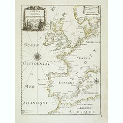
L'Ocean près d'Europe avec les Costes de France, d'Espagne, de Portugal, d'Angleterre, de Hollande, de Danemarc, & cie . . .
Attractive chart by Pierre Du Val shows the North Atlantic Ocean and the coast of Europe from Scandinavia and Great Britain down to France, Spain, the Mediterranean and N...
Date: Paris, 1666
Selling price: ????
Please login to see price!
Sold
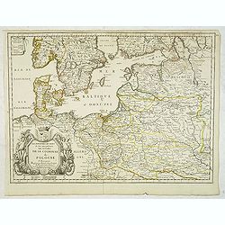
Les Royaumes du Nort ou Sont principalement les estats de la Couronne de Pologne. . .
Uncommon and detailed map of Poland. With decorative tittle cartouche lower left with a dedication to Jean-Jacques de Mesmes, comte d'Avaux (1640 – 9 January 1688) who ...
Date: Paris, c.1666
Selling price: ????
Please login to see price!
Sold in 2012
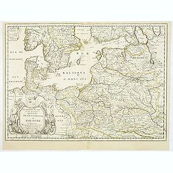
Les Royaumes du Nort ou Sont principalement les estats de la Couronne de Pologne. . .
Uncommon and detailed map of Poland. With decorative title cartouche lower left with a dedication to Jean-Jacques de Mesmes, comte d'Avaux (1640 – 9 January 1688) who w...
Date: Paris, c.1666
Selling price: ????
Please login to see price!
Sold in 2012
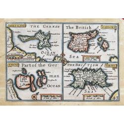
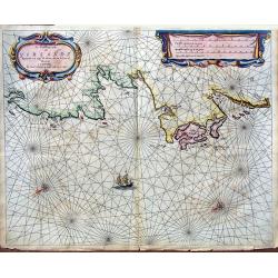
HOLYILAND; GARNSEY; FARNE; IARSEY;
"Miniature Speed" four maps one page: of Holy Island and Lindisfarne, the Channel Islands: Guernsey (including Herm & Sark) and Jersey. Very charming maps, ...
Date: London, 1666
Selling price: ????
Please login to see price!
Sold in 2013
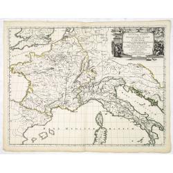
Illyricum Orientis In quo Partes II. Moesia et Thracia. Provinciae XI.
Attractive historical map of the area west of the Black Sea, today's Bulgaria, Rumania, etc. Based on the cartography of Nicolas Sanson and published by P.Mariette. With ...
Date: Paris, 1666
Selling price: ????
Please login to see price!
Sold in 2020
La Carelie et l'Ingrie, ou Ingermenland.
Depicts the gulf of Finland, Lake Ladoga and the River Neva. Pre-Saint Petersburg map.
Date: Paris, P.Mariette, 1666
Selling price: ????
Please login to see price!
Sold in 2018
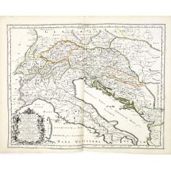
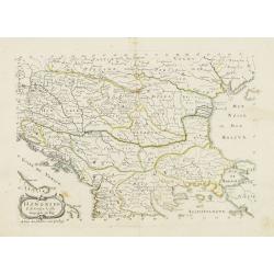
Illyricum Occidentis. Cuj Partes IV Rhaetia, Noricum Pannonia, et Illyris. . .
Attractive historical map of the area Balkans, Hungary, Austria, the Adriatic and the northern part of Italy. Engraved by Louis Cordier. Based on the cartography of Nicol...
Date: Paris, 1666
Selling price: ????
Please login to see price!
Sold in 2013
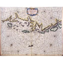
De Noordwest zyde van Yerlandt Beginnende van Capo de Hoorn; tot aen Schynes of Slyynhead . . .
A large, rare chart of part of the northwest coast of Ireland, including Achill Island, Donegal and Sligo.Originally produced by Theunisz Jacobsz for his Lichtende Colomn...
Date: Amsterdam, 1666
Selling price: ????
Please login to see price!
Sold in 2019
Geographia Synodica, Sive Regionum, Vrbium, et Locorum vbi Celebrata Sunt Concilia Oecumenica, Nationalia, Provincialia et Synodi Dioecesanae
Attractive historical map of Europe, the Mediterranean, and northern Africa. Extends to Cyprus and the Holy Land. Based on the cartography of Guillaume Samson and publish...
Date: Paris, 1666
Selling price: ????
Please login to see price!
Sold in 2020
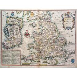
The Invasions of England and Ireland.
The Invasions of England and Ireland with all their Civill Wars since the Conquest.A finely engraved hand colored map with an attractive title cartouche that is surmounte...
Date: London, c 1666
Selling price: ????
Please login to see price!
Sold in 2014
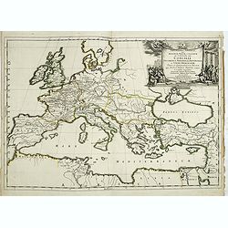
Geographia Synodica, Sive Regionum, Vrbium, et Locorum vbi Celebrata Sunt Concilia Oecumenica, Nationalia, Provincialia et Synodi Dioecesanae
Attractive historical map of Europe, the Mediterranean, and northern Africa. Extends to Cyprus and the Holy Land. Based on the cartography of Guillaume Samson and publish...
Date: Paris, 1666
Selling price: ????
Please login to see price!
Sold in 2016

Pascaart van Europa alsmede een gedeelte vande Kust van Africa. . .
An eye-catching chart of the entirety of Europe's coastline from northern Russia to Yugoslavia in the south. Also showing the West Coast of Africa as far as the Cape-Verd...
Date: Amsterdam, after 1666
Selling price: ????
Please login to see price!
Sold in 2023
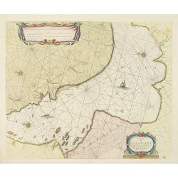
Caarte van Finmarcken van 't Eylandt Sanien tot Noordkyn...
Uncommon chart depicting the coast of Finnmark, in Norway.A decorative title cartouche, rhumb lines, three vessels and two compass roses. Published 1666 by J. Theunisz an...
Date: Amsterdam, 1666
Selling price: ????
Please login to see price!
Sold in 2018
![Finlande septentr[iona]le et Mérid[iona]le, Nylande, et Tavasthus. . .](/uploads/cache/36574-250x250.jpg)
Finlande septentr[iona]le et Mérid[iona]le, Nylande, et Tavasthus. . .
Map of the southern part of Finland, including Helsinki, Salo, Turku, etc.
Date: Paris, Mariette, 1666
Selling price: ????
Please login to see price!
Sold in 2017
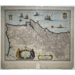
Portugallia et Algarbia quæ olim Lusitania. Auctore Vernando Alvero Secco.
An attractive map of Portugal, orientated with north to the right. The cartography is based on Fernando Alvarez Secco, a Portuguese chart maker whose 1560 map was used by...
Date: Amsterdam, 1666
Selling price: ????
Please login to see price!
Sold in 2016
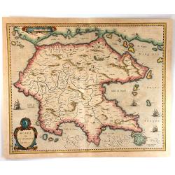
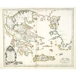
Morea Olim Peloponnesus
An attractive map of the Peloponnesos peninsula in southern Greece that was called Morea until well into the 19th century. The narrow isthmus between the mainland and the...
Date: Amsterdam, 1666
Selling price: ????
Please login to see price!
Sold in 2016

Relation du voyage en Moscovie, Tartarie, et Perse, augmentee en cette nouvelle edition... Le voyage de Jean Albert de Mandelslo aux Indes Orientales.
Complete title 'Relation du voyage en Moscovie, Tartarie, et Perse, augmentee en cette nouvelle edition... Le voyage de Jean Albert de Mandelslo aux Indes Orientales. Tra...
Date: Paris, 1666
Selling price: ????
Please login to see price!
Sold in 2017
Haute, ou Petite Pologne ou sont les Palatinats de Cracow, Sandomirie, et Lublin . . .
Regional map of a portion of Poland, including the Palatinats of Cracow, Sandomirie, and Lublin. Engraved by J.Sommer.Nicolas Sanson was to bring about the rise of French...
Date: Paris, 1666
Selling price: ????
Please login to see price!
Sold in 2019
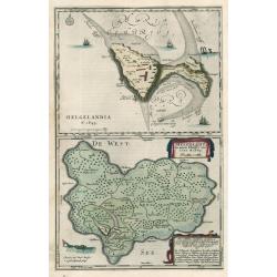
HELGELANDIA Helgelandt in annis Christi 800, 1300 & 1649
This map by Johannes Blaeu illustrates the impact of flooding on Helgelandia (modern day Heligoland), in the southeast corner of the North Sea. The area depicted is a sma...
Date: 1666
Selling price: ????
Please login to see price!
Sold in 2023
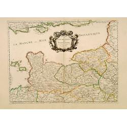
Duche et Gouvernement de Normandie.
Fine map of Normandy.This edition carries the date 1667.Nicolas Sanson was to bring about the rise of French cartography, although the fierce competition of the Dutch wou...
Date: Paris 1667
Selling price: ????
Please login to see price!
Sold
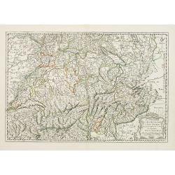
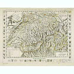
Les Suisses les Allies des Suisses et leurs Suiets..
Fine map of Switzerland. This edition carries the date 1667 and was engraved by R.Cordier Abbauil.Nicolas Sanson was to bring about the rise of French cartography, althou...
Date: Paris, 1648-1667
Selling price: ????
Please login to see price!
Sold in 2009
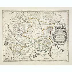
Turcomanie Georgie Commanie. . .
Attractive general map of Caucasus Mountains, Armenia and Georgia prepared by N.Sanson and published by Pierre Mariette.Published in an early edition of the small Sanson ...
Date: Paris, P. Mariette, 1667
Selling price: ????
Please login to see price!
Sold in 2008
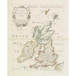
Isles Britaniques. . .
Map of Great Britain prepared by N.Sanson and published by Pierre Mariette.Published in an early edition of the small Sanson atlas L'Europe Dediée a Monseigneur . . . Le...
Date: Paris, P. Mariette, 1667
Selling price: ????
Please login to see price!
Sold in 2013
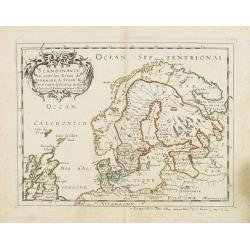
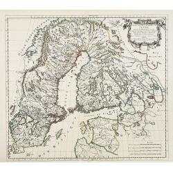
Scandinavie ou sont les Estats de Danemark, de Suede & C. . .
Map of Scandinavia prepared by N.Sanson and published by Pierre Mariette. Some contemporary manuscript annotations in brown ink. Published in an early edition of the smal...
Date: Paris, P. Mariette, 1667
Selling price: ????
Please login to see price!
Sold in 2012
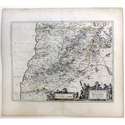
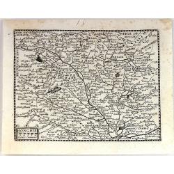
Hongrie & . . .
Map of Hungary prepared by N.Sanson and published by Pierre Mariette.Published in an early edition of the small Sanson atlas L\'Europe Dediée a Monseigneur . . . Le Tell...
Date: Paris, P. Mariette, 1667
Selling price: ????
Please login to see price!
Sold in 2009
Estats de la Couronne de Pologne.
Map of Poland prepared by N.Sanson and published by Pierre Mariette.Published in an early edition of the small Sanson atlas L'Europe Dediée a Monseigneur . . . Le Tellie...
Date: Paris, P. Mariette, 1667
Selling price: ????
Please login to see price!
Sold in 2008
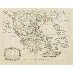
Partie de Turquie. . .
Map of Greece, the Aegean Sea and European part of Turkey prepared by N.Sanson and published by Pierre Mariette.Published in an early edition of the small Sanson atlas L\...
Date: Paris, P. Mariette, 1667
Selling price: ????
Please login to see price!
Sold in 2009
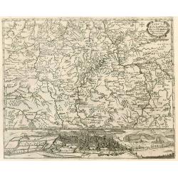
Tabula Geographica Archi-Dioecesis Trevirensis Antiquo-nova 1667.
Rare map of the region of Trier. Inset map with panorama of Trier.
Date: 1667
Selling price: ????
Please login to see price!
Sold in 2010
Carricta Meridionalis, The South part of Carrick.
Map of the south part of Carrick, a district in Scotland, outlined in colorful ribbons. Smaller town are shown within the region, many noticeably long the rivers that int...
Date: Amsterdam, c. 1667
Selling price: ????
Please login to see price!
Sold in 2010
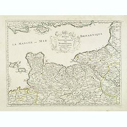
Duche et gouvernement de Normandie.
Fine map of Normandy, with the islands of Jersey and Guernsey. Engraved by R. Cordier d'Abbauil. This edition carries the date 1667. Nicolas Sanson was to bring about the...
Date: Paris, 1667
Selling price: ????
Please login to see price!
Sold
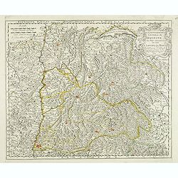
Le gouvernement general du Daufine, et.. La Savoye. . .
Fine map of south eastern part of France and part of Switzerland. Centered on Basle and the Alps.This edition carries the date 1667. Engraved by R. Cordier d'Abbauil.Nico...
Date: Paris, 1667
Selling price: ????
Please login to see price!
Sold
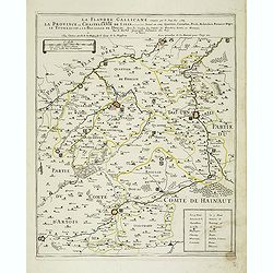
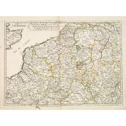
La Flandre Gallicane conquise par le Roy Lan c'est-à-dire La Province ou Chastellenie de Lille. . .
Scarce and detailed map of northern France, centered on Lille with title along the top. The map is dated 1667 and has the address "…proche le Fort l'Euesque, sur l...
Date: Paris, 1667
Selling price: ????
Please login to see price!
Sold
Les XIII Cantons Suisses Suivant le temps de leur Ligue . . .
Detailed map of thirteen Swiss counties with title at top. Coats of arms to the left, right and bottom. In bottom a key and a scale in French and Swiss miles.Engraved by ...
Date: Paris, 1667
Selling price: ????
Please login to see price!
Sold
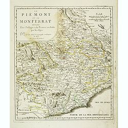
Le Piemont et le Monferrant avec que les Passage de France en Italie par Les Alpes . . .
Detailed map of the provinces Piedmont and Montferrat in Italy. Centered on Turin.
Date: Paris, 1667
Selling price: ????
Please login to see price!
Sold in 2021
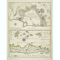
Candie ville metropolitaine de l'Isle de même nom . . . Isle de Candie . . .
Two maps on one sheet: In top Crete's metropolitan town Heraklion with a descriptive text inside the town "Candie ville metropolitaine de méme nom soûmise au grand...
Date: Paris, 1667
Selling price: ????
Please login to see price!
Sold in 2012
Picardie et les Pays Bas Catoliques &c. . .
Covering southern part of the Netherlands, Belgium and northern part of France. Engraved by R.Cordier Abbauil.Nicolas Sanson was to bring about the rise of French cartogr...
Date: Paris, 1667
Selling price: ????
Please login to see price!
Sold in 2014
Graecia Foederata sub Agamemnone, ob Helenae Raptum in Troiam coniurans . . .
A fine map of the ancient Greece. Engraved by Ludovicus Cordier. Nicolas Sanson was to bring about the rise of French cartography, although the fierce competition of the ...
Date: Paris, 1667
Selling price: ????
Please login to see price!
Sold in 2013
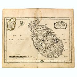
Les isles de Malte, Goze, & C. / par N. Sanson dªAbbeville, geographe ordinaire du Roy. . .
Map of Malta and Goza prepared by N.Sanson and published by Pierre Mariette.Published in an early edition of the small Sanson atlas L'Europe Dediée a Monseigneur . . . L...
Date: Paris, P. Mariette, 1667
Selling price: ????
Please login to see price!
Sold in 2015
Hongrie.
Rare map of Hungary published by Jollain in 1667. Published in "Trésor Des Cartes Geographiques Des Principaux Estats de Lunivers". This atlas was based upon B...
Date: Paris, 1667
Selling price: ????
Please login to see price!
Sold in 2019
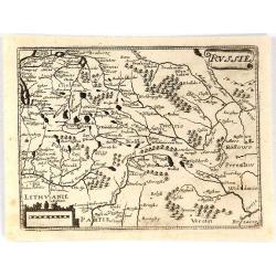
Russie.
Rare map of Russia published by Jollain in 1667. Published in "Trésor Des Cartes Geographiques Des Principaux Estats de Lunivers". This atlas is based upon Bo...
Date: Paris, 1667
Selling price: ????
Please login to see price!
Sold in 2018
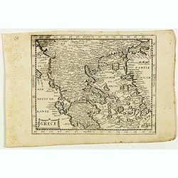
Grece.
Rare map of the Greece, published by Jollain in 1667. Published in "Trésor Des Cartes Geographiques Des Principaux Estats de Lunivers".This atlas is based upon...
Date: Paris, 1667
Selling price: ????
Please login to see price!
Sold in 2021
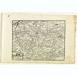
Pologne et Silesie.
Rare map of Poland and Silesia, published by Jollain in 1667. Lower right map number 17.Published in "Trésor Des Cartes Geographiques Des Principaux Estats de Luniv...
Date: Paris, 1667
Selling price: ????
Please login to see price!
Sold in 2023
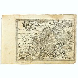
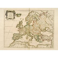
Nouvelle description de l'Europe.
Rare map of Europe with an oversized Iceland, published by Jollain in 1667. Published in "Trésor Des Cartes Geographiques Des Principaux Estats de Lunivers".Th...
Date: Paris, 1667
Selling price: ????
Please login to see price!
Sold in 2019
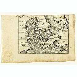
Danemarck.
Rare map of Denmark, published by Jollain in 1667. Published in "Trésor Des Cartes Geographiques Des Principaux Estats de Lunivers".This atlas is based upon Bo...
Date: Paris, 1667
Selling price: ????
Please login to see price!
Sold in 2021
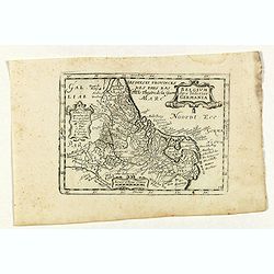
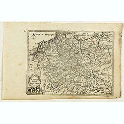
Belgium sive inferior Germania.
Rare map of The Low Countries with present-day The Netherlands, Belgium and Luxemburg, published by Jollain in 1667. Published in "Trésor Des Cartes Geographiques D...
Date: Paris, 1667
Selling price: ????
Please login to see price!
Sold in 2019
Nouvelle carte D'alemagne corigé.
Rare map of Germany, Poland and Switzerland, published by Jollain in 1667. Published in "Trésor Des Cartes Geographiques Des Principaux Estats de Lunivers".Thi...
Date: Paris, 1667
Selling price: ????
Please login to see price!
Sold in 2019
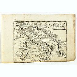
Italie Corse Sardaigne et Province adiacentes.
Rare map of general Italy, published by Jollain in 1667. Published in "Trésor Des Cartes Geographiques Des Principaux Estats de Lunivers".This atlas is based u...
Date: Paris, 1667
Selling price: ????
Please login to see price!
Sold in 2022
Europa Vetus.
A fine map of the ancient European continent.This edition carries the date 1668.Nicolas Sanson was to bring about the rise of French cartography, although the fierce comp...
Date: Paris, 1668
Selling price: ????
Please login to see price!
Sold
Europa Vetus.
Attractive historical map of Europe, the Mediterranean, and northern Africa. Extends to Cyprus and the Holy Land. Based on the cartography of Guillaume Samson and publish...
Date: Paris, 1668
Selling price: ????
Please login to see price!
Sold in 2013
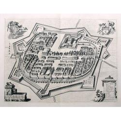
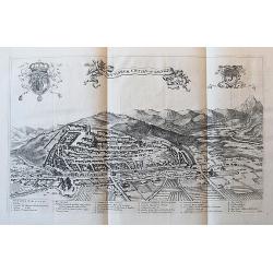
Carmagnolia.
Fantastic town plan of Carmagnolia (Carmagnola) near Turin, published in Theatrum Statuum Regiae Celsitudinis Sabaudiae Ducis, Pedemontii Principis, Cypri Regis from 1668...
Date: Amsterdam, ca. 1668
Selling price: ????
Please login to see price!
Sold in 2018
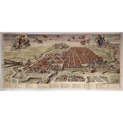
Augustae Tavrinorum Prospectus.
A beautiful, large, very detailed map of Turin (Torino), Italy by Joan Blaeu in Amsterdam in 1668, engraved by Thomas Borgonius. It is from the Atlas “Theatrum Statum R...
Date: Amsterdam, 1668
Selling price: ????
Please login to see price!
Sold in 2017
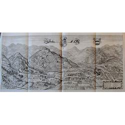
Garexium.
Impressive panoramic view of Garessio in Piemonte, published in Theatrum Statuum Regiae Celsitudinis Sabaudiae Ducis, Pedemontii Principis, Cypri Regis from 1668-1725. T...
Date: Amsterdam, ca. 1668
Selling price: ????
Please login to see price!
Sold in 2017
Salutiarum civitas, vulgo Saluzzo.
Large panoramic view showing the city of Saluzzo in Piemonte, published in Theatrum Statuum Regiae Celsitudinis Sabaudiae Ducis, Pedemontii Principis, Cypri Regis from 1...
Date: Amsterdam, ca. 1668
Selling price: ????
Please login to see price!
Sold in 2018

Avillianae Oppidum.
Superb view of Avigliana near Turin. Highly detailed with buildings, fields, a river, the city walls, and the castle above the city. Very decorative with boats on the lak...
Date: Amsterdam, ca. 1668
Selling price: ????
Please login to see price!
Sold in 2018
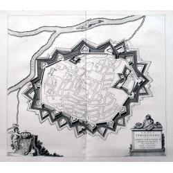
Urbis Vercellensis, à Carolo Emanuele II. . .
An unusual town plan of Vercelli, a city in the Piedmont region in Italy, at the river Sesia. Published in Theatrum Statuum Regiae Celsitudinis Sabaudiae Ducis, Pedemonti...
Date: Amsterdam, ca 1668
Selling price: ????
Please login to see price!
Sold in 2020
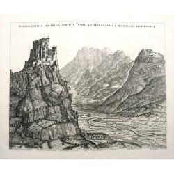
Scenographia Mirabilis Aedificii Templi et Monasterii S. Michaelis Archangeli.
A fantastic view of Sacra di San Michele on top of Monte Pirchiriano, near Turin. Highly detailed with the mountains, the valley with rivers, fields, and towns. A legend ...
Date: Amsterdam, ca. 1668
Selling price: ????
Please login to see price!
Sold in 2018
Trino
A fantastic town plan of Trino, a village in the Piedmont region of Italy, between between Turin, Vercelli and Casale Monferrato. It is situated near the River Po. Publis...
Date: Amsterdam, ca 1668
Selling price: ????
Please login to see price!
Sold in 2018
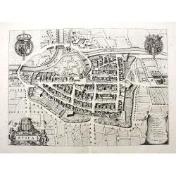
Busca.
Fantastic town plan of Busca near Cuneo, published in Theatrum Statuum Regiae Celsitudinis Sabaudiae Ducis, Pedemontii Principis, Cypri Regis from 1668-1725. Highly det...
Date: Amsterdam, ca. 1668
Selling price: ????
Please login to see price!
Sold in 2018
Raconisium. . .
A fantastic town plan of Racconigi; between Cuneo and Torino, published in Theatrum Statuum Regiae Celsitudinis Sabaudiae Ducis, Pedemontii Principis, Cypri Regis from 16...
Date: Amsterdam, ca 1668
Selling price: ????
Please login to see price!
Sold in 2018
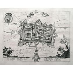
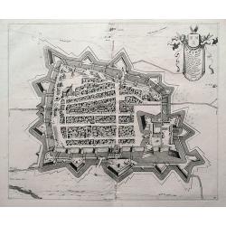
Crescentino.
A superb town plan of Crescentino, a village in the Piedmont region in Italy, between between Turin, Vercelli and Casale Monferrato. It is situated near the River Po. Pub...
Date: Amsterdam, ca 1668
Selling price: ????
Please login to see price!
Sold in 2018

A New Mape of Ye XVII Provinces of Low Germanie.
A detailed miniature map of the Netherlands / Low Countries. From the delightful pocket edition of John Speed's atlas by Van Den Keere, who signs as P. Kaerius.
Date: London, 1668
Selling price: ????
Please login to see price!
Sold in 2018
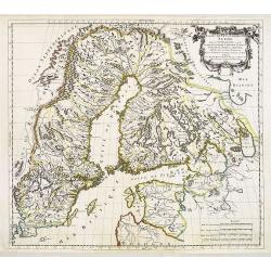
Gouvernement de Bahus tire de divers Memories.
An attractive map covering modern day Sweden and Norway, with just the northern tip of Jutland also. When this map was published Bahus belonged to Norway, however, it now...
Date: Paris, 1668
Selling price: ????
Please login to see price!
Sold in 2018
Dania.
A detailed miniature map of Denmark, and the southern part of Sweden. Also parts of northern Germany. From the delightful pocket edition of John Speed's atlas by Van Den ...
Date: London, 1668
Selling price: ????
Please login to see price!
Sold in 2018
Forte di S.a Maria di Lucerna.
An unusual plan of the forts near Torre Pellice, close to Torino in the Piedmont region in Italy. A beautifully engraved view showing the details of the fortifications wi...
Date: Amsterdam, ca 1668
Selling price: ????
Please login to see price!
Sold in 2020
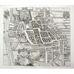
Ivrea.
A fantastic birds-eye view of the town of Ivrea located on the Dora Baltea river. The town lies to the north of the city of Torino. It is superbly engraved by de Ram, wit...
Date: Amsterdam, ca 1668
Selling price: ????
Please login to see price!
Sold in 2020
Cust van Hollant tusschen de Maes ende Texel.
Uncommon and detailed chart of the coast of Holland, including the southern tip of Texel. East at the top. Two fine compass cards, soundings and a large "Bree Veerth...
Date: Amsterdam 1669
Selling price: ????
Please login to see price!
Sold
De Cust van Hollant Tussen Texel en de Maes. . .
Signed lower right-hand corner: Jacob Colom opt Water Inde Vyerige Colom. Jacob Colom (1600-1673) was a printer, publisher and bookseller in the Fiery Colom in Amsterdam....
Date: Amsterdam, 1669
Selling price: ????
Please login to see price!
Sold in 2020
Estats de la couronne de SUEDE dans la Scandinavie..
Map of Sweden and Finland, with original or early outline hand-color. Numerous place-names of counties, cities, towns, physical features.
Date: Paris, 1669
Selling price: ????
Please login to see price!
Sold in 2009
Estats de la Couronne de Suede dans la Scandinavie, ou Sont Suede, Gotlande, Lapponie Suedoise, Finlande, Ingrie et Livonie Subdivisées en leurs Provinces . . .
Attractive map of Sweden, Finland and the Baltic States
Date: Paris, Marriette, 1669
Selling price: ????
Please login to see price!
Sold
De Zee Custen van Hispanien Van Gibraltar tot Caep S. Martin, als mede van Barbarien Van Seute tot C. de Tenes.
Fine of the Strait of Gibraltar and the westernmost Mediterranean. Large title cartouche featuring two seamen using navigation instruments. Rhumb lines and two compass r...
Date: Amsterdam, 1669
Selling price: ????
Please login to see price!
Sold in 2011
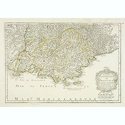
Comte et Gouvernement de Provence, avec les pays. . .
Fine map of the Provence, engraved by R. Cordier d'Abbauil. The cartouche has the date of 1669. Nicolas Sanson was to bring about the rise of French cartography, although...
Date: Paris, 1669
Selling price: ????
Please login to see price!
Sold in 2012
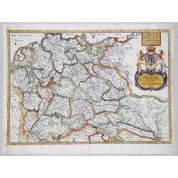
A GENERALL MAPP OF THE EMPIRE OF GERMANY with its severall Estates, 1669
A partly colored map of the German Empire. The earliest folio sized map of the region to be engraved in England.Blome's maps, because of their rarity and importance in th...
Date: London, 1669
Selling price: ????
Please login to see price!
Sold in 2020