Browse Listings in Europe
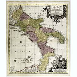
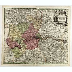
Neapolis Regnum . . .
Map of the region from Naples to Calabria. Cartouche representing Vesuvius erupting.Matthaus Seutter the elder first published his "Atlas Geographicus" in 1720 ...
Date: Ausburg, 1730
Selling price: ????
Please login to see price!
Sold in 2017
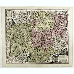
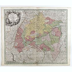
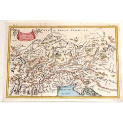
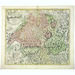
RHAETIA Foederata cum Confinibus et Subditis suis VALLE TELINA, COMITATU CLAVENNENSI ET BORMIENSI...delineata ˆ Gabriele Walzero..
Engraved by Andreas Silbereisen. This decorative map shows Graubünden. Very good impression done on thick paper.Matthaus Seutter the elder first published his "Atla...
Date: Ausburg, 1730
Selling price: ????
Please login to see price!
Sold in 2018
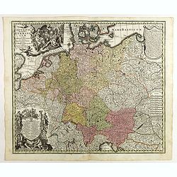
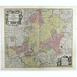
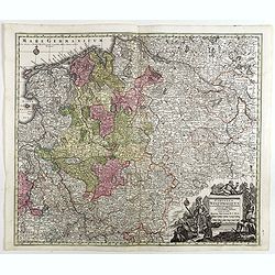
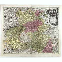
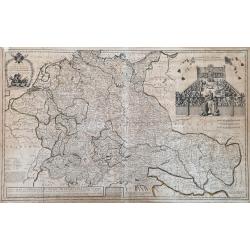
Imperium Romano Germanicum . . .
Map of central Europe centered on Germany, but including Poland, the Low Countries, Switzerland, Austria, etc. No text on verso. Very good impression done on thick paper....
Date: Ausburg, 1730
Selling price: ????
Please login to see price!
Sold in 2017
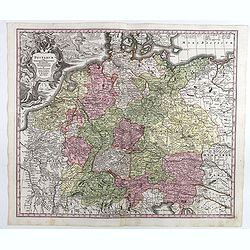
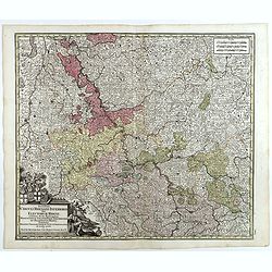
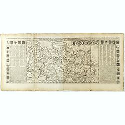
Postarum seu cursorum publicorum diverticula et mansiones per Germaniam et confin. Provincias, opera et manu M. Seutteri. . .
Post route map of Germany, including Poland, the Low Countries, Switzerland and Austria. No text on verso. Very good impression done on thick paper.Matthaus Seutter the e...
Date: Ausburg, 1730
Selling price: ????
Please login to see price!
Sold in 2017
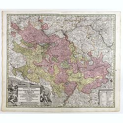
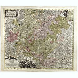
Palatinatus inferior, sive Electoratus Palatinus ad Rhenum . . .
Detailed map of the lower Rhine circles showing the area from east of Heidelberg towards Saarlouis. No text on verso. Very good impression done on thick paper.Matthaus Se...
Date: Ausburg, 1730
Selling price: ????
Please login to see price!
Sold in 2018
Trevirensis Archi-Episcopatus et Electoratus . . .
Map of the south-west part of Germany with one decorative figure cartouche. Including the river Rhine, Bonn, Trier, etc. No text on verso. Very good impression on thick p...
Date: Ausburg, 1730
Selling price: ????
Please login to see price!
Sold in 2018
Mappa geographica continens archiepiscopatum et electoratum Coloniensem . . .
Detailed map centered on Cologne. No text on verso. Very good impression done on thick paper.Matthaus Seutter the elder first published his "Atlas Geographicus"...
Date: Ausburg, 1730
Selling price: ????
Please login to see price!
Sold in 2017
L'Eveche et l'Etat de Liege . . .
Detailed map centered on Liege. No text on verso. Very good impression done on thick paper.Matthaus Seutter the elder first published his "Atlas Geographicus" i...
Date: Ausburg, 1730
Selling price: ????
Please login to see price!
Sold in 2018
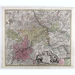
Circulus Suevicus in quo Ducatus Wirtenbergensis...
Map of Swabia including Strasburg, Manheim, Lucern, Boden See, Stuttgart.Matthaus Seutter the elder first published his "Atlas Geographicus" in 1720 and added t...
Date: Augsbourg, 1730
Selling price: ????
Please login to see price!
Sold in 2017
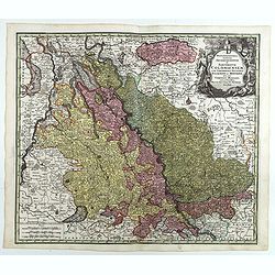
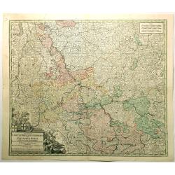
Mappa circuli Rhenani superioris . . .
Detailed map of Eastern Germany. Engraved detailed hand colored outline map. Includes decorative cartouche, compass rose and coat of arms. Shows cities and towns, place n...
Date: Augsbourg, 1730
Selling price: ????
Please login to see price!
Sold in 2018
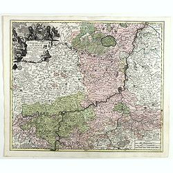
Circuli Rhenani Inferioris sive Electorum Rheni . . .
Engraved detailed map of the Rhine river with Dusseldorf, Bonn, Coblenz, Mainz. Includes decorative cartouche, compass rose and coat of arms. Shows cities and towns, plac...
Date: Augsbourg, 1730
Selling price: ????
Please login to see price!
Sold in 2018
Circulus Franconicus . . .
A fine map of the Franconia region of Germany, centered on Bamberg and Schweinfurth. Includes decorative uncolored cartouche, compass rose and coat of arms. Shows cities ...
Date: Augsbourg, 1730
Selling price: ????
Please login to see price!
Sold in 2018
Circulus Westphalicus in suas Provincias et Ditiones accurate distinctus et recentissime delineat / cura et caelo . . .
Engraved detailed hand colored map of Northern Germany. Includes decorative cartouche. Shows cities and towns, place names, rivers, forests and mountains.Matthaus Seutter...
Date: Augsbourg, 1730
Selling price: ????
Please login to see price!
Sold in 2017
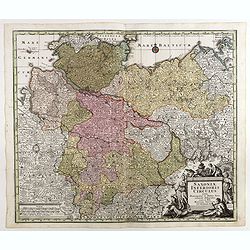
Saxoniae Superioris Circulus . . .
Map of Lower Saxony, extending from the Baltic to Berlin, Hall... With engraved detailed hand colored outline map. Includes decorative cartouche. Shows cities and towns, ...
Date: Augsbourg, 1730
Selling price: ????
Please login to see price!
Sold in 2018
Saxoniae Inferioris Circulus . . .
Map of lower Saxony, including Berlin, Hamburg, the Baltic region. With engraved detailed hand colored outline map. Includes decorative cartouche. Shows cities and towns,...
Date: Augsbourg, 1730
Selling price: ????
Please login to see price!
Sold in 2018
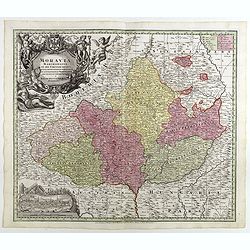
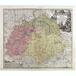
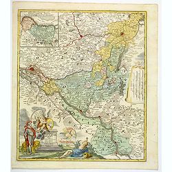
Moravia marchionatus in sex circulos divisus . . .
Map of the county of Moravia, boarded by Bohemia, Silesia, Hungary and Austria, with engraved detailed hand colored map. Includes decorative cartouche. Shows cities and t...
Date: Augsbourg, 1730
Selling price: ????
Please login to see price!
Sold in 2018
Comitatus Hanoviae . . .
A fine impression of this decorative map centered on Mons and Valenciennes with its uncolored title cartouche.Matthaus Seutter the elder first published his "Atlas G...
Date: Augsbourg, 1730
Selling price: ????
Please login to see price!
Sold in 2018
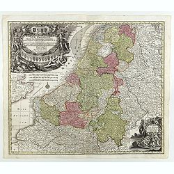
XVII Provinciae Belgii five Germaniae inferioris. . .
Decorative map of the Low Countries including Belgium, Luxemburg, the Netherlands, title surrounded by mythological figures and 17 coats of arms and 1 other cartouche low...
Date: Augsburg, 1730
Selling price: ????
Please login to see price!
Sold in 2018
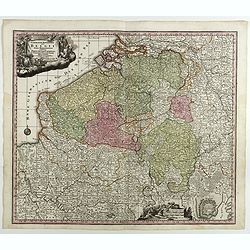
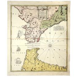
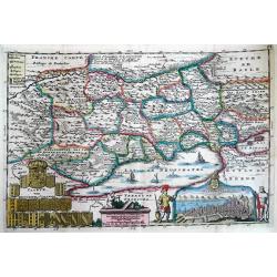
Germaniae Inferioris Sive Belgii Pars Meridionalis exhibens X. Provincias Catholi. Cum Confiniis Galliae Germ. Hollandiae recentissime et curatissime in lucem edita . . .
Decorative regional map of Belgium, centered on Namur. Inset plan of Oostende. Includes decorative cartouche. Shows cities and towns, place names, rivers and forests.Matt...
Date: Augsburg, 1730
Selling price: ????
Please login to see price!
Sold in 2018
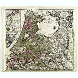
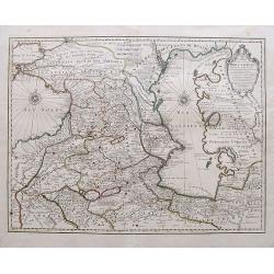
Tabula Comitatus Hollandiae in Praefecturas sua distributa, cui adjuncta est Provinc. Ultraiectina et maxima pars Geldriae summo studio delin. . .
Fine map of the provinces of North and South Holland. In upper left hand corner an inset with the islands of Texel and Vlieland. Just below the inset map a harbour scene ...
Date: Augsburg 1730
Selling price: ????
Please login to see price!
Sold in 2018
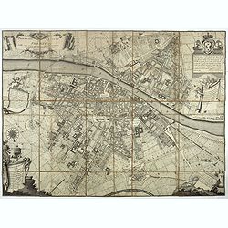
Delineatio ac finitima Regio Londini.
Centered on London, including towns of Hatfield, Tilbury, Walton on the Hill and Chertsey. Title in cartouche with royal arms, figure of Mercury, group of merchants. Boun...
Date: Ausburg, 1730
Selling price: ????
Please login to see price!
Sold in 2022
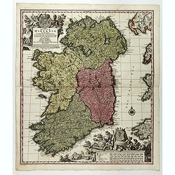
Regnum Hiberniae, tam Secundum IV Provincias Principales Ultoniam, Connaciam, Lageniam, et Momoniam quam peciales, accurate. . .
A very decorative and detailed map of Ireland based on Visscher's map. In upper left corner a large title cartouche with the royal British arms and lower right a large pi...
Date: Augsburg, 1730
Selling price: ????
Please login to see price!
Sold in 2017
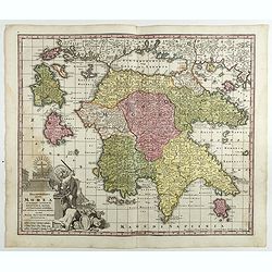
Peloponnesus Hodie Morea Ad Normam Veterum Et Recentiorum Mappa Accuratissime Adornata Aeri Incisa Et Venalis. . .
Decorative regional map of Morea and contiguous islands, with an ornate cartouche showing a lion bearing a sword defeating Turkish and other invaders.Matthaus Seutter the...
Date: Augsburg, 1730
Selling price: ????
Please login to see price!
Sold in 2018
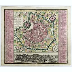
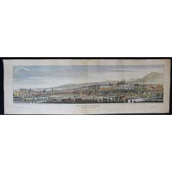
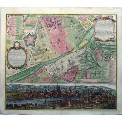
Milano, la Citta Principale et Fortezza Reale del Ducato medsino in Italia . . .
Fine example of Seutter's decorative and highly detailed plan of Milan, with a striking panoramic view of the City below. Matthaus Seutter the elder first published his &...
Date: Augsburg, 1730
Selling price: ????
Please login to see price!
Sold in 2017
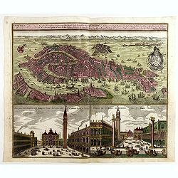
Venetia potentissima e la più magnifica fiorentissimae la più ricca città capitale della Serenissima repubblica . . .
Birds-eye plan view of Venice, depicting the city's architectural landmarks. Below Saint Marco square.Matthaus Seutter the elder first published his "Atlas Geographi...
Date: Augsburg, 1730
Selling price: ????
Please login to see price!
Sold in 2018
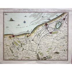
Carte Particulière des Environs de Dunkerque, Bergues, Furnes, Gravelines, Calais et autres.
A fine example of Covens & Mortier's regional map of the Belgian - French coastline showing; Dunkerque, Bergtues, Furnes, Gravelines, Calais and other cities. This at...
Date: Amsterdam, 1730
Selling price: ????
Please login to see price!
Sold in 2019
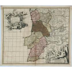
Nova Regni Portugallia et Algarbiae Descriptio.
A scarce map of Portugal with the various regions, towns, cities, rivers, and mountains depicted. The map features two large cartouches. The title cartouche has a drape h...
Date: Amsterdam, ca 1730
Selling price: ????
Please login to see price!
Sold in 2018
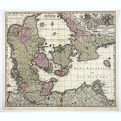
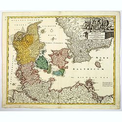
Daniae Regnum cum Ducatu Holsatiae et Slevici. . .
A decorative and detailed map of Denmark, enhanced by a lovely title cartouche in the top right corner, contains the Danish coat of arms, animals, cherubs and the bounty ...
Date: Nuremberg, 1730
Selling price: ????
Please login to see price!
Sold in 2020
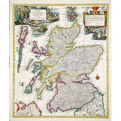
Nova et accurata Scotiae, secundum omnes Provincias.
A decorative and detailed map of Scotland. Embellished with two large cartouches. Matthaeus Seutter (1678-1757), was a cartographer of Vienna and Augsburg. 'Atlas Geogr'...
Date: Augsburg, ca 1730
Selling price: ????
Please login to see price!
Sold in 2020
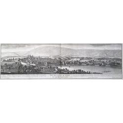
Veuë de la Ville de Geneve du coté du Midy.
A very large (77,5cm wide) 18th century copper engraving with a view of the Swiss city of Geneva from the south, with Lake Geneva behind the city. Engraved by A. Chopy on...
Date: Paris, 1730
Selling price: ????
Please login to see price!
Sold in 2018
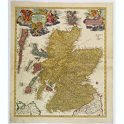
Magnae Britanniae Pars Septentrionalis qua REGNUM SCOTIAE. . .
A large, detailed and decorative map of Scotland with two superb cartouches. They are surrounded by mythical and allegorical figures, five putti, and the Royal & Scot...
Date: Nuremberg, 1730
Selling price: ????
Please login to see price!
Sold in 2019
![Collegium Reginense - Queen's College. [Oxford]](/uploads/cache/43162-250x250.jpg)
Collegium Reginense - Queen's College. [Oxford]
A lovely double page, folio copper engraved print of Queen's College, Oxford by William Williams (fl.1724-1733). Originally published in:- Oxonia Depicta sive Collegiorum...
Date: Oxford, ca 1730
Selling price: ????
Please login to see price!
Sold in 2020
Synopsis Circuli Rhenani Inferioris Sive Electorum Rheni...
A striking map of the lower Rhine by Seutter. Features a decorative title cartouche. One of the great 18th century German cartographic families was the Seutters. George ...
Date: Augsburg, 1730
Selling price: ????
Please login to see price!
Sold in 2021
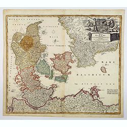
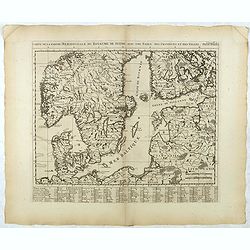
Regni Daniae in que sunt. . .
A nice colored map of Denmark, Schleswig-Holstein and Mecklenburg in Germany, extending from Hamburg in the south to southern Sweden in the north. Embellished with an att...
Date: Nurnberg, ca 1730
Selling price: ????
Please login to see price!
Sold in 2021
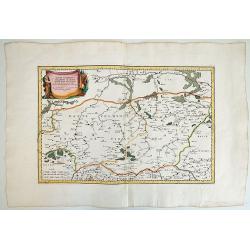
HAUTE VOLHYNIE ou PALATINAT DE LUSUC,titre de la grande carte de l Ukraine du S.le Vasseur de Beauplan.
Fine map of Volinia, a region actually in North West Ukraine, at that time territory of Poland Federation.The map has been prepared by Robert ( de Vaugondy ) in Paris and...
Date: Paris, 1730
Selling price: ????
Please login to see price!
Sold in 2019
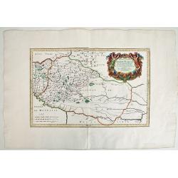
BASSE PODOLIE ou PALATINAT DE BRACLAW ,tiré de la Grande Ukraine de S. le Vasseur de Beauplan.
Fine map of Podolia ,a region actually in North West Ukraine ,but that time territory of Poland Confederation. This map by Robert ( de Vaugondy ) has been based in the pr...
Date: Paris, 1730
Selling price: ????
Please login to see price!
Sold in 2019
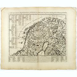
Regni Daniae in quo sunt. . .
A beautifully detailed c. 1730 J. B. Homann map of Denmark, that depicts both the Danish peninsular together with some parts of northern Germany and southern Sweden. The ...
Date: Nuremberg, 1730
Selling price: ????
Please login to see price!
Sold in 2021
Carte des Pays Voisins de la Mer Caspiene. . .
An excellent map of the Caspian Sea, todays Georgia, Armenia and Azerbaijan. Includes also a part of the Black Sea, Turkmenistan, Iran, Russia, and Turkey. Highly detaile...
Date: Amsterdam, ca 1730
Selling price: ????
Please login to see price!
Sold in 2019
Typus Geographieus Ducat. Lauen Burgici. . .
Johann Baptist Homann's detailed and well-engraved northern German provincial map has a striking, large and decorative title cartouche in the lower left corner. The map i...
Date: Nuremberg, 1730
Selling price: ????
Please login to see price!
Sold in 2019
Carte nouvelle de L'ISLE de CADIX & du Detroit de GIBRALTAR.
A decorative map centered on the Strait of Gibraltar. With an inset plan of Gibraltar, decorative title cartouche and four vessels.
Date: Nuremberg, 1730
Selling price: ????
Please login to see price!
Sold in 2019
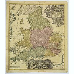
Magnae Britanniae. . . Regnum Angliae. . .
Johann Baptist Homann's well-engraved map of England and Wales has a large decorative cartouche at top right and a scrolled scene at bottom centre showing the King, (pres...
Date: Nurnberg, 1730
Selling price: ????
Please login to see price!
Sold in 2020
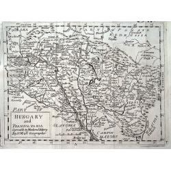
Hungary and Transilvania agreable to Modern History by H. Moll Geographer.
A scarce variant of Moll's map of Hungary and Transylvania, extending from Vienna to Belgrade.
Date: London, ca 1730
Selling price: ????
Please login to see price!
Sold in 2019
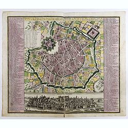
Milano, la Citta Principale et Fortezza Reale del Ducato medsino in Italia . . .
Fine example of Seutter's decorative and highly detailed plan of Milan, with a striking panoramic view of the City below. Matthaus Seutter the elder first published his &...
Date: Augsburg, 1730
Selling price: ????
Please login to see price!
Sold in 2023
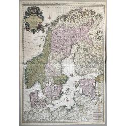
Carte des Couronnes du Nord qui Comprend les Royaumes de Danemark, Suede & Norwege.
A large format, highly detailed two sheet map of Scandinavia and the Baltic States. A beautifully engraved map with a highly decorative cartouche and two compass roses. S...
Date: Amsterdam, 1730
Selling price: ????
Please login to see price!
Sold in 2020
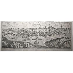
Prospect der Vestung Belgrad.
An exceptionally rare, unrecorded view of Belgrade, published around 1730.
Date: Unknown, ca. 1730
Selling price: ????
Please login to see price!
Sold in 2020
Veue de la ville de Geneve du coté du Septentrion.
A panoramic view of the city center of Geneva, Switzerland, as seen from Eaux Vives, Frontenex. The Jura mountains are in the background. After a design by Antoine Chopy ...
Date: Geneva, 1730
Selling price: ????
Please login to see price!
Sold in 2023
FLORENZ, FIRENZA la Capitale di Toscana etc. . .
A fine antique copper engraved map, a detailed plan with a fascinating panoramic view by Matthias Seutter, in Augsburg ca 1730. With two keys to the plan [numbers and let...
Date: Augsburg, ca 1730
Selling price: ????
Please login to see price!
Sold in 2020
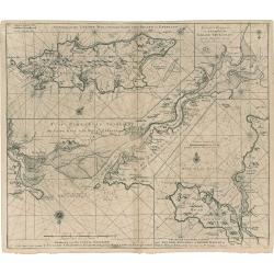
Eyland Man in St. Georges Channell
This is a scarce cartographic work by the Van Keulen family that provides three charts detailing islands in the Irish Sea.The chart at top left depicts the Isle of Man wi...
Date: Amsterdam, 1730
Selling price: ????
Please login to see price!
Sold in 2023
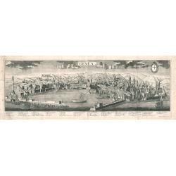
Genua
A panoramic bird's-eye-view of Genoa, Italy, printed on two sheets joined at the center. The work shows the harbor, city walls, buildings, churches, and hilly landscape i...
Date: Augsburg, 1730
Selling price: ????
Please login to see price!
Sold in 2023
A New Map of Germany, Hungary, Transilvania...
Large scale map of central Europe from Moll, published J. & T. Bowles, P. Overton & J. King. Shows the area within Danzig, Denmark, Paris, Venice, Trieste, Pragu...
Date: London, ca. 1730
Selling price: ????
Please login to see price!
Sold in 2023
Pianta della città di Firenze nelle sue vere misure colla descrizione dei luoghi più notabili di ciascun quartiere.
First edition of the plan of the city of Florence by Ferdinando Ruggieri. Decorated with a title cartridge, a dedication cartouche decorated with the coat of arms of the ...
Date: Florence, 1731
Selling price: ????
Please login to see price!
Sold in 2017
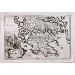
Hellas siue Graecia Propria.
A pleasant map of Southern Greece, portraying the ancient geography and cities, including the Pelopenesos, Athens, Corinth, Thebes, Argos, Mycenae and Sparta. With decora...
Date: Leipzig, 1731
Selling price: ????
Please login to see price!
Sold in 2018
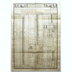
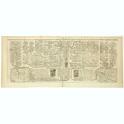
Cavalerie legere françoise et etrangere régimentée sous Louis XIII en 1635. Neuviémz feuille.
Table showing the structure of The regiment of the Kings Cavalry which was a regiment of the cavalry of the Kingdom of France created in 1635 (then regiment of dragons). ...
Date: Paris, ca. 1731
Selling price: ????
Please login to see price!
Sold in 2019
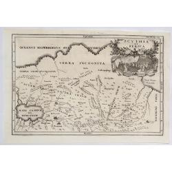
Scythia et Serica.
An interesting map of the region between the Caspian Sea and the Sea of China, much of which is 'Terra Incognita' in the North and East. Based upon 2000 year old geograph...
Date: Amsterdam, 1731
Selling price: ????
Please login to see price!
Sold in 2023
Sarmatda.
An interesting map of the Crimean Peninsula in Russia originally by Cellarius in 1731. It features a fine decorative cartouche with nomad peoples of the region. Christop...
Date: Venice, 1731
Selling price: ????
Please login to see price!
Sold in 2021
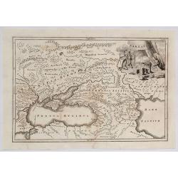
Bosporus, Maeotis, Iberia, Albania et Sarmatica Asiatica
Christoph Cellarius (1638-1707). Geographia Antiqua, 1686. A map of the Black Sea, the Caspium Sea and the area between. Embellished with a nice title-cartouche.
Date: Leipzig, Gledisch, 1732
Selling price: ????
Please login to see price!
Sold in 2009
![[untitled] coastal views of Corsica and Porto Venere, Italy.](/uploads/cache/92545-250x250.jpg)
[untitled] coastal views of Corsica and Porto Venere, Italy.
Unusual sheet with 20 sections of coastal views/land profiles of Italy and Corsica. Shows Porto Venere, Bastia, Calvi, and parts along the route. Each section with inform...
Date: Marseille, c1732
Selling price: ????
Please login to see price!
Sold in 2013
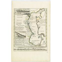
The Caspian Sea Drawn by the Czar's special command By Carl van Verden in the year 1719. 1720 and 1721. . .
Hand col. engraved map with 3 inset views. Includes geographical notes.With views of "Terky", "Derbent" and "Astracan"
Date: London, 1732
Selling price: ????
Please login to see price!
Sold in 2011
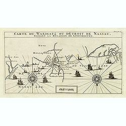
Carte Du Waeigatz ou Detroit De Nassau Suivant la Relation De Linschooten.
Decorative map of the Waeigatz Straits, between the southern part of Nova Zembla and the country of Samoyeds. Including two compass roses with radiating rhumb lines and v...
Date: Amsterdam, 1732
Selling price: ????
Please login to see price!
Sold in 2012
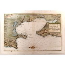
Plan de la Baye de Loristan
Nautical chart of the Gulf of Oristano in Sardinia. Decorated with a formidable compass rose, pointing due left. Little is known about Jacques Ayrouard and he only publi...
Date: Paris, 1732
Selling price: ????
Please login to see price!
Sold in 2014
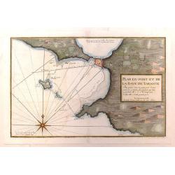
Plan du Port et de la Baye de Tarante
Nautical chart of the Gulf and Port of Taranto in Italy. Imposing large compass rose. Little is known about Jacques Ayrouard and he only published this single book on the...
Date: Paris, 1732
Selling price: ????
Please login to see price!
Sold in 2016
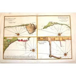
Plan du Mole de Naples, Veue en Plan de la Rade.
Four plans on one page of harbors on the Tyrrhenian Seacoast of Italy. Includes the harbors of Naples & Pozzuoli. The fortifications and buildings are well shown. Eac...
Date: Paris, 1732
Selling price: ????
Please login to see price!
Sold in 2014
The Countries of Vindelicia, Rhaetia & Noricum.
Finely copper engraved map of ancient Switzerland, Germany, Austria, italy and Hungary. Interesting drapery style title cartouche held in the air by a pair of putti. Chri...
Date: London, 1732
Selling price: ????
Please login to see price!
Sold in 2015
Caarte van Neufchatel et Valangin.
Highly detailed and decorative copper engraved map, showing the Lake Neuchâtel and surrounding area. Richly embellished with sailing ships on the lake, the title carto...
Date: Amsterdam, 1732
Selling price: ????
Please login to see price!
Sold in 2013
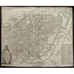
(Double page plan of Brussels)
Striking and highly detailed copper engraved city plan of Brussels, by Isaac Basire. For Mr. Tindal's Continuation of Mr. Rapin's History. This plan depicts roads, waterw...
Date: London, 1732
Selling price: ????
Please login to see price!
Sold in 2014
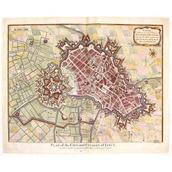
Plan of the City and Citadel of Lisle. (Lille)
Detailed city plan of the city and citadel of Lille in northern France. It is from Mr. Tindal's continuation of Mr. Tindal's "HISTORY OF ENGLAND" published in L...
Date: London, 1732
Selling price: ????
Please login to see price!
Sold in 2020
Carte générale des états du Czar Empereur de Moscovie ou l'on voit . . .
General map of Russia of the states of the Czar Emperor of Muscovy showing his possessions in Europe and Asia. To the left and right explanatory panels with coats of arms...
Date: Amsterdam, ca. 1732
Selling price: ????
Please login to see price!
Sold in 2017

Carte des Estats de la Couronne de Suède avec des Remarques et des Tables Tres Instructives.
Map shows Denmark with the southern part of Sweden and the northern coast of Germany with the island Rügen.This impressive map is the sixth plate in volume four of Chate...
Date: Amsterdam, 1732
Selling price: ????
Please login to see price!
Sold in 2023
Carte de la Partie Meridionale du Royaume de Suede...
Map of the southern part of Scandinavia with letter key at the bottom.Zacharie Chatelain (d.1723) was the father of Henri Abraham (1684-1743) and Zacharie Junior (1690-17...
Date: Amsterdam, ca. 1732
Selling price: ????
Please login to see price!
Sold in 2017
Carte de la Partie Septentrionale du Royaume de Suede...
Map of the northern part of Scandinavia. It covers the area straddling Norway, Sweden, Finland and Russia.Zacharie Chatelain (d.1723) was the father of Henri Abraham (168...
Date: Amsterdam, ca. 1732
Selling price: ????
Please login to see price!
Sold in 2017
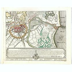
Plan de la Ville, Faubourg et environs de Dantzick, dédié et présenté à la Reine. (Gdansk )
Decorative and rare plan of Gdansk and the castle Weichselmunde by Jean de Beaurain (1696-1771). With a dedication to Marie Leszczynska (Queen of France). At the bottom o...
Date: Paris, 1732
Selling price: ????
Please login to see price!
Sold in 2020
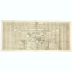
Carte Genealogique des Rois de Portugal & Partie des Differentes Branches qu'ils ont Formee avec le Blazon de leurs Armes & de leurs Alliances.
A genealogical tree of the Portuguese Kings with descriptive, from Chatelain's monumental 7 volume "Atlas Historique". Henri Abraham Chatelain (1684 – 1743) w...
Date: Amsterdam, 1720-1732
Selling price: ????
Please login to see price!
Sold in 2018
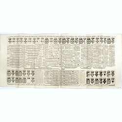
Carte genealogique des Ducs et Rois de Boheme et de Hongrie qui ont regné ou gouverné ces differents etats avec des instructions pour conduire à l'histoire de POLOGNE. . .
A genealogical tree of the Bohemian ducks and kings, from Chatelain's monumental 7 volume "Atlas Historique". This two sheet print features two maps (115 x 153m...
Date: Amsterdam, 1719-1732
Selling price: ????
Please login to see price!
Sold in 2017
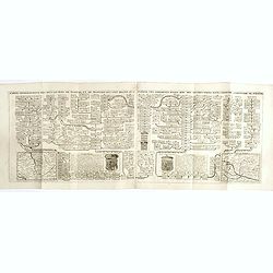
Carte pour servir à l'intelligence de l'histoire eclessiastique et a faire connoitre les persecutions de l'Eglise . . .
Two sheet engraving explaining the various religious divisions in Europe. In the center a map (210 x 350mm.) of Europe and Turkey. To the lower left a map of Egypt and to...
Date: Amsterdam, 1720-1732
Selling price: ????
Please login to see price!
Sold in 2017
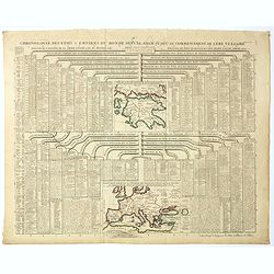
Chronologie des Etats & Empires du Monde depuis Adam jusqu'au au Commencement de l'Ere Vulgaire.
Graving showing the timeline of earth history from Adam to the beginning of the birth of Christ with inlay map of Peloponnese (120x130mm.) and in bottom Europe in the Bro...
Date: Amsterdam, 1720-1732
Selling price: ????
Please login to see price!
Sold in 2017
Carte genealogique des Ducs et Rois de Boheme et de Hongrie qui ont regné ou gouverné ces differents etats avec des instructions pour conduire à l'histoire de POLOGNE. . .
A genealogical tree of the Bohemian Duchess and Kings, from Chatelain's monumental 7 volume "Atlas Historique". This two sheet print features two small maps (11...
Date: Amsterdam, 1719-1732
Selling price: ????
Please login to see price!
Sold in 2018
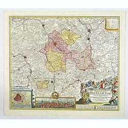
Episcopatus Hildesiensis nen non vicinorum Statuum delineatio Geographica. . .
Johann Baptist Homann's well-engraved map of the Bishopric of Hildesheim has a large decorative cartouche and a plan and profile inset of Hildesheim. The map has a tremen...
Date: Nuremberg 1732
Selling price: ????
Please login to see price!
Sold in 2020
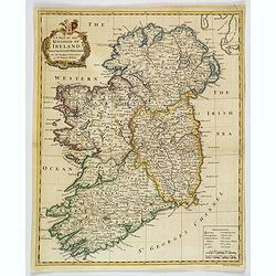
A Map of the Kingdom of Ireland.
A nice example of Seale's general map of Ireland produced for Tindal's "Continuation of Rapin's History." This map is quite detailed, accurate, and easy to read...
Date: London, ca 1732
Selling price: ????
Please login to see price!
Sold in 2019
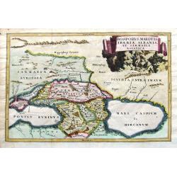
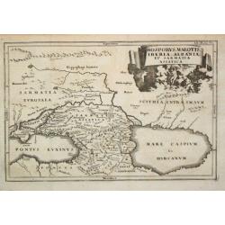
Bosporus, Maeotis, Iberia, Albania, et Sarmatia Asiatica.
An historical map of the Black Sea and the Caspian Sea, including todays Crimea, Armenia, Georgia, Azerbaijan, parts of Turkey and Russia. With cities, rivers, mountains,...
Date: Leipzig, 1732
Selling price: ????
Please login to see price!
Sold in 2019
Potentissimae Helvetiorum Reipublicae Cantones Trediecim cum Foederatis et Subjectis Provinciis . . .
A wonderful map of Switzerland, showing the 13 Cantons, by Johann Baptiste Homann, head of one of the most prolific German map publishing houses of the entire 18th Centur...
Date: Nuremberg, 1732
Selling price: ????
Please login to see price!
Sold in 2019