Browse Listings in Europe
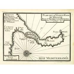
Plan de la Ville et Rade de Melasse.
An attractive chart centered on the Mediterranean. With scale and large compass-rose. Dated 1727, with the privilege of the King. From : Recueil des Plusieurs plans des p...
Date: Marseille, 1730
Selling price: ????
Please login to see price!
Sold in 2018
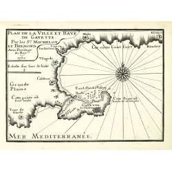
Plan de la Ville et Baye de Gayette.
An attractive chart centered on the Mediterranean. With scale and large compass-rose. Dated 1727, with the privilege of the King. From : Recueil des Plusieurs plans des p...
Date: Marseille, 1730
Selling price: ????
Please login to see price!
Sold in 2013
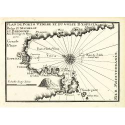
Plan de Porto Venere et du Golfe d'Especia.
An attractive chart centered on the Mediterranean. With scale and large compass-rose. Dated 1727, with the privilege of the King. From : Recueil des Plusieurs plans des p...
Date: Marseille, 1730
Selling price: ????
Please login to see price!
Sold in 2012
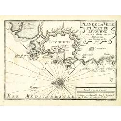
Plan de la Ville et Port de Livourne.
An attractive chart centered on Livorno. With scale and large compass-rose. Dated 1727, with the privilege of the King. From : Recueil des Plusieurs plans des ports et ra...
Date: Marseille, 1730
Selling price: ????
Please login to see price!
Sold in 2016
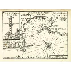
Plan du Port de Gênes.
An attractive chart centered on Genoa, with to the left an image of the 77-meter-tall Lanterna tower. With scale and large compass-rose. Dated 1727, with the privilege of...
Date: Marseille, 1730
Selling price: ????
Please login to see price!
Sold in 2012
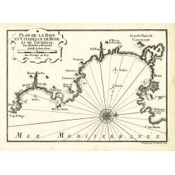
Plan de la Baye et Citadelle de Rose et de Tourrille.
An attractive chart centered on Tourrille and Roses in Catalonia. With scale and large compass-rose. Dated 1727, with the privilege of the King. From : Recueil des Plusie...
Date: Marseille, 1730
Selling price: ????
Please login to see price!
Sold in 2010
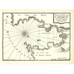
Plan du Port de Cadequié en Catalogne.
An attractive chart centered on the town and Bay of Cadequie or Cadaquez in Catalonia. With scale and large compass-rose. Dated 1727, with the privilege of the King. From...
Date: Marseille, 1730
Selling price: ????
Please login to see price!
Sold in 2010
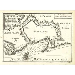
Plan de la Ville det Port de Barcelone.
An attractive chart centered Barcelona. With scale and large compass-rose. Dated 1727, with the privilege of the King. From : Recueil des Plusieurs plans des ports et rad...
Date: Marseille, 1730
Selling price: ????
Please login to see price!
Sold in 2010
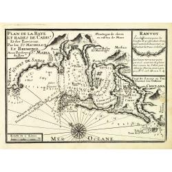
Plan de la Baye et Rade de Cadis.
An attractive chart of Cadiz. With scale and large compass-rose. Dated 1730, with the privilege of the King. From : Recueil des Plusieurs plans des ports et rades de la M...
Date: Marseille, 1730
Selling price: ????
Please login to see price!
Sold in 2012
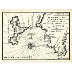
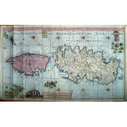
Partie de l'isle d'Yvice, et des isles fromentières.
An attractive chart centered on the south coasts of Ibiza and the Island of Formentera. With scale and large compass-rose. Dated 1730, with the privilege of the King. Fro...
Date: Marseille, 1730
Selling price: ????
Please login to see price!
Sold
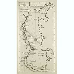
Reduction De La Carte De La Mer Caspienne. . .
Uncommon map of the Caspian Sea. Engraved by de Berey.
Date: Paris, c.1730
Selling price: ????
Please login to see price!
Sold in 2011
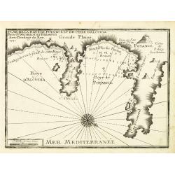
Plan de la Baye de Poyance et de celle d'Alcudia.
An attractive chart centered on the Mediterranean. With scale and large compass-rose. Dated 1727, with the privilege of the King. From : Recueil des Plusieurs plans des p...
Date: Marseille, 1730
Selling price: ????
Please login to see price!
Sold
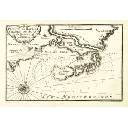
Plan de la Baye et Rades du Sofa.
An attractive chart centered on the Mediterranean. With scale and large compass-rose. Dated 1727, with the privilege of the King. From : Recueil des Plusieurs plans des p...
Date: Marseille, 1730
Selling price: ????
Please login to see price!
Sold in 2022
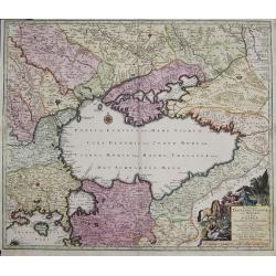
Nova Mappa Geographica Maris Assoviensis Vel De Zabache Et Paludis Maeotidis accurate aeri incis et in luce edita . . .
Striking map of the Sea of Azov with adjacent countries and the Strait of Kerch, with a decorative allegorical cartouche, showing the costumes of the indigenous people of...
Date: Augsburg, 1730
Selling price: ????
Please login to see price!
Sold in 2020
![Portugalliae et Algarbiae. [with large Regnum Brasiliae...inset]](/uploads/cache/32345-250x250.jpg)
Portugalliae et Algarbiae. [with large Regnum Brasiliae...inset]
Decorative map of Portugal, ornated with a large title cartouche, with Neptune, a queen, cherubs, coats of arms and the Portuguese fleet. In lower right inset map of Braz...
Date: Augsburg, 1730
Selling price: ????
Please login to see price!
Sold in 2013
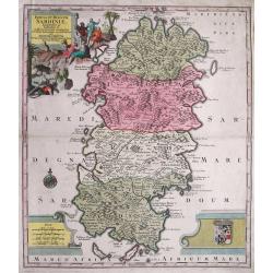
Cataloniae principatus et Ruscionis ae Cerretaniae Comitatuum. . .
Decorative map of Catalonia in southern Spain with a large title cartouche with cherubs and coats of arms.A second state.
Date: Augsburg, 1730
Selling price: ????
Please login to see price!
Sold in 2012
Dantiscum f. Gedanum.../ Dantzig eine berühmte...
SCARCE town-plan of Danzig (Gdansk) in Poland. Superbly engraved and very detailed map of the city and the fortifications. Also showing fields, woods, a few buildings, ou...
Date: Augsburg, 1730
Selling price: ????
Please login to see price!
Sold in 2013
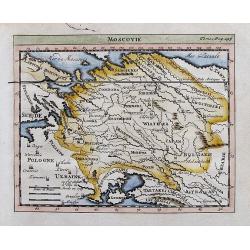
Moscovie.
Attractive small map of parts of Russia. Detailed map, includes Riga, Kiev, Moscow, Astrachan, Kazan, Perm, Smolensk, Crimea, many rivers, etc.
Date: ca. 1730
Selling price: ????
Please login to see price!
Sold in 2012
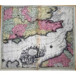
La plus grande partie de la Manche, qui contient les cotes d' Angleterre et celles de France...
Superb map of the English Channel, also showing England including Gloucester, Oxford, London and Colchester, with the Post Roads marked. With French coast including Calai...
Date: Augsburg, 1730
Selling price: ????
Please login to see price!
Sold in 2012
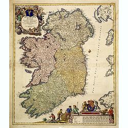
Hiberniae regnum. . .
A detailed and decorative map of Ireland, with an attractive uncolored title cartouche.
Date: Nurnberg 1730
Selling price: ????
Please login to see price!
Sold in 2012
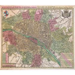
Le Plan de Paris, ses Faubourgs et ses Environs...
A spectacular city plan of Paris illustrating with deepest detail churches, palaces, streets, gardens, etc. The work embellished by a compass rose and the royal coat of a...
Date: Augsburg, 1730
Selling price: ????
Please login to see price!
Sold in 2014
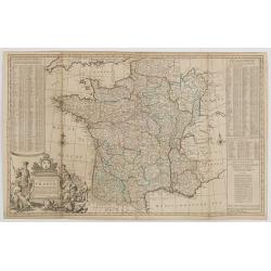
A NEW AND EXACT MAP OF FRANCE...
Decorative two-sheet map of France. Very detailed with towns, rivers, etc. Postal roads are marked with distances between points indicated in leagues. Battle sites in whi...
Date: London, c1730
Selling price: ????
Please login to see price!
Sold in 2014

Nova et accurata cominatus Zelandiae Tabula . . .
Fine and detailed map of the province of Zeeland. Originally issued by Cornelis Allard, now re-published with updated address by the Amsterdam publishers' Covens and Mort...
Date: Amsterdam, 1730
Selling price: ????
Please login to see price!
Sold in 2013
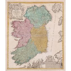
Hiberniae regnum ...
A detailed and decorative map of Ireland, with attractive cartouches.
Date: Nurnberg, 1730
Selling price: ????
Please login to see price!
Sold in 2013
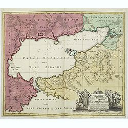
Nova et accurata Tartariae Europae seu minoris et in specie Crimeae delineatio geographica. . .
Map depicting the Black Sea with the peninsula Krim and its bordering countries, showing Asia Minor,Turkey, Bulgaria, Beesarabia, Armenia, Georgia and Ukraine etc.
Date: Augsburg, 1730
Selling price: ????
Please login to see price!
Sold in 2014
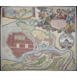
Topographische Vorstellung der Neuen Russischen Haupt-Residenz und See- Stadt St. Petersburg sammt ihrer zu erst aufgerichten Festung
Map shows a city map of St. Petersburg, a beautiful cartouche, a location map of St. Petersburg and Chronschloss. Homann was born in Oberkammlach near Kammlach in the Ele...
Date: Nuremberg, 1730
Selling price: ????
Please login to see price!
Sold in 2015
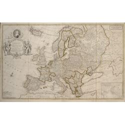
To Her Most Sacred Majesty Carolina Queen of Great Britain, France and Ireland, This Map of Europe According to the Newest and most Exact Observations is most Humbly Dedicated by your Majesty's most Obe
This edition was published by J. Bowles, T. Bowles, P. Overton, J. King, in London c.1730. Two sheets conjoined, total 595 x 975mm. Moll's large format map of Europe, ded...
Date: London, 1730
Selling price: ????
Please login to see price!
Sold in 2017
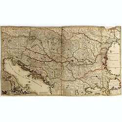
Novissima Tabula Regni Hungariae et Regionum . . . ut Transilvaniae. Valachiae. Moldaviae Serviae. Romaniae. Bulgariae Bessarabiae. Croatiae. Bosniae. Dalmatie. Slavoniae . . .
A large and impressive map of Central Europe including Hungary, the Danube Delta, Transylvania, Walachia, Moldavia, Croatia, Bosnia, Dalmatia, Slavonia, Morlachia and the...
Date: Amsterdam, 1730
Selling price: ????
Please login to see price!
Sold in 2015
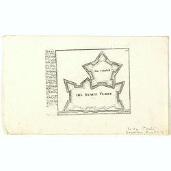
Die Stadt Terky. (Tarki)
Plan of Tarki, with a description and key to the left. Tarki is an urban locality under the administrative jurisdiction of Sovetsky City District of the City of Makhachka...
Date: Augsburg, 1730
Selling price: ????
Please login to see price!
Sold in 2015
Accurata Designatio Celebris Freti prope Andalusiae Castellum Gibraltar...
Very decorative large-scale map of southern Spain. Shows the area from Cadiz and Jerez to Malaga and Motril in great detail. Includes two inset maps of Minorca and Ceuta,...
Date: Augsburg, 1730
Selling price: ????
Please login to see price!
Sold in 2016
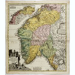
Insula et Regnum Sardiniae,. . .
Fine map of Sardinia, showing the island in great detail. Decorated with a large title cartouche with figures and animals. Further enhanced with a large coat of arms, dis...
Date: Augsburg, 1730
Selling price: ????
Please login to see price!
Sold in 2015
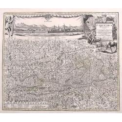
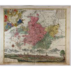
Carinthia Ducatus...
A very decorative and detailed map of Carinthia in Austria. Filled with place names, roads, rivers, lakes, mountains,... A fine large panorama of the city of Klagenfurt i...
Date: Augsburg, ca. 1730
Selling price: ????
Please login to see price!
Sold in 2017
Norvegiae Accurata Tabula in qua Praefecturae quinque Generales. . .
Johann Baptist Homann's well-engraved map has a large decorative cartouche. Detailed map of Norway. The southern part of the country is the focus of the main map, while t...
Date: Nuremberg, ca. 1730
Selling price: ????
Please login to see price!
Sold in 2020
Nieuwe en Nette Afteekening van het Eyland Corsica en het Eyland Elba vertoonende alle desselfs Havenen, Steeden en Rivieren. Nieuwe en Nette Afteekening van het Eyland of Koninkryk Sardinia vertoonende alle desselfs Zee Havenen Anker Plaetsen Rivier ...
An extremely detailed, large sea chart of Corsica, Sardinia and Elba, with many sailing ships, compass roses, decorative cartouches, coat of arms, etc.One of the most dec...
Date: Amsterdam, 1730
Selling price: ????
Please login to see price!
Sold in 2020
Cercle du Haut Rhin...
A detailed map by Pierre van Der Aa of the German province of Haut Rhin, following the new observations of the “Academie Royale des Sciences”. It has a beautiful cart...
Date: Leiden, 1730
Selling price: ????
Please login to see price!
Sold in 2016
Cercle de la Basse Saxe.
A detailed map by Pierre van Der Aa of the German province of Lower Saxony, following the new observations of the “Academie Royale des Sciences”. It has a beautiful c...
Date: Leiden, 1730
Selling price: ????
Please login to see price!
Sold in 2016
Cercle de Franconie.
A detailed map by Pierre van Der Aa of the German province of Franconie, following the new observations of the “Academie Royale des Sciences”. It has a beautiful cart...
Date: Leiden, 1730
Selling price: ????
Please login to see price!
Sold in 2016
Le Duche de Lunebourg.
A detailed map by Pierre van Der Aa of the German province of Lunebourg following the new observations of the “Academie Royale des Sciences”. It has a beautiful carto...
Date: Leiden, 1730
Selling price: ????
Please login to see price!
Sold in 2016
De Stoel des Oorlogs in Italien...
A large and detailed map of Northern Italy by Visscher & Schenk. It was printed on two conjoined sheets of paper. It shows the centre of the war in Italy in the state...
Date: Amsterdam, ca. 1730
Selling price: ????
Please login to see price!
Sold in 2016
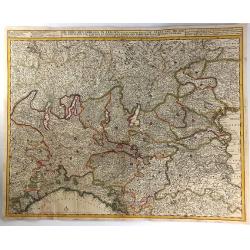
S.R.I. Cirulus Rhenanus Superior.
A beautifully detailed Homann Heirs map of Upper Rhine region. Covers from Coblentz eastward as far as Schweinfurt; northwards as far as Gottingen; and southwards as far ...
Date: Nuremberg, 1730
Selling price: ????
Please login to see price!
Sold in 2016
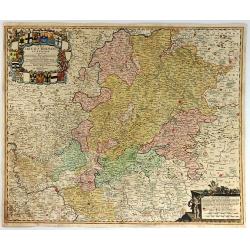
Exactissima Palatinatis ad Rhenum.
A beautifully detailed Homann Heirs map, covering southern part of the river Rhine. Includes the towns of Frankfurt, Heidelberg, Neustadt, Saarbrücken, Mainz, etc.Enhanc...
Date: Nuremberg, 1730
Selling price: ????
Please login to see price!
Sold in 2016
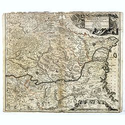
Transylvaniae, Moldaviae, Walachiae, Bulgariae nova et accurata Delineatio, Magnam Partem Hodierni Theatri Bellici ob oculos ponens opera et fumtibus .
Uncommon map showing Southeast Europe with Transylvania, Moldavia, Bulgaria and the Walachei. With the mouth of the river Danube into the Black Sea. In the upper right co...
Date: Nurember, 1730
Selling price: ????
Please login to see price!
Sold in 2016
Mappa Geographica in qua Ducatus Lotharingiae et Barr
A very decorative map of the Lorraine region in France. Detail includes that of the towns, cities, and topography. It has a title cartouche showing people hunting and mak...
Date: Nuremberg, 1730
Selling price: ????
Please login to see price!
Sold in 2016

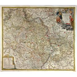
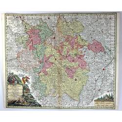
Bavariae Circulus et Electorat In suas quasque Ditiones tam cum Adiacentibus Quam Insertis Regionibus
This map covers a region including Nuremberg, Passau, and Innsbruck. It is densely packed with information, lakes, rivers, towns, and villages. A large figurative title ...
Date: Nuremberg, 1730
Selling price: ????
Please login to see price!
Sold in 2016
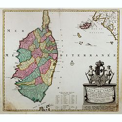
Nouvelle carte de l'Isle de Corse apartenante a la Republique de Genes. . .
Map of Corsica with a splendid baroque cartouche. Carte de la Corse, sur laquelle figure le blason de l’Ile divisé en deux parties égales, la moitié droite est rése...
Date: Amsterdam, 1730
Selling price: ????
Please login to see price!
Sold
![Nieuwe wassende grade paskaart, vertoonde t. westerlykste deel der zee kusten van Europa : strekkende van Hitland, of Ysland, tot Vooby t'Naauw van de straat waar in ook vervangen syn, d'Carnarise en Vlaamse Eyan[d] seer dienstif](/uploads/cache/97799-250x250.jpg)
Nieuwe wassende grade paskaart, vertoonde t. westerlykste deel der zee kusten van Europa : strekkende van Hitland, of Ysland, tot Vooby t'Naauw van de straat waar in ook vervangen syn, d'Carnarise en Vlaamse Eyan[d] seer dienstif
An impressive large sea chart of the north Atlantic, extending from Iceland to the Canary islands. It depicts part of North Africa, Spain, Portugal, France, UK, Ireland, ...
Date: Amsterdam, 1730
Selling price: ????
Please login to see price!
Sold in 2016
Roma Victrix
A small map of ancient Rome, showing a few buildings and streets, plus it names several gates (Porta) of the Aurelian Walls!
Date: Nuremberg, ca 1730
Selling price: ????
Please login to see price!
Sold in 2016
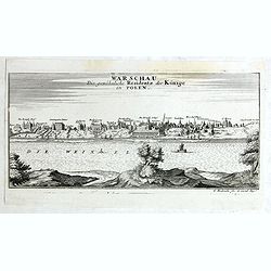
Warschau die gewöhnliche Residenz der Könige in Polen.
Very rare panoramic view of Wachau published by Gabriel Bodenehr, first state without the text on the left.
Date: Augsburg, 1730
Selling price: ????
Please login to see price!
Sold in 2018
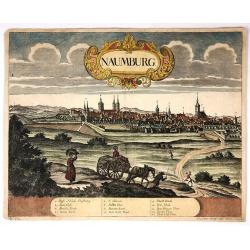
Naumburg.
Attractive colored city view of Naumburg, Germany. I was by Peter Wolff and engraved by Erbert in 1730. There is a lovely baroque title cartouche and a description chart ...
Date: Frankfurt, 1730
Selling price: ????
Please login to see price!
Sold in 2018
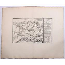
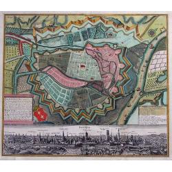
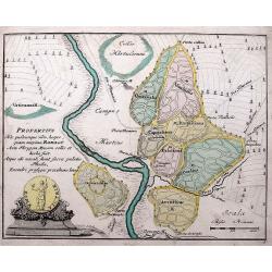
Plan de la Situation du Siege du Quesnoy Investi.
A fine detailed map of the fortifications around the town Quesnoy at the time of the siege in 1712. Le Quesnoy is a commune in the Nord department in northern France.Cove...
Date: Amsterdam, ca. 1730
Selling price: ????
Please login to see price!
Sold in 2019
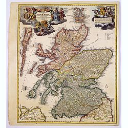
Magnae Britanniae Pars Septentrionalis qua REGNUM SCOTIAE. . .
A large, detailed and decorative map of Scotland with two superb cartouches. They are surrounded by mythical and allegorical figures, five putti, and the Royal & Scot...
Date: Nuremberg, 1730
Selling price: ????
Please login to see price!
Sold in 2017
Ducatuum Livoniae et Curlandiae cum vicinis Insulis Nova Exhibitio Geographica. . .
A detailed map of the northern Baltic coast by Homann, pre-dating the privilege given to him. An attractive map covering Estonia and Latvia shows the fortified towns of G...
Date: Nüremberg, 1730
Selling price: ????
Please login to see price!
Sold in 2017
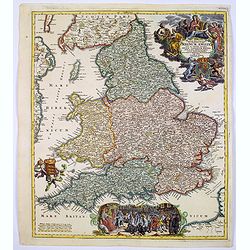
Magnae Britanniae..Regnum Angliae. . .
Johann Baptist Homann's well-engraved map of England and Wales has a large decorative cartouche at top right and a scrolled scene at bottom centre showing the King, (pres...
Date: Nurnberg, 1730
Selling price: ????
Please login to see price!
Sold in 2017
Tabula Peculiaris Regionum, quas Apostoli Perlustrarunt. . .
This map shows the entire eastern Mediterranean, with many ancient places named along the coast lines. This map depicts Paul the Apostle's journey from Jerusalem to Rome,...
Date: Pars, ca. 1730
Selling price: ????
Please login to see price!
Sold in 2020
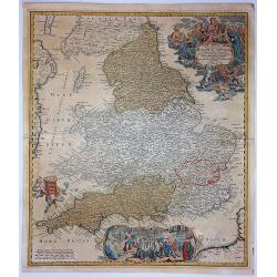
Magne Britanniae Pars Meridionalis in Qua Regnum Angliae...
A detailed map with a large decorative cartouche at the top right featuring a woman playing the harp, a shield with unicorns and a lion, and two putti. A large scene at t...
Date: Nuremberg, 1730
Selling price: ????
Please login to see price!
Sold in 2017
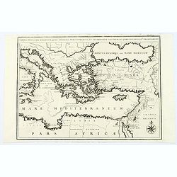
Mare Mediterraneum juxta Regna et Provincias, quas Alluit Distinctum et Cognominatum.
An old colored copperplate map of the middle west Mediterranean Sea. It shows the neighboring countries of Spain, Italy, the Balkans, Greece, as well as the north coast o...
Date: Ausburg, ca. 1730
Selling price: ????
Please login to see price!
Sold in 2019
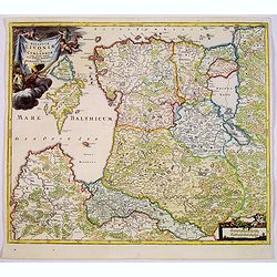
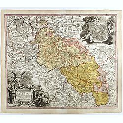
Episcopatus Numburgensis et Cizensis. . .
This interesting map of Eastern Germany by Seutter shows the region just to the south of Merseburg, with Naumburg to the west and Zeitz to the south. At the bottom is a l...
Date: Nuremberg, 1730
Selling price: ????
Please login to see price!
Sold in 2021
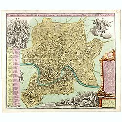
Veteris et Modernaeurbis Romae Ichnograpphia..
A striking city plan of Rome with vibrant original color. The plan is beautifully embellished with allegorical scenes. In the lower right a vignette portraying the tribut...
Date: Augsburg, ca. 1730
Selling price: ????
Please login to see price!
Sold in 2017
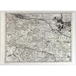
Superioris et inferioris ducatus Silesiae in suos XVII minores principatus et dominia divisi nova tabula. . .
Detailed map of the region dissected by the Oder, showing Wroclaw, Breslau, Silesia, with a large cartouche and large inset plan of Brelaw, held aloft by Cherubs. Shows c...
Date: Nuremberg, ca. 1730
Selling price: ????
Please login to see price!
Sold in 2018
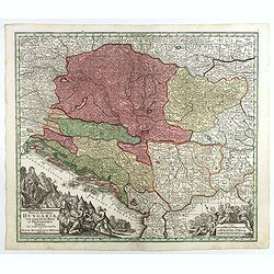
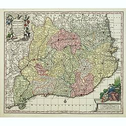
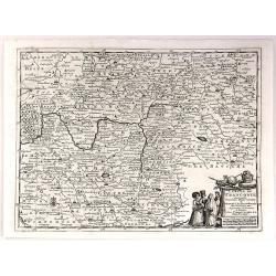
Nova et accurata Hungariae cum adiacentib. regn. et principatibus tabula. . .
Map of the Balkan showing Hungary, Serbia, Croatia, Bosnia and Herzegovina and Albania. With two beautiful cartouches. Shows cities and towns, place names, rivers, forest...
Date: Augsbourg, 1730
Selling price: ????
Please login to see price!
Sold in 2018
Transylvaniae, Moldaviae, Walachiae, Bulgariae, nova et accurata Delineatio, Magnam Partem Hodierni Theatri Bellici . . .
Map shows Southeast Europe with Transylvania, Moldavia, Bulgaria and the Walachia, with engraved detailed hand colored map. Includes decorative cartouche. Shows cities an...
Date: Augsbourg, 1730
Selling price: ????
Please login to see price!
Sold in 2017
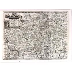
Borussiae Regnum sub fortissimo Tutamine et justissimo Regimine Friderici Wilhelmi. . .
Covers Prussia, Pomerania, Planica, Hockerlandia, Pomesania, Warmiaermelandia, Natanglensis, Galindia, Nandrovia, Sclavonia, and the Baltic Sea.In top center a large cart...
Date: Augsbourg, 1730
Selling price: ????
Please login to see price!
Sold in 2017

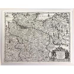
Marchionatus Brandenburgensis Ducatus Pomeraniae et Ducatus Mecklenburgicus.. . . .
Seutter's well-engraved map has a large decorative cartouche. Including the towns of Wismar, Stettin, Berlin, etc.Matthaus Seutter the elder first published his "Atl...
Date: Augsbourg, 1730
Selling price: ????
Please login to see price!
Sold in 2017
Synopsis Plagae, Septentrionalis sive Sueciae Daniae, et Norwegiae Regn . . .
Decorative map of Scandinavia, the Baltic and contiguous parts of Russia, with an ornate cartouche which features a portrait of Ulrica Eleonora, the Queen of Sweden, rest...
Date: Augsbourg, 1730
Selling price: ????
Please login to see price!
Sold in 2017
Regni Poloniae Magnique Ducatus Lithuaniae Nova et exacta tabula ad memtem Starovolcy descripta . . .
Map of Poland, Lithuania, Latvia, Estonia and a portion of Russia and the Ukraine, extending from the Oder to the Black Sea and Smolensk, centered on Vilna.
Date: Nuremberg, ca. 1730
Selling price: ????
Please login to see price!
Sold in 2018
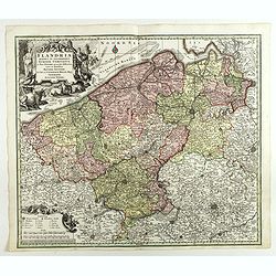
Flandria Maximus Et Pulcherrimus Europae Comitatus in suas Ditiones accurate distinctus. . .
A fine impression of this decorative map with its uncolored title cartouche, showing Flanders including the towns of Gent, Sluis, Bruges, Ostend, Brussels, Lille, Dunkerq...
Date: Augsbourg, 1730
Selling price: ????
Please login to see price!
Sold in 2018
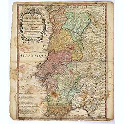
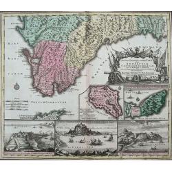
Regnum Portugalliae. . .
A detailed and uncommon map of Portugal and the Algarve, colored by provinces, showing towns, rivers, mountains, harbors, roads, etc. Embellished with a very large title ...
Date: Nuremberg, 1730
Selling price: ????
Please login to see price!
Sold in 2017
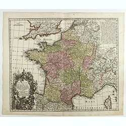
Le Royaume de France . . .
A finely engraved and decorative mid-18th century map published in Augsburg, Germany. This map shows France.Matthaus Seutter the elder first published his "Atlas Geo...
Date: Augsburg, c. 1730
Selling price: ????
Please login to see price!
Sold in 2018
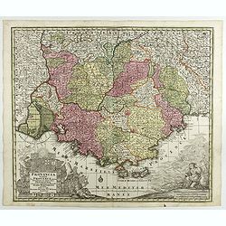
Provincia Gallis la Provence dicta..
Seutter's well-engraved map of southern France has two large decorative cartouche. Including the towns of Marseille, Toulouse, St.Tropez, Cannes, Antibes, etc.Matthaus Se...
Date: Nuremberg 1730
Selling price: ????
Please login to see price!
Sold in 2017
Mappa Geographica in qua Ducatus Lotharingiae...
Map of eastern France with the Alsace area, centered on Metz.Matthaus Seutter the elder first published his "Atlas Geographicus" in 1720 and added to the conten...
Date: Augsburg, 1730
Selling price: ????
Please login to see price!
Sold in 2017
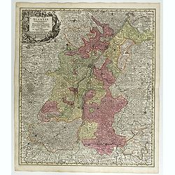
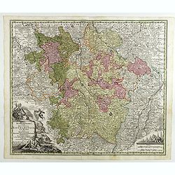
Alsatia Landgraviatus . . .
Map of eastern France centered on Strasburg and Basel in the South.Matthaus Seutter the elder first published his "Atlas Geographicus" in 1720 and added to the ...
Date: Augsburg, 1730
Selling price: ????
Please login to see price!
Sold in 2017
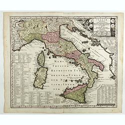
Italiae antique item insularum Siciliae, Sardiniae, Corsica . . .
Map of ancient Italy.Matthaus Seutter the elder first published his "Atlas Geographicus" in 1720 and added to the contents in subsequent editions under the titl...
Date: Augsburg, 1730
Selling price: ????
Please login to see price!
Sold in 2018
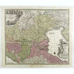
Regiae Celsitudinis Sabaudicae Status in quo Ducatus Sabaudiae Principat Pedemontium. . .
A nice example of Seutter's decorative map of the Savoy and Piedmont regions, in northern Italy, centered on Torino. The map coverage extends from Grenoble, Geneva, Die a...
Date: Augsburg, 1730
Selling price: ????
Please login to see price!
Sold in 2018
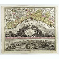
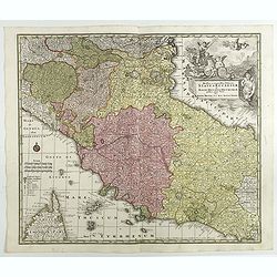
Lo Stato della Republica di Genova.
Decorative and detailed map of Republic of Genoa with a fine view of the harbor and city below. A numbered key identifies 64 buildings and locations. Matthaus Seutter the...
Date: Augsburg, 1730
Selling price: ????
Please login to see price!
Sold in 2018
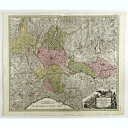
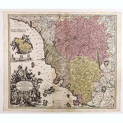
Ducatus Mediolanensis cum adjacentibus Principat. Et Dominiis. . .
Detailed map showing Lombardi with Lago Maggiore, Lake Lugano, Lake Como, Iseo-, Idro- and Lake Garda between Chiavenna, Trient, Modena, Genua, Asti and Brig.Matthaus Seu...
Date: Augsburg, 1730
Selling price: ????
Please login to see price!
Sold in 2018
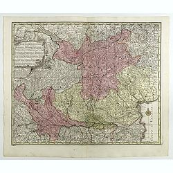
Tabula Geographica in qua integri Ducatus Mediolanensis. . .
Map of Milan region, extending to Venice.Matthaus Seutter the elder first published his "Atlas Geographicus" in 1720 and added to the contents in subsequent edi...
Date: Augsburg, 1730
Selling price: ????
Please login to see price!
Sold in 2018
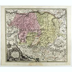
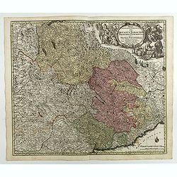
Ducatus Parmensis Et Placentinus. Ducatus Parmensis Et Placentinus. . .
Map of Parma region.Matthaus Seutter the elder first published his "Atlas Geographicus" in 1720 and added to the contents in subsequent editions under the title...
Date: Augsburg, 1730
Selling price: ????
Please login to see price!
Sold in 2018
Novissima et accuratior tabella magni ducatus Hetruriae complectens hodie tria territor. Florentinum, Pisanum et Senense cum insula Elba et locis quibusdam . . .
Scarce map of the region around Tuscany, Florence, Pisa, Siena end Elba Island, with a gorgeous cartouche.Matthaus Seutter the elder first published his "Atlas Geogr...
Date: Augsburg, 1730
Selling price: ????
Please login to see price!
Sold in 2017
Dominium Venetum . . .
Seutter's well-engraved map showing Venice, Verona, Cremona, Bergamo, etc. has a large decorative cartouche. Some boats offshore Venice. The map is in original wash color...
Date: Augsburg, 1730
Selling price: ????
Please login to see price!
Sold in 2018
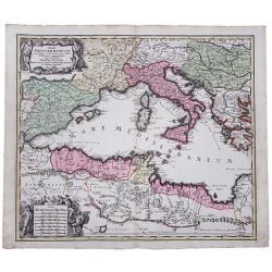
Novissima et accuratissima Delineatio Status Ecclesiae, et Magni Ducatus Hetruriae . . .
Striking map of Central Italy, from Mantua, Cremona, Piacenza and Ferrara in the north to Roma in the South and including Ancon on the Adriatic. Centered on Florence and ...
Date: Augsburg, 1730
Selling price: ????
Please login to see price!
Sold in 2017