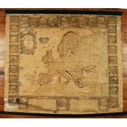
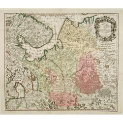
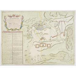
Browse Listings in Europe

Prospectus Celsissimi..
Engraved by Corvinus after a design of Salomon Kleiner. From Vera et accurata delineatio Omnium Templorum et Coenobiorum, Quae tam in Caesarrea Urbe ac Sede Vienna Austri...
Date: Augsburg, 1737
Selling price: ????
Please login to see price!
Sold in 2010
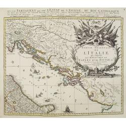
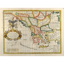
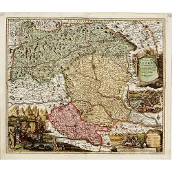
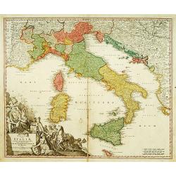
Partie orientale de L'Italie qui comprend les Royaumes de Naples et de Sicile. . .
Map of former Yugoslavia and the eastern part of Italy with a splendid baroque title cartouche with mythological figures. Title : Partie orientale de L'Italie qui compren...
Date: Amsterdam, ca. 1737
Selling price: ????
Please login to see price!
Sold in 2010
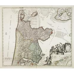
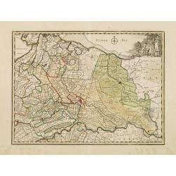
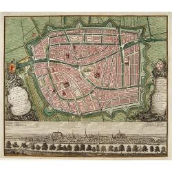
Hollandiae Septentrionalis & Frisiae Occidentalis. . .
Map of the Dutch region of North Holland between Amsterdam, Enkhuizen and Texel island. Large figurative cartouche and inset map of the islands Texel, Vlieland and Tersch...
Date: Amsterdam, ca. 1737
Selling price: ????
Please login to see price!
Sold in 2009
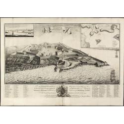
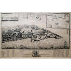
The Citadel of Plymouth.
Rare view of the Citadel of PlymouthA large and impressive copper engraved view of the Citadel of Plymouth, draw by Sandford Mace and engraved by Charles Mosley. Shows th...
Date: London, dated July 25th, July 1737
Selling price: ????
Please login to see price!
Sold in 2010
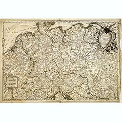
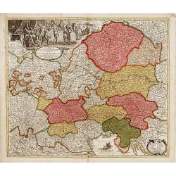
L'Allemagne et ses frontieres comprenant le theatre de la guerre. . .
A scarce map of Germany, Poland, The Low Countries, Switzerland, Austria, Northern Italy, etc. showing the Theater of War in the Holy Roman Empire.
Date: Paris, 1737
Selling price: ????
Please login to see price!
Sold in 2014
The Citadel Of Plymouth.
A magnificent panoramic view of the citadel at Plymouth which was built in 1665. The view is dedicated to the "Hon. Charles Churchill Esqr. Major General Of His Maje...
Date: London, 1737
Selling price: ????
Please login to see price!
Sold in 2014
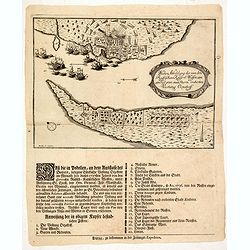
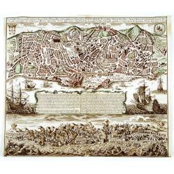
Wahre abbildung der von den Russischen keijserl: Waffen am 13 Jul: 1737 mit Sturm eroberten Vestung Oczakoff.
Rare broadsheet with an expertly engraved plan (210 x 290mm.) of the Russian siege of Oczaków at 13 July 1737. Turkish vessels in the Black Sea leaving the town.In lower...
Date: Leipzig, 1737
Selling price: ????
Please login to see price!
Sold in 2014
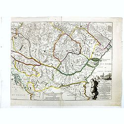
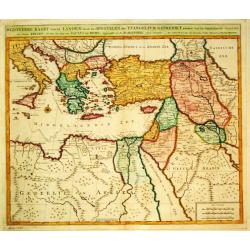
Le théâtre de la guerre sur les frontières des deux empires depuis Vienne jusques à Constantinople, où se trouvent la Hongrie, la Transilvanie,
Nicolas De Fer's map of the Theater of War showing the region between Vienna and Constantinople, included are Hungary, Bulgaria, Wallachia, Transylvania, Bosnia and Serbi...
Date: Paris, Bernard, 1737
Selling price: ????
Please login to see price!
Sold in 2019
![Afbeelding der vesting Tionningen.. [Two prints]](/uploads/cache/12575-250x250.jpg)
Afbeelding der vesting Tionningen.. [Two prints]
Attractive map and a panoramic view of the siege of Tonnigen, published in "Kleyne en Beknopte Atlas, of Tooneel des Oorlogs in Europa..".The atlas was publishe...
Date: Amsterdam 1738
Selling price: ????
Please login to see price!
Sold
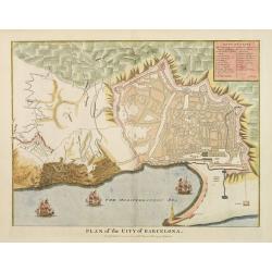
Plan of the City of Barcelona
From Rapin's History of England , a nicely detailed plan of Barcelona, the capital of Catalonia. The plate contains a 19 point legend and the presentation is enhanced wit...
Date: London c.1738
Selling price: ????
Please login to see price!
Sold
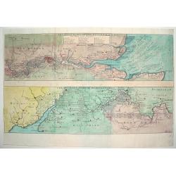
THE EAST PART OF THE RIVER THAMES / THE WEST PART OF THE RIVER THAMES
An attractive and detailed map of the River Thames. The top portion of the work focuses on the eastern end of the river, highlighting London and directly west. The lower ...
Date: London, ca. 1738
Selling price: ????
Please login to see price!
Sold
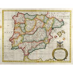
A New Map of Present Spain & Portugal
Decorative colored map of Spain and Portugal with parts of France, the northern part of Africa and the Balearic Islands. From "A New Sett of Maps both of Antient an...
Date: London, 1738
Selling price: ????
Please login to see price!
Sold in 2012
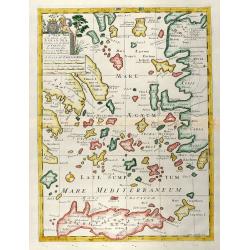
A New Map of the Islands of the Aegaean Sea, together with the Island of Crete, and the Adjoining Isles
Decorative colored map of the Aegean Sea with Crete and the western part of Turkey. From "A New Sett of Maps both of Antient and Present Geography" by Edward W...
Date: London, 1738
Selling price: ????
Please login to see price!
Sold in 2009
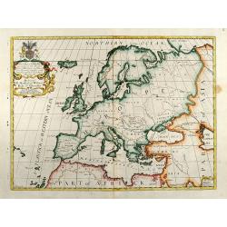
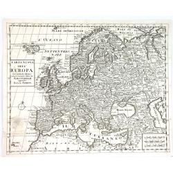
A New Map of Europe according to the Present General Divisions and Names
Decorative colored map of the European continent. From "A New Sett of Maps both of Antient and Present Geography" by Edward Wells an English clergyman, teacher...
Date: London, 1738
Selling price: ????
Please login to see price!
Sold in 2009
A New Map of Turky in Europe, And Parts of adjoyning
Decorative colored map of Greece, the Balkans and the Western part of Turkey. From "A New Sett of Maps both of Antient and Present Geography" by Edward Wells a...
Date: London, 1738
Selling price: ????
Please login to see price!
Sold in 2009
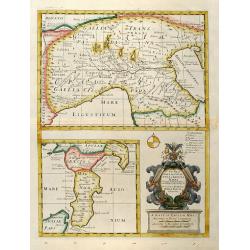
A New Map of Gallia Cisalpina & Graecia Magna
Decorative colored map of Northern Italy in the upper part and beneath this South Italy with parts of Sicily. With a beautiful unusual cartouche. From "A New Sett of...
Date: London, 1738
Selling price: ????
Please login to see price!
Sold in 2013
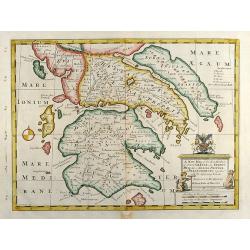
A New Map of the So. & Mid Parts of Antient Greece viz. Epirus, Hellas, or Graecia Propria, and Peloponnesus, together with Adjoyning Islands
Decorative colored map of the Peloponnese (Morea) in Greece. From "A New Sett of Maps both of Antient and Present Geography" by Edward Wells an English clergym...
Date: London, 1738
Selling price: ????
Please login to see price!
Sold in 2010
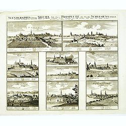
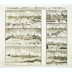
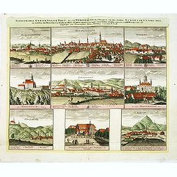
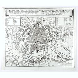
Scenographia Urbium Silesiae, Tab I. / Prospect der Stadte Schlesiens I. Tabell. . . Oels und Brieg. . .
Eight panoramic town-views of Oels and Brieg on one sheet. After a design by the Prussian artist Friedrich Bernhard Werner (1690-1778) and published by Homann's heirs. Un...
Date: Nuremberg, c. 1738
Selling price: ????
Please login to see price!
Sold in 2012
Scenographia Urbium Silesiae, Tab III. / Prospect der Stadte Schlesiens III. Tabell. . . Fürstenth Wohlau. . .
Seven panoramic town-views of Wohlau on one sheet. After a design by the Prussian artist Friedrich Bernhard Werner (1690-1778) and published by Homann's heirs. Underneath...
Date: Nuremberg, c. 1738
Selling price: ????
Please login to see price!
Sold in 2012
Scenographia Urbium Silesiae, Tab II. / Prospect der Stadte Schlesiens II. Tabell. . . Breslaw und Sagan. . .
Seven panoramic town-views of Breslau and Sagan on one sheet. After a design by the Prussian artist Friedrich Bernhard Werner (1690-1778) and published by Homann's heirs....
Date: Nuremberg, c. 1738
Selling price: ????
Please login to see price!
Sold in 2012
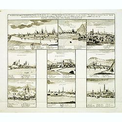
Scenographia Urbium Silesiae, Tab IV. / Prospect der Stadte Schlesiens Vierte Tabell. . . Neise. . .
Eight panoramic town-views of Neise on one sheet. After a design by the Prussian artist Friedrich Bernhard Werner (1690-1778) and published by Homann's heirs. Underneath ...
Date: Nuremberg, c. 1738
Selling price: ????
Please login to see price!
Sold in 2012
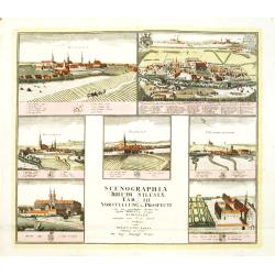
Scenographia Urbium Silesiae, Tab V. / Vorstellung der Prospecte . . . Liegnitz und Teschen . . .
Seven panoramic town-views of Liegnitz and Teschen on one sheet. After a design by the Prussian artist Friedrich Bernhard Werner (1690-1778) and published by Homann's hei...
Date: Nuremberg, c. 1738
Selling price: ????
Please login to see price!
Sold in 2012
Scenographia Urbium Silesiae, Tab IV. / Prospect der Stadte Schlesiens Sechste Tabell. . . Schweidnitz. . .
Eight panoramic town-views of Schweidnitz on one sheet. After a design by the Prussian artist Friedrich Bernhard Werner (1690-1778) and published by Homann's heirs. Under...
Date: Nuremberg, c. 1738
Selling price: ????
Please login to see price!
Sold in 2012
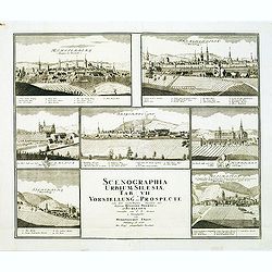
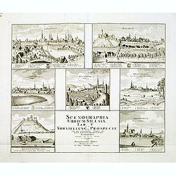
Scenographia Urbium Silesiae, Tab VII. / Vorstellung der Prospecte . . . Munsterb Jaegerend . . .
Seven panoramic town-views of Liegnitz and Munsterb Jaegerend on one sheet. After a design by the Prussian artist Friedrich Bernhard Werner (1690-1778) and published by H...
Date: Nuremberg, c. 1738
Selling price: ????
Please login to see price!
Sold in 2012
![Scenographia Urbium Silesiae, Tab [V] II. / Vorstellung der Prospecte . . . Munsterb Jaegerend . . .](/uploads/cache/33747-250x250.jpg)
Scenographia Urbium Silesiae, Tab [V] II. / Vorstellung der Prospecte . . . Munsterb Jaegerend . . .
Seven panoramic town-views of Liegnitz and Munsterb Jaegerend on one sheet. After a design by the Prussian artist Friedrich Bernhard Werner (1690-1778) and published by H...
Date: Nuremberg, after 1738
Selling price: ????
Please login to see price!
Sold in 2014
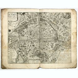
Traité de la Police. (8 plans of Paris).
Set of eight city plans of Paris, each map showing Paris from the time of Julius Caesar to Paris in 1705. The plate volume of Nicolas Delamare’s "La Traité de la ...
Date: Paris, 1705-1738
Selling price: ????
Please login to see price!
Sold
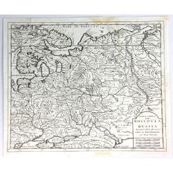
Nuova Carta della Moscovia o Russia.
A finely engraved map of European Russia with details of cities, towns, forests and topography, by Albrizzi, after Isaak Tirion (1705–1765) who was an 18th-century publ...
Date: Venice, 1738
Selling price: ????
Please login to see price!
Sold in 2018
Carta Nuova Dell' Europa....
Map taken from "Atlas Novissimo" published by Giambattista Albrizzi in 1738. Later included in the "History of all peoples of the world" published in ...
Date: Venice, 1738
Selling price: ????
Please login to see price!
Sold in 2016
Accurata Repraesentatio ichnographica Urbis Episcopalis in Ducatu Lotharingiae, dictae Metae, antiquis Divodorum Mediomatricorum . . .
Map of Metz after a design of W. Zollmann.
Date: Nuremberg, 1738
Selling price: ????
Please login to see price!
Sold in 2021
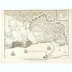
Plan of the City of Barcelona.
From Rapin's History of England , a nicely detailed plan of Barcelona, the capital of Catalonia. The plate contains a 19 point legend and the presentation is enhanced wit...
Date: London, c.1738
Selling price: ????
Please login to see price!
Sold in 2020
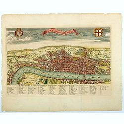
A View of London about the Year 1560.
Published as the frontispiece to Maitland's well recognized HISTORY OF LONDON, this is a sought after, handsome and finely engraved bird's-eye view / plan of Elizabethan ...
Date: London, ca 1738
Selling price: ????
Please login to see price!
Sold in 2021
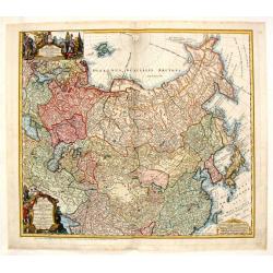
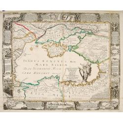
Imperii Russici et Tatariae Universae.
Finely engraved map of Greater Russia, from the Baltic, across Siberia to Kamchatka, with Japan, Korea, and the Greater portion of China. Very elaborate cartouche with be...
Date: Nuremberg, 1739
Selling price: ????
Please login to see price!
Sold in 2013
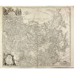
Tartariae Maioris sive Asiaticae Tabula..
This antique map shows the "Russian Tartary" and as well the "Asian Tartary".With title cartouche in the lower left corner, another title cartouche wi...
Date: Nuremberg, 1739
Selling price: ????
Please login to see price!
Sold
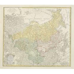
Imperii Russici et Tatariae Universae tam majoris et Asiaticae quam minoris et Europaeae Tabula.
Finely engraved and very detailed map of the Russian Empire covering the region from the Baltic Sea across Siberia up to Japan. The a decorative cartouche contains hunter...
Date: Nuremberg, 1739
Selling price: ????
Please login to see price!
Sold in 2010
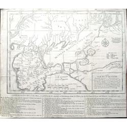
An exact map of the CRIM (Formely Taurica Chersonesus) Part of Lesser Tartary, the Sea of Asoph, and the adjacent Country of the Kuban Tartars. . .
Detailed and handsome wood block printed map centered on the Sea of Azov detailing the ongoing war between the Russians and Turks. The map is filled troop locations and b...
Date: London, 1739
Selling price: ????
Please login to see price!
Sold in 2010
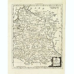
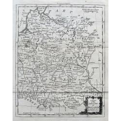
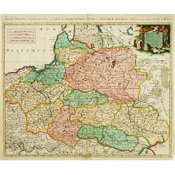
A map of the eastern map of Poland. . .
Drawn by Thomas Kitchin and published in the London Magazine. Cities, towns and geographical features are all shown. Department boundaries within Poland are marked with d...
Date: London, 1739
Selling price: ????
Please login to see price!
Sold in 2012
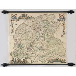
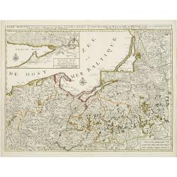
Nieuwe caert van Frieslant vermeerdert en verbetert op ordre en Gedeputeerde Staten door Bernard Schotanus à Sterringa vervaardigd en verbeterd door Johan Vegelin van Claerenbergen.
This very decorative wallmap - the so-called 'Vegelin-map' - is showing the Friesland counties, Oostergo, Westergo and Zevenwolden. The map is embellished with the coats ...
Date: Amsterdam, 1739
Selling price: ????
Please login to see price!
Sold
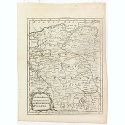
A new map of the western part of the Kingdom of Poland.
Drawn by Thomas Kitchin and published in the London Magazine. Cities, towns and geographical features are all shown. Department boundaries within Poland are marked with d...
Date: London, 1739
Selling price: ????
Please login to see price!
Sold in 2016
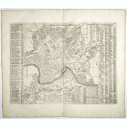
Rome Ancienne et Moderne.
Fine plan of ancient Rome with extensive key to principal buildings in town, from the most remarkable Atlas Historique et Méthodique published by L'Honore & Chatelai...
Date: Amsterdam, 1705-1739
Selling price: ????
Please login to see price!
Sold in 2020
A Map of the Eastern Part of Poland.
A seldom-seen small map of parts of today's Poland, Lithuania, Latvia, Belarus, and Ukraine.
Date: London, ca. 1739
Selling price: ????
Please login to see price!
Sold in 2017

Stanislao Leczinski Re di Polonia, Gran Duca di Lituania.
Portrait of Stanislaw I Leszczynski ( 20 October 1677 – 23 February 1766) was King of Poland, Grand Duke of Lithuania, Duke of Lorraine and a count of the Holy Roman Em...
Date: Venice, 1739
Selling price: ????
Please login to see price!
Sold in 2022
![[Untitled Martime Chart.]](/uploads/cache/43629-250x250.jpg)
[Untitled Martime Chart.]
One double page maritime chart from John Pine's Tapestry hangings of the House of Lords Representing the Engagements between the English and Spanish Fleets in the year 15...
Date: London, 1739
Selling price: ????
Please login to see price!
Sold in 2023
An Exact Map of the Crimea. . .
A fascinating map of the Crimea, the Sea of Azov and Lesser Tartary, illustrating the Russian and Turkish conflict in the region. The map is filled with troop locations a...
Date: London, 1739
Selling price: ????
Please login to see price!
Sold in 2019
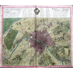
Carte Topographique des Environs & du Plan de Paris levée par Msr. l'Abbé Delagrive & copiée selon l'original Parisien. . .
An unusual plan of old Paris, based on Abbé Jean Delagrive's map of 1738. In the map many of today's city districts appear as villages. Highly detailed, showing the terr...
Date: Nuremberg, 1739
Selling price: ????
Please login to see price!
Sold in 2019
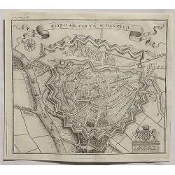
Piano della Citta di Danzica._
A fine copper engraved bird’s eye view shows Gdansk in Poland. From T. Salmon's "Lo stato presente di tutti i paesi e popoli del mondo ...". Published in Ven...
Date: Venice, 1739
Selling price: ????
Please login to see price!
Sold in 2020
Uitrecht
Detailed map of the province of Utrecht. Including Amsterdam, Naarden, Amersfoort, Rhenen and Gouda. Fine title cartouche of Bishop and agricultural scenes.
Date: Amsterdam 1740
Selling price: ????
Please login to see price!
Sold
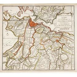
Nieuwe en Accurate Kaart van de Balluage van Amstelland.
Detailed map of the area south east of Amsterdam, including river Vecht and Muiden, Weesp, Loenen and Mijdrecht.
Date: Amsterdam 1740
Selling price: ????
Please login to see price!
Sold
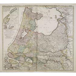
Hollandiae comitatus una cum Ultrajectino Dominio nec non maximis partibus Geldriae Ducatus / per C. Specht. . .
Scarce map of the center of the Low Countries, with the provinces North and South Holland in full contemporary body colors, with inset map of Texel and Vlieland in upper ...
Date: Amsterdam, 1740
Selling price: ????
Please login to see price!
Sold in 2020
Lisabona magnisicentissima..Portugalliae..
A most decorative bird's-eye view of Lisbon.
Date: Augsburg 1740
Selling price: ????
Please login to see price!
Sold
Plan dela Ville Academique et marchande de Leyden en Hollande..
Rare bird's-eye view of the town. At bottom detailed panoramic view with key.
Date: Augsburg 1740
Selling price: ????
Please login to see price!
Sold
Ducatus Stiriae novissima Tabula.
"Showing Stiria in Austria, centered on Grütz, with to the right an inset with a bids-eye view of the town. Lower left and right splendid cartouches The car...
Date: Nurenberg 1740
Selling price: ????
Please login to see price!
Sold
Leopolda Magni.. Germaniae Austriacae generalum..
Fine map of Austria and adjacting countries.Johann Baptist Homann born in Kammlach (1663). He was engraver, map-seller and geographer to the Kaiser of the Holy Roman Empi...
Date: Nurenberg 1740
Selling price: ????
Please login to see price!
Sold
Estats de Pologne subdivises suivants les..
Decorative and detailed map of Poland, with tip of the Black Sea lower right. Prepared by Sanson, but published in Amsterdam by Petrus Schenk.
Date: Amsterdam 1740
Selling price: ????
Please login to see price!
Sold
Trevirensis Archi-Episcopatus et Electoratus
Map of the south-west part of Germany with one decorative figure cartouche.
Date: Augsburg 1740
Selling price: ????
Please login to see price!
Sold
Statuum totius Italiae.. Siciliae Sardiniae..
Johann Baptist Homann's well-engraved map of Italy, Sardinia, Corsica, Malta and Sicily has a large decorative cartouche with portrait of Pope Clemens XI..Johann Baptist ...
Date: Nuremberg 1740
Selling price: ????
Please login to see price!
Sold
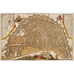
Plan tres exact de la fameuse ville marchande d'Amsterdam..
Uncommon large scale plan of Amsterdam, with a key (A-X, 1-93) in upper right corner. and a key (94-139) and a map of the region of Amsterdam in upper left corner. In the...
Date: Amsterdam 1740
Selling price: ????
Please login to see price!
Sold
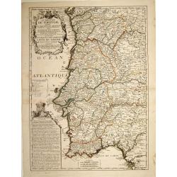
Le Royaume de Portugal divisé en cinq grandes provinces. . .
RARE map of Portugal. A visually stunning map with a large title cartouche. A second text box with a geographical description of Portugal, with the coat of arms.Nolin mus...
Date: Paris, 1740
Selling price: ????
Please login to see price!
Sold in 2023
L'Europe dressé sur les nouvelles..
Separataly published: very scarce. A decorative wall map embellished by 30 panel vignettes illustrating episodes in the history of Europe. Many of the vignettes have exce...
Date: Paris 1740
Selling price: ????
Please login to see price!
Sold
Mappae Imperii Moscovitici pars Septentrionalis..
Detailed map of northern Russia embellished with an uncolored pictorial cartouche showing hunting scenes.Prepared by de l'Isle.
Date: Augsburg 1740
Selling price: ????
Please login to see price!
Sold
Plan der Bataille bey Stovutschane in der Moldau ..
Rare plan of a siege between the Russian army and the German and Turkish armies. Texts in German and Russian.
Date: Germany 1740
Selling price: ????
Please login to see price!
Sold
![[Attractive Manuscript Plan of the Village of Prusy (Prauss), Strzelin (Strehlen) County, near Wrocław (Breslau)]](/uploads/cache/35784-250x250.jpg)
[Attractive Manuscript Plan of the Village of Prusy (Prauss), Strzelin (Strehlen) County, near Wrocław (Breslau)]
Attractive manuscript map of the village of Prusy (Prauss), Strzelin (Strehlen) County, near Wrocław (Breslau) and coat of arms of Graf Zierotin - Freiherr von L...
Date: c.1740
Selling price: ????
Please login to see price!
Sold in 2015
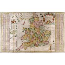
The South Part of Great Britain called England and Wales...
Full Title: The South Part of Great Britain called England and Wales. Containing all the Cities, Market Towns, Boroughs and whatever Places have the Election of Members o...
Date: London, c. 1740
Selling price: ????
Please login to see price!
Sold
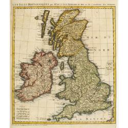
Les Isles Britanniques par Mr. De L'Isle. Geographe du Roy &c.
Uncommon map of the British Isles.
Date: Paris, c.1740
Selling price: ????
Please login to see price!
Sold
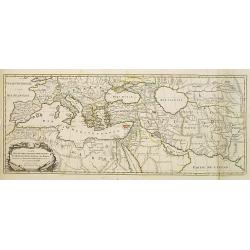
Carte Des Quatre Grandes Monarchies, des Assirieens, des Perse, des Grecs, et des Romains.. Celle Flavius Joseph .
Map covering the entire Mediterranean Basin and the Middle East as far as the borders of India. Outline coloring shows the political division.
Date: Amsterdam 1740
Selling price: ????
Please login to see price!
Sold
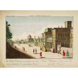
GENUA - Pallais Villamena a Gene avec son agreable Prospecte.
A well-known publisher of optical prints, established in Augsburg. In the eighteenth and nineteenth centuries there were many popular speciality establishments in Paris, ...
Date: Augsburg, 1740
Selling price: ????
Please login to see price!
Sold in 2014
Nova et accurata Tartariae Europae.. Crimeae..
Very rare carte-a-figure map of the Black Sea area. With decorative title cartouche and surrounded by four borders with 10 city views each accompanied by large descriptiv...
Date: Augsburg 1740
Selling price: ????
Please login to see price!
Sold
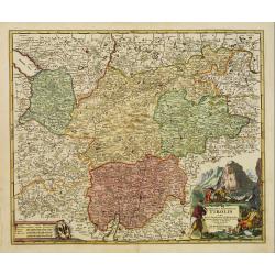
Comitatus Principalis Tirolis..
Very fine and detailed map of Tyrol, covering the towns of Kuffstein, Innsbruck, western part of Boden See, and as far south as tip of Lake Garda with the Italian area Tr...
Date: Nuremberg 1740
Selling price: ????
Please login to see price!
Sold in 2009
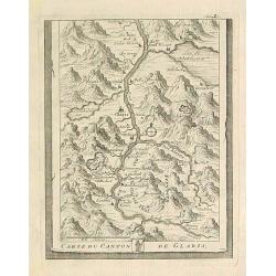
Carte du Canton de Glaris.
From Delice de la Suisse . Including Wallen See.
Date: Austria 1740
Selling price: ????
Please login to see price!
Sold
BRABANT
The Homann-family became the most important editors of atlases in Germany during the 18th. century. This map of Brabant shows the quarters: Louvain, Brussels, Antwerp, s...
Date: Nurnberg ca.1740
Selling price: ????
Please login to see price!
Sold
Regnorum Siciliae et Sardiniae.. Melitae seu Maltae ..
Johann Baptist Homann's well-engraved map of Sicily, Sardinia and Malta has a large decorative title cartouche.With ships in the sea and an inset of Valetta in lower righ...
Date: Nuremberg 1740
Selling price: ????
Please login to see price!
Sold
Byzondere Kaart van de Landen daar de Apostelen het Evangelium Gepredikt hebben?en van de weg van Paulus naar Rome.
A map of the eastern Mediterranean. With the track of St. Paul\'s voyage from Cesaere to Rome. From \' Hisoire du Vieux et du Nouveau Testament\', published by Johannes C...
Date: Amsterdam, c. 1740
Selling price: ????
Please login to see price!
Sold
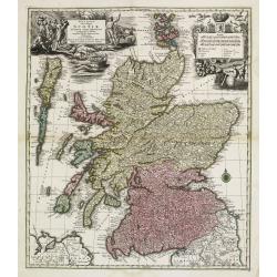
Nova et accurata totius Regni Scotiae, Secundum Omnes Provincias et adjacentes Insulas..
Fully and strongly engraved copper plate map that includes all of Scotland and the New Hebrides, here called the Western Iles of Scotland. The map is filled with minute d...
Date: Augsburg 1740
Selling price: ????
Please login to see price!
Sold
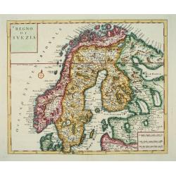
Nuova Carta del Regno di Svezia...
An attractive map of Scandinavia.Albrizzi was the first publisher to issue Tirion's maps: Tirion's own atlas was issued in Amsterdam in 1744.
Date: Venice, Albrizzi, 1740
Selling price: ????
Please login to see price!
Sold
Regni Borussiae.. Royaume de Prusse..
Rare map of Prussia, with inset map of the area around Koningsberg.RARE.
Date: Amsterdam, 1740
Selling price: ????
Please login to see price!
Sold
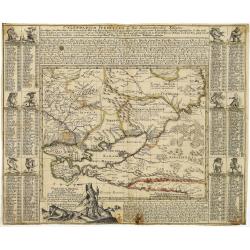
Tartaria Minor. . . . Calendarium Perpetuum oder Ein Immerwährender Kalender. . .
Very rare map of the Crimea and Ukraine, surrounded by a Calendarium Perpetuum. Each month is represented in a block with the the days and its Saint and topped with a dwa...
Date: Augsburg, 1740
Selling price: ????
Please login to see price!
Sold in 2025
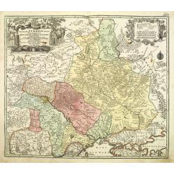
Amplissima Ucraniae Regio Palatinatus Kioviensem et Braclaviensem . . .
An uncommon and attractive map of the Ukraine has excellent detail of the river systems and charming, pictorial topography. It is decorated with two elegantly engraved ca...
Date: Augsburg, 1740
Selling price: ????
Please login to see price!
Sold in 2011
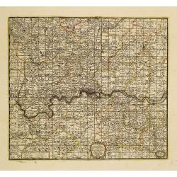
A New Map Containing the Towns Gentlemens Houses Villages and other Remarks Round London . . .
Detailed map showing hundreds of place names in the greater London area, including Darking, Hampsted, Hertford, Guildford, etc.
Date: London, 1740
Selling price: ????
Please login to see price!
Sold in 2011
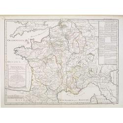
Franciae status sub regibus primae stirpis,. . ./ Etat de la France sous les rois de la première race. . .
A historical map of France depicting the region at the beginning of the Middle Ages. It depicts the kingdom of Clovis, the Founder of France, as it was divided among his ...
Date: Paris, 1740
Selling price: ????
Please login to see price!
Sold
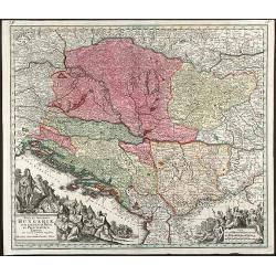
Nova et Accurata Hungariae cum adiacentib. Regn. et Principatibus Tabula
Original old colored map of the Balkan by M. Seutter. Showing Hungary, Serbia, Croatia, Bosnia and Herzegovina and Albania. With two beautiful cartouches.
Date: Augsburg, 1740
Selling price: ????
Please login to see price!
Sold in 2009
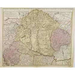
Carte particuliere de la Hungarie de la Transivanie de la Croatie et de la Sclavonie. . .
A map showing Hungary, Serbia, Croatia.
Date: Amsterdam, 1740
Selling price: ????
Please login to see price!
Sold in 2008