Browse Listings in Europe
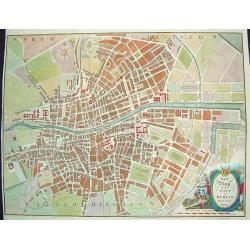
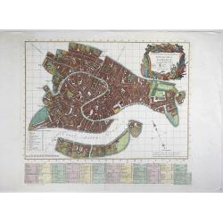
New Map of the City of Dublin For the Year 1816
A hard to find, beautifully rendered plan of Dublin. The work contains wonderful detail, with all streets, major sites and expanses identified. In the lower right corner ...
Date: Dublin, ca. 1816
Selling price: ????
Please login to see price!
Sold in 2009
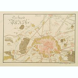
Die Gegend um Paris.
Very detailed manuscript plan in pen and ink with water color of Paris and it immediate environs. Singed with brown ink: "Christian Laugart (1)816 ".
Date: Paris, 1816
Selling price: ????
Please login to see price!
Sold in 2008
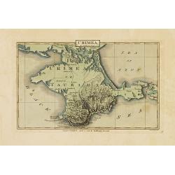
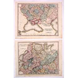
Crimea.
Map of Crimea, island border by Black Sea and sea of Azof. Published in J.Luffman's Geographical and Topographical Atlas.Steel engraved plate by Neele.
Date: London, 1815-1816
Selling price: ????
Please login to see price!
Sold in 2012
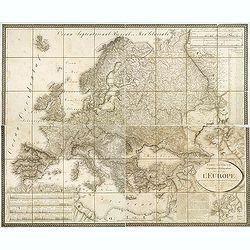
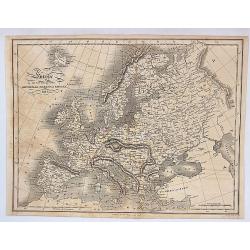
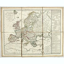
Carte générale Orographique et Hydrographique de l'Europe, qui montre les principales ramifications des montagnes, fleuves, et chemins. . .
Napoleonic folding map of Europe prepared by Général Baron Sorriot de L'Host ( 1767-1831) and engraved by Joseph List, active in Vienna (1805-1835).The map shows the ri...
Date: Vienna, 1816
Selling price: ????
Please login to see price!
Sold in 2013
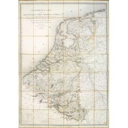
Algemeene kaart van het Koningryk der Nederlanden, zynde, voor zoo verre de schaal zulks gedoogt, eene itineraire van dezen Staat uit de laatste naauwkeurige driehoeks metingen en de beste topographische stukken zamengesteld. . .
According to Koeman: "Onmiddelijk na de vereniging van de Noordelijke en Zuidelijke Nederlanden verschenen er overzichtskaarten van deze nieuwe staat: eerst nog met ...
Date: The Hague, 1816
Selling price: ????
Please login to see price!
Sold in 2017
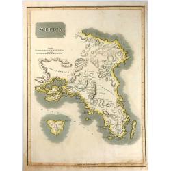
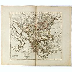
Attica.
An attractive map of Attica, in Greece. It features many of the important cities from early Greek History including: Athens, the Plain of Marathon, Salamis, and the islan...
Date: Edinburgh, 1816
Selling price: ????
Please login to see price!
Sold in 2016
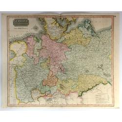
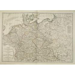
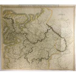
Germany, North of the Mayne.
A fine hand colored 1816 map depicting the semi-autonomous kingdoms, duchies, and Prussian territories of northern Germany. These include: Westphalia, Rhineland, Saxony, ...
Date: Edinburgh, 1816
Selling price: ????
Please login to see price!
Sold in 2018
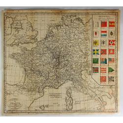
Carte de France et Pays Limitiophies avec les Divisions d'Apres les Derniers Tiaites.
An uncommon map of France and Italy with parts of Great Britain, Spain and Germany. The best of the map is the "Pavillons" insert featuring twenty finely colore...
Date: Paris, 1816
Selling price: ????
Please login to see price!
Sold in 2022
Europe According to the General Treaty of Vienna, 1815.
A detailed map of Europe showing the lands and countries covered under the Treaty of Vienna signed in 1815. Published in Leeds, England by Edward Baines in 1816. Engrave...
Date: Leeds, 1816
Selling price: ????
Please login to see price!
Sold in 2017
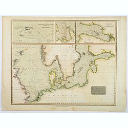
Chart of the North and Baltic Seas &c.
A detailed sea chart of the North Sea & Baltic Sea by John Thomson, the Edinburgh cartographer. This highly detailed chart features soundings, shoals, fishing banks a...
Date: Edinburgh, 1816
Selling price: ????
Please login to see price!
Sold in 2020
![Untitled. [Chart of Zeeland extending as far as Hellevoetsluis]](/uploads/cache/23504-250x250.jpg)
Untitled. [Chart of Zeeland extending as far as Hellevoetsluis]
Right sheet of a 3 sheets, very detailed chart. This half illustrates the seacoast extending from Terneuzen to Hellevoetsluis in the Netherlands.Showing towns, banks and ...
Date: Paris, 1817
Selling price: ????
Please login to see price!
Sold in 2009
L'Italie dressée sur les observations de l'académie des sciences. . .
Very interesting map of Italy, including Sardinia, Corsica and Sicily. Buache drew heavenly on the work of Delisle. This edition updated for 1817.Philippe Buache de la Ne...
Date: Paris, 1817
Selling price: ????
Please login to see price!
Sold
Carte réduite des côtes des Pays-Bas.
repaired by Beautemps-Beaupreé. Covering the coast from Oostende till Hellevoetssluis. Giving exquisite detail with soundings. Upper left large advertisement, upper rig...
Date: Paris, 1817
Selling price: ????
Please login to see price!
Sold in 2013
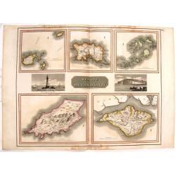
Remote British Islands.
Large, hand-colored map of Great Britain's remote islands including Wight, Scilly, Mann, Guernsey & Jersey. There are also two fine engravings of island scenes.
Date: Edinburgh, 1817
Selling price: ????
Please login to see price!
Sold in 2016
Russia In Europe - North Part & South Part (Two Maps).
Two fine hand-colored maps of Russia with excellent detail. (North and South Part) The mapmaker was Arrowsmith and they were engraved by Sidney Hall in London in 1817.
Date: London, 1817
Selling price: ????
Please login to see price!
Sold in 2014
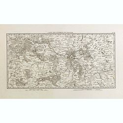
Carte des environs de Polotsk.
Very detailed map taken from the atlas part of the rare work "Mémoires pour servir à L'Histoire de la Guerre entre la France et la Russie, en 1812". Guillaume...
Date: Paris, Barrois L'Aine, 1817
Selling price: ????
Please login to see price!
Sold in 2015
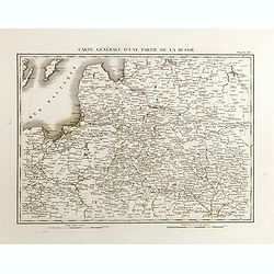
Carte générale d'une partie de la Russie.
Detailed map showing a part of Russia taken from the atlas part of the rare work "Mémoires pour servir à L'Histoire de la Guerre entre la France et la Russie, en 1...
Date: Paris, Barrois L'Aine, 1817
Selling price: ????
Please login to see price!
Sold in 2015
The Netherlands.
Striking large hand-colored map of The Netherlands. From John Thomson's "New General Atlas",/b> published in 1817. Engraved by J. Moffat.
Date: Edinburgh, 1817
Selling price: ????
Please login to see price!
Sold in 2018
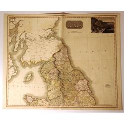
Northern Part of England.
Handsome hand colored map of Northern England, extending as far south as Anglesey. Inset view of ‘The Rope Bridge between the Islands of Holyhead and Anglesey’ at top...
Date: Edinbugh. 1817
Selling price: ????
Please login to see price!
Sold in 2017
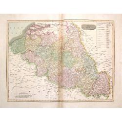
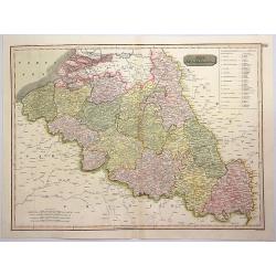
The Netherlands (Belgium and Luxemburg)
A fine map of Belgium and Luxembourg by John Thomson, the Edinburgh cartographer. The title ‘The Netherlands’ refers to the old name for Belgium. The map covers the r...
Date: Edinbourgh, 1817
Selling price: ????
Please login to see price!
Sold in 2016
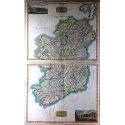
Northern Part of Ireland & Southern Part of Ireland (2 Parts)
This is a striking set of maps of Ireland. Published by John Thomson in Edinburgh in 1817. Essentially two separate maps, the first map (image top) depicts Northern Irela...
Date: Edinburgh, 1817
Selling price: ????
Please login to see price!
Sold in 2016
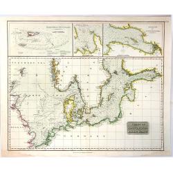
Chart of the North and Baltic Seas
A detailed sea chart of the North Sea & Baltic Sea by John Thomson, the Edinburgh cartographer. This highly detailed chart features soundings, shoals, fishing banks ...
Date: Edinbourgh, 1817
Selling price: ????
Please login to see price!
Sold in 2019

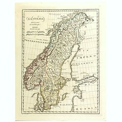
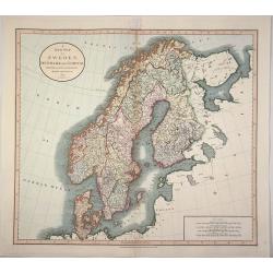
Scandinavia, or Sweden, Denmark & Norway
This fine hand colored map of Scandinavia depicts Sweden, Denmark, and Norway and Finland which was part of Sweden. The map is beautifully engraved in the minimalist Engl...
Date: Edinbourgh, 1817
Selling price: ????
Please login to see price!
Sold in 2016
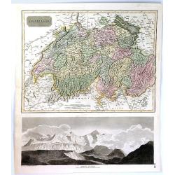
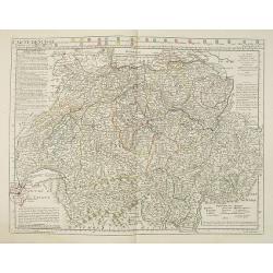
Swisserland
A fine map of Switzerland by John Thomson in 1817. It is divided into two parts, the top part of the sheet covers the Helvetic Confederation of Switzerland, as divided in...
Date: Edinbourgh, 1817
Selling price: ????
Please login to see price!
Sold in 2019
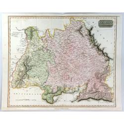
Germany South of the Maine.
A fine map of southern Germany published in Edinburgh in 1817 in Thomson's “New General Atlas”.It is an interesting large format copper engraved antique map of the ea...
Date: Edinbourgh, 1817
Selling price: ????
Please login to see price!
Sold in 2020
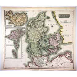
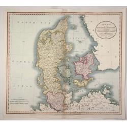
Denmark, Iceland & Feroe Islands.
Very pleasing large engraved map of Denmark by Joun Johnson in Edinbourg in 1817. Features inserts of Iceland and Feroe Islands. John Thomson (1777-1840), was a Scottish...
Date: Edinbourgh, 1817
Selling price: ????
Please login to see price!
Sold in 2017
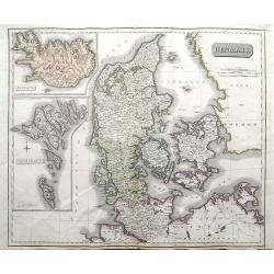
Denmark; Iceland; Feroe Islands.
A double page map of Denmark with inset maps of Iceland and the Faroe Islands.
Date: Edinburgh, 1817
Selling price: ????
Please login to see price!
Sold in 2020
The Netherlands.
A pleasing hand colored 1817 map of Holland by Thomson, engraved in the minimalist English style of the early part of the 19th century. Relief is shown by hachure with to...
Date: Edinbourgh, 1817
Selling price: ????
Please login to see price!
Sold in 2019
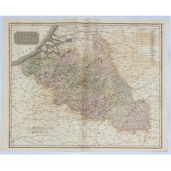
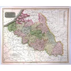
Belgium or the Netherlands.
A striking 1817 map of Belgium and Luxembourg by the Edinburgh cartographer John Thomson. The title ‘The Netherlands’ refers to the old name for Belgium covering the ...
Date: Edinbourgh, 1817
Selling price: ????
Please login to see price!
Sold in 2018
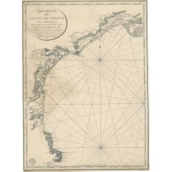
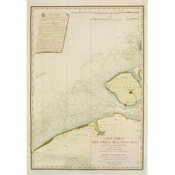
Carte réduite des côtes de France sur la Méditerranée
This masterful and attractive sea chart of the southern coast of France was created by order of the King of France for the Royal Nautical Depository (Dépôt), and bears ...
Date: Paris, 1817
Selling price: ????
Please login to see price!
Sold in 2023
Carte de Suise ou sont les Cantos de Zurich Berne . . .
Very interesting map of Switzerland, colored in outline. Along the top 26 coats of arms of the diverent cantons. Buache drew heavenly on the work of Delisle. This edition...
Date: Paris, 1818
Selling price: ????
Please login to see price!
Sold
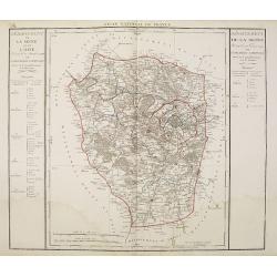
Departement de la Seine et de l'Oise.
Detailed map centered on Paris. Taken from "Atlas national de France", the first atlas with the departments of France published by Pierre Grégoire Chanlaire.
Date: Paris, P.G. Chanlaire, 1818
Selling price: ????
Please login to see price!
Sold
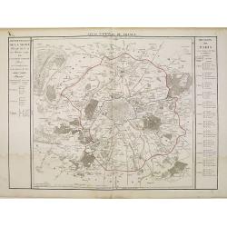
Departement de Paris en 12 Justices de Paix et 12 Maires.
Detailed map centered on Paris. Taken from "Atlas national de France", the first atlas with the departments of France published by Pierre Grégoire Chanlaire.
Date: Paris, P.G. Chanlaire, 1818
Selling price: ????
Please login to see price!
Sold
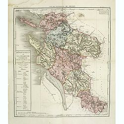
Département de la Charente inférieure decreté le 6 février 1790. . .
Map of region of west of France. Region of Charente inférieure divided into 7 districts. explicative text with the division of the districts and cantons.Sheet No. 38 fro...
Date: Paris, 1790-1818
Selling price: ????
Please login to see price!
Sold
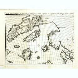
Carta da navegar de Nicolo et Antonio Zeni Furono in Tramontana Lano MCCCLXXX.
An early 19th-century example of Nicolo Zeno's map of the North Atlantic, based upon the legend of a 14th Century Venetian Zeno family and their reported travels to the N...
Date: Venice, 1818
Selling price: ????
Please login to see price!
Sold in 2016
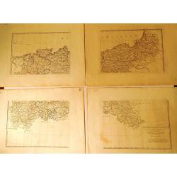
La Bassa Germania (4 Maps)
Four rare maps from "Atlante Geografico" by the priest Bartolomeo Borghi. This was considered as the most important Florentine atlas. The four maps are hand mar...
Date: Florence, 1818
Selling price: ????
Please login to see price!
Sold in 2015
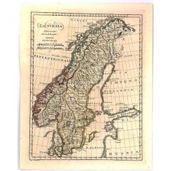
La Svezia Norissima.
A fine detailed map of Sweden
Date: Florence, 1818
Selling price: ????
Please login to see price!
Sold in 2016
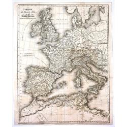
A Map of the Western Part of the Roman Empire.
Interesting map of the western Roman Empire in Europe with both the current names and ancient names. By Sidney Hall and published by Longman, Hurst et al. in London in 18...
Date: London, 1818
Selling price: ????
Please login to see price!
Sold in 2017
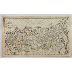
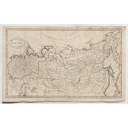
Russian Empire from the Best Authorities.
A fine copper engraved map of the Russian Empire, published in “An Atlas to Guthrie's Geographical Grammar” published in London in 1818.
Date: London, 1818
Selling price: ????
Please login to see price!
Sold in 2018
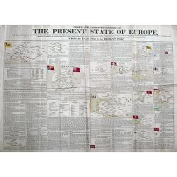
Third and Improved Edition of The Present State of Europe, With Maps of the Territories, as Settled by the Congress of Vienna.
A rare broadside printed on two sheets, showing the political changes of Europe between 1783 and 1818. With 14 inset maps, some with their flags. Extensive text about eac...
Date: Derby, ca 1818
Selling price: ????
Please login to see price!
Sold in 2018
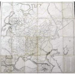
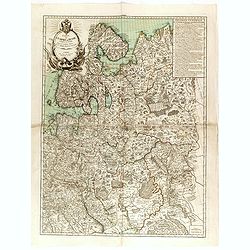
Carte de la Partie Européenne de l'Empire de Russie...
Uncommon and impressive large map of European Russia. Extends from the White Sea until the Black Sea in the South, and the Baltic Sea in the west to the Caspian Sea in th...
Date: St. Petersburg, 1818
Selling price: ????
Please login to see price!
Sold in 2019
Russian Empire from the Best Authorities.
A detailed map of Russia by Guthrie from “Guthrie’s Geography” published in London in 1818.William Guthrie (1708-1770) Guthrie was born in Brechin in Scotland. He w...
Date: London, 1818
Selling price: ????
Please login to see price!
Sold in 2020
Nuova Pianta Iconografía dell' Inclita Città di Venezia.
A magnificient and decorative copper engraved city map of Venice, engraved and published by Teodoro Viero (1740-1819) in 1818. Based on the plan by Ludovico Ughi plan pub...
Date: Venice, 1818
Selling price: ????
Please login to see price!
Sold in 2021
![Untitled. [Villefranche-sur-Mer]](/uploads/cache/90633-250x250.jpg)
Untitled. [Villefranche-sur-Mer]
Rare manuscript map of Villefranche-sur-Mer near Nice in southern France. Includes Mont Boron (here called Monboroni) and the peninsula of Saint-Jean-Cap-Ferrat. Finely e...
Date: France, 1819
Selling price: ????
Please login to see price!
Sold in 2008
Carte d'Allemagne dressée sur les observations Astronomiques et Géographiques. . .
Uncommon map published by Dezauche after G. de l'Isle however updated according to the Treaty of Paris of 1815, which was signed on 20 November 1815 following the defeat ...
Date: Paris, 1819
Selling price: ????
Please login to see price!
Sold in 2019

Set of 8 views from 'Source of the Thames'
Lovely set of seven highly attractive engraved views and the titlepage, by Cooke from his "Source of the Thames". The very decorative views, include much detail...
Date: London, 1819
Selling price: ????
Please login to see price!
Sold in 2011
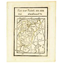
Kort over Rusland 1819 S.E.H.
Rare wood block printed map of European part of Russia, including Finland.
Date: Denmark, 1819
Selling price: ????
Please login to see price!
Sold in 2013
Mappa Dioecensis Alba-Regalensis . . .
Rare two sheet map of Albensis in Hungary, pre pared by Janor Pongratz, who was an Hungarian engraver and military cartographer and served as a lieutenant in the second R...
Date: Budapest, ca. 1819
Selling price: ????
Please login to see price!
Sold in 2018
La Svezia Norissima.
A detailed map of Sweden and Norway from the rare "Geographic Atlas" by Borghi. Abbot Bartolomeo Borghi (1750-1821), was a cartographer, engraver and publisher....
Date: Florence, 1819
Selling price: ????
Please login to see price!
Sold in 2018
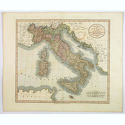
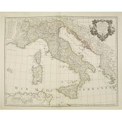
A New Map of Italy. . .
An attractive and beautifully engraved map of Italy by English cartographer John Cary, published in London in 1819. The map shows the country divided into its many duchie...
Date: London, 1819
Selling price: ????
Please login to see price!
Sold in 2020
A Map of the Present Seat of War in the North of Europe.
A striking, detailed, uncommon and large, 1819 Laurie & Whittle's copperplate map of European Russia, at the time of the French Invasion of Russia. It extends to cove...
Date: London, 1819
Selling price: ????
Please login to see price!
Sold in 2021
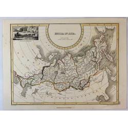
Russia in Asia.
An interesting map Russian Asia, mainly that of Siberia. It extends from Europe to the NW coast of America. Features a decorative vignette of a winter scene with sled and...
Date: Edinburgh, 1819
Selling price: ????
Please login to see price!
Sold in 2019
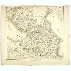
Carte générale du pays entre les mers Noire et Caspienne, avec la désignation des nouvelles frontières de la Russie et de la Perse. . .
A stunning map of Georgia, Armenia, and Azerbaijan. Area of coverage extends from the Black Sea to the Caspian Sea. This beautifully rendered map is truly a masterpiece o...
Date: Paris, 1819
Selling price: ????
Please login to see price!
Sold in 2020
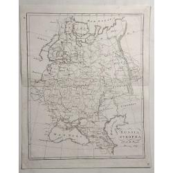
Russia Europea.
Detailed example of Bartolomeo Borghi’s 1819 engraved map of the Russian Empire in Europe. Includes Russia, Ukraine, Crimean Peninsula, Finland, Poland, Lithuania, Lat...
Date: Florence, 1819
Selling price: ????
Please login to see price!
Sold in 2023
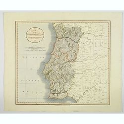
A New Map of the Kingdom of Portugal.
A fine and detailed map of Portugal by John Cary, with the various provinces in pale wash color. Showing mountains, roads, rivers and numerous village and towns. Interest...
Date: London, 1819
Selling price: ????
Please login to see price!
Sold in 2020
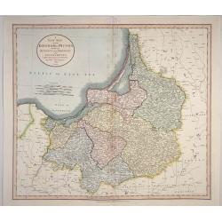
A New map of the Kingdom of Prussia. . .
A New map of the Kingdom of Prussia with its Divisions into Provinces and Governments. Accurate map of Prussia which is now northern Poland and Lithuania. With title at t...
Date: London, 1819
Selling price: ????
Please login to see price!
Sold in 2023
A New map of the Kingdom of Denmark, Comprehending North and South Jutland, Zeeland, Fyen, Laaland, and Part of Holstein.
An accurate map of Denmark by John Cary who was considered 'the most representative, able and prolific of English cartographers'. Tooley says, 'As an engraver he was eleg...
Date: London, 1819
Selling price: ????
Please login to see price!
Sold in 2020
A New Map of Sweden, Denmark and Norway from the Latest Authorities.
An accurate map of Scandinavia by John Cary who was considered 'the most representative, able and prolific of English cartographers'. Tooley says, 'As an engraver he was ...
Date: London, 1819
Selling price: ????
Please login to see price!
Sold in 2020
Carte de la Guienne, de la Navarre et du Bérn.
A detailed map of Guienne and Gascoigne. Engraved by Vallet.
Date: Paris, 1820
Selling price: ????
Please login to see price!
Sold
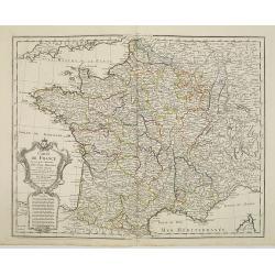
Carte de France.
Detailed map of France, with an updated date of "An 9" 1820 in the large allegoric title cartouche with a detailed title and dedication to the famous French car...
Date: Paris, 1820
Selling price: ????
Please login to see price!
Sold

Place de la Foire à Venise.
Basset was a well-known publisher of optical prints, established in rue St Jacques in Paris. In the 18th century the optical print or vue d'optique came into existence, w...
Date: Paris, c.1820
Selling price: ????
Please login to see price!
Sold in 2010

Vue de la Cathédrale de Milan
Basset was a well-known publisher of optical prints, established in rue St Jacques in Paris. In the 18th century the optical print or vue d'optique came into existence, w...
Date: Paris, c.1820
Selling price: ????
Please login to see price!
Sold in 2011

Vue du pont de Rïalto à Venise.
Basset was a well-known publisher of optical prints, established in rue St Jacques in Paris. In the 18th century the optical print or vue d'optique came into existence, w...
Date: Paris, c.1820
Selling price: ????
Please login to see price!
Sold in 2010

Vue de la grande rue et du château à Edimbourg
Optical print of the Caste of Edinburgh. Basset was a well-known publisher of optical prints, established in rue St Jacques in Paris. In the 18th century the optical prin...
Date: Paris, c.1820
Selling price: ????
Please login to see price!
Sold in 2008
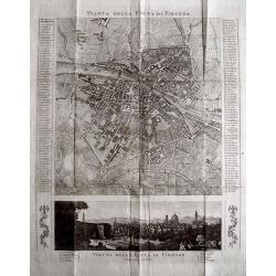
PIANTA DELLA CITTÀ DI FIRENZE.
Rare copper engraved city map of Florence. Extremely detailed plan showing buildings, piazzas, and naming 186 streets in side panels! Below with a view of the city taken ...
Date: c1820
Selling price: ????
Please login to see price!
Sold in 2013
Panorama London.
A separately published key sheet for Robert and Henry Aston Barker’s ‘Panorama of London painted as if viewed from the roof of Albion Mills on the South Bank,’ and ...
Date: London ?, ca. 1820
Selling price: ????
Please login to see price!
Sold in 2017
Carte générale de l'Empire de Russie comprise en Europe, pour l'intelligence de la guerre présente entre l'Impératrice de toutes les Russies et le Turc. . .
Rare and detailed two-sheet map of European Russia, Finland, Lapland and Baltic States with an ornamental title cartouche in the upper left corner. Prepared by Maurille A...
Date: Paris, ca. 1820
Selling price: ????
Please login to see price!
Sold in 2014

Vue du Palais de la Bourse.
Optical view of the stock exchange in Paris. In the eighteenth and nineteenth centuries there were many popular specialty establishments in Paris, Augsburg and London, wh...
Date: Paris, ca. 1820
Selling price: ????
Please login to see price!
Sold in 2019
A Map of the Western Part of the Roman Empire
An interesting map of Europe and North Africa during the time it was ruled by the Roman Empire. The names are those as used during that time of occupation. Published by T...
Date: London, 1820
Selling price: ????
Please login to see price!
Sold in 2016
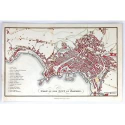
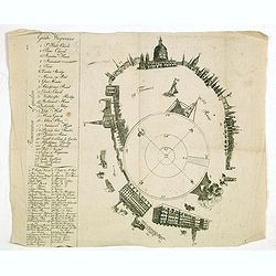
Plan of the City of Naples
A detailed plan of the city of Naples, Italy. The main attractions of Naples are listed in a table to the left. Published by Samuel Leigh in London, about 1820. Engraved ...
Date: London, ca.1820
Selling price: ????
Please login to see price!
Sold in 2016
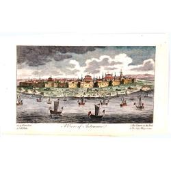
A View of Astracan.
A striking and highly detailed copper engraved panoramic view of Astrakhan,
Date: London, 1820
Selling price: ????
Please login to see price!
Sold in 2016

Bataille de la Moskowa, livrée le 7 septembre 1812.
Engraved plate of the battle of the Moskowa (or Borodino - 150 km from Moscow), on 7 September 1812. Napoleon is shown to the right, mounted on a white horse standing on ...
Date: Paris, ca.1820
Selling price: ????
Please login to see price!
Sold in 2017
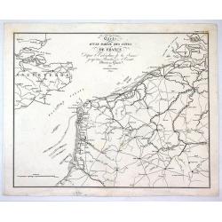
Carte D'Une Partie des Cotes de France.
Minimally detailed map of northern France and southeast Britain by Ambrose Tardieu from:"Precis des Evenements Militaires de plans et de Cartes". It shows Franc...
Date: Paris , 1820
Selling price: ????
Please login to see price!
Sold in 2017
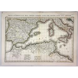
Parte Occidentale Dell Impero Romano Ossia del Mondo Noto Agli Antichi.
A fine map of the Mediterranean Sea with Spain, Italy, Sicily, Sardinia and Northern Africa as they were during the Roman Empire. By L. Rossi in Milan in 1820. Published ...
Date: Milan, 1820
Selling price: ????
Please login to see price!
Sold in 2018
General Charte von der Europaischem Türkey
Nice map of Greece, Albania, etc by Johannes Walch.Johann Walch (1757-1824) was cartographer and map publisher active in Augsburg, he was the son-in-law of Johann Martin ...
Date: Augsburg, 1820
Selling price: ????
Please login to see price!
Sold in 2019
Carte générale de L'Europe. . .
Map of Europe prepared by Felix Delamarche, after R.de Vaugondy. In the right hand a lengthy description of geographical details of the different European countries, moun...
Date: Paris, 1820
Selling price: ????
Please login to see price!
Sold in 2020
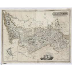
Stirlingshire.
A fine map of Stirlingshire, Scotland by Thomson in 1820. From his Atlas of Scotland published in Edinburgh. It features an inset of the town of Stirling and an engravin...
Date: Edinburgh, 1820
Selling price: ????
Please login to see price!
Sold in 2023
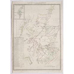
Index Map to the Atlas of Scotland.
An informative index for Thomson’s “Atlas of Scotland”. Published in 1820 in Edinburgh. It outlines all of the shires in Scotland and states the square miles. It f...
Date: Edinburgh, 1820
Selling price: ????
Please login to see price!
Sold in 2020
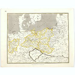
Prussia.
An early nineteenth century map of Prussia, published in Edinburgh. It also shows the southern tip of Sweden, Denmark, and extends as far south as the Carpathian Mountain...
Date: Edinburgh, 1820
Selling price: ????
Please login to see price!
Sold in 2021
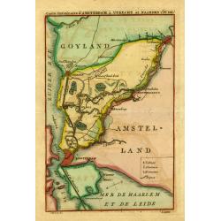
" Carte.. Amsterdam, á Utrecht et Naarden."
Uncommon map showing the road and river Vecht from Amsterdam to Utrecht. Including Naarden, Muiden, Weesp, Loenen, Maarsen, etc.
Date: Amsterdam 1821
Selling price: ????
Please login to see price!
Sold