Browse Listings in Europe
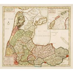
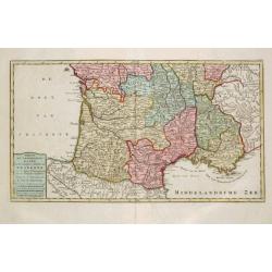
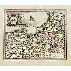
NoordHollands..WestFriesland..Dregterland..Koggen enz.
A very detailed map of North Holland also showing the famous cities Enkhuizen, Hoorn and Alkmaar. With an inset of the islands Texel, Vlieland and Terschelling.
Date: Amsterdam 1769
Selling price: ????
Please login to see price!
Sold
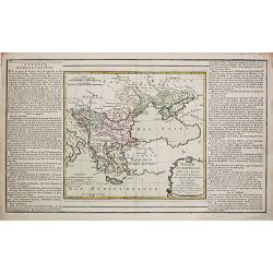
Turquie Européenne avec les états qui en sont tributaires.
Louis Brion de la Tour (1756-1823), ' Atlas Géneral, Civil et Ecclésiastique', 1766, ' Atlas Général', 1790-98. Louis Charles Desnos (fl.1750-70), Le Rouge's 'Atlas N...
Date: Paris, 1769
Selling price: ????
Please login to see price!
Sold
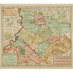
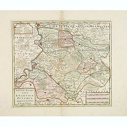
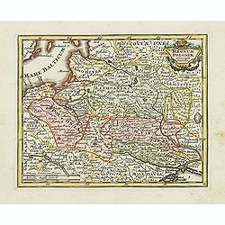
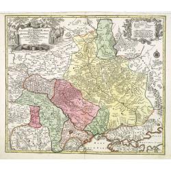
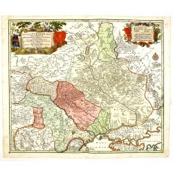
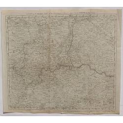
Nieuwe kaart van 't Kwartier Zutphen..
Map of the northern part of The Duchy Gelre, with Zutphen and Deventer.
Date: Amsterdam 1769
Selling price: ????
Please login to see price!
Sold
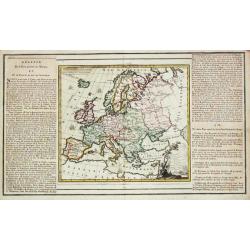
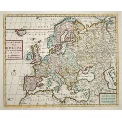
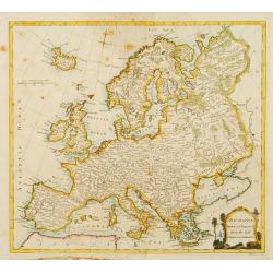
l' Europe.
Louis Brion de la Tour (1756-1823), ' Atlas Géneral, Civil et Ecclésiastique', 1766, ' Atlas Général', 1790-98. Louis Charles Desnos (fl.1750-70), Le Rouge's 'Atlas N...
Date: Paris, 1769
Selling price: ????
Please login to see price!
Sold
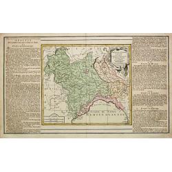
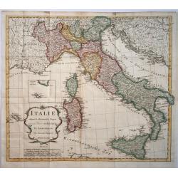
Partie de l' Italy Comprenant les etats du Roy de Sardaigne, de Milan, Parme et Génes.
Louis Brion de la Tour (1756-1823), ' Atlas Géneral, Civil et Ecclésiastique', 1766, ' Atlas Général', 1790-98. Louis Charles Desnos (fl.1750-70), Le Rouge's 'Atlas N...
Date: Paris, 1769
Selling price: ????
Please login to see price!
Sold
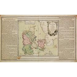
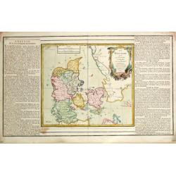
Le Danemark
Louis Brion de la Tour (1756-1823), ' Atlas Géneral, Civil et Ecclésiastique', 1766, ' Atlas Général', 1790-98. Louis Charles Desnos (fl.1750-70), Le Rouge's 'Atlas N...
Date: Paris, 1769
Selling price: ????
Please login to see price!
Sold
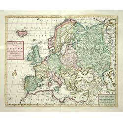
Nieuwe Kaart van Europa
Nice map of Europe extending to include Iceland. Political divisions are delineated in original color and major cities are located.
Date: Amsterdam 1769
Selling price: ????
Please login to see price!
Sold
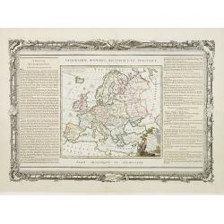
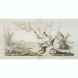
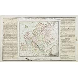
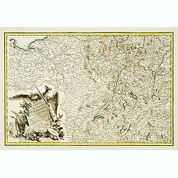
L'Europe Dressée..
Map of Europe, with an explanatory text on left/right sides. The map and the text are surrounded by a decorative frame, wrapped in garlands, on which stand out the instru...
Date: Paris, 1768-1769
Selling price: ????
Please login to see price!
Sold
Le Danemark
Louis Brion de la Tour (1756-1823), ' Atlas Géneral, Civil et Ecclésiastique', 1766, ' Atlas Général', 1790-98. Louis Charles Desnos (fl.1750-70), Le Rouge's 'Atlas N...
Date: Paris, 1769
Selling price: ????
Please login to see price!
Sold
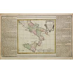
Etats des deux Siciles.
Louis Brion de la Tour (1756-1823), ' Atlas Géneral, Civil et Ecclésiastique', 1766, ' Atlas Général', 1790-98. Louis Charles Desnos (fl.1750-70), Le Rouge's 'Atlas N...
Date: Paris, 1769
Selling price: ????
Please login to see price!
Sold
Nieuwe Kaart van Europa
Nice map of Europe extending to include Iceland. Political divisions are delineated in original color and major cities are located.
Date: Amsterdam, 1769
Selling price: ????
Please login to see price!
Sold
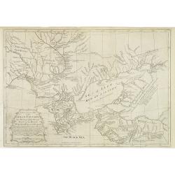
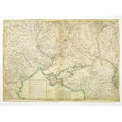
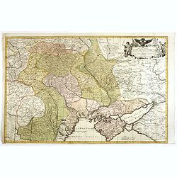
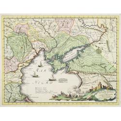
A New & Accurate Map of the Krim Tartary, the Sea of Azof, and Parts of the Rivers Dneper, Bog and Kuban.
Interesting, engraved map of the northern Black Sea and southern Ukraine regions, during the period of hostilities between the Turks and Russians, 1768-74. Published in t...
Date: London, 1769
Selling price: ????
Please login to see price!
Sold in 2013
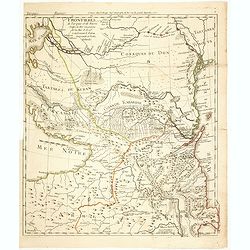
Nouveau théâtre de la guerre entre les Russes les turcs et les polonois confédérés.
Very rare separately published map of Crime region. With a large title cartouche lower left "Nouveau theâtre de la guerre entre les russes, les turcs et les polonoi...
Date: Paris, 1769
Selling price: ????
Please login to see price!
Sold in 2010
![[SET OF 5 MAPS OF THE CASPIAN SEA, RUSSIA, ca. 1769]](/uploads/cache/91829-250x250.jpg)
[SET OF 5 MAPS OF THE CASPIAN SEA, RUSSIA, ca. 1769]
Interesting set of five copper-engraved maps of the Caspian Sea by or after D'Anville, dating to around 1769. List of the maps: 1: Premiere Révolution de la mer Caspie...
Date: Paris, c1769
Selling price: ????
Please login to see price!
Sold in 2011
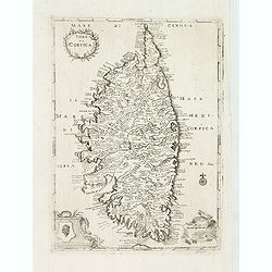
Isola di Corsica.
A very rare map of Corsica, published in " Relazione della Corsica, "which was an Italian translation of the work by Boswell " An Account of Corsica,"...
Date: London, 1769
Selling price: ????
Please login to see price!
Sold
(Dalmatien). Lower left sheet from the famous wall map 'Mappa Geographica novissima Regni Hungariae divisi in suos Comitatus'.
Lower left sheet from the famous wall map "Mappa Geographica novissima Regni Hungariae divisi in suos Comitatus" of Hungary. This part depicting part of Dalmati...
Date: Vienna, 1769
Selling price: ????
Please login to see price!
Sold
Nieuwe kaart van 't Kwartier Zutphen. . .
Map of the northern part of The Duchy Gelre, with Zutphen and Deventer.Isaac Tirion was born in Utrecht ca. 1705. He came to Amsterdam ca. 1725. Tirion published a number...
Date: Amsterdam, 1769
Selling price: ????
Please login to see price!
Sold in 2013
Nieuwe Kaart van Italie na de Nieuwste waarnemingen van de l'Isle en andere
Handsome and detailed map showing Italy as well as Corsica, Sardinia, Minorca, Croatia, Albania, Dalmatia, a bit of Provence, Malta and the northern coast of Africa. The ...
Date: Amsterdam 1769
Selling price: ????
Please login to see price!
Sold in 2014
L'Europe Dressée. . .
Map of Europe, with an explanatory text on left and right sides.
Date: Paris, 1768-1769
Selling price: ????
Please login to see price!
Sold in 2016
Carte exacte d'une Partie de L'Empire de Russie et de la Pologne meridionale renfermant l'Ukraine . . .
Rare map of Eastern Europe published by Facius Brothers, published in Bonn, including Poland, Lithuania, Russia and Ukraine. This is the first edition of the map, which w...
Date: Bonn, 1769
Selling price: ????
Please login to see price!
Sold in 2022
PLAN DE FLORENCE.
A superb and scarce map of Florence by Lalande, from from 'Voyage en Italie' by LALANDE, J. J. DE.., with a detailed legend.Joseph Jérôme Lefrançois de Lalande , 11 Ju...
Date: Paris, 1769
Selling price: ????
Please login to see price!
Sold in 2021
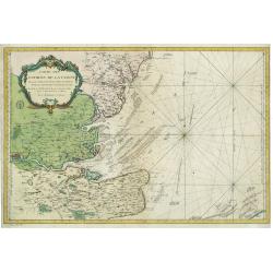
Carte Des Entrees De La Tamise
This is a beautiful antique nautical chart of the east coast of England, focusing on the counties of Suffolk Kent and Essex as well as the entrance to the Thames River. T...
Date: Paris, 1769
Selling price: ????
Please login to see price!
Sold in 2023
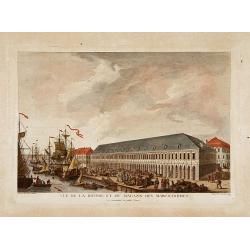
Vue de la bourse et du magazin des marchandises..
Fine view of the stock exchange and storehouses in St.Petersburg. Drawn and engraved under the direction of the imperial Academy of sciences and arts of Russia. After a d...
Date: Saint-Petersburg 1770
Selling price: ????
Please login to see price!
Sold
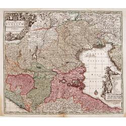
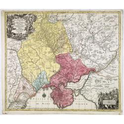
Dominium Venetum..
Seutter's well-engraved map has a large decorative cartouche. Detailed map centred on Venice.The map is in original wash color and has an uncolored cartouche.
Date: Nuremberg 1770
Selling price: ????
Please login to see price!
Sold
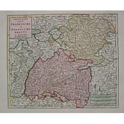
Nieuwe Kaart van de Frankische en Zwabische Kreits.
Izaac Tirion (d. 1769) Amsterdam publisher. His 'Nieuwe en beknopte handatlas' saw 6 editions between before 1740 and after 1784. Also 'Tegenwoordige staat van alle volke...
Date: Amsterdam, c. 1770
Selling price: ????
Please login to see price!
Sold
Carte de l'Empire d'Alemagne..
Detailed map depicting parts of France, Switzerland and Germany. Embellished with allegorical cartouche.
Date: Paris, 1770
Selling price: ????
Please login to see price!
Sold
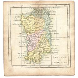
Royaume De Sardaigne
A map showing Sardinia from the uncommon miniature atlas Almanach Geographique ou Petit Atlas Elémentaire, published by Desnos in Paris ca. 1770. Acclaimed French map ...
Date: Paris ca. 1770
Selling price: ????
Please login to see price!
Sold
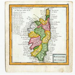
Royaume De Corse.
A map showing Corsica from the uncommon miniature atlas Almanach Geographique ou Petit Atlas Elémentaire, published by Desnos in Paris ca. 1770. Acclaimed French map pub...
Date: Paris ca. 1770
Selling price: ????
Please login to see price!
Sold
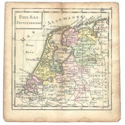
Pays Bas Septentrionalis
A map from the uncommon miniature atlas Almanach Geographique ou Petit Atlas Elémentaire, published by Desnos in Paris ca. 1770. Acclaimed French map publisher and globe...
Date: Paris ca. 1770
Selling price: ????
Please login to see price!
Sold
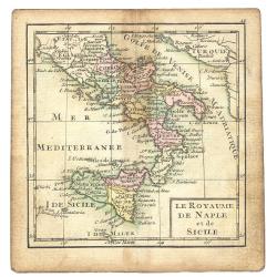
Le Royaume De Naple et de Sicile
A map from the uncommon miniature atlas Almanach Geographique ou Petit Atlas Elémentaire, published by Desnos in Paris ca. 1770. Acclaimed French map publisher and globe...
Date: Paris ca. 1770
Selling price: ????
Please login to see price!
Sold
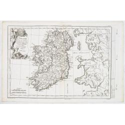
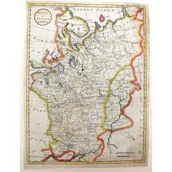
L'Irlande. . .
Fine detailed and uncommon map of Ireland. Prepared by Etienne André Philippe de Pretot (1708-1787) a royal censor and professor of history at the Royal Academy of Scien...
Date: Paris, 1770
Selling price: ????
Please login to see price!
Sold in 2013
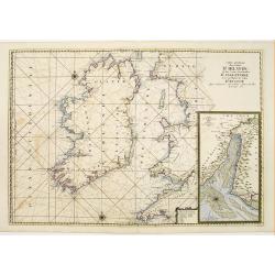
Carte Generale des Costes D'Irelande et des Costes..d'Angleterre avec une Partie de celles D'Ecosse..
Attractive chart. Whole of Ireland and England from Ayr to Plymouth. Large scale inset of the Dee estuary up to Chester in decorative frame. Latitude and longitude scales...
Date: Paris 1770
Selling price: ????
Please login to see price!
Sold
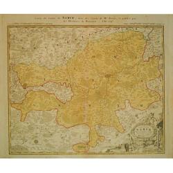
Carte de Namur.
Johann Baptist Homann (1663-1724). Outstanding German cartographer. Founder of the Homann publishing house. After the death of the son Johann Christoph, the firm continue...
Date: Nürnberg, c. 1770
Selling price: ????
Please login to see price!
Sold in 2013
Commitatus Hannoniae.
Johan Baptist Homann (1663-1724). Outstanding German cartographer. Founder of the Homann publishing house. After the death of the son Johann Christoph, the firm continued...
Date: Nürnberg, c. 1770
Selling price: ????
Please login to see price!
Sold in 2013
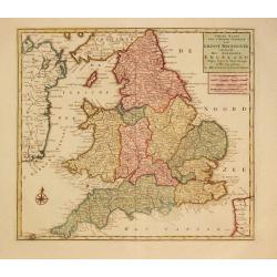
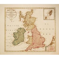
Nieuwe Kaaart van 't Zuider Gedeelte van Groot Britannie behelsende Het Koningryk Engeland.
Izaak Tirion (d. 1769) Amsterdam publisher. His ' Nieuwe en beknopte handatlas' saw 6 editions between before 1740 and after 1784. Also ' Tegenwoordige staat van alle vol...
Date: Amsterdam, c. 1770
Selling price: ????
Please login to see price!
Sold in 2020
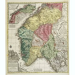
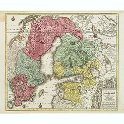
Regnum Norwegiae accurata et novissima delineatione?
Uncommon map of Norway. T.C. Lotter married M. Seutter's daughter in 1740 and succeeded him in 1756. Lotter used the copperplate of Seutter, he only changed the name.
Date: Augsbourg, 1770
Selling price: ????
Please login to see price!
Sold
L'Angleterre..
Fine detailed and uncommon map of England. Prepared by Etienne André Philippe de Pretot (1708-1787) a royal censor and professor of history at the Royal Academy of Scien...
Date: Paris, 1770
Selling price: ????
Please login to see price!
Sold in 2011
Magni Ducatus Finlandiae?
The map is based on the archetypal map of the Swede Anders Bure. T.C. Lotter married M. Seutter's daughter in 1740 and succeeded him in 1756. Lotter used the copperplate ...
Date: Augsbourg, 1770
Selling price: ????
Please login to see price!
Sold
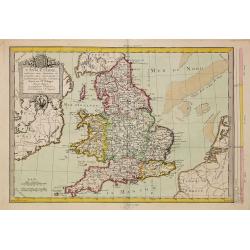
Nieuwe Kaart van de Eilanden van Groot Brittannien behelzende de Koningryken Engeland, Scotland en ierland.
Izaak Tirion (d. 1769) Amsterdam publisher. His ' Nieuwe en beknopte handatlas' saw 6 editions between before 1740 and after 1784. Also ' Tegenwoordige staat van alle vol...
Date: Amsterdam, c. 1770
Selling price: ????
Please login to see price!
Sold in 2010
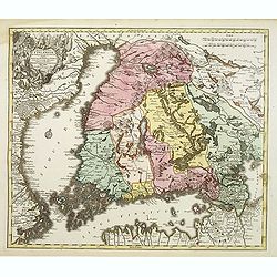
Nova mappa geographica Sueciae ac Gothiae regna ut et Finlandiae Ducatum ac Lapponiam?
Fine map including most of Sweden, Lapland and Finland.T.C. Lotter married M. Seutter's daughter in 1740 and succeeded him in 1756. Lotter used the copperplate of Seutter...
Date: Augsbourg, 1770
Selling price: ????
Please login to see price!
Sold in 2010
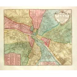
Nieuwe kaart der platte Grond van de Stad Parys en derzelve voorsteden
Izaak Tirion (d. 1769) Amsterdam publisher. His ' Nieuwe en beknopte handatlas' saw 6 editions between before 1740 and after 1784. Also ' Tegenwoordige staat van alle vol...
Date: Amsterdam, c. 1770
Selling price: ????
Please login to see price!
Sold
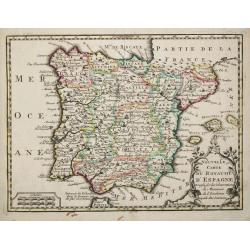
Nouvelle Carte du Royaume d' Espagne.
Attractive small map of the Iberian peninsula.
Date: Paris, c. 1770
Selling price: ????
Please login to see price!
Sold
Nieuwe kaart van het Zuidelykste Gedeelte van Frankryk.
Izaak Tirion (d. 1769) Amsterdam publisher. His ' Nieuwe en beknopte handatlas' saw 6 editions between before 1740 and after 1784. Also ' Tegenwoordige staat van alle vol...
Date: Amsterdam, c. 1770
Selling price: ????
Please login to see price!
Sold
Manuscript map Novara Piemonte.
Exceptional plan of Novara, dated 1770, link lower corner: 22 remarkable places noted. The author indicated (viator maior Aloysius Ruglerius). Scala di Bracia di Milano g...
Date: Italy, 1770
Selling price: ????
Please login to see price!
Sold in 2018
![[Untitled Russan provinces]](/uploads/cache/25959-250x250.jpg)
[Untitled Russan provinces]
Map of Russian provinces. Centered on Moscow. Engraved by Liebaux.
Date: Paris, ca 1770
Selling price: ????
Please login to see price!
Sold in 2010
Nuova Carta Geografica per servire alla storia della Guerra Presente tra la Russia, e la Porta Ottomana..
Decorative and rare map of the Black Sea Region and contiguous countries, centered on Crimea.With impressive title cartouche illustrating a siege of a stronghold. &cu...
Date: Venice, 1770
Selling price: ????
Please login to see price!
Sold in 2009
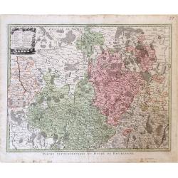
Partie Septentrionale du Duche de Bourgogne.
Map showing the Burgundy region of France. The cities of Auxonne and Dijon are shown in the lower right, Auxerre in the upper left and Chaumont in the upper right.
Date: Augsburg, 1770
Selling price: ????
Please login to see price!
Sold in 2010
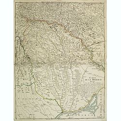
Carte de la Moldavie dressée sur celle du prince Cantimir. . .
Extremely rare map of the north of Moldavia and the regions today in Ukraine. In top the title Moldavie Septentrionale. Another map of the southern part exists to complem...
Date: Paris, 1770
Selling price: ????
Please login to see price!
Sold in 2011
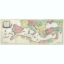
Carte Geographique representant la Mer Mediterranée ou la seconde Partie du Theatre de la Guerre entre les Russes et les Turcs C'est à dire les Roiaumes, les Etâts, les Provinces. . .
A beautiful map of the Mediterranean Sea. Embellished with three compass roses and sailing vessels, including a scene on a naval battle in the Atlantic off of Gibraltar.T...
Date: Augsbourg, 1770
Selling price: ????
Please login to see price!
Sold in 2014
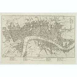
Accurater Plan der Stadt London nebst Westminster, Southwark und den neu angebauteten Haeusern vom Jahr 1767.
Uncommon plan of London with Hyde Park, Sadlers Wells, Mile End, Newington Butts. Underneath the plan a translation of English words used in the map into German below.Sig...
Date: Berlin, 1770
Selling price: ????
Please login to see price!
Sold in 2012
Regni Prussiae accurata delineatio.
Uncommon map of Prussia. The originally colored title cartouche is surrounded by mythological figures. From Atlas Portatif.
Date: Nuremberg, ca. 1770
Selling price: ????
Please login to see price!
Sold in 2012
Regnum Poloniae ejusque confinis.
Uncommon map of Poland. From Atlas Portatif.
Date: Nuremberg, ca. 1770
Selling price: ????
Please login to see price!
Sold in 2012
Russia in Europe by Thos. Bowen
Showing "Russia in Europe" by Thomas Bowen. It was engraved for and published by "Barlow's General History of Europe" in about 1770. The map covers th...
Date: London, c. 1770
Selling price: ????
Please login to see price!
Sold in 2015
Theatrum belli Russorum Victoriis illustratum sive Nova et accurata Turcicarum et Tartaricum. . .
This is the re-issue of Seutter's map with the Privilege in lower left part. Uncommon and decorative map of Ukraine, showing the theatre of the Russo-Turkish War in the U...
Date: Nuremberg, ca. 1770
Selling price: ????
Please login to see price!
Sold in 2016
Amplissima Ucraniae Regio, Palatinatus Kioviensem et Braclaviensem. . .
This is the re-issue of Seutter's map of Ukraine, with privilege underneath the title cartouche. With excellent detail of the topography, including rivers, hills, etc.Dec...
Date: Nuremberg, ca. 1770
Selling price: ????
Please login to see price!
Sold in 2013
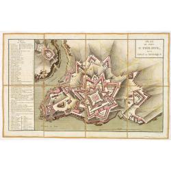
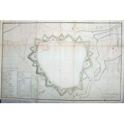
Plan du fort Saint-Philippe dans L'isle de Minorque.
A military plan of Fort St. Philip with a key to the left, with references to the fortifications de San Carlos (Q) et Malborough (R). In upper right corner "N°.3.&q...
Date: Paris, ca. 1770
Selling price: ????
Please login to see price!
Sold in 2013
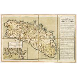
Carte Topographique et Militaire de L'Isle Minorque.
A fine map of Minorca with inset of the Bay of Mahon. With an extensive "Instruction" to the right "ette Carte levée et dessinée par des Officiers de l'A...
Date: Paris, ca. 1770
Selling price: ????
Please login to see price!
Sold in 2013
Amplissima Ucraniae Regio, Palatinatus Kioviensem et Braclaviensem. . .
Seutter's map of Ukraine, with privilege underneath the title cartouche. With excellent detail of the topography, including rivers, hills, etc.Decorated with two attracti...
Date: Nuremberg, ca. 1770
Selling price: ????
Please login to see price!
Sold in 2014
Frontieres de Turquie et de Russie Entre la Mer Caspienne et la Mer d'Asof renfermant le Kuban la Grande et Petitte Kabardie
Fine and rare map centered on present-day Georgia, Armenia and Azerbaijan. Depicting the progress of the Russo-Turkish war between 1768-1774. In bottom northern part of A...
Date: Paris, 1770
Selling price: ????
Please login to see price!
Sold in 2014
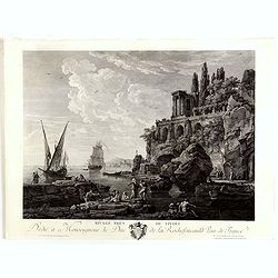
Ravage près de Tivoli.
Fine copper engraving after a design by Claude Joseph Vernet (1714 Avignon - 1789 Paris) and engraved by Jacques Aliamet. (1726 Abbeville-1788 Paris)
Date: Paris, Jean, ca.1770
Selling price: ????
Please login to see price!
Sold in 2014
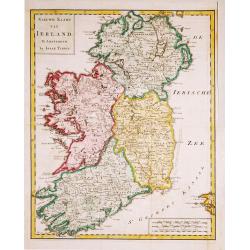
Nieuwe Kaart van Ierland.
28Izaak Tirion (d. 1769) Amsterdam publisher. His ' Nieuwe en beknopte handatlas' saw 6 editions between before 1740 and after 1784. Also ' Tegenwoordige staat van alle v...
Date: Amsterdam, c. 1770
Selling price: ????
Please login to see price!
Sold in 2015
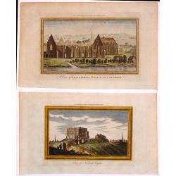
Two Hand-Colored Views of the Ruins of Ancient British Castles.
Two hand-colored views of English castles including: - "View of Norwich Castle" & - "A View of Lestwithiel Palace in Cornwall" These are copper ...
Date: London, 1770
Selling price: ????
Please login to see price!
Sold in 2018
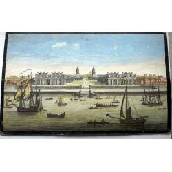
A View of the Royal Hospital at Greenwich.
An optical print of the Christopher Wren Old Royal Naval College from the Thames.
Date: London, circa 1770
Selling price: ????
Please login to see price!
Sold in 2022

Vue et Perspective de la Superbe Colomnade de Versailles.
Striking optical print featuring the columns and the gardens at Versailles, near Paris. France. In the eighteenth and nineteenth centuries many specialty establishments i...
Date: Paris, 1770
Selling price: ????
Please login to see price!
Sold in 2016
Neue Vorstellung von gantz Italien.
Unusual map of Italy during Roman times - from South Tyrol to Calabria, including a small part of Sicily. With numerous ancient place names. Published in "Neue Samml...
Date: Frankfurt, 1770
Selling price: ????
Please login to see price!
Sold in 2016

Vue de la Nouvelle Decoration de la Foire St. Germain.
A hand colored optical print published in Paris by Jacques Chereau in about 1770. During the 18th century there were several manufacturers of optical viewing devices and...
Date: Paris, ca. 1770
Selling price: ????
Please login to see price!
Sold in 2019
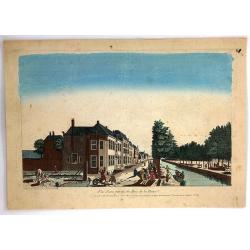
Vue d'Une Partie du Bois de la Haye.
A hand colored optical print published in Paris by Jacques Chereau in about 1770. During the 18th century there were several manufacturers of optical viewing devices and ...
Date: Paris, ca. 1770
Selling price: ????
Please login to see price!
Sold in 2019

Vue et Perspective d'Une Jardin du Roy d'Angleterre aux Environs de Londres.
A hand colored optical print of the King's garden in London, published in Paris by Basset in about 1770. During the 18th century there were several manufacturers of optic...
Date: Paris, ca. 1770
Selling price: ????
Please login to see price!
Sold in 2018
![Illumination en réjouissance du Mariage de Louis Auguste Dauphin de France avec l'Archiduchesse Marie Antoinette sœur de l'Empereur : [16 mai 1770].](/uploads/cache/37420-250x250.jpg)
Illumination en réjouissance du Mariage de Louis Auguste Dauphin de France avec l'Archiduchesse Marie Antoinette sœur de l'Empereur : [16 mai 1770].
J. Chereau was a publisher of optical print, established in Paris, rue St.Jacques. In the eighteenth and nineteenth centuries there were many popular speciality establish...
Date: Paris, ca. 1770
Selling price: ????
Please login to see price!
Sold in 2017
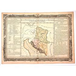
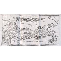
De la Pannonie, De la Liburnie, De la Dalmatie et de la Grece en General.
Fine map of what is now Croatia. By brion de la Tour and Charles Desnos in Paris in 1770. The map has much French text on either side and a very fancy border that was eng...
Date: Paris , 1770
Selling price: ????
Please login to see price!
Sold in 2017
![[Part of an Unknown Map.]](/uploads/cache/98331-250x250.jpg)
[Part of an Unknown Map.]
Upper left sheet of a large four sheet map. The most pronounced label on he map is "Comte de Virnenborg", Virneburg is a municipality in the district of Mayen-K...
Date: Paris, ca. 1770
Selling price: ????
Please login to see price!
Sold in 2017
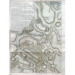
Feldschlacht bey Baschkiwizi in welcher Fürst Alexander Gallizin auf dem Marsche von Tschernowiz gegen Chozim von 70.000 Tartarn und Türken. . .
A very rare plan of the battle near Chotyn in the year 1769. The city was besieged by the Russian prince Alexander Galitzine. Khotyn is a city in Chernivtsi Oblast of wes...
Date: Vienna, ca 1770
Selling price: ????
Please login to see price!
Sold in 2019
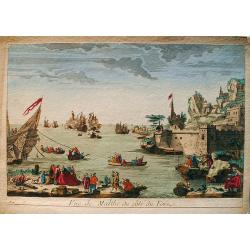
Vue de Malthe du côté du Fort.
An old colored optical view of Valetta, the capital of the Isle of Malta. On the right hand the fortresses. On the left is an on going sea battle. Made by an anonymous en...
Date: Unknown, ca 1770
Selling price: ????
Please login to see price!
Sold in 2019
![Plan of the Town of Chockzin [Khotyn] taken from the Turks by the Russians under Marshal Munich. [Khotin]](/uploads/cache/83608-250x250.jpg)
Plan of the Town of Chockzin [Khotyn] taken from the Turks by the Russians under Marshal Munich. [Khotin]
A rare, nicely colored map of the town of Chokzin or Choczim in the historical region of Moldavia, which spans today's Ukraine, Romania and Moldavia. Showing the district...
Date: London, 1770
Selling price: ????
Please login to see price!
Sold in 2020
A New and Correct Map of the Countries twenty Miles Round London.
A detailed map of the counties within 20 miles around London by Bowen in 1770. Thomas Bowen (1733-1790) was the son of Emanuel Bowen and became a map maker, engraver and ...
Date: London, 1770
Selling price: ????
Please login to see price!
Sold in 2020
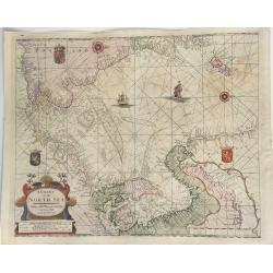
A Chart of the North Sea.
This extremely rare, large sea chart depicts the European North Sea. It is probably the last and possibly unrecorded state of the sea charts of the North Sea produced by ...
Date: London, ca 1770
Selling price: ????
Please login to see price!
Sold in 2023
Europa Drawn and Engraved from the best maps and charts.
Fine map of the continent of Europe.
Date: London 1771
Selling price: ????
Please login to see price!
Sold
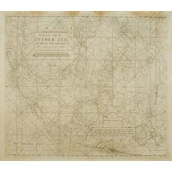
Paskaarte van de Zuyder zee met alle des Zelfs inkoomende Gaaten A° 1771.
Latitude scale, compass rose and system of rhumb lines, soundings, anchorage's, etc. A wealth of cities and information appear in the chart. This is an update of an older...
Date: Amsterdam 1753/1771
Selling price: ????
Please login to see price!
Sold
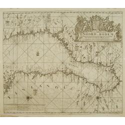
Nieuwe paskaart van de NOORD BODEM.
Latitude scale, compass rose and system of rhumb lines, soundings, anchorage's, etc. A wealth of cities and information appear in the chart. This is an update of an older...
Date: Amsterdam 1771
Selling price: ????
Please login to see price!
Sold
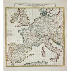
GERMANY, FRANCE ITALY, SPAIN, BRITISH ISLES, In an intermediate Century between Antient and Modern Geography.
Jean Baptist d' Après de Mannevilette (1707-1780), French hydrographer. His sea-atlas of the Asian waters, the ' Neptune Oriental 'was published in 1755.A map of western...
Date: London, R. Sayer and J. Bennett, 1771
Selling price: ????
Please login to see price!
Sold